Geochemical soil analysis and environmental reconstructions at the Neolithic and Chalcolithic settlement Kochegarovo-1 in the forest-steppe zone of Western Siberia

Author: Bikmulina L.R., Yakimov A.S., Bazhenov A.I., Mosin V.S.
Journal: Archaeology, Ethnology & Anthropology of Eurasia @journal-aeae-en
Section: Paleoenvironment, the stone age
Article in issue: 2 т.45, 2017.
Free access
Short address: https://sciup.org/145145310
IDR: 145145310 | DOI: 10.17746/1563-0110.2017.45.2.035-044
Text of the article Geochemical soil analysis and environmental reconstructions at the Neolithic and Chalcolithic settlement Kochegarovo-1 in the forest-steppe zone of Western Siberia
Pedogenesis plays an important part in the formation of landscapes, and affects the life-sustaining activities of people. In various historic periods, pedogenic processes proceeded differently, which was reflected in the formation of certain soil types. Study of soil formation features in time (correlation of pedogenic processes, their history, and distinct manifestation in profile) is one of the high-priority issues of modern paleogeographic science, in particular, paleopedology. Soil is a conservative element of landscape, which is capable of preserving for a long time information about ancient environmental conditions, in the form of properties and indicators in its profile. At the same time, there are soils that were eliminated from soil formation processes as a result of their overlap by natural or artificial fills. Along with other natural paleoarchives (spores and pollen of plants, phytoliths, paleontological materials), buried soils represent a valuable source of information about ancient environmental conditions, their variation, and their influence on ethnocultural processes. In this regard, study of soils under archaeological sites (cultural layers, burial mounds, fortified structures, transport systems) is of particular importance. Comprehensive studies of sites, started in the 1960s, have resulted in the creation of archaeological soil-science, a new area of interdisciplinary research (Demkin, 1997; Dergacheva, 1997). In the last decade, along with classical soil-archaeological studies, geochemical analysis of soils and cultural layers has been performed, which allows reconstruction of the subsistence activities of ancient populations. Noteworthy is the spatial heterogeneity of archaeological sites in terms of level of knowledge about their geochemical condition. The best-studied region is European Russia (Aleksandrovsky, Aleksandrovskaya, 2009; Bronnikova, Murashova, Yakushev, 2007; Golyeva, 2009; Demkin, 2000; Dolgikh, 2010; Druzhinina, 2012; Kalinin, Alekseev, 2008; Tatyanchenko, Alekseeva, Kalinin, 2013). Such studies in Western Siberia started a short time ago, and they have been sporadic so far (Valdayskikh, 2007; Safarova, Yakimov, 2012).
The purpose of our paper is to establish the regularities of chemical elements’ distribution in the soil-archaeological profile of a stratified site in the West Siberian forest-steppe; and to reconstruct the types of subsistence-activity of the ancient population, as well as the soil formation and sedimentation conditions (by the example of the Kochegarovo-1 settlement).
Area, objects, and methods of study
The territory under study is located in the southwestern part of the West Siberian depositional plain within the limits of the forest-steppe natural zone (Fig. 1). The regional climate is continental, and is characterized by an average yearly airtemperature of 1.1 °C and by an amount of precipitation of 360 mm (Kuznetsov, Egorov, 2001: 48).
Objects of the article were the cultural layers and natural soil horizons at the settlement of Kochegarovo-1, and of the modern soil in its vicinities. The archaeological site located on fluvial terrace I of the Miass River is at the boundary between the Mishkinsky and Yurgamyshsky districts of the Kurgan Region, 1 km west of the Kochegarovo village (55°36′N; 64°01′E) (Fig. 2).
About 2000 m2 of the settlement area, including eight Neolithic and Chalcolithic dwelling structures, have been studied by now. The archaeological collection consists of about 20 thousand stone and pottery items. The Neolithic complex is represented by semi-ovoid vessels with pointed bottoms, and straight or inwardly folded upper edges with bulges on the inner sides. Decoration is applied with incised, retreating-pricked, or stepping comb technique. The main ceramic assemblage stays within the Kozlov-Poludenka tradition. There are also Boborykino vessels: flat-bottomed, profiled, undecorated, or with incised or pricked decoration. The stone toolkit is represented mainly by a blade complex containing traditional tools, including retouched blades, angle burins, notched blades, and points. There are also single geometric microliths, end-scrapers on blades, endscrapers on flakes, and bifacially worked arrowheads. The Chalcolithic assemblage is characterized by comb, pit-comb, coarse-pricked pottery and a flake-and-blade stone toolkit, which is traditional for this region.
The soil-archaeological method (Demkin, 1997: 37) and X-ray fluorescence spectroscopy using a Spectroscan MAKC-GV spectrometer* served as the basic methods of study. Samples for analysis were taken using a continuous column on 3 cm intervals from the cultural layers and soils of settlement, and from the modern soil.
The age of the cultural layers has been determined by the method of radiocarbon dating, primarily from ceramic materials and coal (Vybornov, Mosin, Epimakhov, 2014; Mosin et al., 2014) (see Table )**. Pottery from the Neolithic assemblage (cultural layer 4) yielded twelve dates falling within the period of 5200–
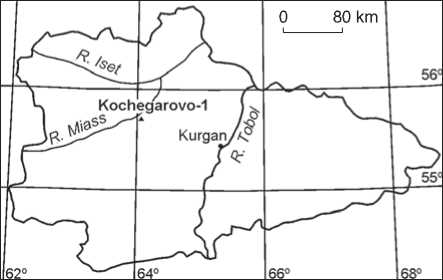
Fig. 1. Location of the Kochegarovo-1 settlement.
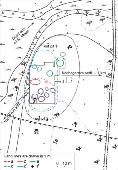
Fig. 2. Diagram of the Kochegarovo-1 settlement.
a – Neolithic settlement boundary; b – Chalcolithic settlement boundary; c – Neolithic dwelling depressions; d – Chalcolithic dwelling depressions; e – two mounds and an above-ground dwelling of the Bronze Age; f – zero reference point. S1 – soil-archaeological section; S2 – modern soil section.
3990 BC; Chalcolithic materials (cultural layer 2) gave four dates (three dates from pottery and one (SOAN-7067) from coal from the dwelling floor) within 4350– 3350 BC, which is in line with the general chronology of the Neolithic and Chalcolithic of the Urals.
Radiocarbon dates of materials from Kochegarovo-1 settlement
|
No. |
Code |
Date |
|
|
14С, BP |
Cal. (68.2 %), BC |
||
|
Neolithic complex |
|||
|
Kozlov tradition |
|||
|
1 |
Ki-16646 |
6050 ± 90 |
5200–4800 |
|
2 |
Ki-16856 |
5740 ± 90 |
4700–4490 |
|
3 |
SPb-1269 |
5952 ± 100 |
4964–4723 |
|
4 |
SPb-1272 |
6073 ± 100 |
5077–4843 |
|
5 |
SPb-1273 |
5817 ± 130 |
4806–4521 |
|
6 |
SPb-1274 |
5878 ± 120 |
4856–4591 |
|
Boborykino tradition |
|||
|
7 |
Ki-15542 |
5270 ± 80 |
4230–3990 |
|
8 |
Ki-16647 |
5920 ± 90 |
4940–4700 |
|
Poludenka Comb tradition |
|||
|
9 |
Ki-15543 |
5640 ± 90 |
4550–4350 |
|
10 |
Ki-15950 |
5950 ±90 |
4940–4710 |
|
11 |
Ki-16855 |
5630 ± 90 |
4550–4360 |
|
12 |
SPb-1271 |
5815 ± 150 |
4841–4494 |
|
Chalcolithic complex |
|||
|
13 |
Ki-15544 |
5220 ± 80 |
4230–3950 |
|
14 |
Ki-15962 |
5410 ± 90 |
4350–4070 |
|
15 |
Ki-16847 |
4660 ± 90 |
3630–3350 |
|
16 |
SOAN-7067 |
5170 ± 95 |
4230–3800 |
Morphology of soils and cultural layers
Soil-archaeological section. During the 2012 field season, a soil-archaeological section was established in a wall of a dwelling in the southwestern sector of the excavation area (Fig. 3). Its upper portion is represented by meadow-chernozem soil (Klassifikatsiya…, 1977: 98). The soddy horizon (Asod, 0–20 cm*) is a dark gray sandy clay of fine-crumb structure; friable, moistened; includes grass-roots and insect-holes; the lower boundary is uniform; the transition is noticeable in color. The humus horizon (A1, 20–41 cm) is a dark gray sandy clay of crumb structure; compacted, dry; includes grass-roots and
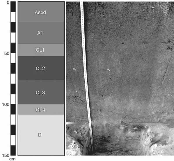
Fig. 3. Structure of soil-archaeological section of the Kochegarovo-1 settlement (see explanations in the text).
insect-holes; the lower boundary is uniform; the transition is noticeable in color and density. A series of cultural layers of various ages lies below. The first cultural layer (CL1, 41–52 cm) is a gray sandy clay of a fine-crumb structure, showing whitishness upon drying; packed, dry; includes grass roots and artifacts (remains of oven, slag); the lower boundary is uniform; the transition is noticeable in color and density; dated back to the Middle Ages. The second cultural layer (CL2, 52–76 cm) is a dark gray sandy clay of a fine-crumb structure, showing whitishness upon drying; very packed, dry; includes grass roots and artifacts (pottery); the lower boundary is uniform; the transition is noticeable in color; attributed to the Chalcolithic. The third cultural layer (CL3, 76–100 cm) is a gray sandy clay with light gray fragments, showing whitishness upon drying; a crumb structure; packed, dry; includes grass roots and burrowing animals’ holes; the lower boundary is uniform; the transition is noticeable in color; dated back to the transitional (from the Neolithic to the Chalcolithic) period. The fourth cultural layer (CL4, 100–110 cm) is a gray sandy clay with yellowish-brown fragments; a fine-crumb structure; friable, moistened; the lower boundary is uniform; the transition is clear in color; attributed to the Neolithic period. The underlying layer (D, 110–150 cm) is a yellow-brown coarse-grained alluvial sand; structureless, laminated, friable, moistened. The entire soil-archaeological profile is not reactive with 10 % hydrochloric acid (HCl).
Modern soil. The background section is located 25 m to the south of the archaeological site boundary (see Fig. 2). The modern soil belongs to the meadowchernozem type (Ibid.) and has the following structure (Fig. 4). The soddy horizon (Asod, 0–18 cm) is a dark gray sandy clay of fine-crumb structure; compacted, dry; includes abundant grass roots; the lower boundary is uniform; the transition is noticeable in color. The humus horizon (A1, 18–70 cm) is a dark gray sandy clay of crumb structure; packed, dry; contains grass roots, burrowing animals’ holes, coarse- and mediumgrained sand inclusions; the lower boundary is tongued; the transition is clear in color. The humic-illuvial horizon (AB, 70–97 cm) is a light sandy loam of light gray color with dark gray fragments; of blocky structure; packed, moistened; the lower boundary is undulating; the transition is noticeable in color. The illuvial horizon (B, 97–110 cm) is a light sandy loam of yellow-brown color with gray fragments; of blocky structure; compacted, moistened; the lower boundary is uniform; the transition is clear according to reaction with 10 % HCl. The parent rock material (Cca, 110– 135 cm) is a yellow-brown coarse-grained alluvial sand; structureless, compacted, moistened; includes carbonate neoformations in the form of white soft and farinaceous spots, grass roots; the lower boundary is uniform; the transition is clear according to extinction of reaction with 10 % HCl. The underlying layer (D, 135–150 cm)

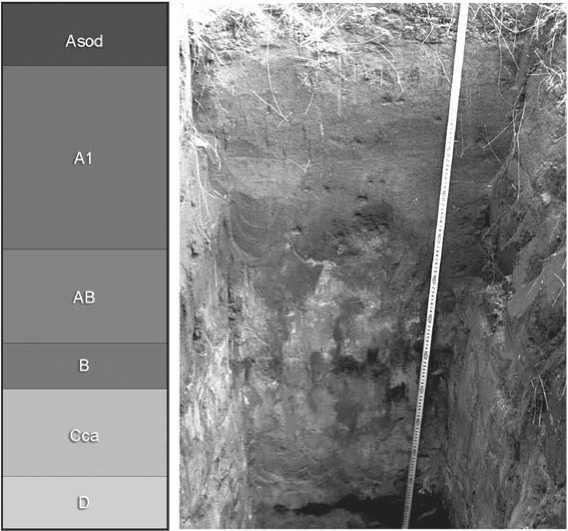
Fig. 4. Structure of modern soil (see explanations in the text).
is a yellow-brown coarse-grained alluvial sand; structureless, laminated, packed, moistened.
A comparative analysis of the morphological structure of soil-archaeological section and modern soil has revealed a number of common features and distinctions that stayed within the range of soil subtype. Soil profiles are characterized by a color-change from dark gray to yellow-brown from top downward, a light texture (sandy loam–light loam), inclusion of plant remains. The studied soils are underlain by sand alluvial deposits. At the same time, the modern soil is distinguished by the existence of reaction with 10 % HCl and by the presence of an independent horizon of carbonate accumulation (Cca) with carbonate neoformations. Besides, this soil is less structured, and its moisture content is recorded starting from a depth of 70 cm, while the moisture content in the soil-archaeological section can be observed starting from 100 cm.
Geochemical condition of soils and cultural layers
Distribution of elements throughout profiles. Data on distribution of 38 elements throughout the studied profiles have been obtained from the results of X-ray fluorescence spectroscopy. A comparative analysis of the phosphorus (P2O5), potassium (K2O), calcium (CaO), magnesium (MgO), manganese (MnO), and strontium
(Sr) content in the studied soils and cultural layers has been conducted. These elements are capable of forming stable accumulation zones, i.e. possess a low mobility. Besides, they are predominantly of biogenic origin, which allows them to be used as markers of human subsistence activities.
Phosphorus. This enters soils as animal-droppings, and also with plant remains (Velleste, 1952). Phosphorus is characterized by uniform distribution in the background profile, while its concentration does not exceed 0.2 % (Fig. 5). In the soil-archaeological section, the phosphorus content is 2–2.5 times higher in the cultural layers, where the maximum is recorded in CL3.
Potassium. Its content in the studied soils varies predominantly within 1 % (Fig. 5). The greatest value of approximately 2 % is recorded for the medium portion of the modern soil humus horizon. An insignificant increase in the potassium concentration is noted in the cultural layers.
Calcium. Its distribution in the studied sections is similar (Fig. 5). Notably, at the settlement, the calcium concentration is higher, and areas of its increased content coincide with the cultural layers. A sharp increase in concentration to 2–2.5 times recorded in the carbonated parent rock material of modern soil is related to natural factors.
Magnesium. The dynamics of its distribution are distinguished by a high frequency and amplitude, while the content varies within 1 % (Fig. 6). In general, the magnesium content in the soil-archaeological profile
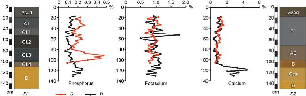
Fig. 5. Distribution of phosphorus, potassium, and calcium in the soil-archaeological (a) and background (b) profiles (S1 is the soil-archaeological section, S2 is the modern soil section).
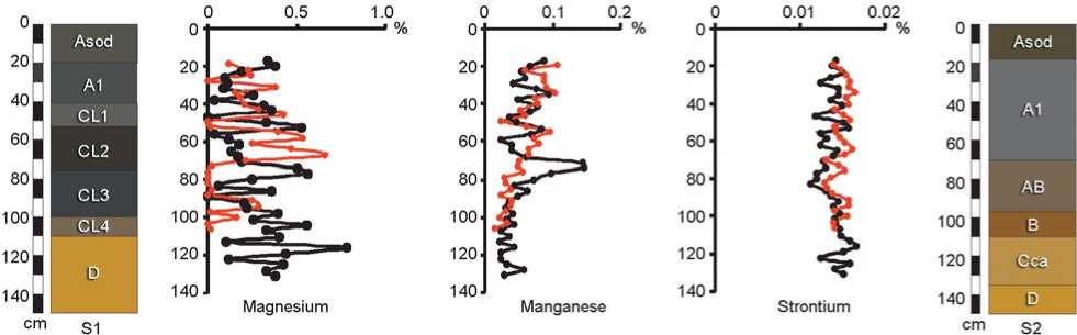
Fig. 6. Distribution of magnesium, manganese, and strontium in the soil-archaeological and background profiles. Legend same as on Fig. 5.
exceeds that in the background soil by 0.1–0.2 %, and the concentration zones are confined to the cultural layers. The greatest content of this element is recorded in the parent rock and makes up about 1 %.
Manganese. The tendency of its distribution in the studied profiles consists in a gradual decrease of its concentration with depth (Fig. 6). In general, the manganese content is somewhat higher at the settlement, and varies within 0.1 %. At the same time, its maximal amount is noted in the background soil humus horizon, where it does not exceed 0.2 %.
Strontium. The cultural layers of settlement tend to have an increased (to 1.5 times) concentration of strontium, as compared to that in the background soil, however, no more than 0.02 % (Fig. 6).
Thus, cultural layers represent the accumulation zones of the described elements, and are able to preserve them for a prolonged time and to maintain their distribution throughout the profile. The data on the structure of cultural layers, the content and the distribution of chemical elements therein are indicative of subsistence activities at the Kochegarovo-1 settlement, which continued throughout all occupation stages, but were most intense in the Chalcolithic.
Geochemical ratios and soil formation conditions. The methodological basis of geochemical ratios allows the reconstruction of soil formation and sedimentation conditions. Such research is novel for the forest-steppe zone of Western Siberia. There are 14 known geochemical ratios that are used in paleogeography (Kalinin, Alekseev, Savko, 2009: 7). Calculations for all indicators have demonstrated that six of them are most promising for paleoecological studies of the Kochegarovo-1 settlement and its vicinities.
CIA = [Al 2 O 3 /(Al 2 O 3 + CaO + Na 2 O + K 2 O)]×100. This indicator represents the relationship between primary and secondary minerals (Nesbitt, Young, 1982). In the soil-archaeological section, its dynamics are distinguished by small fluctuations within 65–75 %, and in all cultural layers an increase by 5–10 % as compared to other parts of profile is recorded (Fig. 7). In the modern soil, the CIA values are generally higher (75–80 %), however, there are zones (at a depth of 50–60 and 110–120 cm) with lower values (40–50 %).
Rb/Sr. This ratio demonstrates a varying resistance to weathering of micas and potassium feldspars (PFS) associated with rubidium, and carbonates associated with strontium (Gallet, Bor-ming, Masayuki, 1996). At the settlement, this indicator reduces from 0.7 to 0.2 c.u. with depth (Fig. 7). Also, its sharp decrease to 0.2 c.u. in CL1, and increase to 0.6 c.u. in the underlying CL2 is observed. In the background soil, the pattern of ratio distribution throughout the profile is uniform, but characterizes by greater changes of value (from 0.2 to 0.9 c.u.), and the maximal value is recorded at a depth of 70–80 cm.
Rb/Sr. This indicator characterizes hydrothermal conditions of sedimentation, in particular, the desalination process (Elizarova, 2006; Retallack, 2003). Barium is associated with PFS and is removed from soil weaker than strontium, which is associated with carbonates (Perelman, 1989: 59). The dynamics of the ratio distribution in the soil-archaeological section show high frequency and variations in the range of 1–3 c.u. (Fig. 7). Notably, increased values are observed in cultural layers 2–4 and, conversely, minimization is observed in CL3. The modern soil is characterized by a similar distribution of ratio throughout the profile, where the maximum is recorded at a depth of 50–60 cm, and the minimum is 10 cm lower.
MnO/Al2O3. This indicator gives an idea of the level of biological activity and productivity ( Vlag, Kruiver, Dekkers, 2004). At the settlement, this indicator gradually reduces with depth (Fig. 8). Its sharp decrease to the minimal value (less than 0.01 c.u.) is recorded in CL1. In other cultural layers, the ratio values are increased. Wide indicator fluctuations (from 0.01 to 0.04 c.u.) are noted in the modern soil profile, wherein the maximum is observed at a depth of 60–80 cm.
(CaO + MgO)/Al2O3. This ratio represents accumulation of soil calcite and dolomite (Retallack, 2003). The indicator gradually reduces down the soil-archaeological profile (Fig. 8). Its increase and decrease intervals are noted in CL2 and CL3, while a continuous decrease and a continuous increase are recorded in CL1 and CL4, respectively. The ratio value varies within the range of 0.2–0.4 c.u. A drastic change in its dynamics is observed outside of the settlement. The maximal value (1 c.u.) is recorded in the lower profile-part, and above the level of 100 cm, ratio values do not exceed 0.3 c.u.
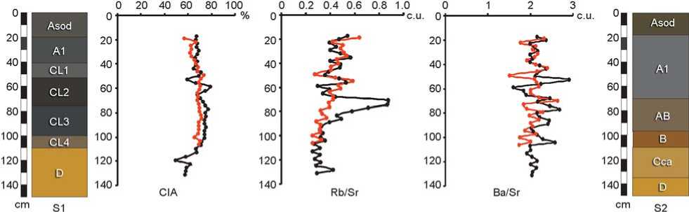
Fig. 7. Dynamics of the CIA, Rb/Sr, Ba/Sr geochemical ratios in the soil-archaeological and background profiles. Legend same as on Fig. 5.
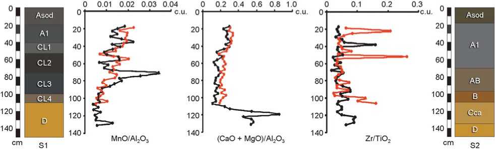
Fig. 8. Dynamics of the MnO/Al2O3, (CaO + MgO)/Al2O3, Zr/TiO2 geochemical ratios in the soil-archaeological and background profiles.
Legend same as on Fig. 5.
Zr/TiO2. It allows to evaluate the degree of material’s uniformity (Bushinsky, 1963; Schilman et al., 2001). At the settlement, this ratio is characterized by a drastic change in values from minimum (0.01 c.u.) to maximum (0.3 c.u.), wherein three peaks are recorded: in CL4, in the upper portion of CL2, and in horizon A1 (Fig. 8). The modern soil is distinguished by a lower variability of this indicator, which does not exceed 0.2 c.u.
Distribution of geochemical ratios in the soil-archaeological section and a comparative analysis with their dynamics in the modern soil enabled a number of features to be established. Increased values of all indicators (especially in CL2) are observed in the Neolithic and Chalcolithic cultural layers. At the same time, in CL2 and CL3, zones of lower ratios are recorded, which may be related to intense subsistence activities of the population in these periods. Of special note is CL1, where low values of indicators are observed. This is probably due to a great human-induced transformation of the cultural layer’s material. The modern soil is characterized by high frequency and amplitude of variations in geochemical ratios, and often demonstrates the general trend of their distribution in the soil-archaeological profile.
Reconstruction of the habitat of ancient population
The area of study was first peopled by prehistoric humans at the turn of the Early Neolithic and the Late Neolithic, which coincided with a change in the hydrological situation. During this time, a partial drying of the territory took place, semi-hydromorphic environmental conditions became established, and soil formation processes started. In the Neolithic, the settlement was located on a cape of the Miass River, and probably had a seasonal character, as it was occasionally flooded. Analysis of the cultural layer attributed to this period allows the conclusion that the first people settled down on the river beach (all Early Neolithic artifacts were found in the underlying layer of an alluvial sand), on the bank of the ancient channel of the Miass River (the boundary of iron-rich hydrogenous sands is recorded 5 km away from the settlement, in a northwestern direction). After the territory had dried, the suffosion process showed itself in the formation of kettle depressions, which were used by the ancient population to build several dwellings (this is evidenced by subsidence of the underlying layer (archaeological native soil) with overlying horizons and cultural layers). Anthropogenic impact in the Neolithic was minor, since signs of ancient pedogenesis and sedimentation can be distinctly seen in the cultural layer.
In the Chalcolithic, the Miass River ultimately receded, and new areas of land adjacent to the Neolithic settlement’s boundaries dried out. The environmental conditions of that time were characterized by an increase in continentality. Semi-hydromorphic environmental conditions were preserved. The settlement area increased and reached its peak. The thickness of cultural layers and their anthropogenic transformation are indicative of prolonged and intense subsistence activities in this period. The size and density of Chalcolithic population were at their maximum for all the time of settlement occupation. It should be noted that at the turn of the Neolithic and the Chalcolithic, one prolonged interruption in the functioning of the settlement took place, which is evidenced by a drastic difference between contemporaneous cultural layers (CL2 and CL3). By the end of Chalcolithic, the environmental conditions typical of river terraces had been established, which was accompanied by formation of transitional soil types—in particular, meadow-chernozem ones.
The final stage of the settlement’s existence is dated back to the Middle Ages. At that time, its occupation was short-term. The cultural layer is severely transformed by the remains of oven and combustion products (slag, coal). After the ancient population had left the settlement, the modern soil formation process of meadow-chernozem type started, and the medieval cultural layer (CL1) took on the role of the parent rock material.
Conclusions
The conducted comprehensive geochemical study of the cultural layers of the Kochegarovo-1 stratified settlement and of modern soil in its vicinity has made it possible to reveal a number of regularities in the intraprofile distribution of elements and calculated geochemical ratios. In addition, paleoecological reconstruction of the subsistence activities and habitat of population in the Neolithic and the Chalcolithic has been performed.
Six chemical elements (phosphorus, potassium, calcium, magnesium, manganese, and strontium) have been identified, which can serve as the markers for reconstruction of the subsistence activities of an ancient population. For the first time in this area, the geochemical ratios were used, allowing reconstruction of soil formation and sedimentation. It has been established that the most informative geochemical ratios are CIA, Rb/Sr, Ba/Sr, MnO/Al 2 O 3 , (CaO + MgO)/ Al2O3, and Zr/TiO2.
In the Early Neolithic period, after the Miass River channel had migrated, new areas of land were exposed, and semi-hydromorphic environmental conditions became established. In one of the dried areas, the Kochegarovo-1 settlement emerged, which was located on the river’s bank, in the immediate vicinity of the river, and was probably seasonal. According to the results of geochemical studies and archaeological materials, it has been established that the Neolithic population subsisted mainly by hunting, fishing, and gathering.
Anthropogenic impact was low, as evidenced by the structure of the cultural layer and its chemical composition. At the turn of the Neolithic and the Chalcolithic, at least one prolonged interruption took place in the functioning of the settlement.
In the Chalcolithic, owing to the further recession of the Miass River, the territory adjacent to the settlement dried. The environment remained semi-hydromorphic; however, by the end of the period, it changed to conditions typical of river terraces. The second stage of functioning of the settlement pertains to this period. It was inhabited during the longest season of the year, or throughout the year. The main subsistence activities of the population remained hunting and fishing, as evidenced by the recovered bones of such animals as bear, horse, elk, red deer, roe deer, badger, marten, and otter*, as well as by fish bones found on the floor of a Chalcolithic half-dugout dwelling. In addition, this is evidenced by analysis of the distribution of biogenic chemical elements in the soil-archaeological profile. Anthropogenic impact on the cultural layers was at its maximum in this period, as the layers are severely transformed, and their material is reworked.
The concluding stage of the settlement’s functioning is attributed to the Middle Ages. It is characterized by short duration and severe transformation of the cultural layer.
It should be specially noted that the studied objects were distinguished by a light texture. They show high responsiveness to varying environmental and anthropogenic conditions, and also poor preservation of materials. Nevertheless, the distribution and content of chemical elements, as well as the geochemical ratios in the cultural layers of various ages, have demonstrated the high potential of this method for paleoecological reconstructions at archaeological sites of the forest-steppe zone of Western Siberia.
