Geological and Geographical Expedition of A.A. Keyserling and P.I. Krusenstern to the European North-East of Russia

Author: Astakhova I.S., Zhdanova L.R.
Journal: Arctic and North @arctic-and-north
Section: Reviews and reports
Article in issue: 54, 2024.
Free access
The paper provides information about the expedition to the European North of Russia in 1843. The expedition travelled about 8000 miles (about 8427 km). The main route was connected with the waterway along the rivers Vychegda, Pechora, Izhma and their tributaries. Hiking routes were connected with the description of the Ural Mountains sites (Bolvano—Iz, Skala). On reindeer sledges, the expedition reached the coast of the Barents Sea and carried out geological and geographical work in the Timan tundra. The work was supervised by a paleontologist, corresponding member of the St. Petersburg Academy of Sciences, Count A.A. Keyserling. The scientist described and paleontologically characterized the rocks of the Lower Silurian, Devonian, Permian, Jurassic and Lower Cretaceous age. As a result of the expedition, the main minerals (coal, gypsum, oil, domanic, copper ore, salt, grindstone) were studied. The significant geological and geographical result was the discovery of the Timan Ridge and its mapping. P.I. Krusenstern conducted topographic surveys, astronomical and geographical observations. He compiled a geographical map on a scale of 1:3000000 with a rectangular geographic grid and detailed drawing of rivers, lakes and settlements. The published works of the scientists are kept in the funds of the A. A. Chernov Geological Museum, Institute of Geology.
History, expedition, Keyserling, Krusenstern, Timan, Pechora Krai
Short address: https://sciup.org/148329516
IDR: 148329516 | UDC: [55:913.1](092)(470.1)(045) | DOI: 10.37482/issn2221-2698.2024.54.206
Text of the scientific article Geological and Geographical Expedition of A.A. Keyserling and P.I. Krusenstern to the European North-East of Russia
DOI:
The year 2023 marks the 180th anniversary of the first geological and geographical work in the European North-East of Russia. In 1843, expeditionary research was carried out under the leadership of the famous naturalist, paleontologist, traveler, corresponding member of the St. Petersburg Academy of Sciences, Count A.A. Keyserling. The results obtained during the expedition played a major role in the study and development of the vast territory. In honor of these events, a memorial plaque was installed on the wall of one of the buildings in Syktyvkar (Fig. 1).
∗ © Astakhova I.S., Zhdanova L.R., 2024
This work is licensed under a CC BY-SA License
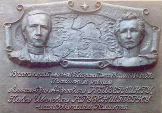
Fig. 1. Memorial plaque to A.A. Keyserling and P.I. Krusenstern in Syktyvkar.
The historical and archival collection of the A.A. Chernov Geological Museum (Syktyvkar) contains the works by A.A. Keyserling and P.I. Krusenstern, published in 1846, and the work of R. Murchison, E. Verneuil and A.A. Keyserling “Geological description of European Russia and the Ural Ridge” with a collection of geological maps, outcrops and sections, compiled by A.A. Keyser-ling [1], [2]. These materials were brought to the museum thanks to academician N.P. Yushkin, who preserved a part of the old collection of the library of the Russian Mineralogical Society in St. Petersburg and transported it to the Institute of Geology of the Komi Science Center (Fig. 2).
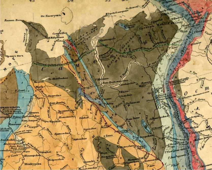
Fig. 2. Fragment of the geological map to the work of R. Murchison, E. Verneuil and A.A. Keyserling “Geological description of European Russia and the Ural Ridge”, 1849 [3].
Preconditions for the expedition in the Pechora Krai
At the beginning of the 19th century, the European North-East of Russia was socioeconomically part of the Vologda and Arkhangelsk provinces. During this period, generalized works on the economic and geographical description of the territories were published. In 1813, the work of K.S. Molchanov appeared, which mentioned copper ores on the Tsilma River and oil on the Ukhta River. A map of the Arkhangelsk province was provided, on which the main rivers are shown: Pechora, Tsilma, Usa, Izhma with the names of their tributaries [4].
In 1834, the book of the Vologda governor N.P. Brusilov “The experience of describing the Vologda province” was published, which is, in fact, a geographical description of the whole province, including Ust-Sysolskiy uyezd, which characterized the natural and human resources of the province. In fact, this was one of the first regional works [5]. It provides statistical data, describes the Seregovskiy salt plant and ironworks along the Sysola River. It mentions limestone mining near the mouth of the Vym River and in Ibskaya, Vizingskaya, Uzhginskaya volosts. The grinding stones of the Brusyanaya and Tochilnaya mountains on the Pechora River are described.
Difficult accessibility and climatic conditions hindered the development and scientific study of the region. Questions about communication routes across the Pechora River to the Urals and Siberia have been raised more than once. In 1785, a project was drawn up for the North-Ekaterininskiy Canal between the rivers North Kelma (a tributary of the Vychegda River) and Dzyuridzem, which flows into the Kama River. Construction of the canal continued until 1822.
In 1806, engineer V.N. Popov was sent by order of Alexander I to level the Urals between the Usa and Sob rivers in order to build a canal for the navigation of ships from the Ob to Pechora rivers. He made a survey of the Usa River and compiled two atlases of the eastern and western slopes of the Urals (this survey was later used by many explorers: A. Reguli, P. Krusenstern, A. Stukenberg, etc.). The works of V.N. Popov were the first specialized survey works on the construction of a route to Siberia through the upper reaches of the Usa River [6, p. 16].
In 1814, V.K. Vishnevskiy first carried out astronomical and geodetic observations in many cities and towns of the European North. From 1806 to 1815, he travelled throughout the European part of Russia and determined the astronomical coordinates (latitude, longitude) of populated areas (223 points), including Arkhangelsk, Mezen, Velikiy Ustyug, Solvychegodsk, Yarensk and Ust-Sysolsk [6, p. 16].
In 1821, a significant amount of cartographic work was carried out by an expedition led by I.N. Ivanov (N.M. Ragozin, P.K. Pakhtusov, etc.), who conducted a continuous survey of the northern coast of the Barents Sea for nine years. This inventory was made to determine the possibility of exporting ship larch timber from Pechora to Arkhangelsk, which had become scarce in the Northern Dvina basin. In 1821–1822, he made a description of the Pechora River banks (from Pustozersk to its mouth) and the seashore to the mouth of the Chernaya River [6, Silin, 2019, p. 17].
In the early 1840s, Russian Emperor Nicholas I issued an order to the Department of Mining and Salt Affairs to create a geological map of the European part of the country. For this work, the French paleontologist E. Vernel, the British geologist R. Murchison, the zoologist J. Blasius and A.A. Keyserling were involved [2, p. 9]. The teams worked in different regions of Russia. In 1840– 1841, A.A. Keyserling, appointed to serve in the mining department as an official of special assignments, started his acquaintance with the Pechora Krai as part of the expedition with J. Blasius. The results obtained were published in editions of the Imperial St. Petersburg Academy of Sciences and the Imperial Moscow Society of Natural Scientists (MSNS). In 1841, their joint article on the geological formations of European Russia “Notiz über Verbreitung der geognostischen Formatio-nen im europäischen Russland” was published in the “Bulletin of the MSNS”. For a whole year, the scientist processed the obtained stone material, carried out a comparative analysis with paleontological data in France and England, and upon returning to Russia, handed over the material, which is still stored in the Museum of the Mining Institute (St. Petersburg).
Thus, the development of the European North of Russia is integrally connected with the development of the richest reserves of mineral resources. The peculiarities of the geological structure of the territory predetermined the discovery of various types of minerals, but most of the area remained poorly studied. On geographical maps, the Pechora Territory objects sometimes did not correspond to the values of geographical coordinates determined by the grid, and, except for Ust-Sysolsk, many settlements did not have astronomical determination of latitude and longitude.
Results of the 1843 expedition
In 1843 A.A. Keyserling led an expedition to the Pechora region. The expedition was equipped by the Corps of mining engineers and was supported by the governors of Arkhangelsk and Vologda provinces [7]. A naval officer and geographer Pavel Ivanovich Krusenshtern (1809– 1881) was invited to carry out topographical and astronomical measurements.
The expedition arrived in Ust-Sysolsk (now Syktyvkar) on June 7, 1843 and lasted three months. The expedition returned to St. Petersburg on November 13, having travelled about 7900 versts (≈8427 km), of which 2500 versts were by boat. One of the expedition guides and translator was a resident of Ust-Sysolsk, Philip Yakimovich Popov. From Ust-Sysolsk, the expedition members went up the Vychegda River to its upper tributary — the Vol River. At the source of the river, A.A. Keyserling discovered a low mountain composed of black clay shales. These observations became decisive for determining the length of the Timan Ridge, which was further traced in the north-west direction.
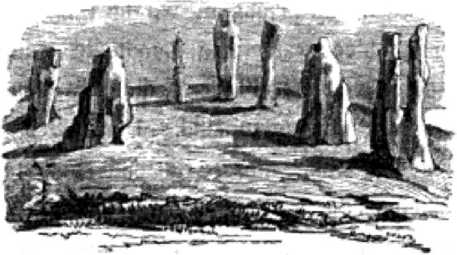
Geological and geographical research continued along the Pechora and Ilych Rivers. Here, for the first time, outcrops of ancient crystalline rocks were found and the deposits of the Lower (now Ordovician) and Upper Silurian, Devonian and Carboniferous were described faunistically. Going down the Pechora River on boats, expedition members surveyed the river and examined coastal outcrops. On the Soplesk River, known for a long time for grindstone mining, Keyserling described and first sketched the structure of the deposit [8]. Next, the expedition headed to the sources of the Pechora River, to the Bolvano-Iz site.
Balvaao is (Gulzenberg der Manlschi).
Fig. 3. Sketch of Bolvano-Iz from the work of A.A. Keyserling [1].
A.A. Keyserling noted that the rocks forming the pillars are represented by quartz-chlorite schists, and their formation is associated with weathering processes (Fig. 3). The height of the shortest pillar is 87 fathoms and it is assumed that the other pillars are more than 100 fathoms high. Today, these objects are the geological monument Manpupuner, the second name is “Bol-vano-Iz”. This complex is represented by seven remnants with a height of 30 to 42 m.
From the mouth of the river Shchugor in the eastern direction they went to the Ural Ridge. A.A. Keyserling gave a brief description of the rocks of the Saber Ridge: “This ridge, rising about 4000 feet above a marshy, squat terrain formed from fragments of coal shale clay and coarse sandstones, consists of porphyritic breccias, completely indistinguishable from the Solomenskiy stone near Petrozavodsk” [9, p. 155]. In the structure of the Ural Ridge, A.A. Keyserling identified various zones, extending from south to north: the zone of red sandstones with sandstones of Carboniferous age; the absence of Permian deposits for the studied area; limestone zone; Silurian zone, forming the western central mountain range of the Urals; zone of crystalline chlorites and mica schists, composing the main ridge of the Urals.
On July 24, they stopped at the village of Troitskoe and continued down the entire Pechora River to its lower reaches. The descent was accompanied by a precise description of the shores, islands and the river, specifying its length. Having reached the Timan tundra, the scientists carried out further research over a length of 600 miles on sleds with reindeer. A.A. Keyserling described the crystalline rocks of Cape Barmin, Silurian limestones, Devonian sandstones and basalts. He found out that the edge of a low but wide (about 65 km) cliff ridge in the north had been explored.
A.A. Keyserling found similarities with pink granites of Scandinavia in the structure of the northern part of Timan on the shore of the Arctic Ocean. Geologically, he identified crystalline schists with intrusive diorites on Cape Barmin and clay and mica shales in the coastal area along the Kaninskiy Peninsula. Similar shales were traced along the Vol River and in the upper reaches of the Vychegda River.
On the Vashkina River, near the Arctic Sea, shells of the brachiopods Pentamerida, Cythtri-na, as well as numerous Silurian corals Calenipora labyrinthica, Calamopora alveolaris and stroma-toporates Stromatopora concenlrica, etc. were discovered [1].
Outcrops of coal-bearing limestone with fusulinids up to 100 feet high have been described along the banks of the Indiga River. Further, similar outcrops were found along the banks of the Tsilma River, in the southern parts of the ridge along the banks of the Vol, Yuzhnaya Mylva and Vychegda Rivers.
Outcrops of Permian age were found in the eastern part of the ridge and limestone and gypsum — in the western part. Large accumulations of gypsum were found in the upper reaches of the Vym River, and limestones of Permian age with brachiopods Productus sapsinii were found on the Ukhta and Vychegda Rivers.
Based on the collected geological materials, A.A. Keyserling came to the conclusion that this ridge, like the hills on the Vol River, belongs “to a hitherto unknown uplift system... due to its insignificant height, noticeable only in the treeless tundra”. A.A. Keyserling called this upland the Timan Ridge (from the local collective name) and estimated its length at 800 km [1, p. 236].
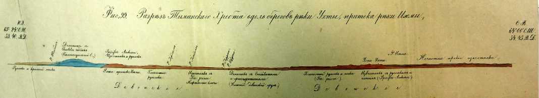
Fig. 4. Section of the Timan Ridge, constructed by A.A. Keyserling, from the Collection of geological maps [3].
Having crossed the Indiga River, on August 31, the expedition returned to the village of Oksina and visited the village of Pustozersk. The route then passed along the Pechora and Izhma rivers to the mouth of the Ukhta River, where the first scientific description of the Ukhta oilbearing area was made. A special place in the description is given to the “domaniks” on the Ukhta River. According to the description made by A.A. Keyserling, they consist of interbedded shales saturated with oil and fossil remains. They contain “long and thin” orthoceratites, goniatites, mollusks, and brachiopods. The identified species of fossil animals were first discovered in Russia and proved that the Domanik rocks are a new formation of the Lower Devonian. A.A. Keyserling gives a thorough description and carries out measurements on self-flowing oil objects on the Ukhta and Chut rivers. It is also indicated that local residents use these rocks as raw material for stone products. Mention is made of the use of “mountain oil” both from rocks and obtained by distillation from domanik in the form of a skin lubricant for sharpening metal products, as well as for external application in case of diseases.
A.A. Keyserling paid special attention to the rocks of the Jurassic system, which are widely spread on the Pechora plate. The abundance of belemnite species, small molluscs of the genus Avicula, and orthoceratites is noted. The Jurassic rocks exposed at the confluence of the Pechora and Izhma rivers are described in the most detail. In his first publication, A.A. Keyserling gives a description of 52 specimens of ammonoids collected by him from the Domanik shales (Upper Devonian) [10]. He assigned them to the genus Goniatites and described eight species, including four new ones — G. ammon, G. strangulatus, G. bisulcatus, G. uchtensis, currently belonging to differ- ent genera. In a generalizing work of 1846, A.A. Keyserling gives a description of fossil molluscs, including cephalopods. He characterized nine species of Jurassic ammonites, including new ones — Ammonites Ishmae (now a type of the genus Arcticoceras ishmae), characteristic of the “lowest Jurassic layers” (Lower Bathonian) and two new species of Early Cretaceous (Valanginian) ammonites — Ammonites polyptychus and Am. diptychus (now in the genus Polyptychites) [11].
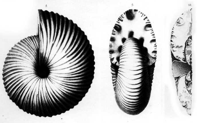
Fig. 5. Ammonites Ishmae from the work of A. A. Keyserling [10].
The stone material collected by A.A. Keyserling was repeatedly studied by other outstanding scientists. Thus, a new species of fossil fish Coccosteus obtusa was discovered by the naturalist and paleontologist Christian Pander in the samples brought by A.A. Keyserling from the outcrop of the Ukhta River [2, p. 302]. However, the most interesting discovery was made by A.A. Keyserling in the Jurassic sediments along the Vizinga River, a tributary of the Sysola River. He discovered the rib of a “large lizard-like creature”. Later, this find was passed to Professor Richard Owen, who determined that the fossil remains belonged to the species Plesiosaurus brachyspondylus Owen [1].
In Ust-Ukhta, the expedition split up. On September 17, A.A. Keyserling reached the Vym river through the Ukhta volok. Wash it out. Surveying the river banks, he discovered layers of white gypsum in the dolomite limestones. Then the route continued to the Vychegda River to the town of Ust-Sysolsk. On September 27, A.A. Keyserling visited the village of Seregovo, where he made geognostic observations. He studied limestone outcrops and drilled boreholes 94 fathoms deep (about 172 m). P.I. Krusenshtern went to Ust-Sysolsk by another route — through the upper reaches of the rivers Izhma, Cher Izhemskaya and Cher Vychegodskaya, Vychegda.
In 1844, A.A. Keyserling was awarded the Order of St. Vladimir of the 4th degree for the success of the expedition. The results of the expedition were presented in the book “Wissen-schaftlihe. Beobachtungen auf einer Reise in das Petschora-Land, im Jahre 1843” “Scientific observations during a trip to the Pechora region in 1843”, published in St. Petersburg in 1846 [1]. In 1847, the authors were awarded the Demidov Prize for this work.
Conclusion
The description of this expedition and the collected geological material from the territory of European Russia became the basis for further geological research in the 19th–20th centuries. Geological and paleontological research by A.A. Keyserling made it possible to compile the first reliable geological map of the Pechora Krai with the Timan Ridge. Keyserling showed the presence of Devonian, Jurassic and Lower Cretaceous sediments in the Pechora Krai with paleontological substantiation. Important geological conclusions include the identification of rocks of Lower Silurian age. F.N. Chernyshev, who studied the geological structure of the Timan Ridge in 1889–1890, appreciated the contribution of A.A. Keyserling in identifying the mountain structure and confirmed its (the ridge’s) extension from the upper reaches of the Vychegda River to the coast of the Arctic Ocean [12]. D.N. Sokolov (1867–1919), geologist and paleontologist, after studying the collection of A.A. Keyserling notes: “The fauna of the Pechora Jurassic, including ammonites, is described in detail in the works of Count Keyserling Wissenschaftliche Beobachtungen auf einer Reise in das Petschoraland (1846). Characteristics of ammonites on clarity and accuracy of descriptions, in the absence of verbosity, can be considered exemplary” [13, p. 1].
P.I. Krusenshtern compiled a geographical map on a scale of 1:3000000 with a rectangular geographic grid and detailed mapping of rivers, lakes and settlements. In addition to repeating the astronomical observations of V.K. Vishnevskiy, P.I. Krusenstern determined the coordinates of 47 new settlements. In the work, he describes the waterways used by the locals for trade purposes. The busiest waterway was from the Kama River through the Vishera, Kolva, Visherka rivers, through the Chusovoe Lake, to the Berezovka, Vogula rivers, and then by drag to the Volosnitsa River, which flows into the Pechora. Cherdyn merchants crossed this route, delivering grain from the Volga region to the Pechora Krai. The upper Vychegda River had two waterways, but there was not always enough water in the river in summer, so they were only suitable for small navigable boats. P.P. Krusenshtern mentions the Poshegodskaya and Bolshaya Pechora crossings. A description of 46 main rivers and small tributaries was made. In order to supply timber by water, P.P. Krusenshtern focuses on measuring the depth of the Indigskaya Bay, as well as a thorough study of the communication of the Pechora River with the Indiga River.
Along with a detailed hydrographic description, information about the forests growing on the river banks, fishing, hunting and other economic activities of the local population was collected. As a result of the expedition, the main minerals used by local people for mining (salt, grindstone, domanik, oil) were described; coal on the Soples River, gypsum on the Vym and Pechora Pizhma rivers, copper ore outcrops on the Mutnaya River, flint outcrops on the tributaries of the Vychegda were discovered for the first time.
Subsequently, A.A. Keyserling never returned to the Pechora Krai, but continued his scientific activity. He was elected an honorable member and corresponding member of many Russian and foreign scientific societies.
P.I. Krusenshtern connected his life with the Pechora Krai, conducting not only scientific research, but also engaging in industrial activities. Together with M.K. Sidorov and V.N. Latkin, he was engaged in harvesting and exporting larch mast timber to Russia and abroad. The main problem solved by P.I. Krusenshtern was to build waterways from the Pechora Krai to Siberia and Europe, both through the Pechora River to the Ob River and along the Kara and Barents seas [14].
References Geological and Geographical Expedition of A.A. Keyserling and P.I. Krusenstern to the European North-East of Russia
- Keyserling A., Krusenstern P. Wissenschaftliche Beobachtungen auf einer Reise in das Petschora-Land, im Jahre 1843. Saint Petersburg, 1846, 465 s.
- Murchison R.I., Verneyl' E., Keyzerling A.A. Geologicheskoe opisanie Evropeyskoy Rossii i khrebta Ural'skogo. Ch. 1 [Geological Description of European Russia and the Ural Ridge. Part 1]. Saint Pe-tersburg, I. Glazunov i Ko Publ., 1849, 1141 p. (In Russ.)
- Murchison R.I. Sbornik geologicheskikh kart, obnazheniy i razrezov, prinadlezhashchikh k «Geolog-icheskomu opisaniyu Evropeyskoy Rossii i khrebta Ural'skogo», sostavlennomu na osnovanii na-blyudeniy R.I. Murchisona, E. Vernelya i grafa A. Keyzerlinga [Collection of Geological Maps, Out-crops and Sections Belonging to the "Geological Description of European Russia and the Ural Ridge", Compiled on the Basis of Observations by R.I. Murchison, E. Vernel and Count A. Keyserling]. Saint Petersburg, 1849, 17 p. (In Russ.)
- Molchanov K.S. Opisanie Arkhangel'skoy gubernii, eya gorodov i dostoprimechatel'nykh mest so mnogimi drevnimi istoricheskimi izvestiyami i zamechaniyami, k dopolneniyu Rossiyskoy Istorii slu-zhashchimi [Description of Arkhangelsk Province, Its Towns and Places of Interest with Many An-cient Historical Data and Remarks, Serving to Supplement Russian History]. Saint Petersburg, Impe-ratorskaya Akademiya Nauk Publ., 1813, 319 p. (In Russ.)
- Brusilov N. Opyt opisaniya Vologodskoy gubernii [The Experience of Describing Vologda Province]. Saint Petersburg, 1833, 64 p. (In Russ.)
- Silin V.I. Geograficheskie issledovaniya na territorii Komi kraya v kontse XVIII — nachale XX vv.: monografiya [Geographical Studies on the Territory of the Komi Region at the End of the 18th - Be-ginning of the 20th Centuries]. Syktyvkar, 2019, 212 p. (In Russ.)
- Filippova T.G. Dokumental'nye svidetel'stva o pervoy geologicheskoy ekspeditsii na Evropeyskiy Severo-Vostok Rossii pod rukovodstvom A.A. Keyzerlinga v 1843 g. [Documentary Evidence of the First Geological Expedition to the European North-East of Russia Under the Leadership of A.A. Key-serling in 1843]. In: Materialy mezhdunarodnoy konferentsii rossiyskogo natsional'nogo komiteta po istorii i filosofii nauki i tekhniki RAN [Proc. Intern. Conf. Russian National Committee on History and Philosophy of Science and Technology RAS]. Moscow, 2022, pp. 322–325. (In Russ.)
- Astakhova I.S. Pervaya nauchnaya ekspeditsiya v Pechorskiy kray [The First Scientific Expedition to the Pechora Region]. In: Mineral'no-syr'evye resursy arkticheskikh territoriy Respubliki Komi i Ne-netskogo avtonomnogo okruga: materialy nauchno-prakticheskogo soveshchaniya [Mineral Re-sources of the Arctic Territories of the Komi Republic and the Nenets Autonomous District: Proc. Sci. and Pract. Meeting]. Syktyvkar, Geoprint Publ., 2016, pp. 13–15. (In Russ.)
- Murchison R.I., Verneyl' E., Keyzerling A.A. Geologicheskoe opisanie Evropeyskoy Rossii i khrebta Ural'skogo. Ch. 2 [Geological Description of European Russia and the Ural Ridge. Part 2]. Saint Pe-tersburg, I. Glazunov i Ko Publ., 1849, 669 p. (In Russ.)
- Keyserling A. Beschreibungen einiger Goniatiten aus dem Domanikschifer. Saint Petersburg, 1844, 26 s.
- Starodubtseva I.A. A.A. Keyzerling ‒ odin iz pervykh otechestvennykh issledovateley iskopaemykh tsefalopod (k 200-letiyu so dnya rozhdeniya) [Keyserling - One of the First Domestic Researchers of Fossil Cephalopods (On the 200th Anniversary of his Birth)]. In: Contributions to Current Cephalopod Research: Morphology, Systematics, Evolution, Ecology and Biostratygraphy. Moscow, 2015, iss. 4, pp. 9–11. (In Russ.)
- Chernyshov F.N. Orograficheskiy ocherk Timana: s geologicheskoy kartoy na trekh listakh, 12 tablitsami i 6 risunkami v tekste [Orographic Sketch of Timan: With a Geological Map on Three Sheets, 12 Tables and Six Figures in the Text]. Proceedings of the Geological Committee, 1915, vol. 12, no. 1, 136 p.
- Sokolov D.N. K ammonitovoy faune Pechorskoy yury [To the Ammonite Fauna of the Pechora Juras-sic]. Proceedings of the Geological Committee, 1912, iss. 76, 65 p.
- Kruzenshtern P.I. Puteshestviya P.I. Kruzenshterna k Severnomu Uralu v 1874—1876 godakh. Dlya issledovaniya vodyanogo soobshcheniya mezhdu pritokami Pechory i Obi [Voyages of P.I. Krusen-stern to the Northern Urals in 1874-1876. To Investigate the Water Communication Between the Pechora and Ob Tributaries]. Saint Petersburg, 1879, 172 p. (In Russ.)
