Habitation layers and pedogenic processes in forest-steppe Riverine valleys west of the don: the case of Ilyinka

Author: Fedyunin I.V., Merkulov A.N., Goleusov P.V., Sarapulkin V.A.
Journal: Archaeology, Ethnology & Anthropology of Eurasia @journal-aeae-en
Section: Paleoenvironment, the stone age
Article in issue: 2 т.44, 2016.
Free access
Short address: https://sciup.org/145145263
IDR: 145145263 | DOI: 10.17746/1563-0110.2016.44.2.056-068
Text of the article Habitation layers and pedogenic processes in forest-steppe Riverine valleys west of the don: the case of Ilyinka
The Ilyinka site was revealed by one of the authors of this article in 2012 and subjected to excavations in 2013 (Fedyunin, 2013, 2014). The site is located on the right bank of a stream, near its mouth, at the western extremity of the sub-triangular cape (an erosional remnant of the ancient second bottom) of the right bank of the Tikhaya Sosna River (the maximum height above the modern floodplain is 2.5 m); this has the latitudinal exposure near the Mukhouderovka village in the Alexeyevsky District of the Belgorod Region (Fig. 1). The central part of the cape, where sediments are saturated with materials, is relatively flat ground, with slopes that gradually lower to the level of the modern floodplain. In the site’s neighborhood, the floodplain is spotted with chains of swamped and dried-up shallow oxbow lakes, immediately adjacent to the base of the cape. Possibly the site was located on the shore of a vast waterbody during the periods of the spring flood.
An excavation-area of 103 m2 established in the central part of the cape cut it in the meridional direction. Beyond the site’s limits, pedological studies were conducted, the results of which were correlated with the data from the excavation-area. A Mesolithic habitation layer was traced therein; rare household finds belonging to the Bronze Age, the Early Iron Age, the Middle Ages, and the Modern Period were distributed in a random manner without forming any spatially separate structures. A single medieval burial has been encountered. Thus, several localities attributed to different times, and the burial, are combined within the framework of this site.
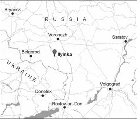
Fig. 1. Location of the Ilyinka site.
Soil morphology and the issues of site stratigraphy
The results of studies carried out in different sections of the site in 2013 allow a sufficiently comprehensive reconstruction of the relationship between lithologic and stratigraphic data. Accordingly, since the difference in thickness of deposits above bedrock is negligible, it is possible to use the “averaged” data over all available excavation-areas and extensions, taking into account their local features.
Below, a morphological description of the profile is given (Fig. 2).
A0 (0–1 cm)
Аv, tr (0–5 cm)
АU (5–27 cm)
Steppe mat, predominantly grass opal.
Soddy horizon, penetrated by roots, lighter in color compared to the underlying one, heterogeneous, structureless, with signs of mechanical disturbance; smooth boundary.
Dark gray, uniform in color, packed; having granular-silty structure in the upper portion, and silty-structureless in the lower portion; undulating boundary,
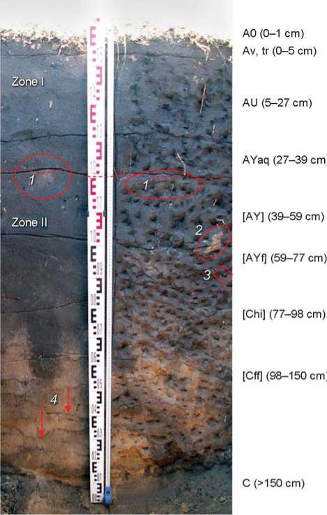
Fig. 2. Profile of site sediments (see description in the text).
1 – signs of mechanical disturbance; 2 – suffosion tongue; 3 – inclusion of flint flake; 4 – pseudofibres.
AYaq (27–39 cm)
[AY] (39–59 cm)
[AYf] (59–77 cm)
[Chi] (77–98 cm)
[Сff] (98–150 cm)
С (>150 cm)
transition is gradual in color; frequent roots, single molehills.
Gray, heterogeneous (with light spots), packed; crumbly slab-shaped structure with horizontal division predominant; some bedding is present; undulating boundary, gradual transition; rare roots.
Gray, heterogeneous (with light spots), with suffosion yellow-gray and gray-yellow tongues, packed, structureless; undulating boundary, transition is noticeable in color. The gray humus horizon of soil buried under alluvial deposit.
Gray, heterogeneous (with pale-yellow spots), packed, structureless, with rare ferruginous inclusions; turbic soil turned over by mole-rats in the lower part; undulating boundary, transition is noticeable in color.
Grayish-brown, very heterogeneous with humus tongues; closely-packed; turned over by mole-rats; pocket and tongue-like boundary; noticeable transition; frequent molehills and wormholes filled with
darker material compared to the enclosing
one.
Ochre-yellow, very heterogeneous (with gray spots), closely-packed with undulating veins less than 1 cm thick, cemented by organo-mineral colloids and iron oxides, and lying at intervals of approx. 10 cm; smooth boundary, gradual transition.
Gray-yellow ancient alluvial sand.
The soil is gray sabulous pseudofibrous unsaturated humus (after (Klassifikatsiya…, 2004: 237))* with the second buried profile on alluvial sediments. The soil shows traces of modern and, possibly, ancient anthropogenic profile-disruption. A succession of various pedogenic regimes caused by climatic and biotic changes is revealed. Light fragments of soil in the middle part of the stratum, which are not elaborated by humus accumulation, could be a result of mechanical impact on the profile. Suffosion-inclusions of sand alluvium bear evidence of episodic flooding. Certain bedding in the layer of 27–39 cm confirms the existence of an alluvial (sinlithogenic) pedogenesis phase, accompanied by accumulation of deposits in the past. In general, signs of alluvial profile stratification are feebly-marked, which suggests a predominance of automorphous
postlithogenic pedogenesis. The presence of brown interlayers (pseudofibers) is probably related to the period of climate-moistening and colonization of the area by tree vegetation, which ensured greater mobility of iron oxide and other mineral and organo-mineral colloids. Reaction with 10 % hydrochloric acid is absent throughout the entire stratum.
The profile exhibits two morphologically pronounced zones corresponding to the various stages of soilevolution.
Zone I is the upper part of the profile. The soil formed on a thin alluvial deposit in steppe conditions has not experienced a considerable climatic change, and shows traces of surface mechanical (anthropogenic and zoogenic) disturbance. During initial development-stages, it has gone through a sinlithogenic pedogenesis phase (formation of humus horizon proceeded simultaneously with accumulation of deposits); however, it is fully automorphous at the present time.
Zone II is the lower part. It represents a polygenic profile of soil that has formed in steppe conditions, but experienced a change of climate to a more humid one in the past; the soil shows signs of differentiation caused by the forest pedogenesis phase, and also ones of mechanical disturbance and flooding.
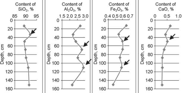
Below, the results of a bulk chemical analysis of soil material are given*. As a rule, light soils developing in steppe conditions have a profile which is poorly differentiated with respect to the content of chemical elements. By contrast, a number of abnormalities is observed in their distribution over horizons in the soil under study, which is confirmed by relatively high values of the variation coefficient (Table 1; Fig. 3, c ). The maximum content of silica corresponds to the alluvium accumulation zone. The distribution of SiO2 in the remaining part of the profile is regular. The maximum contents of CaO, K2O, P2O5 correspond to zone II of the profile, which confirms its presence. Accumulation of these elements is confined to the topsoil and, obviously, is of biogenic origin. Zone II has pronounced double maxima of Al2O3 and Fe2O3 content, which suggests the existence of a pedogenesis phase contributing to migration and redistribution of these elements. It is probably related to more humid climatic conditions, and the forest phase of soil development.
Generally, the distribution of microelements over the profile (see Table 2; Fig. 3, b ) confirms the regularities revealed by the analysis of the distribution of macroelements. Abnormalities are observed both in the topsoil and in the zone of pseudofibres—these pseudofibres being temporary aquicludes, and facilitating
*Sabulous leached chernozem (after (Klassifikatsiya…, 1977: 196)).
*The analysis was carried out by the X-ray fluorescence method, using the SPECTROSCAN Max-GV spectrometer.
Table 1. Contents of macroelements and their variation coefficient ( V ) in soil horizons
|
Horizon |
Depth, cm |
Zone of soil profile |
Contents of elements in terms of oxides, % |
||||||
|
SiO 2 |
Al 2 O 3 |
Fe 2 O 3 |
CaO |
K 2 O |
TiO 2 |
P 2 O 5 |
|||
|
АU |
5–27 |
I |
89.215 |
2.677 |
0.657 |
0.634 |
0.628 |
0.244 |
0.0816 |
|
AYaq |
27–39 |
92.006 |
2.202 |
0.547 |
0.436 |
0.535 |
0.216 |
0.0616 |
|
|
[AY] |
39–59 |
II |
89.438 |
2.383 |
0.600 |
0.512 |
0.568 |
0.232 |
0.0768 |
|
[AYf] |
59–77 |
89.764 |
2.781 |
0.603 |
0.371 |
0.626 |
0.236 |
0.0613 |
|
|
[Chi] |
77–98 |
90.142 |
2.513 |
0.564 |
0.302 |
0.556 |
0.217 |
0.0546 |
|
|
[Сff] |
98–150 |
91.126 |
2.880 |
0.588 |
0.299 |
0.571 |
0.240 |
0.0592 |
|
|
С |
>150 |
91.526 |
2.142 |
0.467 |
0.285 |
0.525 |
0.223 |
0.0647 |
|
|
V , % |
1.21 |
11.31 |
10.26 |
32.17 |
7.11 |
4.80 |
14.95 |
||
|
Content of Zn, mg/kg 0 10 20 30 _____J______L______J |
Content of Zr, mg/kg 50 100 150 |
Or га 4a e 6a |
Content of Ni, mg/kg ) 5 10 |
Content of Rb. mg/kg n0 5 10 15 |
C oi |
ontent of Y, mg/kg 9 10 |
||||
|
20 40 |
20 |
20 40 E 60 |
20 40 |
|||||||
|
4Qj |
||||||||||
|
O 60 |
о 60 |
о 60 f 8°- О 100 120 140 |
||||||||
|
К 80 О 100 120 140 |
||||||||||
|
/ |
||||||||||
b
Content of Content of
K2O, % P2O5, %
с
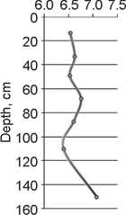
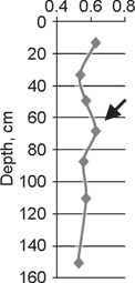
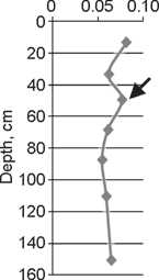
Fig. 3. Distribution of рН (Н 2 О) and some micro- and macro-elements over the soil profile (distribution abnormalities are marked by arrows).
concentration of microelements. Zinc and nickel that actively migrate in acidic media have formed two maxima, which could have been facilitated by forest pedogenesis conditions.
At present, the soil рН-profile is poorly differentiated (Fig. 3, а ), and the coefficient of variation is 3.30 %. The
reaction as a whole is slightly acidic and approaches to neutral with depth, which is, obviously, explained by the influence of slightly alkaline subsoil water. However, the рН minimum is observed at the depth of the pseudofibrous zone. This may be related to the accumulation of both aluminum and iron, which contributed to the formation
Table 2. Contents of certain macroelements and their variation coefficient ( V ) in soil horizons
|
Horizon |
Depth, cm |
Zone of soil profile |
Contents, mg/kg |
||||||||||
|
Ba |
Zr |
Cr |
V |
Zn |
Y |
Rb |
Cu |
Ni |
Co |
As |
|||
|
АU |
5–27 |
180.15 |
84.46 |
47.82 |
32.52 |
18.17 |
9.69 |
9.94 |
6.60 |
4.65 |
2.08 |
1,37 |
|
|
AYaq |
27–39 |
166.31 |
56.04 |
49.06 |
30.38 |
6.90 |
9.52 |
5.86 |
6.05 |
3.91 |
2.28 |
1,13 |
|
|
[AY] |
39–59 |
166.78 |
110.27 |
43.93 |
27.65 |
19.45 |
9.41 |
10.81 |
5.12 |
4.76 |
|
2,10 |
|
|
[AYf] |
59–77 |
166.11 |
97.49 |
50.14 |
30.10 |
8.23 |
9.84 |
10.10 |
5.42 |
2.46 |
|
2,75 |
|
|
[Chi] |
77–98 |
II |
147.97 |
84.01 |
41.72 |
20.55 |
9.50 |
9.27 |
6.39 |
|
3.49 |
4.76 |
2,44 |
|
[Сff] |
98–150 |
140.37 |
83.73 |
42.38 |
18.63 |
19.32 |
9.33 |
3.60 |
4.87 |
5.05 |
5.16 |
1,56 |
|
|
С |
>150 |
134.03 |
105.71 |
38.31 |
21.24 |
6.71 |
8.61 |
5.24 |
|
0.84 |
3.56 |
1,70 |
|
|
V , % |
10,65 |
20.37 |
9.74 |
21.63 |
47.90 |
4.21 |
38.05 |
12.56 |
41.91 |
39.21 |
31.50 |
||
*LLD – lower limit of detection.
of acidic media. At the depth of humus-accumulation horizon of zone II soil, the hydrogen values are currently close to their minimum. It is likely that earlier, during the forest development phase, the рН minimum was more pronounced here.
Correlation between the results of soil studies and archaeological stratigraphy of the site allows a few conclusions to be drawn. The soil provides an example of a complicated history of development. The succession of evolution can be reconstructed as follows: primitive sandy soil (psammozem) → gray humus soil under steppe vegetation → gray humus soil under forest vegetation → alluvial gray humus soil → gray humus soil under steppe vegetation. The determination of the duration of these stages is challenging. However, using the model of humus-horizon formation with time (Goleusov, Lisetsky, 2009: 123–131), it can be assumed that the last stage is no more than 2–2.5 thousand years; while the total duration of steppe pedogenesis is at least six thousand years. Taking into account the initial and forest pedogenesis stages, the soil’s age can hardly exceed eight thousand years. These estimates should be considered tentative, since alternating pedogenic-phases recorded in the soil-profile make dating within a single model difficult.
The gray sandy loam layer unearthed by the excavation increased to the east, possibly in line with the modern hypsometric marks on approaching the edge of highland. As might appear at first sight, the artifacts belonging to different epochs are laid randomly in the mass of cultural strata. However, an increase in concentration of finds is observed at a depth of approximately –50 cm from the datum-point, which corresponds to the boundary between zones I and II that have been distinguished in soil. Considering the synchronism of pedogenic processes and the subsidence of artifacts in the soil profile determined by them, it can be stated that
Mesolithic finds are confined to the primitive sandy soil, the relics of which can be located in zone II; while the materials of subsequent cultures are attributed to zone I. Burial of artifacts was also related to minor alluvial and aeolian sedimentation of fine earth. Therefore, the daylight surface level in the Mesolithic Age was lower than the modern one by 20–25 cm.
Mesolithic materials
Planigraphic placement of materials belonging to various epochs does not form clearly separated structures. Poor saturation with finds is characteristic of the entire unearthed area, while a certain increase in their concentration was recorded in the western section of the excavation-unit.
Analysis of localization of debitage and tools suggests that flint-knapping, manufacture of tools, and labor operations were carried out at the same places within the excavated area: for example, there are no accumulations of certain types of tools or blanks typical of long-term sites such as Plautino-2 (the lower stratum) (Fedyunin, 2012: 19). All the above confirms the status of the Mesolithic site as a short-term locality with poor cultural layer.
The vast majority of Mesolithic artifacts are made from cretaceous black flint. The nearest outcrops of raw materials in the form of small nodules are located in the chalk exposures near the bedrock coast of the Tikhaya Sosna River in the vicinity of Ilyinka; while higher-quality large raw materials are found to the south, on the slopes of ravines and gulches near the Tikhaya Sosna source, and in the Oskol River basin. In individual cases, attempts of knapping of local fissured brown tabular and greenish pebble flints of morainic origin were recorded.
In the course of studies, a collection of stone inventories composed of 284 specimens including 38 (13 %) tools (Table 3) has been obtained. Despite its meagerness, the collection documents the basic stages of flint-knapping and the manufacture of tools.
It comprises precores (Fig. 4, 1 ), prismatic and multi-platform cores (Fig. 4, 3 , 4 ; 5, 3 ), narrow-faced cores of tabular flint (Fig. 5, 1 ), and blades (see Fig. 4, 2 , 5–9 ; 5, 5 ). Among the last, there are single spalls produced by pressure-technique; or by percussion, using an intermediate tool. A giant flake made from pink granite has been found (see Fig. 5, 2 ).
The following have been encountered: blades with various localizations of marginal retouch (see Fig. 4, 10 , 11 ); a knife on flake (see Fig. 4, 12 ); scrapers, among which a group of end-scrapers (see Fig. 4, 15 ; 5, 6 ) and end-side-scrapers are most representative (see Fig. 4, 14 ); combination tools of endscraper-burin (see Fig. 4, 22 ); and reamer-burin combinations (see Fig. 5, 8 ).
End-scrapers retouched along 3/4 of the perimeter (see Fig. 4, 16 ; 5, 7 ) and ogival endscrapers (see Fig. 4, 13 ) are single. The majority of burins are shaped on the platforms of broken blanks (see Fig. 4, 19 , 20 ); dihedral, side, and combination burins (see Fig. 4, 21 ) are less frequent. Perforating-tools are few: apart from the above-mentioned reamer, there is a drill made on a long symmetric burin-spall with the working portion shaped by subparallel facets of flat retouch (see Fig. 5, 9 ).
Hunting-tools include: an asymmetric basal-notched point where the notch was produced by vertical unidirectional retouching of the edge (see Fig. 4, 24 ); an asymmetric arrowhead with a haft-element and an opposite edge marked by abrupt retouch, and with traces of point rejuvenation from the inverse surface (see Fig. 4, 25 ); a point with a micro-burin spall scar and the edge blunted by abrupt retouch (see Fig. 4, 26 ); and a symmetric average-high trapeze (see Fig. 5, 12 ).
The ensemble of tools is supplemented by a fragment of blade with bifacial semi-abrupt retouch, which occurred in the filling of the pit of medieval tomb 1 (see Fig. 5, 11 ), and an item on blade with the stemmed part marked by retouch and with a triangular end (see Fig. 5, 10 ). The purpose of the last one is unclear. Possibly it was used as a spoon-bait for fishing.
Generally, it may be noted that the flintknapping technique at the site was aimed at
Table 3. Stone tools from Ilyinka
|
Finds |
Amount |
% of the number of finds |
|
|
in collection |
in category |
||
|
Debitage |
|||
|
Precores |
3 |
1.1 |
1.2 |
|
Cores |
5 |
1.8 |
2.0 |
|
Longitudinal spalls |
2 |
0.7 |
0.8 |
|
Flint fragments |
10 |
3.5 |
4.1 |
|
Flakes |
117 |
41.2 |
47.6 |
|
Thermic chips |
6 |
2.1 |
2.4 |
|
Debris |
23 |
8.1 |
9.3 |
|
Chips |
31 |
10.9 |
12.6 |
|
Burin spalls |
3 |
1.1 |
1.2 |
|
Ribbed spalls |
3 |
1.1 |
1.2 |
|
Blades |
23 |
8.1 |
9.3 |
|
Proximal fragments of blades |
8 |
2.8 |
3.3 |
|
Medial fragments of blades |
9 |
3.2 |
3.7 |
|
Distal fragments of blades |
3 |
1.1 |
1.2 |
|
Total |
246 |
87 |
100 |
|
Tools |
|||
|
Retouched flakes |
4 |
1.4 |
10.5 |
|
End-scrapers |
3 |
1.1 |
7.9 |
|
end-side |
1 |
0.4 |
2.6 |
|
retouched along 3/4 |
2 |
0.7 |
5.3 |
|
ogival |
1 |
0.4 |
2.6 |
|
Burins on breaks |
8 |
2.8 |
21.1 |
|
dihedral asymmetric |
3 |
1.1 |
7.9 |
|
on oblique retouched truncation |
1 |
0.4 |
2.6 |
|
Retouched blades |
5 |
1.8 |
13.2 |
|
with ventral face thinning |
1 |
0.4 |
2.6 |
|
Points with a micro-burin spall scar |
1 |
0.4 |
2.6 |
|
basal-notched |
1 |
0.4 |
2.6 |
|
Fragments of points |
2 |
0.7 |
5.3 |
|
Trapezes |
1 |
0.4 |
2.6 |
|
Shouldered points |
1 |
0.4 |
2.6 |
|
“Spoon-bait” (?) |
1 |
0.4 |
2.6 |
|
Scaled pieces |
1 |
0.4 |
2.6 |
|
Drills |
1 |
0.4 |
2.6 |
|
Total |
38 |
13 |
100 |
|
Grand total |
284 |
100 |
100 |
5 cm
Fig. 4. Mesolithic stone industry (flint).
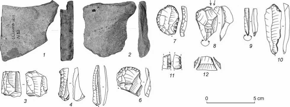
Fig. 5. Mesolithic stone industry ( 2 – granite, the remaining items – flint).
producing blades and flakes mainly by percussion flaking, while secondary working was dominated by various types of retouching and burin spalls.
Medieval burial materials
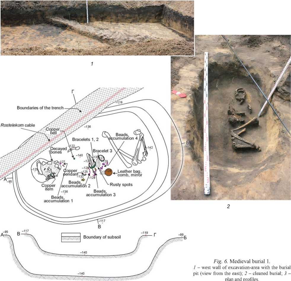
The pit of tomb 1, revealed in the course of subsoil cleaning, extended to the west wall of the excavation-area (Fig. 6, 1), because of which a western excavation extension of 1 × 2 m was made over it. The burial-pit had a rectangular shape with rounded corners, dimensions of 1.85 × 1.20 m, and a depth up to 0.5 m, and was oriented along the northeast– southwest direction, with small deviation of the western boundary to the north (Fig. 6, 2, 3). Its fill was represented by redeposited dark humic sandy loam, with light-yellow patches from the overlying deposits. The upper boundary of the pit was not recorded in the deposits above bedrock, owing to soil processes that are common in the Black Earth Region, and because of layer-destruction. Nevertheless, judging by the fill’s composition, it can be assumed that it was introduced just below the modern soil-level. The pit’s walls are vertical, the transition to the bottom near its eastern edge is more slightly sloping.
Strongly-fragmented skeletal remains of a 35–40-year-old woman (according to the definition given by
Boundaries of the trench
Bracelets 1, 2
Bracelet 3
iones
Rusty spots
-",
Beads, ^cumulation 4
Beads, accumulation 1
Beads^V /accumulation 2
Leather bag, comb, mirror
Beads, accumulation 3
Copper item
Rostelekom cable / ' Copper.
Fig. 6. Medieval burial 1 .
1 – west wall of excavation-area with the burial pit (view from the east); 2 – cleaned burial; 3 – plan and profiles.
-119
Boundary of subsoil
E.M. Makarova*), buried in a flexed position on her right side, with legs pulled up, were located on the bottom of the pit; a left arm-bone lay just above the pelvis (Fig. 6, 2 , 3 ). Unfortunately, the preservation of the boneremains left something to be desired: ossicles of the feet and hands, right arm, and thigh bones were absent, and the skull was largely destroyed. Conspicuous is the fact that the place taken by the skeleton is considerably smaller than the burial pit.
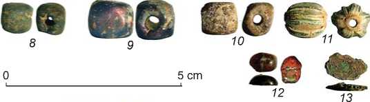
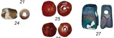
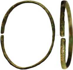
The grave goods are rich and varied (Fig. 7–9). It appears that a copper bracelet (see Fig. 7, 47 ) was put on the right hand of the buried woman; and two similar bracelets fastened by organic (leather?) material, which made a mark on the oxidized surface (see Fig. 8, 1 , 2 ), were on her left hand. An abundant collection of beads was localized in the form of accumulations (see Fig. 6, 3 ) adjacent to the lower jaw (accumulation 1; see Fig. 7, 1–12 ), slightly west of left forearm bones (accumulation 2; see Fig. 7, 14–34 ), adjacent to the left hand (accumulation 3; see Fig. 7, 35 , 36 , 38–46 ; Fig. 9) and right (?) hand (accumulation 4; see Fig. 8, 4–10 , 12–14 ). A small copper bell (see Fig. 7, 37 ) has been found near the vertebral column; a copper pendant (see Fig. 8, 3 ) was located
•ее б<вее
45^^^ ^~ д^"' ‘ '^^^^
4 56
ооОО оо «ОО
14 15 16 17
1^16
37 ^
^ ее СЭ0
40 4142
JO ее ио ®“
43 44 4546
00<ЮООО
18 19 20
О© 29
22 23
О& 33
Fig. 7. Grave goods from tomb 1.
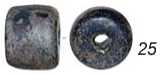
1–12 – beads from accumulation 1; 13 – copper item; 14–34 – beads from accumulation 2; 35, 36, 38–46 – beads from accumulation 3;
37 – small copper bell; 47 – bracelet 3.

just above the left arm-bones; a decayed leather bag (see Fig. 8, 11 ) that contained a wooden comb (see Fig. 8, 15 ) and a bronze mirror (see Fig. 8, 16 ) have been discovered adjacent to the hands.
The collection of beads from accumulation 1 includes the following types:
– Paste, ovoid, brown with a white horizontal stripe (type 34* (Pletneva, 1989: Fig. 64)) – 1 piece;
– Cornelian, spherical (59 (Ibid.: Fig. 66)) – 1 piece;
– Glass, one-segmented, with a metal gasket (20 (Ibid.: Fig. 62)) – 1 piece;
– Paste, 14-sided (10 (Ibid.)) – 2 pieces (patinated); and
– Paste, spherical, striped, two-colored (31 (Ibid.: Fig. 65)) – 1 piece (white-blue).
Flattened seed beads: blue (1 piece), green (1 piece), and patinated of indeterminate color (2 pieces); spherical, brown (1 piece).
Also, a fragmented small bell or a copper pressed spherical button with a wire loop (see Fig. 7, 37 ) has been found nearby (type 3 (Ibid.: Fig. 56)).
The beads from accumulation 2 represent the following types:
– Paste, spherical, blue – 1 piece;
– Paste, ovoid, brown with a white horizontal stripe (type 34 (Ibid.: Fig. 64)) – 4 pieces;
– Cornelian, ovoid (60 (Ibid.: Fig. 66)) – 1 piece;
– Cornelian, spherical (59 (Ibid.) – 3 pieces;
– Glass, one-segmented, with a metal gasket (20 (Ibid.: Fig. 62)) – 1 piece;
– Glass, multi-segmented, with a metal gasket (21 (Ibid.)) – 1 piece;
– Paste, rectangular, flattened, blue (13 (Ibid.)) – 1 piece; and
– Paste, ovoid, flattened, brown – 1 piece.
Flattened seed beads: paste, patinated, indeterminate color (4 pieces) and blue (3 pieces).
The following types of beads are represented in the most abundant accumulation 3:
Fig. 8. Grave goods from tomb 1.
1 , 2 – bracelets 1, 2; 3 – copper pendant; 4–10 , 12–14 – beads and seed beads, accumulation 4; 11 – decayed leather bag; 15 – wooden comb; 16 – bronze mirror.
– Paste, 14-sided (10 (Ibid.)): patinated – 10 pieces, blue – 7 pieces, violet – 1 piece;
– Paste, spherical (1 (Ibid.)): blue – 1 piece; light-blue – 2 pieces, brown – 1 piece, patinated, indeterminate color – 2 pieces;
– Paste, spherical, “eye” beads (24 (Ibid.: Fig. 65)); blue with blue-white eyes – 24 pieces; yellow with dark-and light-green eyes – 5 pieces;
– Paste, spherical, striped-eye (30 (Ibid.)) – 3 pieces: blue and light-blue beads with white stripes and ochre-white eyes, a green bead with yellow stripes and frequent eyes;
– Paste, spherical, striped, two-colored (31 (Ibid.)) – 1 piece (white-brown);
– Paste, cylindrical, with vertical stripes (37 (Ibid.: Fig. 62)) – 3 pieces: a blue bead with narrow red-white stripes, a blue bead with wide yellow and narrow white stripes, and a patinated one of indeterminate color;
– Paste, cylindrical, green, with narrow red, white, and green horizontal stripes;
– Paste, cylindrical, one-colored (3 (Ibid.)) – 1 piece (blue);
– Paste, ovoid, one-colored (2 (Ibid.)) – 3 pieces (blue, light-blue, and white); and
– Paste, drop-shaped, blue, with the surface covered by grooves.
Accumulation 4 includes beads of four types:
– Paste, 14-sided (10 (Ibid.: Fig. 62)): patinated – 5 pieces, blue – 1 piece;
– Paste, spherical (1 (Ibid.)), indeterminate color – 1 piece;
– Paste, spherical, “eye” beads (24 (Ibid.: Fig. 65)), blue with blue-white eyes – 2 pieces; and
– Paste, ovoid, one-colored, ribbed (8 (Ibid.: Fig. 62)) – 1 piece (blue).
Bracelets 1 and 2 (see Fig. 8, 1 , 2 ) are made of bronze braid with round cross-section and have flattened ends (view 2, type 3 (Ibid.: Fig. 60)). Bracelet 3 (see Fig. 7, 47 ) is bronze, twisted, with the ends bent to form loops (view 1, type 3 (Ibid.)). The mirror is made of white bronze by casting (see Fig. 8, 16 ). The loop is located at the center of the reverse side. The ornament is zigzag-shaped (view 1, type 4 (Ibid.: 100)). The copper cylindrical pendant had a ring-shaped fastening (see Fig. 8, 3 ). A wooden comb decorated with circular ornament along the edge and in the middle of its long axis is a unique find (see Fig. 8, 15 ). It had a rectangular
1 ^в^в 2 ®0 3 @© 4
-) ^ 5 во 6 4 3 7 ^B D 8 44 9 SO 10 ^@ 11 & © 12
@© 13 © 14
IJ ^ 15 64 16 44 17 64 18 0© 19 (foO 20 ^1^ 21 44 22 60 23 oo 24
®o 26 ®G 27
В
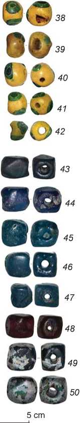
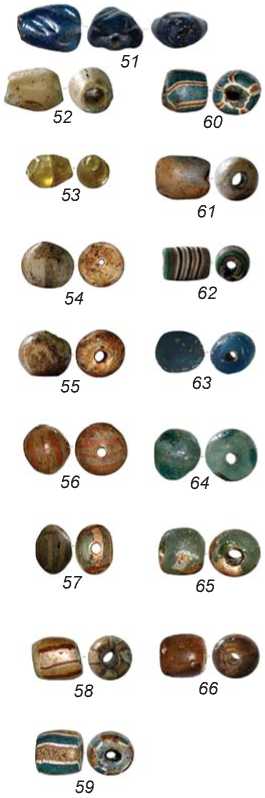
Fig. 9. Beads from accumulation 3.
shape and two opposite rows of cogs, coarse and fine. It is difficult to restore the original shape of the leather bag that contained the mirror and the comb: only the roundish portion that contacted the mirror (owing to which it is preserved) has remained of it (see Fig. 8, 11 ). Among the indeterminate items, we note a fragment of a copper artifact (see Fig. 7, 13 ). In addition, a rusty spot that has obviously remained from some unpreserved iron item has been found near the waist of the buried woman.
Conclusions
The above-described complex of Ilyinka finds attributed to different times is unique, owing to a small number of impressive Mesolithic and medieval sites in the foreststeppe region West of the Don, the study of which has holistic character. The coupled analysis conducted, of the soil and the material culture’s evolution, allows the correlation of the Mesolithic layer accumulation time with zone II of the soil-profile (39–150 cm from the surface; the synchronous soil is primitive sandy soil (psammozem)), and the correlation of the periods of appearance of materials belonging to the Bronze Age, the Early Iron Age, the Middle Ages, and the Modern Period with zone I (the upper part of the section (0–39 cm from the surface), which represents the modern stage of steppe pedogenesis, or gray humus steppe soil). The finds associated with this zone are rare and unimpressive. The early stage of pedogenesis is marked by predominantly steppe conditions alternating with arboreal phases; whereas at the late stage, the only landscape was steppe. Thus, a successive interchange of material culture chronotypes of the ancient population occurred mainly during the steppe phases of the natural environment’s development in the forest-steppe region on the right bank of the Don. Despite the instability of the “palimpsest” pedological record on the sandy substratum, automorphous soils can be helpful for environmental and cultural reconstructions of relationships in the “man-nature” system in the riverine valleys of the studied territory.
The issue of the cultural status of Mesolithic materials is a complicated one. Ukrainian researchers attribute similar complexes with or without ceramicware to different stages of the so-called Donets culture. However, the proposed models of its genesis (Gorelik, 1984, 1997) seem to be debatable even because of the very fact of using the “contact” model of formation of the archaeological cultures. The assumption of mechanical mixing of various cultural materials was not considered by A.F. Gorelik, though it is exactly this hypothesis that can explain the Donets culture’s “syncretism”, the specific archaeological expression of which is the predominance of mixed complexes comprising Zimovniki, Yanislavitsy, Kukrek (?), and Matveyev Kurgan (Grebeniki) antiquities among its sites. The source-base for distinguishing the Donets culture is poor; it is dominated by materials from destroyed camp sites and collections, and from soft alluvial deposits. This is exactly why investigations of short-term sites, “single-cultural” or with insignificant amount of admixtures, with due regard for the orographic context of their location, are of major importance for Mesolithic studies in the regions West of the Don.
The above characteristics of stone tools from Ilyinka are inherent in several archaeological cultures, the materials of which, most likely, were subjected to mechanical mixing. An asymmetric arrowhead and a point treated by vertical retouch cutting off the blank edge look like foreign elements against the background of the basic assemblage. Possibly these finds are more ancient. Such an assumption can be supported to some extent by the episodes of steppe-landscape differentiation, which were recorded in soil, caused by increasing humidity of climate, that could have resulted in a change of traditional hunting areas as well. Assemblages similar to the abovementioned were earlier obtained in the course of studying the neighboring areas in the Chernaya Kalitva River basin (south of the Voronezh Region) (Fedyunin, 2010: 145–148).
Concerning the economic specificity of the studied Mesolithic materials, it should be noted that the predominance of tools (burins) intended for treatment of bones and hunting-weapons points to the connection of the site with hunting and, possibly, with fishing.
The accompanying goods of tomb 1 are typical of the Saltovo-Mayaki culture of the Early Middle Ages. The available finds do not allow dating of the site to a narrower period than the chronological framework of the culture in general (the middle of the 8th century to the beginning of the 10th century). An elongated burial pit, in combination with the western orientation of the deceased, is peculiar to the majority of burial grounds of the Saltovo-Mayaki culture steppe variants, which are traditionally attributed as Bulgarian. The flexed position of buried women is typical of some catacomb burial grounds in the Don forest-steppe region that are reasonably associated with the Alans. The combination of the pit structure of the graves and the flexed position of the buried people is rather uncommon in the materials of burial sites attributable to the Khazar period.
We can find the most comprehensive analogs of the Ilyinka site in the Mayaki complex: tombs 5, 6 at the ancient settlement, and burials 111, 126 at the burial ground (Flerov, 1993: 121). Women were buried there in a flexed position on their left or right side, with their heads aimed towards the western sector, and were accompanied by a rich set of adornments and personalcare items, with an almost complete absence of ceramics. Whereas, in contrast to the Mayaki complex burials, no traces of coffins have been recorded in Ilyinka; which can be related to specific features of the ground, since sandy soils are not favorable for preservation of unprocessed timber.
In general, the rite according to which the female burials in the pits were performed at the Saltovo-Mayaki sites in the Tikhaya Sosna River valley are closer to the Alanian tradition than to the Bulgarian one. Only the most general traits, such as the burial pit and western orientation of the deceased, relate them to the Bulgarian tradition. Both of them were widespread among various ethnic groups that inhabited Eastern Europe in the Early Middle Ages. The Alanian tradition is represented by less widespread traits, including the posture of buried people according to their sex, and the composition of grave goods. The presence of similar burials in the Northern Caucasus (Albegova, Vereshchinsky-Babailov, 2010: 113–114) also argues for attribution to the Alans.
