In the ice of the 40th meridian (the research of the death in the arctic expe-dition of G. L. Brusilov)
")
Author: Zobnin A.N.
Journal: Arctic and North @arctic-and-north
Section: History
Article in issue: 6, 2012.
Free access
In the article gives a refutation of the generally accepted versions of the fate of the thirteen members of the expedition Brusilov, remaining on board the schooner “St. Anna” after the departure of the navigator Albanov V. A., in April 1914. For the first time, gathered together on the basis of available historical and geographical sources of currents, winds and drifting ice in the Arctic in a particular area, showing the most probable direction of the drift of the schooner, the reasons for its demise and the subsequent path of G. Brusilov expedition to the eastern coast of Svalbard.
Expedition, boat, ice, wind, drift, parallel, meridian, northern, Arctic, “Saint Anna”, Brusilov, schooner, Albanov, “Jeanette”, latitude, shelf, trans arctic, De long, Spizbergen, The land of Franz Iosif
Short address: https://sciup.org/148320456
IDR: 148320456 | UDC: 910.4
Text of the scientific article In the ice of the 40th meridian (the research of the death in the arctic expe-dition of G. L. Brusilov)
April 10, 1912 Nicholas embankment in St. Petersburg was filled with people. At 3:00 pm 55 minutes was a loud "hurray!" Resounded over the Neva. Motor-sailing barkentine "St. Anna" is slowly moved away from the mooring drums ... Thus began the tragical history of the polar expedition of Lieutenant GL Brusilov».
A hundred years later, and the death of 9 people of the group of Albanov, who left the schooner in April 1914, and the complete disappearance of the vessel with the remaining thirteen crew members on board and have remained a mystery.
Many versions put forward during this time, unfortunately, are based on one unsubstantiated assumption, which is completely ingrained in the national literature. Referring to the forums mate Albanov, researchers agree that the schooner must necessarily drift to the east coast of Greenland, with access to open water, somewhere near the island of Jan Mayen in the summer of 1915. A version of the attack aboard the German submarine puts an end to these fabrications. It becomes clear that the assumptions that have the geography of the island of Rudolph, where V.I. Akkuratov saw a female schoe, to the shores of Iceland, the mean absolute futility of prospecting.
But to check everything was not so hopeless. Brought together well-known historical and geographical sources made it possible to determine the most likely direction of the drift of the schooner, the reasons for its demise and the subsequent path of G. Brusilov expedition to the land. This version was supported by the specialists of the Center Ice hydrometeorological data of the Central State Scientific-Research Institute of the Arctic and the Antarctic.
The beginning of the study was historical documents relating to the ice drift in the sector from 10 to 60 longitudes and from 80 to 85 parallel.
The first and the closest source to understand the drift of "St. Anne" after April 14, 1914, are undoubtedly the diaries Albanov navigator and sailor Conrad. Unfortunately, we need information about the location of the group after April 30, in their records. "The weather is still overcast and there is no sun - Valerian Ivanovich wrote on May 19. - For the past 19 days, as I am unable to decide the question of where we are, where we shall be, whether we getting on a little bit on S, is strongly interested me " 1 . The first latitude in his diary only appears on May 22 - 82 ° 29'2. Almost a month has spent the navigator and his companions out to advance to the south just in 6 minutes or just over 10 miles. The reason for that was a long parking lot while searching for the missing Baev and went through the changed north wind to the south. Once in the area of offshore currents PFI (trough between 48 and 52 meridians), they bore in a completely unpredictable directions between parallels 82 and 83, while the east wind is not thrown on the edge of the East Spitsbergen Current. After June 2 at the site of a powerful stream, the team mate in one week floated on an ice floe about 60 miles heading SSW. "It's hard to assume - wrote Albani, - to the ice under the influence of only one wind in the course of a week moving to 8.5 miles per day. As I recall, this rapid movement was not on the "St. Anne. "No, this is not without its current, it is my opinion, "[1].
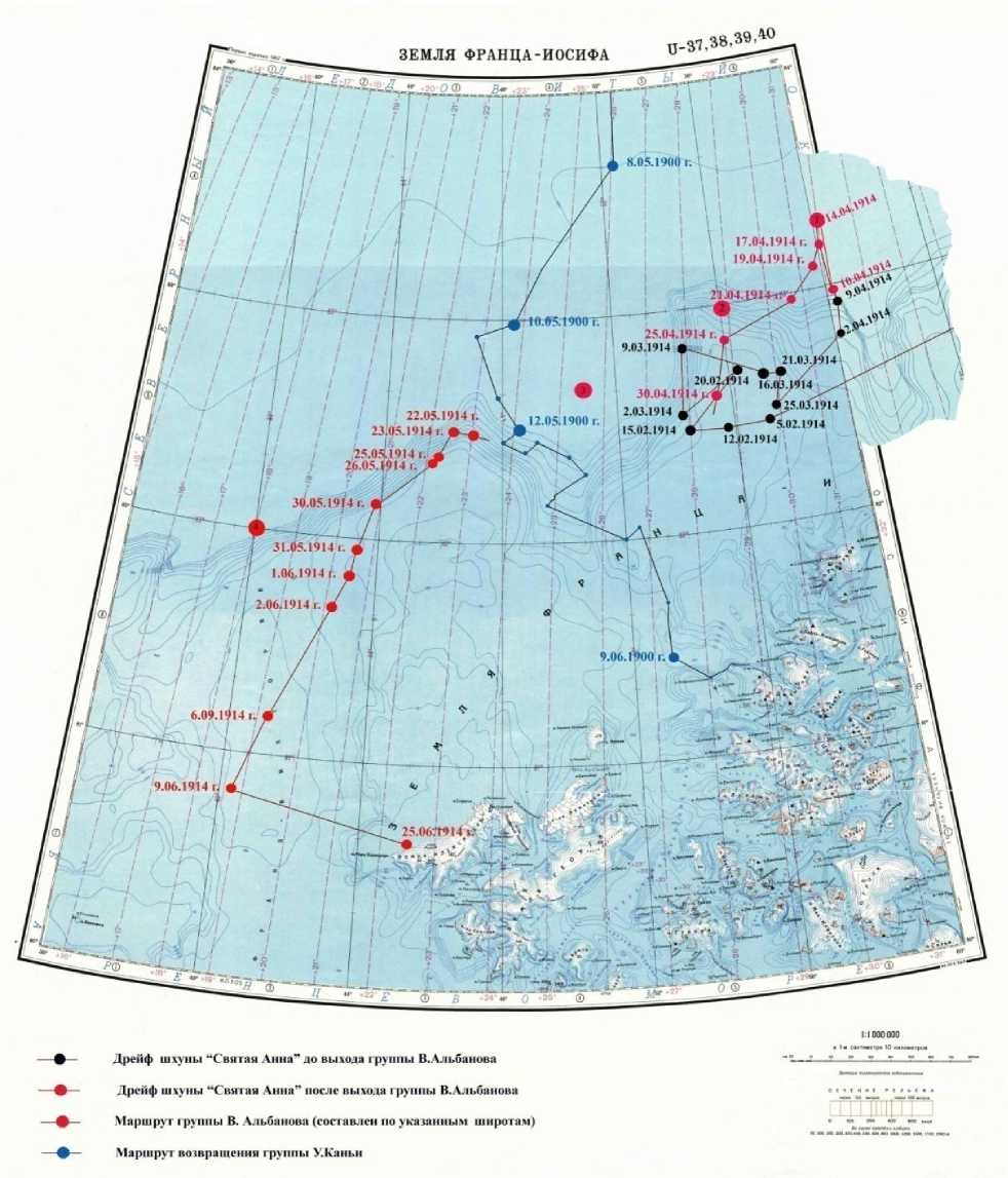
Picture 1. The route of the group of Albanov
Drawn on a map of the route Albanov (picture 1) accurately indicates the direction of ice drift in the SW with the meridian of the island almost to Rudolph and the 40th meridian, where the groove Franz Victoria. Apparently, this channel is a kind of powerful channel of the East Spitsbergen Current, which can be considered the beginning of an underwater promontory (82° 40' north latitude, 47° east longitude). A vessel hit the wing of this movement, drift on W, and especially on the N is in no way it could.
However, only limited information from this source would not be enough, given the initial position schooner above 83 parallels. This sector should be seen as at least one degree higher.
And here it is appropriate to recall a story that miraculously fit in our study - the Italian expedition of the Duke of Abruzzi on the barge "Polar Stella."
Broke through the ice of the Straits of the British PFI, the ship Duke of fall 1899 rose for the winter in the Bay of Teplitz Rudolf Island. The Duke had intended at the end of winter to go to the pole and surpass the achievement of Nansen, but two fingers frostbitten, which had to be amputated, has sent in his sleigh trip mate Umberto Cagni.
Three teams went from the Bay Teplitz in March 11, 1900, Cagni within 45 days reached a point 86 ° 34 'north latitude and 68 ° east longitude. After beating the previous record, the Italians, fearing shortages of food, turned back. A few days later made a determination. Imagine their surprise when it turned out that instead of the proposed alignment between 58 and 60 meridians they are located far west (picture 1). May 12, 1900 Captain wrote: "Longitude 48° 40' Ost. Last night, during insomnia, I once again checked his calculations: there is no error. It is obvious that the ice drift in the south-west direction. Perhaps this is because some days the north wind blows. It bothers me tremendously. If the cause of the drift ice all the wind, then we need to stay calm, but if the drift is due to the passage, we must try much to get back to the 58 meridian, because the two days we drifted to the west for 12 miles. «Realizing that the fight over this is not possible, the Italians took the right decision - to make a quick dash to the south, as soon as possible to get out of alignment, the now famous Trans-currents to the north-east rovam PFI and further along the coast to the base of Teplitz Bay. Eventually, they succeeded.
The materials of the expedition once again confirm the direction of ice drift in the sector 48° - 65° east longitude on the SW, and with an already high 85 parallels. Thus, the available data set allows a high degree of probability to determine the general direction of the drift of "St. Anne" in the sector.
At the end of 1913 the ice floe, in which frozen into "St. Anna", issued for the 82 parallel. Lieutenant Brusilov December 4, identified the 82°14'5'' N, 73°00' east longitude. At this point, an underwater trench, over which the schooner drifted more than a year later to be called by her name, broke off almost vertically in the underwater 2-kilometer propast.Zdes ended Eurasian continental shelf and began a deep part of the Arctic Basin - Basin Nansen. "St. Anna" has entered the zone of the Trans-currents, and the general drift of the course has changed dramatically with N, that the schooner was on the coast of Yamal Peninsula, on W. Offshore wind and a few more months circling "Holy Ann" 60 miles north of the island of Rudolph until the end of March is not attributed back to the ice floe for 60 to 83 parallels the meridian. At this time, half the crew of "St. Anne" was preparing to leave the ship.
At noon on April 10, 1914, before leaving the ship, the navigator Alban took the height of the sun and determined 82°58,5' N and 60°05' S and G. There was a ship flying the north. On this night, the expedition crossed the 83 parallel. George L. ordered to bring a bottle of champagne and a tent of Albanov noted this event. The first Russian expedition reached this latitude. The next day, April 11 storm drove the S even faster ice. Four days later, when the group was Albanov 5 miles from the ship steward John Regald brought a letter from G. Brusilov. It indicated the coordinates of the "St. Anna" - 83°18'.
So, the last thing we know about the "Holy Ann" - is that April 14, 1914 the schooner was at latitude 83° 18' N and 60 minutes from the meridian to the east. On this day, Alban B. wrote: '"St. Anna" was clearly visible. The weather was nice, warm and sunny’. Two days later, the evening of April 16th the schooner was last seen.
From the diaries Albanov and Conrad shows that 14 (point 1, picture 1) on April 25th the wind was N with the short-term course of NNO and SW. Note B. Albanov that "...the summer approaches, and at this time, we must expect more northerly winds, and not the South," was confirmed. The drift of the schooner in such circumstances could only have a south-westerly direction until its output to shelf ledge PFI (point 2). There are two possible versions of events. The schooner could be captured by local currents, as it has been from 5 February to 25 March 1914 and for a time to stay in this square, or drifting SW, gently sloping directly into the mouth of the chute (sector between 48 and 52 and meridians 82 and 83 parallels), which forms during the early, departing to the south (point 3). In the latter case can not ignore the opportunity to enter the schooner into the trough to the British channel. But it would be the shortest way to the Cape Flora, and hence salvation, which, of course, did not happen. Therefore, this version can be viewed only as a general delay in the course due to prolonged chaotic drift in the gutter. Group Albanov almost all unsuccessfully tried to break in May to the south in the sector.
Thus, taking into account the combined effects of flow on the Trans-south-west and predominantly northerly winds of the summer season, of course, the general course of the schooner drift could only be on the SW along the shelf slope. This means that by the autumn of 1914 G. Brusilov expedition could come close to the 82 parallel of the 40th meridian (point 4), in the very place where Franz Victoria trough combines with the Nansen Basin and formed a powerful channel of the East Spitsbergen Current. It would be possible to consider the location of the schooner on that meridian, and at higher latitudes, but so far it had no compelling reason.
And here we come to the point, which was the starting point in the chain of tragic events of the expedition of G. Brusilov. Previous studies have had in this respect are two versions - is the death of the vessel during the compression of ice and fire. The probability of the second version can not be completely accepted and any review, with reference to a fire in the galley, "Fram" in the second drift. The first version, as well as the main, few considered, referring to the opinion of the sailor Conrad, who argued that "the ship was good. We often fall into the severe contraction, but our "Annushka" the egg ice poking out of the shafts. No, it could not crush".
To clarify this question we turn to the list of ships Philomel (Ranger) Class 1859 British Royal Navy, William Loney. February 7, 1861 with the Navy Yard Pembroke Dock in Wales was launched on the water the ship at the time of the newest class of Philomel. Three-masted, with a wooden hull and two-cylinder steam engine of the vessel had a length of 145 feet (44.2 m), width of 25 feet 4 inches (7.7 m) and depth of hold 13 feet (3.96 m). The installed capacity of 325 liters engine. a. (242 kW) gave the speed of 9.25 knots. After installing the guns of the vessel entered the Royal Navy as a gunboat named "Pandora". A year earlier, September 17, 1860 at the same shipyard began construction of six more gunboats in the same class. But December 12, 1863, construction was halted and only four years later, July 20, 1867 one of them is titled "Newport" was launched in April 1868 introduced into the marine research vessels of the ministry.
January 13, 1875, "Pandora", derived from the Royal Navy, sold for "commercial use" Sir Allen Young. Three years later, in early 1878 it was bought by an American newspaper magnate J. Bennett for the Arctic expedition of Lieutenant De Long to the North Pole. In the summer of that year covered the bark and the new name "Jeannette," he went to San Francisco. For navigation in ice block "Jeannette" was reinforced by special plating and more farms from oak (Fig. 2) But these, at first glance, sufficient measures were not able to save the ship from the ice compression. On the night of June 10 the ice around the vessel bred and "Jeannette", referring to the roll of 9 °, straight, afloat, and the next day, the ice fields have begun to converge. De Long later wrote, "June 11, 1881 ... At midnight, all around us there was a terrible crash and roar. Having decided that this time we perish, I rushed on deck. The ship creaked. Spar deck began to climb upward. The ship heeled over at 30 °C and was rapidly sinking into the sea" [6]. "Jeannette" down in the 4:00 am June 12, 1881.
Two months before the tragedy with bark, "Jeannette", in May 1881 is the same Allen Young bought the already mentioned gunboat "Newport." In memory of the last ship he renamed it "Pandora II». Sir Allen knew that at the very time when it was covered by a new name barkentine, the first "Pandora" on the bottom left of the Siberian Sea.
The years passed. "Pandora II», renamed it the next owner of "Blenkatru" has long served their masters, then as the cruise boat, the cargo ship, delivering to the Yenisei materials for the construction of the East Siberian Railway. In 1912, when the barkentine coming to his 45 years of age, it was bought by G. Brusilov for the passage of the Northern Sea Route. Since the former gunboat "Newport" was the legendary "St. Anna".
It would be natural to assume that the court of a class of "Jeannette" and "St. Anna" came down the stocks of one yard, equally unable to resist the ice compression. As the two sisters had lived a long life on the ship's standards, they went to the Arctic to find peace in the cold bottom of the Arctic Ocean. The same was their birth, the same was their last journey. The same opinion is shared by the majority of polar researchers. Nansen wrote that "no one would expect a great strength in her years, and it is obvious that she could not long resist the pressure, before heading to the bottom"2.
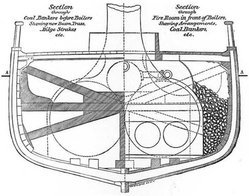
Picture 2. The section of shell bark ''Janetta''
Thus, the most likely cause of the tragic events of the expedition was the death of G. Brusilov ship. But what happened to people? Were you able to save them and save everything you need to go far to land? The answers to these questions can be found in the copy-flight journal "St. Anna": "1/14 of March. Lowered two boats and put on a thick old ice floe at a distance of 150 paces from the ship. On these boats decided to make a reserve stock of provisions in case of accident to the vessel" [4]. In this situation, and in the future, will be apparent that George L. knew firsthand about what happened to the expedition of De Long. The circumstances of the death of "Jeannette" was well known to him, and do not take them into account, he could not. Therefore, doubts that remained on board the "St. Anne", hitting the heavy ice conditions, were able to prepare for the loss of the vessel, not much. Following the example of the American expedition, G. Brusilov is likely to put on the ice two boats with equipment and all the provisions, which were able to unload the doomed ship. Nansen, in his justification of the Transpolar Drift wrote: "A ship is not withstood the compression did not go down so quickly that people did not have time to get over with all the equipment and food to the strong, previously scheduled for the ice floe''3.
There is no doubt about the direction of their path. Even in the order of the transition Al-banov George L. pointed out a well-defined route to the "Svalbard is not moving away out of sight the coast of Franz Josef Land. After reaching Spitsbergen, introduce you to an extremely difficult task to find the people there, the place of stay which we do not know, but hopefully, in the southern part of it - is you can, if not living on the coast, the fishing vessel to catch somewhere"4.
Moving to Spitsbergen G. Brusilov was soon to discover that within, leaving no chance to advance to the SW, take them to the SSO. Once the target of the East Spitsbergen Current, they are exactly the same way the expedition of St. Andre.
It is known that after an unsuccessful attempt to reach the North Pole in a balloon three Swedish aeronautical, headed by C. Andre decided to go to the Cape flora of Franz Josef Land, where they store food was prepared. July 14, 1897 from a point 82°56' north latitude, 29°52' east longitude, they moved to the east. Two weeks later, determining the place of his position - 82 ° 22 'north latitude and 29°12' east longitude, the travelers were somewhat discouraged by the fact that absolutely no progress toward the goal. "We do not deal with any course, no ice - Andre wrote - and we have absolutely no forms to achieve anything if we continue the path to the east. So we agreed to start our new wandering, heading to the Seven Islands ... ‘ By changing course, they immediately hit the target of the East Spitsbergen Current, which is between 81 and 82 parallel begins to deviate to the south and further to the south-east, skirting the North-East Land (Fig. 3). All attempts to overcome it were as vain. September 17 Andre wrote: "But most importantly, we found that for the wind carry us irresistibly into the breach between the North-East Land and Franz Josef Land, we do not have the slightest chance to get to the North-East of the earth." 33 years later they find the remains of the south-western tip of the islands white.
In addition to the overall picture of trends in the area would be appropriate to recall the dramatic events of the Italian Umberto Nobile expedition in 1928. If you carefully consider the drift of "Red Tent" and the route of Andre (Fig. 6), it becomes clear that the local offshore flow to the south of the valley have to Litke western edge of the East Spitsbergen Current one direction SO. In many ways, this contributes to the plateau of Yermak, the counter of the West Spitsbergen Current and the shelf grooves of the Svalbard. And here we can conclude that the ice is located above 82° north latitude on the meridian of the island White, has a greater probability of being in the Greenland Sea between Greenland and Spitsbergen itself, and anything below is not less than the probability of being captured East - Spitsbergen current and drift to the open water in the Barents Sea between Spitsbergen and Franz Josef Land.
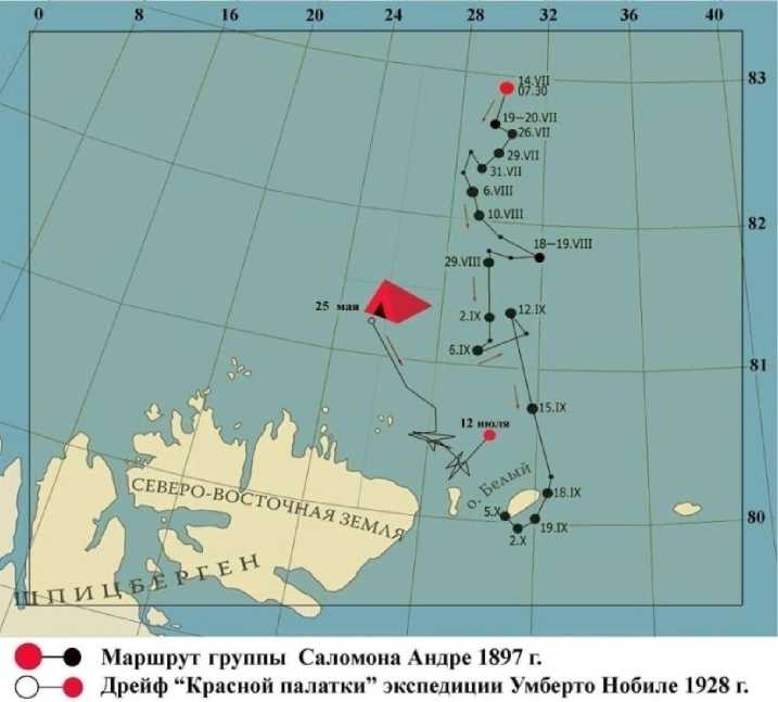
Picture 3. Drift of the ''Red tent'' expedition U. Nobile
All that has happened with the expedition of Brusilov, does not lend itself has any analysis. This is the case when only two equally likely possible versions: the death of Brusilov during a storm in the Barents Sea, or death from starvation in one of the eastern islands of Spitsbergen. I do not want to offer readers the mystical reasons, but very much like Brusilov expedition, and De Long. Landmarks are given. And who knows, may have yet to find the last parking lot missing expedition.
Literaute
-
1. «Osservaziom scientifiche, eseguite durante la spedizione polare di S. A. R. Luigi Amedeo di Savoia». Milan, 1903.
-
2. Diary of a chief of the American expedition to the barge, "Jeannette" Lieutenant D. DeLong, Jeannette Arctic Expedition, 1879-1881, Overview and Selected Images, Naval Historical Center home page.
-
3. Nansen F. in the country of the future: the Great Northern route from Europe to Siberia via the Kara Sea. Magadan, 1969.
-
4. Nansen F. "Fram", "Fram" in the Arctic Sea, Part 1.
Reviewer – Palmin Viktor Andreevich, Ph. D. in History, Associate Professor.
References In the ice of the 40th meridian (the research of the death in the arctic expe-dition of G. L. Brusilov)
- «Osservaziom scientifiche, eseguite durante la spedizione polare di S. A. R. Luigi Amedeo di Savoia». Milan, 1903.
- Diary of a chief of the American expedition to the barge, "Jeannette" Lieutenant D. DeLong, Jeannette Arctic Expedition, 1879−1881, Overview and Selected Images, Naval Historical Center home page.
- Nansen F. in the country of the future: the Great Northern route from Europe to Siberia via the Kara Sea. Magadan, 1969.
- Nansen F. "Fram", "Fram" in the Arctic Sea, Part 1.
