Integrated Traffic Information Service System for Public Travel Based on Smart Phones Applications: A Case in China

Author: Chonghua Zhou, Zhiyong Weng, Chen Xu, Zhizhe Su
Journal: International Journal of Intelligent Systems and Applications(IJISA) @ijisa
Article in issue: 12 vol.5, 2013.
Free access
Owing to its outstanding performance and rich features, Smart phones have been the rapid development over the past decade, more and more people love to use its mobile Application to process the day-to-day affairs instead of PC, including the normal call and Short Messaging Service, Personal Information Management, send and receive e-mail, browse Web, multimedia Applications and online shopping. In April 2011, the Taipei people began to use the free smart phone Apps “Good Travel in Taipei” to check the real-time traffic information of Taipei City Department of Transportation and get the best route plans according to your location, the Apps software brings together road, bus, subway, bike, high-speed rail, airport, parking and other traffic information, can be easily, simple and fast delivery to the public. The papers will introduce the case of “Good Travel in Taipei” firstly, then Zhengzhou is as an example in China to illustrate the Application of integrated traffic information service system for public travel based on smart phones, we hope it can provide a reference for the future construction of the similar mobile App of traffic information service system in the other cities for public travel.
Smart Phones, Mobile Application, Traffic Information Service for Public Travel
Short address: https://sciup.org/15010501
IDR: 15010501
Text of the scientific article Integrated Traffic Information Service System for Public Travel Based on Smart Phones Applications: A Case in China
Published Online November 2013 in MECS
-
I. Background
The smart phone is a general term for the phones, which "like a PC, with an independent operating system, can install software, games, and other third-party programs provided by service providers by the user, through those programs continuously expanding the function of the phone, and accessing network wirelessly through the mobile communication network". Since the launch of the Casio B.O.S.S. in 1989, the smart phone has been the rapid development, and gradually become the future trend of the mobile phone. It is predicted [1] that to 2013, the number of the internet users using mobile will reach 1.78 billion worldwide, more than the number of the users using PC. Simultaneously there will be total 1.82 billion devices Including smart phones and other internet phone. Accompanied with the rapid development of smart phones, the mobile Applications showing a soaring development trend, instead of the PC to handle part of the daily affairs, including personal information management, calendar notes, scheduling task, multimedia Applications, browsing the web to send and receive e-mail, online shopping and so on. According to the report of the market research firm Juniper Research [2]: in 2015, the numbers of the smart phone software downloads will reach 25 billion. It is foreseeable that the mobile Applications will pervade every aspect of our lives and indispensable to people's lives. The traffic information is published to the general public free through smart phone’s App. This papers based on the analysis of "Taipei good line" system, aimed at the current situation and actual demand of the
Zhengzhou traffic information, proposed the system architecture of Zhengzhou traffic information service for public travel based on smart phones Apps, and deepening design its function.
-
II. “Good Travel in Taipei” Case Review [3]
-
2.1 Travel in Flora Expo
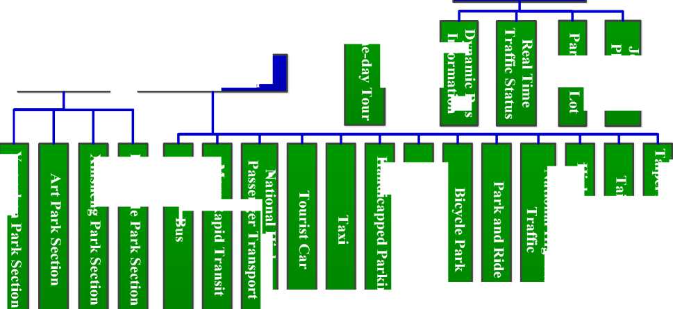
2010 International Flora Exposition was hold in Taipei 2010, referred to the Taipei Flower Expo. To query traffic information and browse the propaganda website of Taipei Flower Expo for people, Taipei City Department of Transportation and Jing Yi Technology Company developed an Apps “Travel in Flora Expo” in IOS and Android for people to free download in 2010. From Travel in Flora Expo launched in early October 2010 to the end of 2010, Travel in Flora Expo had be download 40000 times in IOS and 9000 times in
Android. Travel in Flora Expo’s functional architecture is shown in Fig.1.
To meet the growth demand of the traffic information and smart phones with different operating system, and With Taipei Flower Expo end operations on April 25, 2011, The Taipei government expand the App (Realtime Traffic Information Smartphone Application Program) in three aspects: @ launched App "Good Travel in Taipei" combined of LBS (Location Based Service) function; @ provide personalized traffic information service: "Good Travel in Taipei" mainly have two personalized traffic information service, one is " Remind of bus arrival", the other is "Real-time traffic condition of the route frequently used"; ® more choice of smart phones operating platform, such as IOS, Android, Windows phone.
Travel in Flora Expo
Exhibition information Traffic Information Sightseeing trips
Latest News
About Flora Expo
Flora Expo Traffic Information
Taipei
Traffic Information
Section
Means of Transportation
sc
2 в"
В" ГС 5
JO
= 2 в 6
в
CTO
в
CTO
2 в в в
в
5* гсе
S в,
5 в
Щ тс
В" 3 в
S в,
5 S3
Fig. 1: Travel in Flora Expo’s Functional Architecture
о в
в «с У» у
» ч В. в в л
к в в в
В в в
5?
a
S ^
Я
CTO
Щ в в а
2 в" л
S тс’
В" 5 в
S тс’ В"
я тс в*
■в л л а
3 в в
О о 5 гс
>
•3
-
2.2 "Good Travel in Taipei"
-
2.2.1 System Architecture
-
"Good Travel in Taipei" App combining the LBS positioning technology and the dynamic path planning based on GPS (Global Positioning System), covering different transport information, provides a convenient Taipei traffic information query method, making users a smart phone in hand, a good travel in Taipei. "Good Travel in Taipei" App’s system architecture features shown in Fig.2:
Major Function
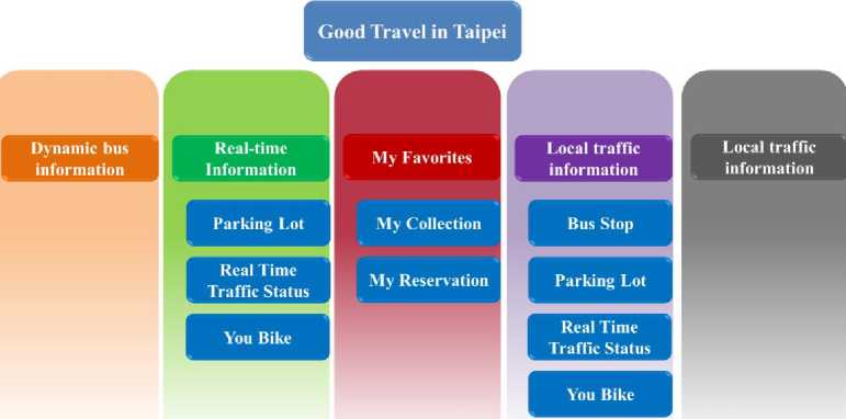
Fig. 2: Good Travel in Taipei’s Functional Architecture
.uiiT¥®8 за 15:18
Main Interface
Ш^^ЯЙТ^ЖШ ИВ»ШЙ:53 TEL:2357-8564 ШЛЭ(2Ф8) №Й$<ЙЙ:53 TEL:2357-8564 вейвтая
MB me® 53 TEL:2357-8564
#S£0itiTf9««
MB me® 53 TEL2357-8564
Ж;ШФ1ЁТ»Ж«
Mtt»ti®:53 TEL:2357-8564
дйнфйтжж*
J4B*tt®:53 TEL:2357-8564
ЙНЙВ
ЕЮ
'_JL^^^
Ltt*L4eaiteUefi*
*.7.8.9.
Bus Dynamic Information
а '_.1||ф1йМ8 за 15:18
Real-time Parking Information
-шф#5'й за 12:18
№$ii
8Ф£
4*»5 ^®
r#s£-mssi" 236
6^^^:^^.^Ж
вмхейа
14а
16а
1 я
4я
6я
7 Я
2а
Оя
ШЖ^ЛКК^
Й№М
—*ф
rS^ABf/J' ® мфкй*...® №ЖФ1ЕеФ...® ffiffiffin ® аитнйпйс® у, 8Ж®Ж№8|П®
. 51-^18. Ф@1Й1Й. №
Bus Dynamic Information
a ^dirpMSil за 19:26
#^жЖ йв °1^»а д@ЙК
Й^ЙЖ ЕГ.ЙЙЙ ИИЙИ 8№ НК
а ^
»®й* епййй №ЙЙЯ swag ик
Real-time Road traffic Information
G» ^1ФЖ5В 30 19:26
^Ф®
^^1Ф
2328(1
232И
2328У
508'
508 @
2251(
2254#
M
M ig$
iS^
s@ £*1_ igfi 5^ >8 M
M
а & а ^ ез в®й» юйяя ййяа аме® вк
Real-time Bike Information Approaching Bus Information Approaching Bus Information
-Г 35 jllCpWSBlg 30 12:18
GD .Miiu ^ifif, за 15:18 =
|
I»J BfttsRf! |
||
|
* |
дцтякятее |
|
-.тФЖЩЙ, за
iwawssei
4.$Й8№9М:
1 ия»йжй№
|
286 |
23 |
|
*« ■ яягоа: |
|
|
Гйй$ййп |
|
|
ФЮ 0-15 |у ^ЯНИ |
|
|
АМ7:06-АМ8:00 |
- |
Approaching Parking Information Approaching Parking Information
My Love (Bus Stop)
Fig. 3: Good Travel in Taipei’s UI of Functional Modules
4.ая№«19$
^шзё
1 ЯЯ11ЯЙ1
My Love (Road Travel)
-
2.2.2 Instruction of Functional modules
Good travel in Taipei’s main interface have followed modules: @ Bus Dynamic Information Query: Input the query bus, the App will display the bus’s route and predicted arrival time between stations. @ Real-time traffic query: Provided people with the real-time parking information (the amount of remaining parking spaces), real-time traffic information and “smiling cycling” information in Taipei. @ Surrounding transportation resources query: Provide location-based services, show the users current location on the map and offer the information about the bus’s predicted arrival time, the parking, the traffic condition and the “smiling cycling” surrounding. @ Custom: Collect specific bus routes, “smiling cycling” rental, parking, and so on in the above query. In addition, two customization service, " the remind of bus arrival times " and "the real-time traffic condition of common routes", are provided in “Reservation”.Above all shows in Fig.3 Good Travel in Taipei’s UI(user interface) of functional modules.
-
III. Analysis of Zhengzhou Public Travel Information Service Demand
Zhengzhou is the capital and largest city of Henan province in north -central China. A prefecture-level city, it also serves as the political, economic, technological, and educational centre of the province, as well as a major transportation hub for Central China. The city lies on the southern bank of the Yellow River, and is one of the Eight Great Ancient Capitals of China. With 8,626,505 inhabitants according to the 2010 census and 3,980,250 in its built-up area (6 urban districts + 5 City + 1 County), the city is one of the main built up areas of Henan region. Zhengzhou is now a rapidly growing city, one of China's eight ancient capitals, Chinese Excellent Tourism city, and in this papers Zhengzhou is as an example in China to illustrate the Application of integrated traffic information service system for public travel based on smart phones.
-
3.1 Large Number of Smart Phone Users in
-
3.2 Zhengzhou Traffic Information Construction Status
The achievement of the construction of Zhengzhou city traffic information is significant. In public transport aspects: The Public Transport Corporation established and succession to improve the wisdom scheduling system, targeting on the bus’s scheduling, management and monitoring, based on GPS from 2009. Also the transit information such as vehicles arrive time can be published though website, WAP mobile phone and station electronic screen. In summary, the information provision in the transit has a good foundation.
3.3 Zhengzhou Traffic Information Construction Status
Zhengzhou
In the ITS, the Zhengzhou city government invested Y 89.16 million Yuan in first-stage construction of urban intelligent traffic management system. The system includes six subsystems: Traffic signal control systems, traffic information collection system, traffic guidance systems, intelligent vehicle monitoring and recording (bayonet) system, traffic video surveillance systems, and traffic violation monitoring system. And second-stage of the project will total investment 90.8 million Yuan and add about 1200 detectors in 30 road 400 sections. ITMS (Intelligent traffic management system) will be divided into two parts, after the completion project it can satisfy the actual needs of the city road traffic management, at the same time solve the actual problems of the traffic management. The first batch of construction include auxiliary decision-making of traffic management and the simulation system, traffic information and public service platform, traffic information collection system (Continue to construction), traffic video monitoring system
(Continue to construction), the traffic guidance system (Continue to construction), intelligent traffic integrated management platform (Continue to construction), with bidding in the middle of September, started construction in early October, and completion in late November, in 2011. The second batch of construction include vehicle intelligent monitoring and recording system, traffic signal control system, mobile police and PGIS (police geographic information system), the GPS positioning system, and transformation of the command center , etc. The construction plan bidding in Early October, begin construction late October, complete in December late. Zhengzhou city has set up and improve the traffic monitoring and information display system, in the future the platform will also link traffic of urban intelligent traffic management system, presenting the real-time traffic information on the platform. To sum up, Zhengzhou has provided well infrastructure in intelligent transportation, and is beneficial to construction of information integrated platform in the future.
From the end of April 2011, Taipei City Department of Transportation begin to provide "Good Travel in
Taipei " App in the App Store and Android Market. The APP involving Taipei dynamic traffic information (parking, real-time traffic, cycling ...), bus and subway interchange recommended, bus information and other information. At the end of June, the APP has been downloaded more than 80,000 times, once ranking NO.1 among the travel category in the App Store, which shows the urgent needs of the people to the realtime traffic information.
The Zhengzhou citizen is no exception, having strong demand for the static traffic facilities information and real-time traffic information before the trip and travel. However, the available way to deliver transportation information is very limited, mainly though the guidance screen (traffic guidance and Parking Guidance) and supplemented website, radio. Urban road traffic, bus, taxi, subway, airport and bus real-time information that citizens are unable to get, even the static transport facilities information are not be provided enough. In view of the urgent needs of the people over traffic information, making full use of and mining the Zhengzhou city’s existing traffic information resources through the smart phone to widely distribute traffic information, enables people to keep abreast of the realtime traffic conditions of variety transport modes in the City, helping in planning travel routes, saving travel time and choosing transport mode, then improving the city’s traffic operating efficiency.
-
IV. System Planning and Design
-
4.1 The Center of Traffic Information Integrated
-
Now the Zhengzhou citizens who want to get traffic information have to respectively browse the websites of the various units. At the same time, in the websites the information such as subway, high-speed rail, Airlines and others which people will often use, need to expanded and integrated. And the information of Lane reduction or diversion caused by road construction also should be provided later. All in all, the integrated traffic information center can sum and post all available information, making the Zhengzhou public or even foreign people to obtain relevant information via the traffic information center as show in Fig.4.
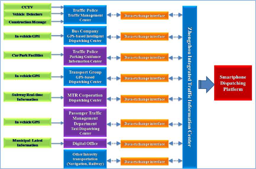
Fig. 4: The Future vision of Zhengzhou City Traffic Information Platform
For current Zhengzhou traffic information, this paper gives the plan and schedule of the traffic information aggregation and release as shown in the Table 1. Described as follows: The GPS dispatch center of public transportation system basically completed can publish information; Traffic management system first-stage is finished and available to provide real-time traffic information about the artery; The long-distance passenger transportation aspect now only provide static information such as hub station, bus terminal, routes and bus schedule; Parking part now can only provide static information such as parking location and parking numbers and so on; As the small demand for taxi information at this stage so it were not provided; Subway Information will be provided in the completion of the subway: Other intercity transportation is more simple, planning to provide in link Mode.
Table 1: The Plan and Schedule of the Traffic Information Aggregation and Release
|
Project Item |
Information |
Source |
Information Provision Currently |
|
Bus |
Station Locations, Realtime Dynamic Information |
Bus Company |
Bus Static and Dynamic Information |
|
Road |
Velocity, Degree of Traffic Jam, Video, Construction Message |
Traffic Police |
Part of Road Traffic Information |
|
Long-distance Passenger Transport |
Passenger Terminal Locations, Route, Number of Runs, Real-time Dynamic Information |
Transport Group |
Passenger Terminal Locations, Route, Number of Runs, |
|
Parking Lot |
Locations, Real-time Vacant Position Number |
Parking Management Center |
Locations |
|
Taxi |
Real-time Dial-a-cab Service |
City Management Office |
Unavailable |
|
Subway |
Station Locations, Bus Route |
MTR Corporation, Bus Company |
Unavailable |
|
Intercity Transport |
Railway, Highway and Air Information |
LINK to Webpage |
Provide Information by LINK |
Table 2: The Smooth Traffic in Zhengzhou Function Structure
|
Project Item |
Data Category |
Data |
Function |
|
Bus Information |
Static |
Route Inquiry |
Input link number, display stations on simplified maps. |
|
Station Inquiry |
Enquire stations near fix location within certain range. |
||
|
Transfer Inquiry |
Input start and end position coordinates and plan feasible bus traveling track or feasible bus transfer track. |
||
|
Dynamic |
Arrival Distance |
Input link number and stations and inform user of nearest distant to stations respectively. |
|
|
Latest News |
Bus transportation companies provide most recent station information, including bus line changes. |
||
|
Road Information |
Dynamic |
Average Speed |
Input selected road and display traffic states between links in different colors (red, yellow and blue; red means congestion). |
|
Construction Message |
Display recent construction information in table format. |
||
|
Traffic videos |
Input selected roads, display real-time video information (This function is unavailable due to traffic management facility update). |
||
|
Latest News |
Traffic police provides most recent traffic information, such as traffic incidents. |
||
|
Intercity Transport |
Static |
Route Inquiry |
Input selected links, display stations covered by enquired line. |
|
Site Inquiry |
Input selected stations, display lines between stations. |
||
|
Bus Lines Inquiry |
Input selected stations, display reachable traffic lines near input stations. |
||
|
Dynamic |
Latest News |
Transportation Group provides most recent bus information, such as lines adjustment. |
|
|
Parking Lot Information |
Static |
Parking Lot Inquiry |
Enquire surrounding parking areas based on fixed location, and show Number of remaining seats available. |
|
Parking Lot Nearby Inquiry |
Enquire surrounding parking areas based on fixed location, and display them on GIS map, enquiring range can be set. |
||
|
Airport & Railway |
Dynamic |
Railway Real-time Dynamic Information |
Links to Zhengzhou Railway Web sites. |
|
High-speed Railway Real-time Information |
Links to Zhengzhou High-speed Railway Web sites. |
||
|
Airport Real-time Information |
Links to Zhengzhou Airport Web sites. |
-
4.2 Content and Function
-
4.3 System Architecture
-
4.3.1 System Architecture
-
-
4.3.2 The Traffic Information App
-
4.4 Integrated Platform
References Integrated Traffic Information Service System for Public Travel Based on Smart Phones Applications: A Case in China
- Communication Information News. (2010). “iPhone flip the smartphone craze and the three major trends development showed of smart phone.” http://news.yesky.com/416/11394916.shtml (Sep. 8, 2012).
- DEVX Staff. (2010). “25 Billion Mobile App Downloads by 2015.”, http://www.devx.com/DailyNews/Article/45185?trk=DXRSS_LATEST (April 10, 2012).
- ZHOU Chong-hua, GAO Zuo-gang, XU Chen and SU Zhi-zhe. (2012) “Research on Traffic Information Service System for Public Travel Based on Smart Phones Application” [J]. Traffic & Transportation, 2012(z1), p77~79. (in Chinese).
- Zhengzhou Bureau of Statistics, Henan survey organization national bureau of statistics information network. (2012). “2011 Zhengzhou City, the national economy and social development statistical bulletin”. http://www.ha.stats.gov.cn/hntj/tjfw/tjgb/sxsgb/webinfo/2012/03/1332823947537928.htm (Nov.30,2012).
