Livestock pressure and ecohydrological stability of the Orkhon river basin, Mongolia

Автор: Bat-Erdene Mytav, Weibo Ren, Adiyadulam Mygmarsuren, Erdenebayar Bavuu, Bilguun Tsogoo, Batsuren Dorjsuren
Журнал: Природа Внутренней Азии @nature-inner-asia
Рубрика: География
Статья в выпуске: 2 (35), 2026 года.
Бесплатный доступ
The Orkhon River basin is a major socio-ecological region of Mongolia where rangeland use, climate variability, and watershed processes are tightly coupled. This article investigates how growing livestock pressure reshaped ecohydrological stability in the basin during 1990–2025. The analysis is based on a focused synthesis of the author’s doctoral dataset, including official livestock statistics, landsat-derived land-cover and vegetation information, hydrometeorological observations, GIS-based spatial comparison of pasture use and environmentally sensitive sectors. The evidence indicates that total livestock numbers increased by about 2.2 times after 1990 and that herd composition shifted toward a larger share of goats. Grassland remained the dominant land-cover type, yet it became more variable through time, especially during dry periods and in areas exposed to concentrated grazing. Bare land expanded during major degradation intervals, while wetland and water-related surfaces contracted overall. The middle and southern parts of the basin show the strongest coincidence of intensified grazing, vegetation drought, and reduced ecohydrological buffering capacity. In practical terms, these changes lower infiltration potential, weaken soil-moisture retention, and make runoff generation more seasonally unstable. The article demonstrates that ecohydrological vulnerability in the Orkhon River basin can not be attributed to climate forcing alone; it is reinforced by herd growth, herd-structure change, and uneven spatial concentration of grazing pressure. The results support climate-adaptive pasture management, carrying-capacity regulation, and basin-scale restoration planning.
The Orkhon River basin, livestock pressure, grazing, ecohydrology, grassland degradation, Mongolia, water resources
Короткий адрес: https://sciup.org/148333566
IDR: 148333566 | УДК: (556)517.3 | DOI: 10.18101/2542-0623-2026-2-63-77
Влияние пастбищной нагрузки на экогидрологическую устойчивость бассейна реки Орхон, Монголия
Бассейн реки Орхон является одним из важнейших социально-экологических регионов Монголии, где пастбищное животноводство, климатическая изменчивость и воднобассейновые процессы взаимодействуют в условиях уязвимых сухостепных ландшафтов. В статье анализируется влияние роста пастбищной нагрузки на экогидрологическую устойчивость бассейна в 1990–2025 гг. Исследование основано на оригинальных материалах докторской работы Бат-Эрдэнэ и включает официальную статистику поголовья, дистанционные данные о земном покрове и растительности, гидрометеорологические наблюдения и пространственный анализ в ГИС. Показано, что общее поголовье увеличилось примерно в 2,2 раза, а доля коз заметно возросла. При этом пастбищные травянистые сообщества оставались доминирующим типом покрова, но испытывали сильные колебания, особенно в засушливые периоды и в районах с высокой концентрацией выпаса. Расширение площадей оголенных земель и сокращение водно-болотных и водных поверхностей указывают на ослабление инфильтрационной и влагоудерживающей функций ландшафта. Наиболее уязвимыми являются центральные и южные части бассейна, где усилившаяся нагрузка совпадает с более выраженной вегетационной засухой. Сделан вывод, что экогидрологическая уязвимость бассейна р. Орхон определяется не только климатом, но и ростом стада, изменением его структуры и пространственной концентрацией выпаса. Полученные результаты подчеркивают необходимость управления пастбищной емкостью, адаптивного регулирования выпаса и восстановительных мер на уровне всего бассейна.
Текст научной статьи Livestock pressure and ecohydrological stability of the Orkhon river basin, Mongolia
Inner Asian river basins are shaped by the combined action of climate, water, vegetation, land use, and mobile pastoralism. In Mongolia this interaction is especially pronounced because extensive livestock grazing remains the dominant land-use system across large semi-arid and dry-subhumid landscapes. Under such conditions, ecohydrological stability depends not only on the amount of precipitation received, but also on the capacity of vegetation and soils to regulate infiltration, evapotranspiration, and runoff formation.
The Orkhon River basin is one of the key natural and socio-economic regions of Mongolia and an important component of the Selenge-Baikal drainage system. Roughly one quarter of the national population and a substantial share of industrial activity are concentrated within the basin, while its grasslands support extensive livestock production. Because the basin lies in the arid and semi-arid transition belt of Central Asia, relatively modest shifts in climate or land use may trigger disproportionately large hydrological and ecological responses.
Previous studies in the basin have documented warming, increasingly uneven precipitation distribution, seasonal runoff reorganization, land-cover change, and rising pressure from mining, agriculture, urbanization, and grazing. Yet livestock pressure has mostly been treated as one background variable within broader climate-hydrology assessments. A dedicated interpretation is needed because herd growth, especially growth in goats, can alter aboveground biomass, root systems, soil compaction, infiltration conditions, and the resilience of pasture ecosystems during drought.
The purpose of this article is to evaluate how livestock pressure affected ecohydrological stability in the Orkhon River basin during 1990-2025. Its novelty lies in extracting the grazing-pressure dimension from the broader doctoral dataset and interpreting it as an ecohydrological driver rather than merely as a contextual land-use indicator. The article therefore: (1) summarizes long-term livestock dynamics; (2) interprets associated changes in grassland and degradation-sensitive land-cover classes; (3) assesses the spatial coincidence between grazing intensity and ecohydrological vulnerability; and (4) discusses implications for integrated basin management.
Material and methods1.1 Study area
The Orkhon River basin occupies approximately 53,784 km2 in central Mongolia and extends from the forested and mountainous headwaters of the Khangai region to steppe valleys and lower alluvial sectors connected to the Selenge system (Fig. 1). Elevation ranges from about 3,539.9 m in the upper catchment to around 601.1 m near the basin outlet. The basin includes mountain-steppe, forest-steppe, meadow, river-valley, and lake-margin environments, creating a strong natural gradient in water availability, vegetation productivity, and pasture use.
This geographical setting is important for ecohydrological interpretation because the basin combines relatively humid upper reaches with more climatically stressed middle and southern sectors. The study area therefore offers a good regional example of how climate variability and livestock pressure can jointly influence land cover, vegetation condition, and the hydrological buffering capacity of dryland landscapes.
1.2 Data sources and analytical approach
The article draws on the author’s integrated doctoral dataset for 1990–2025, which combines four main data groups: (a) official livestock statistics for the basin and its administrative units; (b) remote-sensing products derived from Landsat imagery; (c) hydrometeorological observations from representative stations within the basin; and (d) GIS layers describing basin boundaries, rivers, lakes, soum boundaries, and landcover structure. For land-cover analysis, multi-temporal Landsat TM, ETM+, and OLI images from 1990, 1995, 2000, 2005, 2010, 2015, 2020, and 2025 were used. All images underwent standard pre-processing, including geometric correction, atmospheric correction, cloud masking, and projection to a common coordinate system, in order to ensure interannual spatial consistency and comparability. The land-cover mapping was conducted at 30 m spatial resolution. Land cover was classified into eight categories: grassland, shrubland, bare land, forest, water, cultivated land, artificial surfaces, and wetlands. A supervised classification approach was applied. Training and control samples were selected using topographic maps, high-resolution imagery, and field-investigation materials, which helped reduce confusion among ecologically similar dryland classes.
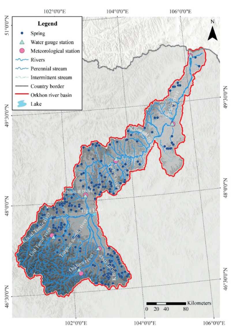
Fig. 1. Location of the Orkhon River basin, river network, springs, and representative monitoring stations used in the doctoral dataset
Classification reliability was checked using training and control samples and crosscompared with topographic maps, high-resolution imagery, and field-investigation materials to ensure interpretive consistency at basin scale. Because the present article is a focused synthesis derived from the broader doctoral dataset, the land-cover classification is used here primarily for basin-scale comparative interpretation rather than for a stand-alone accuracy-driven remote-sensing assessment. The classified outputs were interpreted together with NDVI, VCI, livestock-distribution patterns, and hydrometeorological context in order to identify sectors where grazing pressure and ecohydrological vulnerability spatially coincided. For the grazing-pressure component, both total herd size and herd composition were evaluated using official statistical material for 1990–2024/2025 (Table 1).
Table 1
Datasets and variables used in the ecohydrological interpretation of livestock pressure in the Orkhon River basin
|
Dataset / variable |
Period or source |
Ecohydrological interpretation |
|
Livestock numbers and herd structure |
1990–2025 official statistics |
Used to track growth of stocking pressure and the increasing share of goats |
|
Landsat-based land cover |
1990–2025 basin classifications |
Used to interpret changes in grassland extent, bare land expansion, and moisture-related classes. |
|
NDVI and VCI products |
Multi-temporal remotesensing analysis |
Used to assess vegetation condition, drought stress, and ecohydrological vulnerability |
|
Hydrometeorological context |
Station observations within the basin |
Used to situate grazing impacts within a warming, precipitation-variable, and hydrologically sensitive environment |
|
GIS basin layers |
River network, lakes, basin and soum boundaries |
Used for spatial comparison of grassland distribution, livestock concentration, and vulnerable sectors |
In the basin-scale interpretation, livestock pressure is treated not simply as animal abundance, but as the combined outcome of herd growth, rising goat share, and the localized concentration of stocking intensity. This approach does not replace a standalone grazing index or process model; rather, it allows a conservative synthesis of multiple lines of evidence derived from the same research program (Fig. 2).
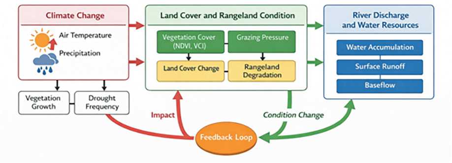
Fig. 2. Conceptual framework used to interpret links among climate forcing, rangeland condition, grazing pressure, and river-basin water resources
Results2.1 Livestock dynamics and herd structure
The basin dataset reveals a pronounced increase in livestock numbers after 1990. Total livestock grew by about 2.2 times over the study period, and herd composition shifted toward a larger share of goats. In 1990 the goat share was about 11 %, but by 2024 it had increased to about 27 % (Fig. 3). This result is ecohydrologically significant because goats impose stronger browsing pressure, contribute to selective biomass removal, and tend to intensify degradation on already stressed pasture surfaces.
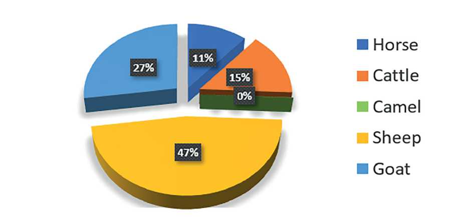
Fig. 3. Livestock herd structure used for interpreting the relative pressure of different animal groups in the basin dataset
The rise in herd numbers should not be interpreted as a simple socioeconomic indicator alone. In a dryland basin, herd growth changes the physical interaction between vegetation and soils: repeated defoliation lowers aboveground cover, trampling alters surface structure, and concentrated use near water points, settlements, and accessible valley bottoms increases patch-scale degradation. These effects are stronger when herd composition becomes increasingly dominated by species that browse more selectively or utilize fragile shrub and forb communities. Thus, livestock pressure modifies both biological productivity and hydrological functioning of pasture landscapes.
2.2 Land-cover shifts associated with pasture pressure
Land-cover analysis supports the livestock-pressure interpretation. Grassland remained the dominant class throughout 1990–2025, but its area varied markedly through time. In 1990, grassland covered 29,194.9 km2; by 2000 it had declined to 25,741.3 km2; it decreased further to 24,645.1 km2 in 2015, before partially recovering to 28,239.6 km2 in 2025. Bare land expanded strongly during the main degradation phase, rising from 12,350.5 km2 in 1990 to 16,110.4 km2 in 2000 and peaking at 16,995.6 km2 in 2015 before decreasing to 12,839.9 km2 in 2025 (Table 2). Water surfaces and wetlands also show an overall contraction across the study period.
Selected land-cover indicators extracted from the author’s dissertation and used in the present synthesis
Table 2
|
Indicator |
1990 |
2000 |
2015 |
2025 |
|
Grassland area (km²) |
29,194.9 |
25,741.3 |
24,645.1 |
28,239.6 |
|
Bare land area (km²) |
12,350.5 |
16,110.4 |
16,995.6 |
12,839.9 |
|
Interpretation |
Baseline pasture dominance |
Strong degradation phase |
Peak degradation-sensitive extent and minimum grassland extent |
Partial recovery, but not full restoration |
These shifts suggest repeated ecohydrological stress and degradation-sensitive transitions rather than stable recovery (Fig. 4). The observed increase in grassland area by 2025 does not necessarily mean complete restoration of pasture function; in dryland systems, nominal areal recovery can coexist with reduced biomass, lower root density, patchier cover, and weaker control over infiltration and soil-water retention. For this reason, land-cover stability should not be equated automatically with ecohydrological resilience.
2.3 Spatial concentration of livestock pressure
The relationship between climate and vegetation observed in the companion landcover analysis indicates that precipitation alone cannot explain grassland behaviour. Additional pressures – especially grazing concentration and warming — are needed to account for the observed spatial and temporal shifts in vegetation cover. Within an ecohydrological framework, livestock pressure functions as a stress amplifier: it weakens the drought resistance of grasslands and lengthens recovery time after dry years.
Spatial maps extracted from the doctoral dissertation reinforce this conclusion. Grassland remains widely distributed across the basin, but livestock density became much more concentrated and extensive in the later period. The strongest pressure zones align with the middle and southern sectors of the basin, where the combination of drier conditions, intensive land use, and repeated vegetation stress creates the highest vulnerability (Fig. 5). These are also the zones where the dissertation identified stronger vegetation drought intensity and broader impact areas.
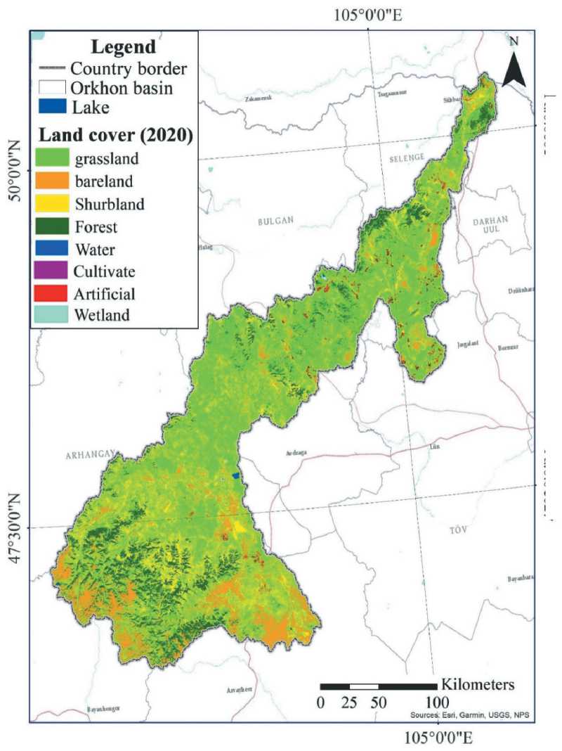
Fig. 4. Example of land-cover structure in the Orkhon River basin (2020), showing the dominance of grassland and the distribution of degradation-sensitive classes
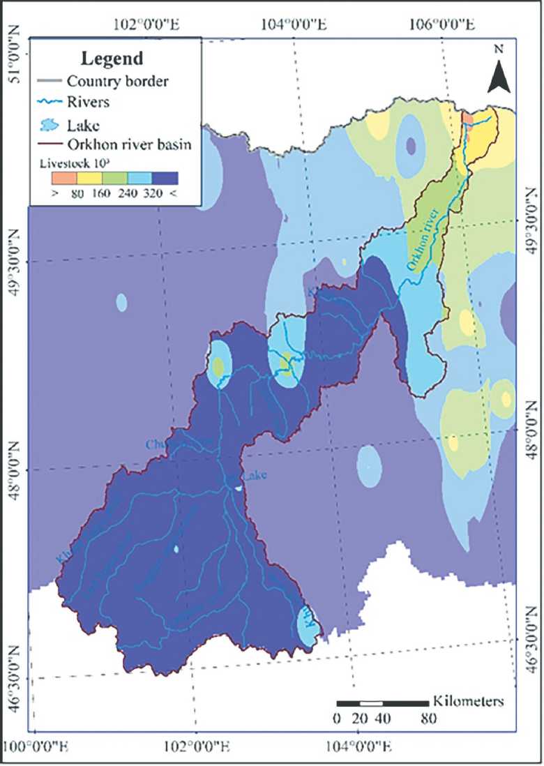
Fig. 5. Example of the spatial distribution of livestock concentration in the Orkhon River basin, illustrating pressure hotspots in the middle and southern sectors
2.4 Ecohydrological implications
From an ecohydrological standpoint, the documented land-cover shifts have direct functional consequences. When persistent grazing reduces vegetation cover and litter input, the protective role of the grassland canopy declines. Soil surfaces become more exposed to raindrop impact, trampling, and summer desiccation, which lowers infiltration capacity, weakens soil-moisture retention, and reduces the generation of more stable subsurface and baseflow contributions.
At basin scale, these changes increase the sensitivity of runoff generation to shortterm rainfall variability. In practical terms, a catchment with weakened vegetation cover and disturbed soils tends to produce less buffered and less predictable water responses: peak flows may become flashier in some sectors, while low-flow resilience can weaken as the storage function of soils and near-surface layers declines (Fig. 6). The broader doctoral interpretation further suggests that intensified grazing and surface degradation can hinder the transfer of precipitation toward deeper soil water and groundwater storage compartments, thereby weakening baseflow maintenance during dry periods.
Discussion
The central contribution of this article is to show that livestock pressure should be treated as a principal ecohydrological driver in the Orkhon River basin, not as a secondary background factor. Climate change remains the dominant regional forcing, but basin response is mediated by vegetation cover, soil condition, and the spatial concentration of human use. In this context, herd growth and the increasing share of goats are especially important because they intensify browsing pressure, reduce vegetation recovery potential, and increase the likelihood that climatically dry years translate into more persistent landsurface degradation.
The combined evidence from land-cover classification, NDVI/VCI interpretation, and livestock statistics suggests that the middle and southern parts of the basin represent the most vulnerable ecohydrological sectors. These areas are characterized by stronger vegetation drought, greater concentration of grazing pressure, and repeated transitions toward degradation-sensitive land-cover states. This spatial coincidence supports the interpretation that precipitation variability alone cannot explain observed grassland instability; rather, climatic stress is magnified where pasture use is concentrated and ecosystem recovery is weaker.
A key implication is that pasture degradation should also be viewed as a waterresources problem. When repeated grazing pressure lowers vegetation cover and litter input, soil surfaces become more exposed to trampling, crusting, and summer desiccation. Under such conditions, infiltration potential and soil-moisture retention decline, while runoff becomes more sensitive to short-term rainfall variability. The doctoral framework additionally suggests that this process may reduce transfer of water toward deeper soil and groundwater storage, thereby weakening baseflow maintenance during drought periods.
These findings are consistent with broader ecohydrological theory and with Mongolian and other dryland basin studies showing that climate anomalies produce stronger hydrological instability where vegetation and soils are already degraded.
46°30'0"N 48°0'0"N 49°30'0"N 51WN
46°30'0"N 48°0'0"N 49°30'0"N
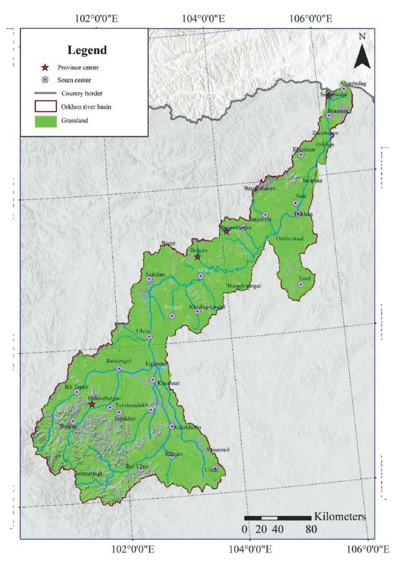
Fig. 6. Basin-wide distribution of grassland, showing the spatial framework within which grazing pressure affects ecohydrological stability
For the Orkhon River basin, the management implication is straightforward: climate adaptation cannot rely only on monitoring temperature and precipitation or on conventional hydraulic responses. It also requires explicit grazing-pressure management, carrying-capacity regulation, spatially differentiated pasture governance, and restoration of hydrologically sensitive valley-bottom and drought-prone grassland sectors.
The article also has limitations. It is based on a focused synthesis of the author’s original doctoral dataset rather than on a new stand-alone statistical model calibrated only to grazing intensity. Consequently, the interpretation should be read as strong convergent evidence rather than as a formal causal model. A logical next step would be to construct a quantitative grazing-pressure index and test it against runoff sensitivity, soil-moisture proxies, and vegetation-recovery rates at sub-basin scale.
Conclusion
The Orkhon River basin illustrates a characteristic Inner Asian dryland problem: a climate-sensitive water system that is increasingly stressed by expanding livestock pressure. The evidence synthesized from the doctoral dataset shows that total livestock numbers increased by about 2.2 times after 1990, the share of goats rose substantially, and these trends coincided with repeated degradation-sensitive land-cover transitions, especially in the middle and southern sectors of the basin.
Grassland remained the dominant land-cover type, but its ecological function became less stable, reaching a reduced extent of 24,645.1 km2 in 2015 before partial recovery by 2025. Expansion of bare land, contraction of water-related surfaces, and concentration of herd pressure together indicate a landscape that is becoming more vulnerable to climatic stress.
These patterns indicate that ecohydrological vulnerability in the basin cannot be attributed to climate forcing alone. It is reinforced by herd growth, herd-structure change, and the uneven spatial concentration of grazing pressure, all of which weaken infiltration, reduce soil-moisture retention, and undermine the buffering capacity of rangeland ecosystems. Sustainable basin management therefore requires climate adaptation, pasture governance, restoration planning, and carrying-capacity control to be addressed as one linked strategy rather than as separate sectoral tasks.
