
Locating Ruyin-Dej of the Atabegs of Azerbaijan: An Analysis of Archaeological Evidence and Historical Records
Журнал: Краткие сообщения Института археологии @ksia-iaran
Рубрика: Средневековье и новое время
Статья в выпуске: 284, 2026 года.
Бесплатный доступ
The rule of the Seljuk Atabegs in the Azerbaijan region is considered one of the most influential historical eras. From this time, various architectural remains have survived, some of which served defensive purposes. Islamic-era sources have recorded the names of several fortresses, including «Ruyin-Dej». The location of Ruyin-Dej in the Azerbaijan region of Iran has been mentioned in these historical texts. However, to date, no comprehensive scientific research has been conducted to locate this historical fortress, and researchers’ knowledge about it generally relies on descriptions from Islamic-era written sources. This research aims to determine the location of the fortress and to identify the architectural features of the defensive fortifications of the Atabegs of Azerbaijan by relying on historical written sources (first-hand sources from the Islamic periods) and archaeological evidence. With this study approach and predefined objectives, the following questions arise: 1. Which fortress in the Azerbaijan region (northwestern Iran) contains the remains of the Ruyin-Dej? 2. What definitive evidence supports the identification of Ruyin-Dej’s location? According to the research findings, it was determined that the most suitable site containing the remains of the Ruyin-Dej is «Qizlar Qalasi», located in the suburbs of Maragheh city. This fortress has been inhabited since pre-Islamic historical times, and a strong settlement was established there during the Middle Islamic centuries. Archaeological findings, along with historical sources, provide definitive evidence for this identification.
Короткий адрес: https://sciup.org/143186460
IDS: 143186460 | DOI: 10.25681/IARAS.0130-2620.284.238-252
Местоположение крепости атабеков Руин-Деж в иранском Азербайджане: анализ археологических находок и исторических источников
Эпоха правления сельджукских атабеков считается одним из важнейших исторических периодов в Иранском Азербайджане. До наших дней дошли руины различных построек того времени, включая оборонительные сооружения. В источниках мусульманской эры фигурируют названия некоторых крепостей, в том числе крепости Руин-Деж. В исторических текстах упоминается, что крепость располагалась в Иранском Азербайджане. Однако до сих пор не проведено комплексное научное исследование для определения ее точного местонахождения, и ученые в основном черпают знания о ней из письменных источников мусульманской эры. Цель настоящего исследования состоит в определении места, где была построена крепость, а также в характеристике архитектурных особенностей оборонительных сооружений атабеков Иранского Азербайджана на основе исторических письменных источников (первоисточников мусульманского периода) и археологических находок. Следуя указанному подходу к проведению исследования и исходя из заявленных целей, были поставлены следующие вопросы: 1. На территории какой крепости в Иранском Азербайджане (Северо-Западном Иране) сохранились остатки Руин-Деж? 2. Какие бесспорные доказательства точно указывают на местоположение крепости Руин-Деж? В ходе исследования установлено, что наиболее подходящим местом, где могут находиться остатки крепости Руин-Деж, является крепость Кизлар Каласи (Девичий замок) недалеко от города Марага. Крепость существовала с доисламского времени, а укрепленное поселение появилось в этом месте в период исламского средневековья. Это вывод подтвержден археологическими находками и историческими источниками.
Текст научной статьи Locating Ruyin-Dej of the Atabegs of Azerbaijan: An Analysis of Archaeological Evidence and Historical Records
The study of historical written sources and their comparison with archaeological evidence are systematic scientific methods in Islamic-era archaeological studies, playing a significant role in locating architectural remains. Among these methods, identifying the location of historical sites is of particular interest to researchers. During the Islamic periods, the abundance of historical written sources and references
to architectural places within these texts have made the location of historical buildings an important scientific field. In the absence of archaeological data, historical sources can provide valuable information, enabling the partial location of historical sites. The study of historical sources through archaeological research have led to the discovery of many historical site mysteries and the Attainment of valuable information. However, many studies have paid insufficient attention to the written sources of the Islamic periods, resulting in a lack of proper understanding of the locations of architectural works.
The Northwestern Iran was historically known as Azerbaijan during the Islamic periods. This region contains diverse architectural remains from the Islamic era, many of which had defensive functions ( Pazuki , 1997). These types of architectural works were generally constructed by regional rulers and primarily served as government seats. During the Seljuk period, the Azerbaijan region was under the administration of the Atabegs ( Boniadof , 2013). Numerous buildings with various functions were constructed by the Atabegs in this region, some of which had defensive purposes against invasions. Ruyin-Dej, one of the most renowned fortresses of the Atabegs of Azerbaijan, is mentioned in Islamic-era written sources with references to several historical events. This fortress was considered the primary stronghold of the Atabegs and was fortified with very strong defensive walls. However, comprehensive scientific research on locating this historical fortress has not yet been conducted, and knowledge of its architectural structures and exact location remains very limited. This study, carried out through field and library research using descriptive-comparative and analytical-historical methods, aims to locate this historical fortress. The findings from this research can significantly enhance our understanding of the defensive architectural structures of the Atabegs of Azerbaijan.
2. Research Background
The research background on Ruyin-Dej can be examined from two perspectives: descriptions in Islamic-era sources and studies by contemporary researchers. In Is-lamic-era period sources, particularly from the middle centuries, there are references to some historical events related to this fortress. For instance, Abu’l-Qasim Ferdowsi mentions the story of Fariborz and Kay Khosrow in this fortress in the «Shahnameh» ( Ferdowsi , 2009. P. 461). Later, Hamdollah Mustawfi in the book «Nuzhat al-Qulub» ( Mustawfi , 1975. P. 128), Tarikheh Banakati ( Banākati , 1969. P. 201), Khwaja Rashid al-Din Fazlollah Hamadani in the book «Jami’ al-Tawarikh of the Seljuks» ( Hama-dani , 1994. P. 91), and Zakariya al-Qazvini in the book «Āthār al-Bilād wa-Akhbār al-ʻIbād» ( Qazvini , 1994) all made references to this fortress.
The second category includes studies by contemporary researchers. Among them, the Russian historian Minorsky, in his studies on the Azerbaijan region, sought the location of this fortress in the foothills of the Sahand Mountains. He ultimately determined the location of Ruyin-Dej near the village of Yay Shahr, in the central district of Maragheh county ( Minorsky , 1999. P. 45). No evidence of defensive fortresses has been identified in the southern foothills of the Sahand Mountains, particularly in the highlands above the Sufi Chay River. Instead, most of the historical remains in this area consist of settlement sites and sometimes pre-Islamic cemeteries.
The present study is the first to locate this fortress based on archaeological and historical evidence, using the obtained data to identify its location.
3. Description and Analysis 3.1. Ruyin-Dej in Historical Sources. Ruyin-Dej is one of the few historical fortresses in the northwest region of Iran during the Islamic periods, mentioned numerous times in written sources (Ibn al-Athir, 1992). Ferdowsi first referred to Ruyin-Dej in the «Shahnameh». Later, Hamdollah Mustawfi mentioned this fortress, quoting Ferdowsi’s poems, in the book «Nuzhat al-Qulub». However, these sources make only brief mentions of Ruyin-Dej. The best description of its location is found in Zakariya al-Qazvini’s book «Athar al-Bilad wa Akhbar al-Ibad» from the 7th century AH. In this book the author has compiled abundant geographical, literary, historical, and scientific information. In the section related to the Azerbaijan region, he provides a detailed description of Ruyin-Dej (Ruyin-Dez).
Based on this description: «Ruyin-Dej is an exceptionally sturdy fortress located three farsakhs (approximately 15 to 18 km) from Maragheh. It is famed for its stability and fortification. To the right of this fortress, there is a river and a garden known as Amid Abad, with water continuously flowing from beneath this garden. Adjacent to the fortress, there is a mountain containing a spring with abundant water, which flows into the fortress, supplying it with water…» ( Qazvini , 1994. P. 613). Ruyin-Dej and its location are also mentioned in sources from the late Islamic period ( Razi , 2010). According to these descriptions, the fortress’s name has been recorded from at least the Sassanian period through to the late Islamic period. It was considered one of the significant fortresses with strong defensive walls in the northwest region of Iran.
-
3.1.1. Location of Fortress and its Historical Events . Ruyin-Dej is one of the most renowned and significant historical fortresses in the Azerbaijan region ( Minorsky , 1999. P. 45), as described in several written sources of the Islamic periods. ( Banākati , 1969. P. 201). This fortress served as the administrative center for various rulers and is noted for its strong and expansive architectural structure. According to descriptions from Islamic-era sources, Ruyin-Dej’s location is mentioned in the Maragheh province of the Azerbaijan region. During the Islamic period, this fortress was the seat of the Atabegs of Azerbaijan and served as a refuge during times of insecurity. The governance of the Azerbaijan region during the Seljuk period was generally managed by the Atabegs of Azerbaijan. During this period, the regions of Maragheh and its surroundings were granted as an iqta’ (land grant) to Ahmadili. After Ahmadili’s death, the iqta’ of Maragheh was entrusted to his servant Aq Sunqur ( Coşkun , 2020. P. 16). Aq Sunqur is recognized as the first Atabeg of Maragheh. During the Seljuk period, the region of Azerbaijan in Iran was generally governed by two Atabegs: the Atabeg of Tabriz, commonly known as the Ildegizids, and the Atabeg of Maragheh, from the Aq Sunqur dynasty. The Ildegizids, who were the Atabegs of Tabriz (Azerbaijan) ( Zambaur , 1977. P. 349), had conflicts with Aq Sunqur. Aq Sunqur, the Atabeg of Maragheh, fought against Mohammad Jahan Pahlavan. However, he was defeated, and the Ildegizids hindered the expansionist ambitions of the Ahmadilis (Aq Sunqur and his descendants) (The Cambridge History of Iran…, 1968. P. 257; Ibn Khaldun ,
1989. P. 145, 146). After Aq Sunqur, his son and descendants, including Nasr al-Din Arslan Aba (528–570 AH), Falak al-Din, Ala al-Din Arslan Kurpeh, and Salafeh Kha-toon, came to power. The main headquarters of the Atabegs of Maragheh was Ruyin-Dej, where they would retreat during times of war (
Rawandi
, 1985. P. 245). This fortress was located 3 farsakhs from Maragheh and adjacent to a river.
-
3.2. Islamic-era Fortresses in Maragheh. In archaeological surveys of Maragheh county, seven fortresses from the historical-Islamic period have been identified and introduced so far. These fortresses share relatively similar patterns in their distribution, generally forming in mountainous areas and near water sources. These fortresses were typically constructed using stone, brick, and mud brick. Among the notable fortresses of the Maragheh county are Qizlar Qalasi, Guyjeh Qal’eh, Dash Qal’eh, Zahhak, Dash Qal’eh of Miyandoab, Bakhtak Qal’eh of Malekan, and Qiz Qalasi of Bonab. According to archaeological evidence, these fortresses belong to the historical and Islamic periods and were established in mountainous areas. The location and environmental landscape of these fortresses (tabl. 1; see all tables at the end of the article) play a significant role in determining the location of Ruyin-Dej.
-
3.3. Qizlar Qalasi Site. The Qizlar Qalasi site is located in the Gavdoul area, a suburb of Maragheh County. The fortress is situated at the geographical coordinates N: 37°15’53.24” and E: 46°15’15.39” at an elevation of 1700 m above sea level. The western front of the fortress overlooks a high mountain, with a spring flowing at its base. Near the fortress, the seasonal and well-watered Mordaq River is situated. This natural environment played a significant role in choosing this site for building
the fortress. The fortress is constructed on a tall rocky mountain, surrounded on all sides by deep valleys. In 2003 it was registered with the number 10205 in the list of national monuments of Iran.
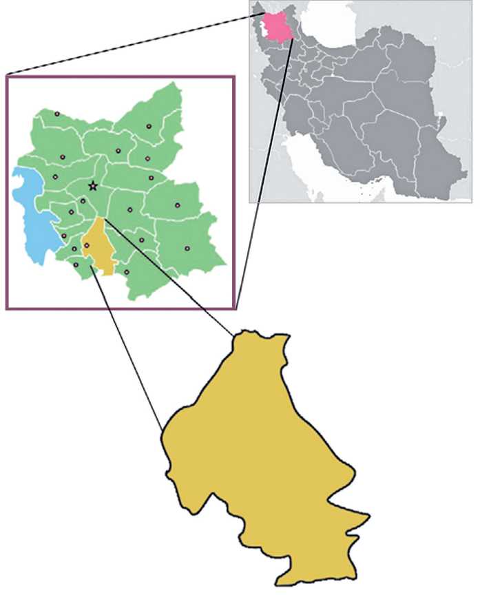
Fig. 1. Location of the Maragheh county (after Sattarnaejad et al. , 2020. P. 399)
Ruyin-Dej is located in the Azerbaijan region, within the Maragheh county. During the middle Islamic centuries, the province of Maragheh included Maragheh, Ba-najoun, Hashtroud, Dizgeroud, and Gavdoul (fig. 1). The approximate current extent of this province includes the counties of Maragheh, Bonab, Ajabshir, Hashtroud, and Malekan. Geographically, this area is divided into two parts: the mountainous regions (the slopes of Sahand Mountain) and the plains areas. Residential sites generally formed in the plains, while historical fortresses were predominantly established in the mountains. Based on the results of archaeological surveys in the mountainous areas of this region, seven historical fortresses have been reported so far. Therefore, it is likely that the location of Ruyin-Dej was also in the mountainous areas of Maragheh.
A close examination of the table above reveals that the known historical fortresses of present-day Maragheh are characterized by features such as being located in mountainous areas, proximity to water sources, and defensive walls. However, based on descriptions of Ruyin-Dej found in Islamic-era historical records Ruyin-Dej possesses unique characteristics that distinguish it from many other fortresses in the North-Western Iran (Azerbaijan Province – cave, Amid Garden, Seljuk Atabegs, River).
The significant characteristics of Ruyin-Dej make its location much more likely to correspond with Qizlar Qalasi compared to other fortresses. The distance between historical sites is a crucial factor in identifying the locations of historical Toponyms. According to the texts, the distance of this fortress from Maragheh is approximately 3 farsakhs (farsakh is a unit of distance measurement, roughly equal to 6 km). If each farsakh is considered to be approximately 5 to 6 km, the total distance from Ruyin-Dej to Maragheh would be about 15 to 18 km. This close proximity to the city center allowed the Atabegs to quickly reach the Ruyin-Dej in times of insecurity. Among the castles surrounding Maragheh, only Qizlar Qalasi is located approximately 14 km from the city. Other castles are situated at greater distances. Additionally, access from the city to Qizlar Qalasi is much easier compared to other fortresses. The route between Maragheh and Malekan, as well as other cities in West Azerbaijan Province, especially ancient Shiz, passes near this castle. Furthermore, the presence of certain characteristics shared between Ruyin-Dej and Qizlar Qalasi strengthens the possibility that Qizlar Qalasi might actually be Ruyin-Dej. However, to confirm this location, all existing cultural evidence must be analyzed.
Given that no archaeological excavations have been conducted at the Qizlar Qalasi site so far, the only reliable evidence for determining the chronology and the function of this site is the remaining surface evidence. During the author’s scientific visit to the Qizlar Qalasi site, archaeological artifacts and evidence were identified on the surface, which are of significant importance for the studies of the mentioned fortress. These surface artifacts include parts of the defensive fortifications, internal installations of the fortress, and cultural findings, particularly pottery.
The fortress is situated atop a relatively high rocky mountain, with steep and rugged slopes on three sides. This type of mountain fortress has a size dependent on the natural terrain of the mountain, showing no fixed or uniform design ( Pazuki , 1997). Consequently, the structure of Qizlar Qalasi follows the mountain’s topography, with defensive fortifications created to suit the site. The mountain leads to valleys on three fronts; however, the inhabitants of the fortress built a stone wall around the entire structure to enhance its strength and improve its defenses. The wall has an irregular shape, following the natural contour of the mountain. The main materials of the wall are rubble stones from the rocky bed of the site, which are utilized in two forms: drystone and rubble stone with lime mortar (fig. 2). The construction methods vary in different parts of the fortress, depending on the natural features of the site and the level of permeability into the fortress. For instance, due to the gentle slope of the western front, the wall is made with lime mortar, whereas on the other three fronts, which have steep mountain slopes, the wall is built with drystone. The northern front’s drystone wall is constructed with large stones of various sizes, with some measuring 40×60×90 or 40×50×70 cm ( Molazadeh, Mohammadi , 2000. P. 27).
A surface survey of the site revealed several identifiable sherds. These sherds are considered highly significant for establishing the relative chronology of the site. Since no archaeological excavations have been conducted at the site thus far, the dating of this site is primarily based on surface findings. The identified sherds mostly belong to the pre-Islamic historical period and the middle Islamic centuries. Islamic-era pottery, found in the form of dishes and bowls, indicates their belonging to the middle Islamic centuries through comparison with those from identified regional and extra-regional sites (fig. 3).
4. Discussion
Undoubtedly, historical documents are among the most reliable sources for reconstructing the spatial organization of cities and locating historical sites. These documents are highly effective in identifying the developments related to the formation, growth, expansion, continuity, or destruction of a city ( Karimian, Rahimnejad , 2017. P. 82). Historical documents serve as a powerful tool for precise and documented analyses by archaeologists ( Neyestani, Taghavi , 2010. P. 131). Utilizing these sources and archaeological studies, many remnants of cities have been discovered. In the northwestern Iran, the remains of cities such as Shiz, Ojan, Varsan ( Pouri-anezhad et al. , 2020) and Barzand ( Sattarnezhad et al. , 2023) have been identified
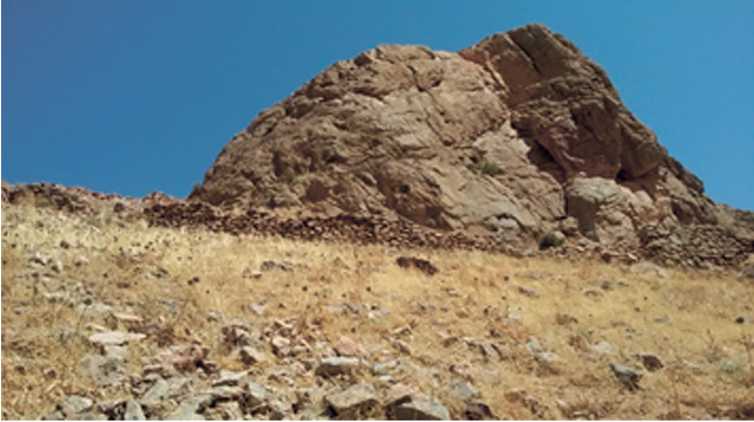
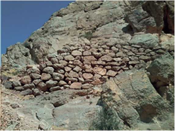
Fig. 2. Structure of the defensive wall of the fortress through Islamic-era written sources and archaeological activities. Several fortresses in the region are mentioned in Islamic-era sources, with one of the most notable being Ruyin-Dej. In analyzing the location of Ruyin-Dej, evidence obtained from archaeological findings was compared with historical data, significantly aiding in the identification of the fortress’s location.
According to Islamic-era written sources Ruyin-Dej was located in the Azerbaijan region and Maragheh province ( Qazvini , 1994. P. 613). This fortress served as the seat of the Atabegs’ rule in Maragheh, where they took refuge during times of insecurity.
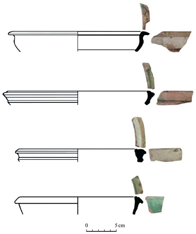
Fig. 3. Sherds from the Qizlar Qalasi site in Maragheh
However, prior to this research, the existence of the fortress in Maragheh province remained unknown. To establish a suitable theoretical basis for locating Ruyin-Dej, historical written sources were initially consulted and subsequently compared with archaeological evidence. Based on historical texts, Ruyin-Dej was situated in Maragheh province ( Banākati , 1969. P. 201).
During the Middle Islamic period, the province of Maragheh generally encompassed the areas of Maragheh, Bonab, Ajabshir, Malekan, Miandoab, and Hasht-roud. This region held significant political importance during the rule of the Atabegs of Azerbaijan and the Ilkhanate Mongols. The rulers of these dynasties carried out various developmental activities in the area. Archaeological surveys in this region have identified evidence of historical fortresses.
The fortresses in the northwest region of Iran are generally built in mountainous areas and on elevated parts of the mountains, making access to them very difficult. Given the common location choice for fortresses in the region, it appears that Ruyin-Dej was also constructed on the elevated parts of the mountains in the area. Due to its political importance, some historical events associated with Ruyin Dej have been recorded in Islamic-era written sources. This fortress had distinctive characteristics that set it apart from many of the notable fortresses in the region. One of the distinguishing characteristics of its location, compared to other fortresses, is its distance of 3 farsakhs from the political center of the Atabegs of Maragheh. The short distance between the political center and the fortress allowed for easy refuge from the city to the fortress in times of insecurity, facilitating more effective defense against enemies. This proximity was highly significant for the Atabegs, who thus endeavored to select a fortress close to Maragheh. Among the historical fortresses in the region, only the Qizlar Qalasi site is closer to the urban center than other fortresses. This fortress is located approximately 18 km south of Maragheh, along an important route connecting Maragheh to the southern cities. It is designed with significant size and intelligent defensive structures, making it an important site. The fortress is larger than other satellite fortresses and has thicker walls. Surrounding this fortress, the full-flowing Mordaq River runs, originating from the southern slopes of Sahand Mountain and flowing into Lake Urmia. Many settlement sites formed along this river, whose existence appears to greatly depended on the fortress. This fortress was considered the only significant defensive center in the area and served as a suitable place for refuge and defense during times of insecurity. One of the prominent features of the environmental landscape of Qizlar Qalasi is the presence of a natural and ancient cave called «Kabutar (Pigeon) Cave». This cave is one of the largest in the region, with very deep wells, and archaeological evidence confirms it was inhabited. In Qajar-era sources, this cave is referred to as «Kabutar Cave». This Persian word «kabutar» is equivalent to «pigeon» in English. The name derives from the pigeons found in its wells, which are occasionally hunted by local residents. Considering the vastness of its wells and the various accounts among the people, this cave has also been mentioned in historical sources. The Kabutar Cave in Maragheh is located on the banks of the Mordaq River. Archaeological soundings in this cave have uncovered evidence of habitation. Qazvini, in his book «Athar al-Bilad Akhbar al-Ibad», describes a cave located one farsakh from Ruyin Dej: «There is a well one farsakh from Ruyin Dej from which many pigeons emerge, and hunters set traps near it to catch numerous pigeons. The bottom of the well remains undetectable. It is said that someone was lowered into the well with 500 cubits of rope tied around him, but he still didn’t reach the bottom…» (Qazvini, 1994. P. 599). It appears that during Qaz-vini’s visit to the region, he traveled along the banks of the Mordaq River and reached Kabutar Cave from the village of Amir (Amirabad) after visiting the Ruyin Dej fortress (fig. 4). Therefore, the presence of pigeons in this cave confirms its location as Kabutar Cave near the village of Tazekand in Maragheh.
As previously mentioned, the cave referred to by Zakariya Qazvini is actually Kabutar Cave near the village of Tazekand in Maragheh. In the aerial map above, the area between Qizlar Qalasi and the cave includes a village named Amir located among fruit orchards. Islamic-era sources refer to a well-known garden named Amir or Amid near Ruyin Dej. Given that the village of Amir is located among fruit orchards and the similarity in names between Amir and Amid, it seems likely that the garden referred to is actually the village of Amir. Today, this village is completely surrounded by fruit orchards. It is located approximately 4 km north of Qizlar Qalasi.
The water needed for the fortresses was generally supplied through springs or pipes. The water source for the inhabitants of Ruyin Dej was provided by a spring in the mountain opposite the fortress (Ibid. P. 613). Consequently, there should be remnants of a tall mountain with a spring flowing at its base opposite Qizlar Qalasi. According to archaeological surveys in the surroundings of Qizlar Qalasi, evidence of a spring has been identified. This spring is located at the base of the mountain, opposite the fortress. According to local accounts, the spring water was directed into the fortress using clay pipes. Thus, the fortress’s water supply came from this spring, and remnants of the clay pipes can still be found in some parts today (fig. 5).
Based on the information provided, the existing evidence suggests that the best site containing the remains of Ruyin Dej is Qizlar Qalasi. The archaeological evidence present in the fortress also provides reliable data regarding this location identification. Qizlar Qalasi is significantly larger than the other six fortresses in the region. The defensive walls are built very thick, and the fortress is surrounded by cliffs on all four sides. Consequently, capturing the fortress would have been extremely difficult. The chronology of surface pottery and the architectural structure of the site indicate that the fortress was first used during the pre-Islamic historical period and later reoccupied in the middle Islamic centuries, especially during the Seljuk period. The settlement during the Seljuk period in the fortress was very significant, with most of the Islamic-era pottery belonging to this era. Therefore, during this period, the fortress was used as a defensive center against invasions. The shorter distance between the fortress and the existence of a communication route between the fortress and the city center, along with the relative similarity of sherds from the site to those obtained from the excavations of the Kabud-Modavar site, suggest that the pottery of Qizlar Qalasi was made in the city of Maragheh.
During the middle Islamic centuries, Maragheh was governed by the Seljuk Atabegs. The Atabegs of Maragheh built tomb monuments around the city and constructed strong fortresses in the mountainous areas for their security. The most important fortress was Ruyin Dej. During invasions, this fortress was particularly significant due to its proximity to the city. When the Khwarazmians and Mongols
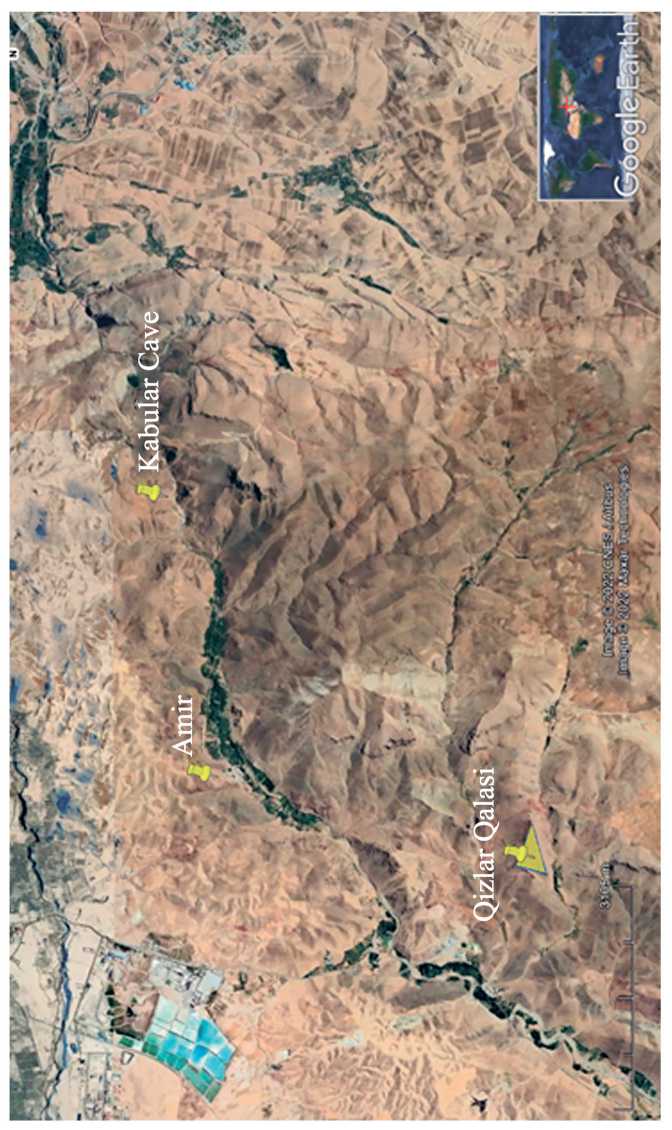
Fig. 4. Distribution of sites along the banks of the Mordaq River
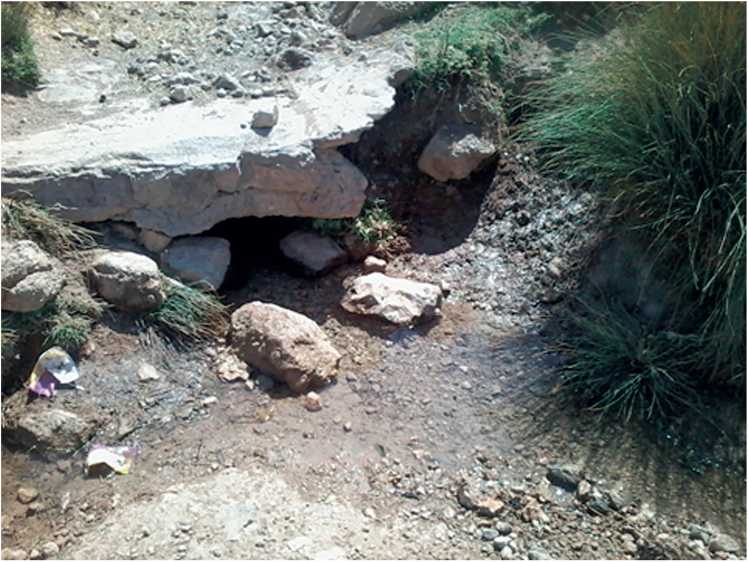
Fig. 5. An example of a water transfer channel attacked Maragheh, the Atabegs took refuge in this fortress. Despite prolonged resistance, the fortress was eventually captured (Rawandi, 1985. P. 245). The last ruler of the Atabegs who resided in this fortress was Salafeh Khatun. Because the fortress was governed by a woman, it became famously known as «Qizlar». Today, there is a belief among the people that the Qizlar Qalasi fortress was ruled by a woman, hence the name «Qiz», meaning girl. Therefore, a comparative study of all the remaining evidence indicates that the most probable location that contains the remains of Ruyin Dej is the site of Qizlar Qalasi. Based on the available information about this fortress, our understanding of the architectural structure of the Atabegs’ defensive fortifications in Azerbaijan has increased.
5. Conclusion
As stated above, Ruyin Dej was one of the important fortresses in the province of Azerbaijan during the Atabeg period, with the last ruler being Salafeh Khatun. The general evidence for locating Ruyin Dej includes the rule of Khatun, its distance of 3 farsakhs from Maragheh, a river flowing on one side of the fortress, a mountain, a spring, and the nearby Kabutar Cave. It is evident that there should be evidence of a historical fortress with a Seljuk-era settlement around Maragheh. Archaeological evidence has identified that the Qizlar Qalasi (Fortress of the Girl) is located near the city. Over time, traces of architectural structures have still remained on the surface of this fortress. Based on the pottery sherds, the relative chronology of the site generally belongs to the Pre-Islamic historical period and the middle Islamic centuries. This fortress became known as Qizlar and according to local oral traditions, it was once ruled by a queen named Khatun. A comparative study of these findings with evidence from the Qizlar Qalasi site suggests that this fortress is actually the same as Ruyin Dej. During his travels from Maragheh, Qazvini visited this fortress, continued along the Mordaq river valley, and also visited Kabutar Cave.