Mapping of the Solovetsky Islands in XVI−XVII centuries

Author: Bykova Marina
Journal: Arctic and North @arctic-and-north
Section: Geography, Ecology
Article in issue: 2, 2011.
Free access
The history of the geographic descriptions of Solovki closely related with the history of research of the Arctic Region by Russian and foreign seaman. The analysis of 34 ancient maps of the White Sea in XVI−XVII centuries led to the following conclusions. At first we meet the Solovetsky Islands in the map of Muscovy dated by 1537 year, compiled by A. Widom according to the boyar I.V. Lyatsky data. Most of maps of XVI−XVII centuries were made by Western Europe, British and Dutch cartographers. Both own observations of authors and maps of their predecessors and the Russian cartographic sources were used in compilation. But most of them didn’t survive. Most cartographers of XVI−XVII centuries like S. Herberstein, C. Munster, W. Borro, P. Bertius, G. Gerritsen, W. Blau, J. Tiriton, etc. denote Solovki in their studies. Solovetsky Islands are marked on 25 of the 34 reviewed maps of XVI−XVII centuries. Solovki on maps of XVI−XVII centuries have different toponyms: «Soloffki», «Solofki», «Solowka Insvla», «Solofka», «Soloffky», «Solffky», «Soulofki», «Solafka», «Senloski». Islands of the group of Solovetsky archipelago are marked only on a few maps. Anser («Angra» − 1614 H. Gerritsen, «Anger» − 1612 I. Massa, 1635 J. Blau, 1660 F. de Wit), Zayatsky («Satska» − 1612 I. Massa, 1635 J. Blau), Muksalma («Muksama» − 1635 J. Blau). Most of maps of XVI−XVII centuries give an incorrect location of Solovki in the White Sea basin.
Old maps of Solovki, the initial stage of mapping, the history of research
Short address: https://sciup.org/148320516
IDR: 148320516 | UDC: 528.92 (470.116).”15/16”(045)
Text of the scientific article Mapping of the Solovetsky Islands in XVI−XVII centuries
The history of the cartographic description Solovetsky Islands is closely linked with the history of development of the Arctic region and the Russian foreign seafarers. The first scientific study of the Solovetsky Islands is connected with the name of Academician II Lepekhina, who led the expedition to the White Sea in 1771, surveyed the Solovetsky archipelago. However, the geographical study of the Solovki happened to the XVIII century. To have survived a large number of the cartographic materials that indicates that over the XVI-XVII centuries carried out active research Solovetsky archipelago, the results of which were his numerous maps or drawings.
An analysis of 34 ancient maps White Sea XVI-XVII centuries. led to the following conclusions about the initial phase of the study of the geographic and mapping Solovetsky archipelago.
Solovetsky Islands meet for the first time on a map of Muscovy in 1537, compiled by A. View information Boyar IV Lacki, who fled from persecution in Lithuania Ivan IV (Fig. 1).
Pic. 1. The Solovetsky Islands on the map of Vida Lyatskiy. 1537.
Most of the maps of the XVI-XVII centuries. The Western European performed by British and Dutch cartographers. When drawing up their own observations were used as the authors of the maps of their predecessors, and the Russian cartographic sources, most of which have survived.
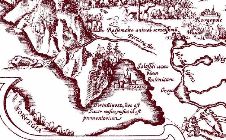
Most cartographers XVI-XVII centuries. (S. Gerberstein (Fig. 2), S. Muenster, U. Borro, P. Bertius,
G. de Yoda (Fig. 3), H. Gerrits, W. Blau, I. Tiriton etc.) Indicate in their writings of Solovki. Of the thirty-four analyzed cards Solovetsky Islands are marked by twenty-five. It is a testament to the fact that most of the navigators and cartographers of the time were aware of the geographical area.
Pic. 2. The Solovetskiy Arhipelago on the map of S. Gerbershtein 1546.
Pic. 3. The Solovki on the map G De Iode. 1570.
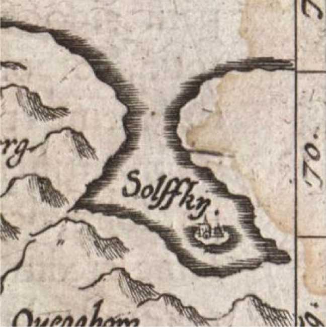
The Solovki on the maps of XVI-XVII century has different place names: «Soloffki», «Solofki» 4), «Solowka Insvla», «Solofka», «Soloffky», «Solffky», «Soulofki» (Pic. 5), «Solafka», «Senloski».
(Pic.
Pic. 4. The Solovki on the map S.Munster 1598
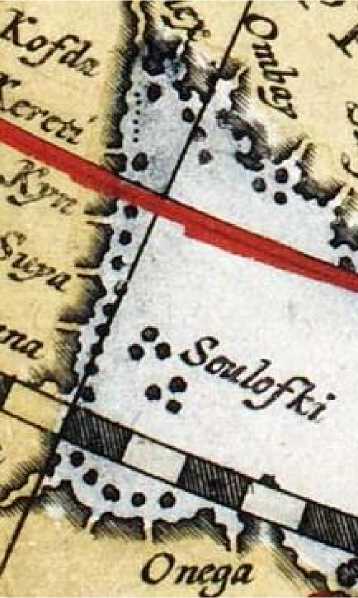
Pic. 5. The Solovetskiy Islands on the map T de Bri. 1598
Some islands in the group Solovetsky Archipelago, marked only by a few maps: Anzere («Angra» -1614 G. Gerrits (Pic. 6); «Anger» - 1612 J. Mass, 1635 J. Blau (Fig. 8), 1660, F. de Wit (Pic. 7); Zayatsky («Satska» - 1612 J. Mass, 1635 J. Blau (Pic. 8); Muksalma («Muksama» - 1635 J. Blau (Pic. 8).
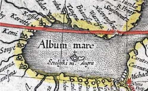
Pic. 6. Island Anzer on the map
G. Gerritsa. 1614
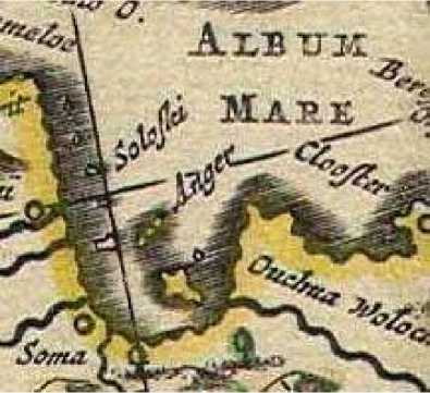
Pic. 7. Island Anzer on the map F de Vita.
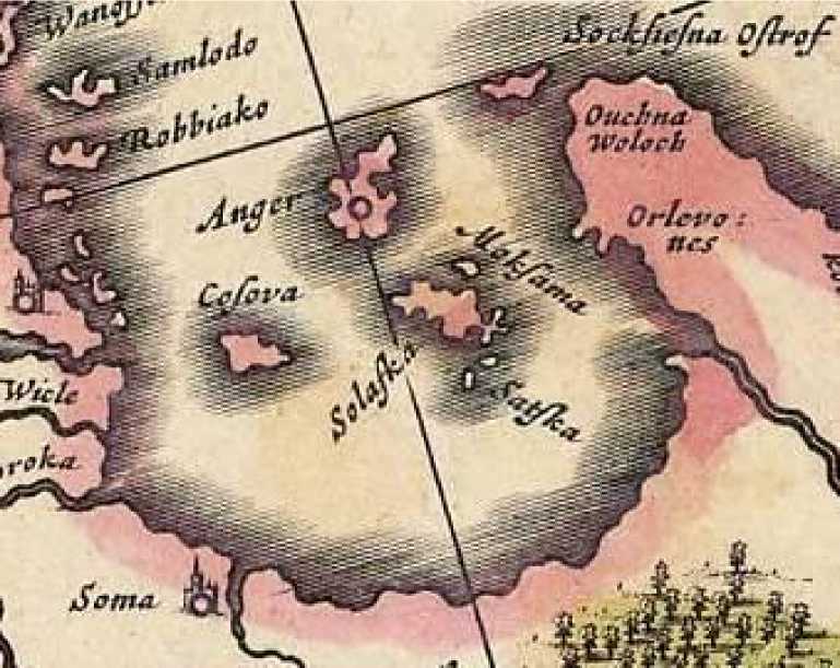
Pic. 8. Zayatsky Island on the map J. Blau. 1635
Location of Solovki in the White Sea basin on the most maps of the XVI-XVII century is writtern wrong (Pic. 9).
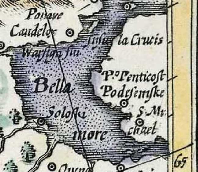
Pic. 9. The Solovetskiy Islands on thre map of G.Merkatora. 1607.
On the maps of the White Sea for the first time appears in the XV century, Solovetsky Islands - in the XVI century. During the XVI-XVII centuries in the drawings and maps of the White Sea basin in the most cases portrayed the Solovetsky archipelago with Solovetsky monastery not only as a kind of outpost of Christianity and nationhood in Northern Russia, but also as a well-known geographic feature of the Russian North.
Published maps, which were used in the work:
-
1. Map of Muscovy Anthony Vida. 1537 Internet-project "Russian North and the White Sea on old maps." URL: http://museum.solovki.info (date of access: 12.02.2011).
-
2. Map Gerberstein. 1546 / / BA Rybakov Russian Muscovy card XV - beginning of XVI century / BA Fishermen. - M.: Knowledge, 1974.
-
3. Map G. de Yoda «Septentrionaliv regionum Svetia, Gothia, Norvegia, Dania et terrarum adiacetium recens exactaque descriptio». 1570. Internet-project "Kola map." URL: http://www.kolamap.ru (date of access: 12.02.2011).
-
4. Map of Munster «Gemeine Beschreibung aller Mittnachtigen Landern als Schweden, Gothen, Norvegien, Dennmarck, u». 1598. Internet-project "Kola map." URL:
-
5. Map T. de Bry «The Arctic and Scandinavia». 1598. Internet-project "Kola map." URL: http://www.kolamap.ru (date of access: 12.02.2011).
-
6. Map of Russia 1614 edition of Colonel Deyriarda. / / Maps Russia 1614, vol. 1 1 / Gessel Gerritsen. Is dedicated to Tsar Mikhail Fedorovich, printed in Amsterdam, studio of Blau, autograph on Prince FB Godunov and 2 / P. Deir Arda. - 1901.
-
7. Map F. de Wit «World & Continents». 1660. Internet-project "Kola map." URL: http://www.kolamap.ru (date of access: 12.02.2011).
-
8. Map J. Blau «Svecia, Dania, et Norvegia, Regna Europae Septentrionalia». 1635. Inter-noproject "Kola map." URL: http://www.kolamap.ru (date of access: 12.02.2011).
-
9. G. Mercator Map «Svecia, et Norwegia». 1607. Internet-project "Kola map." URL: http://www.kolamap.ru (date of access: 12.02.2011).
(date of access: 12.02.2011).
References Mapping of the Solovetsky Islands in XVI−XVII centuries
- Map of Muscovy Anthony Vida. 1537 Internet-project "Russian North and the White Sea on old maps." URL: http://museum.solovki.info (date of access: 12.02.2011).
- Map Gerberstein. 1546 / / BA Rybakov Russian Muscovy card XV - beginning of XVI century / BA Fishermen. - M.: Knowledge, 1974.
- Map G. de Yoda «Septentrionaliv regionum Svetia, Gothia, Norvegia, Dania et terrarum adiacetium recens exactaque descriptio». 1570. Internet-project "Kola map." URL: http://www.kolamap.ru (date of access: 12.02.2011).
- Map of Munster «Gemeine Beschreibung aller Mittnachtigen Landern als Schweden, Gothen, Norvegien, Dennmarck, u». 1598. Internet-project "Kola map." URL: http://www.kolamap.ru (date of access: 12.02.2011).
- Map T. de Bry «The Arctic and Scandinavia». 1598. Internet-project "Kola map." URL: http://www.kolamap.ru (date of access: 12.02.2011).
- Map of Russia 1614 edition of Colonel Deyriarda. / / Maps Russia 1614, vol. 1 1 / Gessel Gerritsen. Is dedicated to Tsar Mikhail Fedorovich, printed in Amsterdam, studio of Blau, autograph on Prince FB Godunov and 2 / P. Deir Arda. - 1901.
- Map F. de Wit «World & Continents». 1660. Internet-project "Kola map." URL: http://www.kolamap.ru (date of access: 12.02.2011).
- Map J. Blau «Svecia, Dania, et Norvegia, Regna Europae Septentrionalia». 1635. Inter-noproject "Kola map." URL: http://www.kolamap.ru (date of access: 12.02.2011).
- G. Mercator Map «Svecia, et Norwegia». 1607. Internet-project "Kola map." URL: http://www.kolamap.ru (date of access: 12.02.2011).
