Methodology for assessing the transport security of the territory for the availability of social services

Author: Kuratova Elvina Stepanovna
Journal: Economic and Social Changes: Facts, Trends, Forecast @volnc-esc-en
Section: Branch-wise economy
Article in issue: 5 (35) т.7, 2014.
Free access
The formation of a rational transport network and the development of vehicles should be marked by the achievement of socio-territorial justice, which is understood as a guarantee of transport accessibility of social services, increase and economy of man’s free time, reduction in the degree of uncertainty of economic activity in the part that depends on transport factors. According to the author, the priorities of the assessment of transport security include the duration of the trip from the settlements to the centers of social services and year-round transportation. Each type of social services has normative values of transport accessibility, corresponding to the needs of a particular region, and they are the basis for strategic planning in the services sector. For instance, the standard time for provision of emergency medical aid is 40 minutes. The level of transport discrimination is defined as the proportion of the population living outside the standard time. The author proposes a formula for determining the weighted average costs of time that a transport user needs for reaching a certain destination (e.g., hospital, school, etc.) from any other departure point...
Transport security, weighted average costs of time, availability and rise in the cost of public services
Short address: https://sciup.org/147223651
IDR: 147223651 | UDC: 338.47:656:338.46 | DOI: 10.15838/esc/2014.5.35.21
Text of the scientific article Methodology for assessing the transport security of the territory for the availability of social services
Transport creates conditions for economic independence and development of RF subjects, including municipalities of districts, villages and settlements. Economic entities only benefit from transport infrastructure development. Transport remoteness of many settlements from centers of social services is one of the most important factors affecting the level of life of the population and expenditures of budgets and production.
The process to form a rational transport network and develop vehicles involves achievement of two goals:
-
1) socio-spatial justice, understood as a guarantee of transport accessibility of social services (education, culture, medicine, trade, consumer services, passenger traffic, etc.), growth and economy of people’s free time [2];
-
2) decrease in the degree of uncertainty (risk) of economic activity in terms of transport factors. Reduction of time spent on freight service is of importance.
The problem to increase “transparency” of territorial levelling should be addressed through the improvement of methods of formal registration of remoteness indicators. The indicators of transport security are relevant in the standards of budget costs appreciation, used for the allocation of funds to support administrative-territorial entities of different level (from subjects to settlements) by means of fiscal capacity adjustment.
The priorities of transport security assessment aimed at the accessibility of social services include:
-
• taking timing into account when moving from settlements to centers of social services;
-
• year-round transportation.
The transport availability indicator can be defined as weighted average costs of time required for a vehicle user to reach a certain point of destination (medical and institutions, schools, educational institutions, clubs, shops, settlements, etc.) from any other departure point (settlements, etc.).
All types of services have normative values of transport availability, which should correspond to the needs of a particular region. It is important to consider them while developing each of the services.
For instance, the standard time for provision of emergency medical aid is 40 minutes, which corresponds to a 30-km distance that a medical ambulance passes. In the services sector the level of transport discrimination is defined as a share of the population living outside this normative time.
According to the preliminary calculations, the discrimination level is significantly lower in urban districts than in municipalities and settlements. The standards of transport availability should be taken into consideration when deciding on the location of new schools, tourist camps and other facilities.
The levels of transport provision and transport availability are the same for passenger traffic services. Timetables help transport users estimate the time from a point of departure to a point of arrival and choose means of transport, a trip and a route that satisfy their needs (time, money, a service level, etc.).
Let us consider the issues of internal transport provision of the territory when determining the transport availability of settlements.
The settlements have not usually developed real approaches to the formation of a transport network due to external and internal factors.
The external factors include underestimation of the role of transport infrastructure and the residual principle of its funding. The internal factor is associated with a diversified composition of transport infrastructure, a lack of a single customer, maintenance of transport infrastructure by different agencies, different standards and approaches to the development of transport infrastructure in different departments (agriculture, forestry, oil, gas industry, etc.).
Transport accessibility of settlements is characterized by remoteness and presence of obstacles in the traffic road. Figure 1 shows that remoteness is defined through the indicators of the distance between settlements and settlements centers, and then, in turn, between them and district centers, railway stations, centers of RF subjects. One should also take into account remoteness (closeness) from main road and rail routes, types of the upper surface of roads, seasonal roads (winter roads), ensuring communication between settlements even in winter, water crossings and bus service.
The location of settlements at highways, roads and in the areas of their immediate impact is the most important factor of the transport and geographic position determining opportunities for further growth and development.
The livelihood of the population depends on seasonality of transport connections. In spring and autumn at the time of freeze-up and thaw traffic service becomes problematic. In summer rivers are crossed by ferries and boats, in winter – by cars. Constant communication is only available in winter due to winter roads and ice crossings. Annual maintenance and upkeep of winter roads and ice crossings are expensive.
Figure 1. Diagram of spatial organization of transport

Settlement Settlement center District center
The bus route network and commuter trains reduce the temporary link between settlements. The 30 km distance from the “ordinary” settlement to the settlement or district center (a 6 hour “tourist” trip) includes walking. Small and medium-sized towns are covered by bus service only if the route is mapped through them or they are at a distance of not more than 5 km (a 1 hour walk). The problems in this sphere are the following: intensity of bus and rail links, number of trips, involving loss of time on waiting. People have to get to a place of destination by a car share.
The presence and nature of obstacles, leading to a decrease in the rate and seasonality of transportation vary greatly by municipalities. Taking into account the parameters of transport provision, one can distinguish municipalities with year-round (with minor exceptions), limited and discriminatory (in bad road conditions) transport links between settlements.
Year-round transport link provides transit communications through the territory of settlements. They are covered by railway, road and other communication networks. This may also include the settlements, which centers are not covered by a route network, but they are located near main roads and there are roads leading to federal and local highways.
Limited transportation is characterized by the presence of river obstacles that require maintenance of pontoons and ice crossings, purchase of ferries and boats; it is also characterized by a low level of development of the transport network (predominance of winter roads).
The territory maintenance requires investment support.
Discriminatory transport connection is characterized by a small share of hard-surface roads, a great length of winter roads and a lack of river crossings. These settlements also need investment support.
To calculate the weighted average cost of time within settlements, local systems, districts, the capital, etc., taking into account the presence/lack of bus, rail and other types of transport connection and the average speed of vehicles and walking (of a horse) we have suggested a formula1:
n
£ (t a X la + t n X l n + tr W X l, w )
T = ----------------------- in ,
£ (l a + l n + l r/w )
n is a number of settlements in the region;
l а is a length of hard surface roads from the settlement n to the center of social services, the settlement, the local system, the district, the capital, etc.;
t а is time costs associated with the trip by bus or other vehicles;
l п is a length of dirt roads from the settlement n to the center of social services, the settlement, the local system, etc.;
t п is time required to get to the place of destination on foot (by horse);
lr/w is a length of the railway from the settlement n to the center of social services, the settlement, the local system, the district, the capital, etc.;
tr/w – time costs associated with the trip by train.
To assess transport security in the Komi Republic the given study uses the formula to calculate the weighted average cost of time. The calculation includes all settlements (more than 700), takes into account the distance from the settlements to regional centers, state of communication routes, obstacles to year-round communication, transport vehicles, walking (horse-drawn traffic), speed of movement and other factors. The assessment is based on the data on the administrative-territorial division of the Komi Republic, data on the condition of roads, transport enterprises – on route networks, winter roads, water crossings, vehicle characteristics, speed of their movement and other sources.
The main land transport, connecting the settlements of the Komi Republic with the centers of municipalities, is motor transport.
The state network of public roads is divided into federal – within the boundaries of the republic (0.3 thousand km) and territorial – within districts (6.7 thousand km), of which 0.9 thousand km of roads are dirt roads [1]. Most settlements have local dirt and winter roads.
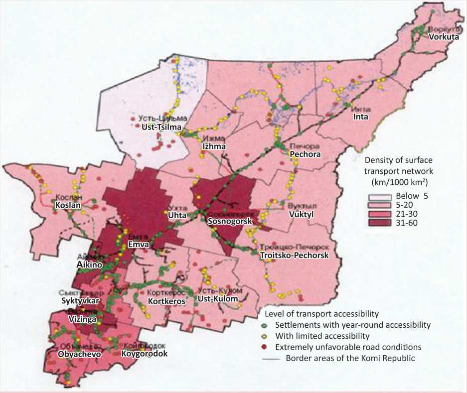
Figure 2 shows that the settlements with year-round accessibility are covered by a route network; the settlements are compactly located and have ferry and pontoon crossings. It is efficient to build local roads with the access to federal and territorial roads leading to regional centers and the capital and railway stations.
The group of settlements with limited accessibility is characterized by the presence of river obstacles that require maintenance of pontoons, ice crossings, the purchase of ferries, boats, boats and by a very low level of development of the transport network (predominance of winter roads). This is a rather large group that needs investment support for infrastructure equipment of its territory. The settlements with discriminatory accessibility are characterized by a great length of winter roads, a lack of river crossings, aggravating the socio-economic situation of the population. This is the most remote settlements that require significant financial investments in the transport network.
Figure 3 discloses transport discrimination of the population in Ust-Tsilemsky (17 hours), Vuktylsky (15 hours), Usinsky (12 hours), Pechorsky (11 hours), Izhemsky (10 hours), Koygorodsky, Ust-Kulomsky, Intinsky, Udorsky and other districts.
To range districts by the types of transport accessibility we have used the time periods, characteristic of the Komi Republic ( table ).
Optimal transport accessibility implies the possibility to establish closer cultural and economic ties, joint use of resources and social infrastructure. High transport security is ensured by available railways and highways, good bus and other transport service, location of many settlements near the roads.
Acceptable transport accessibility involves the possibility to develop services and production. This group is characterized by a relatively well-developed network of surface roads. It includes the municipalities located near the railway and a small number of remote settlements. It demands the maintenance of the roads leading to highways and improvement of bus service.
Figure 2. Transport accessibility of settlements in the Komi Republic
Type of transport accessibility
|
Weighted average cost of time required to get to the center |
Accessibility |
Type |
|
0.1–2 hours |
Optimal |
I |
|
2.1–6 hours |
Acceptable |
II |
|
6.1–10 hours |
Limit |
III |
|
More than 10 hours |
Discriminatory |
IV |
Figure 3. Weighted average cost of time required for the population’s movement within certain districts of the Komi Republic
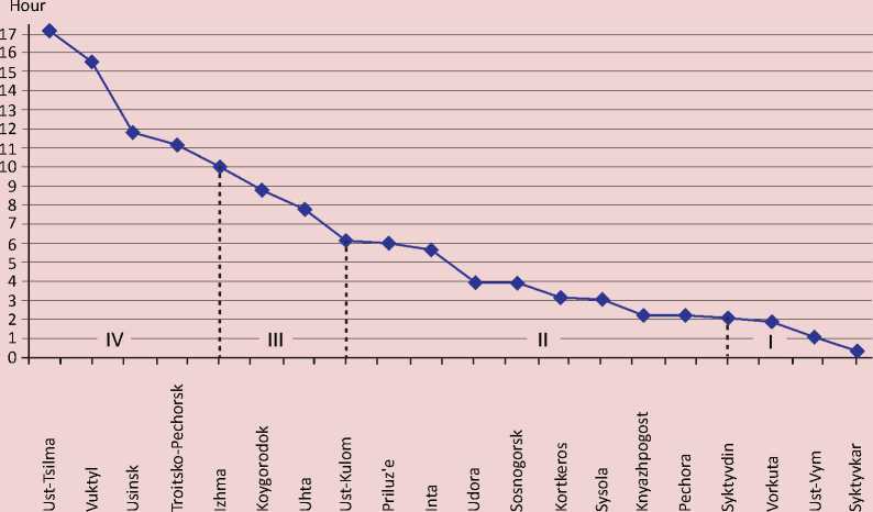
Limit transport accessibility presupposes a 6–10 hour time interval to get to the regional center. It is rural areas located far from the settlements. The most remote settlements of the municipality belong to the group “discriminatory accessibility” (10–18 hours).
The decrease in living standards in rural areas, rise in ticket prices, reduction and initial lack of bus routes, poor road conditions make it difficult for many villagers even to get to the regional center. And therefore it is important to develop all rural settlements regardless of their type and the number of residents and select key rural settlements, centers of social services.
As it has been noted, the differentiation of transport provision areas can be used for budgetary control and distribution of funds, allocated by the Fund of financial support for municipalities.
Figure 4. Transport adjustment of the potential cost of public services in the municipal districts of the Komi Republic
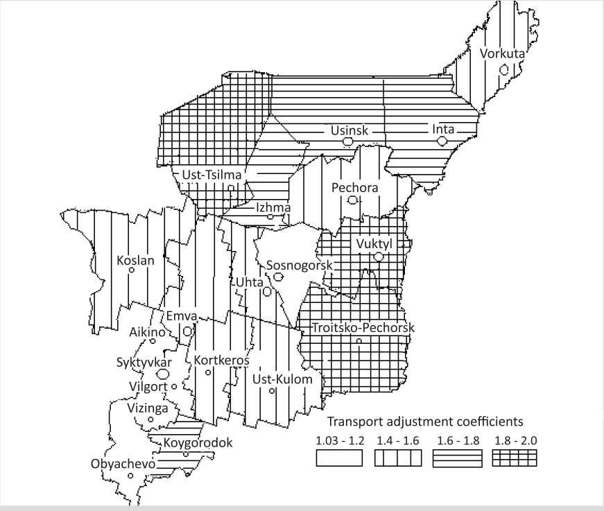
The rise in the cost of public services is calculated by means of the ratio of transport security К i = (1 / Тi ) , according to the formula:
K 1 + T i x ( 1 T m ) .
Figure 4 reveals that within the transport adjustment of the potential cost of public services in the municipal districts of the Komi Republic amounts to 1.03–2 points. The coefficients of transport provision and transport adjustment of budget services value have been calculated at the request of the Ministry of Finance in order to improve budgetary control and distribution of funds allocated by the Fund of financial support for municipal formations of the republic.
The quantitative assessment of transport security in the region has resulted in the following conclusions:
– the relevance of the assessment results is high due to the impact, which the rise in transportation prices has on the volume and cost of providing services to the population;
– the first assessment of the transport accessibility at the level of settlements that considers the influence of obstacles (the lack of hard surface roads, the gap in the transport network associated with the river obstacles that results in the limited bus routes and the level of highways) has elaborated on the idea of remoteness and connectedness of settlements within districts of the RF subject; the assessment results have revealed the predominance of territories with limit and discriminatory accessibility.
It is possible to increase the social status and the efficiency of market processes in the economy of the Komi Republic only with government support for the development of the transport network. The main direction of the transport service enhancement is to strengthen the connection of the settlements with social service centers, villages, district centers, and the latter – with the capital and the nearest railway stations.
Cited works
-
1. Statistical Yearbook of the Republic of Komi, 2013: Statistical Collection . Komistat. Syktyvkar, 2013. 440 p.
-
2. Transport Marketing . Ed. by V.G. Galaburda, Doctor of Economics, Professor. Moscow: Marshrut, 2006. 450 p.
References Methodology for assessing the transport security of the territory for the availability of social services
- Statisticheskii ezhegodnik Respubliki Komi, 2013: statisticheskii sbornik . Komistat. Syktyvkar, 2013. 440 p.
- Transportnyi marketing . Ed. by V.G. Galaburda, Doctor of Economics, Professor. Moscow: Marshrut, 2006. 450 p.
