New evidence of the late Neopleistocene peopling of the Lower Ob valley

Author: Zolnikov I.D., Anoikin A.A., Vybornov A.V., Vasiliev A.V., Postnov A.V., Zotkina L.V., Filatov E.A.
Journal: Archaeology, Ethnology & Anthropology of Eurasia @journal-aeae-en
Section: Paleoenvironment, the stone age
Article in issue: 1 т.49, 2021.
Free access
Short address: https://sciup.org/145146234
IDR: 145146234
Text of the article New evidence of the late Neopleistocene peopling of the Lower Ob valley
The available scientific data make it possible to assert that the settling of human paleo-communities in the polar zone of Eurasia began quite early, and most likely took place in several stages (Pitulko, 2016; Zolnikov et al., 2020). The earliest evidence of human habitation in the Asian circumpolar zone has been recorded in the Yakutia and Krasnoyarsk Territory, and corresponds to the period of 40–35 ka BP.
These are materials from archaeological and paleontological sites in the Lena and Yana river basins, as well as the mammoth remains with traces of butchering found in the mouth of Yenisei (Pitulko et al., 2016). In the European part of Russia, several archaeological sites of the same age have been reported from the Pechora River basin (Mamontovaya Kurya, Byzovaya); these sites are located close to the Arctic Circle (Pavlov, 2015). Until recently, the vast area of the Lower Ob basin situated between these regions remained a “blank spot” on the Paleolithic map of Eurasia. The northernmost site was Lugovskoye, aged 10.7–17.0 thousand years (according to calibrated 14C dates); the site was discovered in the early 2000s not far from Khanty-Mansiysk (Zenin et al., 2006; Leshchinskiy et al., 2006). The situation in the region has begun to change in the last five years, during which the area has been subjected to intense archaeological studies aimed at searching for prehistoric sites.
Since 2016, searches specifically for Paleolithic sites in the Lower Ob and its tributaries have been carried out by expeditionary teams from the Institute of Archaeology and Ethnography SB RAS (Novosibirsk). The theoretical basis of the research is the modern concept that there were no paleogeographic (e.g. glaciers and ice-dammed lakes) or climatic barriers that might have hindered human settlement in this area. An additional confirmation of these assumptions is the discovery of lithic artifacts of Paleolithic appearance on the riverbanks (Zolnikov et al., 2018). In 2017, in the north of the Khanty-Mansi Autonomous Okrug–Yugra, an archaeological team led by S.S. Makarov and A.S. Rezvy discovered the Komudvany site, aged 12.1–15.3 thousand years (according to calibrated 14C dates). This discovery shifted the known boundary of the ancient human settlement in the area 300 km northwards (Makarov, Rezvy, Gorelik, 2018). In addition, digital relief images have shown that there were valleys stretching through the Ural range, which indicates the possibility of direct migrations by Paleolithic humans from the Pechora Plain to the Lower Ob region (Zolnikov et al., 2020). During field studies in 2019–2020, new archaeological and scientific data were obtained, providing more comprehensive information on the early history of human settlement in the Northern Ob region, and clarifying the chronology and spatial boundaries of the early colonization of the circumpolar regions of Western Siberia.
Geological and geomorphological structure of the study region and determining the criteria for the search of Paleolithic sites
The area in the Lower Ob region investigated by the teams from the Institute of Archaeology and Ethnography SB RAS included the part of the river valley between the cities of Khanty-Mansiysk and Salekhard; however, the attention was focused primarily on a smaller portion of the valley within the boundaries of the Yamal-Nenets Autonomous Okrug, stretching from the village of Kazym-Mys to the village of Pitlyar. In its lower reaches, the Ob (between the villages of Peregrebnoye and Katravozh) is divided into two main branches: the western Malaya Ob; and the eastern Gornaya Ob, which then forms the Bolshaya Ob (Fig. 1). These two branches are separated by a wide (up to 50 km) floodplain with many channels. The banks of the Malaya Ob are mostly low—floodplains with rare erosional remnants; while the right bank of the Bolshaya Ob is high (up to 25 m and higher) and has a complex geological structure, which is not always reflected in the relief (Zolnikov et al., 2018, 2019). The basement for the terraces of this territory is the Middle Pleistocene glaciocomplex (over 130 ka BP) consisting of lacustrine-glacial “varved clays” and main moraines with outliers of alluvium, mainly sandy. The Middle Quaternary age of this glaciocomplex has been assessed by its overlying and underlying sediments. In the vicinity of Khashgort village, remains of small rodents were collected from intramoraine and submerged outliers, which provided the possibility of determining the Tobolsk complex of theriofauna (Borodin, Kosintsev, 2001). In a higher stratigraphic position, on midQuaternary moraines and “varved clays”, near the village of Shuryshkary, on the left bank of the Malaya Ob, there is a peat bog, for which a series of radiocarbon dates beyond the limits of the method has been generated; another set of 230Th / 234U dates of 133 ± 14 and 141.1 ± 11.7 ka BP has been obtained in St. Petersburg State University (Astakhov et al., 2005). Alluvium lenses in the “varved clays” and in the outcrops at the mouths of the Pyak-Yakha and Pichugui-Yakha rivers, at the latitude of the Arctic Circle, have produced a series of transcendent radiocarbon dates and several OSL-dates with an average value of 133 ka BP (Astakhov, Nazarov, 2010). Thus, the mid-Quaternary glaciocomplex includes the alluvial and lacustrine-boggy deposits of the first interglacial of the Upper Neopleistocene, with an age of ca 100–130 thousand years.
Notably, the roof of the Middle Quaternary glaciocomplex in the coastal sections either goes under the water’s edge or rises almost to the cliff tops. Most of these incisions of various depths were obviously formed at the stage of deglaciation of the last Middle Quaternary ice period in northwestern Siberia, which was accompanied by the release of waters from ice-dammed lakes. Runoff channels are especially apparent on the left bank of the Ob, in the form of a series of overdeepenings of up to 300 m (Zolnikov, Guskov, Martysevich, 2004). Along the deepest of these runoff paleovalleys, the Upper Quaternary hydro-network of northwestern Siberia was formed. The presence of incisions and lining fluvial sediments therein, formed at the stage of the ice-dammed lakes’ discharge, helps to explain the fundamental difference in the geological structure and age of deposits exposed by closely located digging trenches. It is noteworthy that fluvial sands and coarser detrital formations of the Late Glacial flood may occur at heights of 10, 20, or 30 m above the edge of the towpath, i.e., at the hypsometric marks that were never reached by the waters of the Ob. Therefore, the Ob alluvium could not have been deposited at the indicated heights. Depressions within paleo-incisions are often lined with gray clays or non-layered silts with a characteristic bog smell, sometimes stratified with solifluctional textures, scattered organic remains, or lenses of peat detritus.
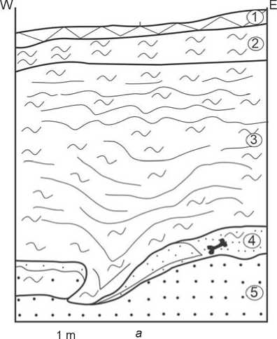
In the research area on the right bank of the Bolshaya Ob, a reference for characterizing the deposits of the first interglacial horizon of the Upper Neopleistocene is the section near Pitlyar, showing the Middle Quaternary glaciocomplex overlain by fluvial sands, covered with a layer of aeolian sands, the bottom and top of which are formed by thin paleosols (Fig. 2). For the upper sand layer, four OSL-dates were obtained, with an average value of ~78 ka BP (Astakhov, Nazarov, 2010). Alluvial sands of the Early Upper Neopleistocene often occur in the uppermost portion of the Middle Quaternary complex, in the lower part of coastal sections. These sands are distinguished by good washing, medium grain-size, and oblique and parallel subhorizontal bedding. Often, peat interlayers are noted in them, usually confined to the upper part. Floodplain facies are rare, and occur as parallel thin/medium interbedding of sands and silts, usually less than 1 m thick.
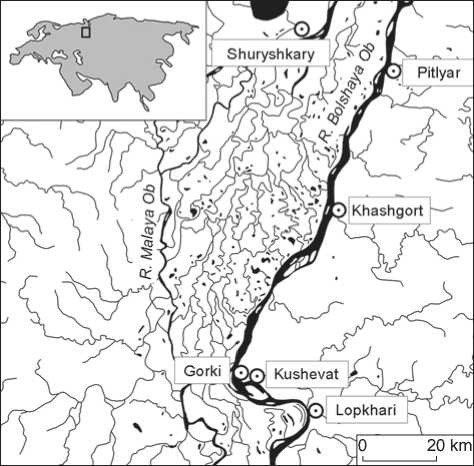
Fig. 1. The main area of the reconnaissance works in 2019–2020.
Deposits from the second stage of the Upper Neopleistocene, corresponding to the Zyryan Glaciation (90–60 ka BP) (Ibid.), whose boundary was located significantly further north than Salekhard, occur on the right bank of the Bolshaya Ob in the form of varvites, with maximum elevations above sea level not exceeding 60–70 m. For the top of a 10-m thick layer of varvites in the Pitlyar section (Fig. 2), two OSL-dates with an average value of ~73 ka BP are available. To the north of Salekhard, similar varvite formations in the Sangompan and Aksar sections are dated, respectively, to ~85 and ~90 ka BP (in the first case, there are four OSL-dates, in the second two OSL-dates) (Ibid.). The considered parallel-bedded stratum lies enveloping the alluvium or subaerial deposits without signs of erosion, which indicates the calm nature of the flooding of the Ob paleovalley by the waters of an ice-dammed lake. The top of this stratum, just as the top of the Middle Quaternary glaciocomplex, is characterized by numerous paleoincisions of various depths and widths, caused by the waters flowing from dammed lakes during deglaciation of the Late Quaternary glacier in the West Siberian Arctic.
The above-described deposits are cut into by the 2nd and 1st above-floodplain terraces of the Ob and its tributaries. The alluvium of the 2nd terrace consists mainly of well-washed fine- and medium-grained light gray sands with oblique and parallel-subhorizontal
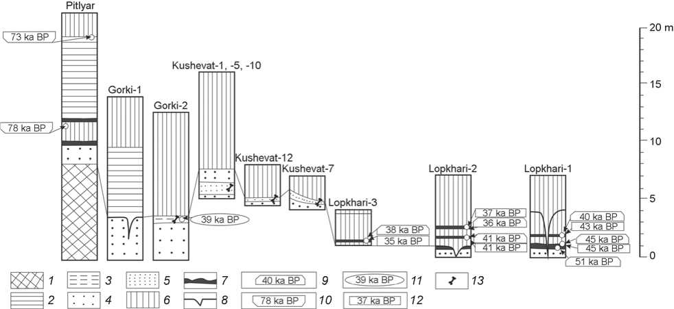
Fig. 2. Correlation pattern of the main sections of the Quaternary deposits in the Kushevat–Gorki–Lopkhari area.
1 – moraine diamicton; 2 – lacustrine-glacial varvites (“varved clays”); 3 – lacustrine-boggy deposits; 4 – alluvial sands of the paleo-Ob; 5 – alluvial sands of a shallow river; 6 – subaerial complex; 7 – paleosols; 8 – cryogenic wedges; 9 – 14C dates obtained at St. Petersburg State University; 10 – OSL-dates (after (Astakhov, Nazarov, 2010)); 11 – AMS-dates obtained by the Royal Institute for Cultural Heritage, Brussels; 12 – AMS-dates obtained by the Center for Collective Use of Geochronology of Cenozoic at the accelerator mass-spectrometer of the Budker Institute of Nuclear Physics of SB RAS, Novosibirsk; 13 – paleofaunal remains.
bedding, and shows signs of ascending ripples. The top of these sands usually rises several meters above the edge of the towpath. The rest of the 2nd terrace’s sections, visible in the coastal outcrops, includes aeolian (blown and overblown), deluvial, shallow-lacustrine-boggy and solifluctional deposits of the subaerial complex up to 5–10 m thick; this complex also covers the watershed areas not affected by the river waters. Exactly the sediments of subaerial origin aged 50–60 thousand years are the most promising for the detection of traces of Paleolithic humans, since the search for such evidence in the alluvium of the first Neopleistocene interglacial, and especially in the outliers of the Tobolsk alluvium, seems inexpedient at the current stage of research.
Kushevat
One of the areas identified as promising in terms of searching for Paleolithic sites was a right-bank section of the Kushevat channel of the Bolshaya Ob River within the abandoned village of Kushevat (Fig. 3). The selection criterion was the presence of south-facing promontories in this area, formed by several small nameless rivers cutting the coast with wide but short valleys. During the reconnaissance work in 2019, two test pits were established on the left-bank promontory of one of these rivers, flowing into a channel within the limits of the village. The choice of the place for test pitting was determined by the geomorphological setting: localization in promontory areas on second-order tributaries and the presence of terrace-like surfaces. The height of the test pits above the towpath was 6–8 m. The pitting (maximum depth 3.9 m) showed the following stratigraphy: modern soil (up to 0.3 m thick), subaerial sediments (pelitic non-layered silty sand, up to 0.7 m) and redeposited boulderless moraine (non-layered sand-aleuropelite, apparent thickness up to 2.8 m). No archaeological or paleontological materials were found in the pits.
In 2020, digging was carried out on the right bank of the mouth of the unnamed watercourse, which also looks like a high and wide promontory. In total, twelve test pits were made here, with a total area of ~10,000 m2. In areas with the full thickness of the section at the 2nd terrace, test pits up to 3.5– 4.0 m deep do not come out of the upper part of the subaerial cover, which consists mainly of aeolian sands and siltstones, as well as deluvial silt sands. However, in Kushevat’s western part, the right side of the unnamed tributary “cut off” the cover that formed the upper subaerial tier of the 2nd floodplain
Fig. 3. The Kushevat map.
a – test pits of 2019; b , c – test pits of 2020, with and without the paleontological materials, respectively; d – the estimated boundaries of the bone-bearing layer; e – surface collected archaeological materials;
f – surface collected paleontological materials.
terrace. In addition, preliminary examination of this area revealed a local accumulation of bone fragments on the towpath. It was suggested that the riverbank partially destroyed the bone-bearing layer at the border of the subaerial and alluvial tiers of the 2nd floodplain terrace. This was confirmed by further excavations.
Fig. 2 shows a composite section compiled using the data from three test pits (1, 5, 10), which are located downstream of the terrace. The total thickness of the subaerial complex in the composite section is 8.5 m. The subaerial stratum is underlain by the alluvial deposits of a large river (paleo-Ob) and its shallow tributary, clearly differing in texture and structural features. The alluvium of a large watercourse both overlaps and underlies the alluvium layer of the small river. This indicates the ancient age of the latter, and the fact that the section uncovers the deposits of the tributary’s paleomouth; i.e., this fragment of the section seems to be prospective for the search for Paleolithic materials. As a result of the works in three test pits (7, 10, and 12), a bone-
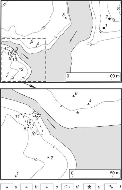
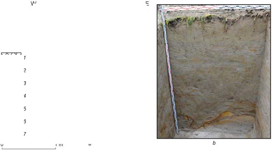
Fig. 4. Southern view ( b ) and stratigraphic section ( a ) of the northern wall at test pit 7.
1 – modern soil; 2 – aleurite; 3 – cryogenic deformations; 4 – sand; 5 – aleuropelite; 6 – paleontological material;
7 – number of the lithological layer.

bearing layer was found in situ under the bottom of the subaerial cover in the stratum represented by the interlayering of river alluvium and coastal slope deposits.
Below is a detailed description of the stratigraphy of the most expressive of the established sections.
Test pit 7 . The 2nd floodplain terrace. The edge of the test pit is 7.4 m above the edge of the towpath of the Kushevat channel. The dimensions of the pit are 2.0 × 1.0 × 2.4 m. The following layers have been uncovered at the pit northern wall (Fig. 4).
Layer 1. Modern forest soil. Thickness 0.1 m.
Layer 2. Pale-brown, parallel-thin-bedded silt (small layers are 1–3 mm thick). The bedding is wavy deformed by solifluction, slightly inclined towards the tributary of the Kushevat channel. The subaerial cover is predominantly deluvial. Thickness 0.3 m.
Layer 3. Fine parallel subhorizontal interbedding of gray silt and ferruginous reddish silt sand. Stratification deformations by solifluctional processes are noted. The subaerial cover is predominantly deluvial and deformed by solifluction. Thickness 1.1–1.6 m.
Layer 4. Light gray with rusty spots and interlayers, well-washed medium-grained sand with gravel and small pebbles, dented and crushed by solifluction. Interlayers of gray silty sand. The alluvium is solifluctionally deformed and is subjected to sliding down the slope. The layer is curved, with base amplitude of up to 0.35 m. Average thickness 0.3 m. Paleontological material is recorded in the layer.
Layer 5. Parallel-subhorizontal-layered light gray sand, fine- to medium-grained, well-washed. Paleo-Ob alluvium. The top is subjected to solifluctional deformations. Visible thickness 0.6 m.
Characteristics of paleontological material
The total amount of faunal material from Kushevat is 31 specimens, of which 28 were found in a stratified context. The majority of the items were collected from test pits 7, 10, and 12 (see Fig. 3). In test pit 7, twelve bones were found (see Fig. 4, 5): a fragment of antler, the metacarpal and tibia of a reindeer ( Rangifer taradus ), five small fragments of tubular bones from a mammoth ( Mammuthus primigenius ), a fragment of the mandible of a bison ( Bison priscus ), and three unidentifiable fragments; in pit 10, there were two fragments of antler and two fragments of the base of the antler rod of a reindeer, a fragment of a rib of a bison or musk ox ( Bison priscus / Ovibos moschatus ), and an unidentifiable fragment; pit 12 contained six fragments of tubular mammoth bones, two fragments of a reindeer antler, and two unidentifiable fragments. The deposits containing these faunal remains have a common genesis and composition, and belong to the same geological unit. A fragment of a bison rib, the first phalanx of an elk ( Alces alces ), and a humerus of a red deer ( Cervus elaphus sibiricus ) were also collected on the coastal shallow close to pit 3. In general, the
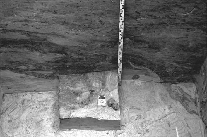
Fig. 5. The occurrence conditions of paleontological material in layer 4 of pit 7.
faunal assemblage of this locality demonstrates low species diversity; the main species are reindeer and mammoth. At the same time, the features of the reindeer remains suggest that their origin may be associated with hunting activities.
At present, the results of radiocarbon dating of faunal remains from the Kushevat locality have not yet been obtained. However, the analysis of the available data on the study area makes it possible to determine accurately and reliably the possible chronological framework of accumulation of the bone-bearing layer at the site. In this area, one of the best-studied sections of the Neopleistocene deposits and the closest to Kushevat (2 km to the west) is the Gorki section (see Fig. 2). Here, in a thin layer of lacustrine-boggy sediments, overlain by a subaerial cover 9.3 m thick, a fragment of a reindeer antler was found, which gave a calibrated AMS-date (RICH-27980.1.1) of 40,240 to 37,530 BP. The subaerial deposits unearthed in Kushevat and the Gorki promontory are chronologically close to loess-like loams in the section near the village of Lopkhari (5 km southeast of Gorki), described in detail earlier (Zolnikov et al., 2018). This is the section of the coastal cliff at the southern border of the village, where two trenches were made at the base of the subaerial cover and three peaty paleosols, underlying the alluvial deposits, were exposed (see Fig. 2). For the Lopkhari-1 lower paleosol layer, three 14C dates in the range of cal 51–45 ka BP were generated at two laboratories (see Table). Thus, cross-dating shows that alluvial sedimentation was replaced by subaerial at the second floodplain terrace in the range of ~50–45 ka BP. The middle paleosol identified in both sections was dated in the same laboratories to cal ~43–40 ka BP, and the Lopkhari-2 upper paleosol layer was dated in the range of cal ~37–36 ka BP (see Table). The upper paleosol interlayer was exposed in the subaerial loess-like sandy loams in the test pit 2 km located northwards from the village of Lopkhari and dated to cal ~38–35 ka BP (see Table).
Currently, twelve dates in the range of cal ~51– 35 ka BP are available for the lower part of the subaerial cover in the Gorki–Kushevat–Lopkhari area. Three dates in the range of cal 51–45 ka BP were obtained on the samples directly from the hydromorphic paleosol interlaying the alluvium and the subaerial cover. The available geological and geomorphological data indicate that the bone-bearing layer at Kushevat is confined exactly to this stratigraphic level.
Evidence of ancient human habitation at the Kushevat site
In the course of studying the paleontological material recovered from pits 7, 10, and 12, an item presumably with traces of anthropological effect was identified. Its
Radiocarbon dates of the Neopleistocene materials from the sections near the village of Lopkhari
|
Paleosol |
14С-date, BP |
Calibrated date, BP |
Code |
|
Lopkhari-1 |
|||
|
Lower |
41,530 ± 1280 |
47,167–42,680 |
LU-9875 |
|
49,550 ± 620 |
≥ 51,148 |
GV-02019 |
|
|
42,300 ± 382 |
45,622–44,426 |
GV-02480 |
|
|
Middle |
38,640 ± 1160 |
44,523–41,375 |
LU-9876 |
|
35,170 ± 296 |
40,955–39,695 |
GV-02479 |
|
|
Lopkhari-2 |
|||
|
Middle |
36,060 ± 1110 |
42,511–39,261 |
LU-9878 |
|
43,300 ± 386 |
46,500–35,605 |
GV-02482 |
|
|
Upper |
32,520 ± 470 |
38,771–36,037 |
LU-9877 |
|
31,910 ± 288 |
36,922–35,605 |
GV-02481 |
|
|
Test pit 2 |
|||
|
Upper (?) |
30,940 ± 370 |
36,102–34,609 |
LU-9874 |
|
33,290 ± 283 |
39,103–37,143 |
GV-02478 |
|
further analysis was carried out in the Paleotechnology Laboratory of the Scientific and Educational Center “New Archaeology” at the Novosibirsk State University. The osteological material was examined using an Olympus SZ2-ET stereoscopic microscope (maximum magnification ×56).
A fragment of a reindeer antler (pit 12) shows a small series of rather deep linear marks, which are clearly visible with the naked eye; and one less noticeable, slightly curved, superficial thin line (Fig. 6), most likely associated with the same processes as those that caused the formation of the series of marks. All scratches are quite long, without any deviations or additional thinner side marks. It can be inferred that each scratch was made by one translational motion of the tool along the antler (cutting). The deeper straight lines were formed through the stronger pressure on the implement. Considering the features of the marks and the fact that the antler was found in situ , the noted scratches cannot be associated with natural processes.
A small, irregularly retouched flake of yellowish-brown flint can be considered indirect evidence of the presence of ancient humans at Kushevat. The artifact was found on the riverbank near test pit 4, in the eroded accumulation of sediments similar in composition to the bone-bearing layer of the site. The connection of the flake with this particular lithological unit is not obvious, but quite probable.
Discussion
Intense archaeological research carried out in the Far North in the last two decades has significantly changed the scientific conceptions of the processes of the early peopling of this region, unfavorable for permanent residence. At present, numerous facts indicate that the first attempts to populate the northern territories, with their harsh climate but rich and diverse biological resources, occurred at
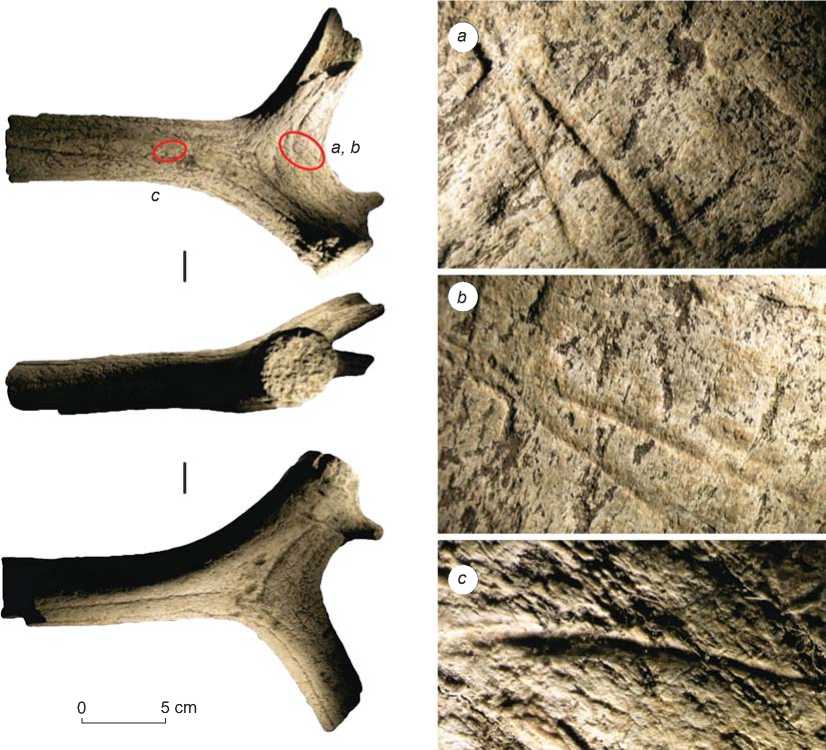
Fig. 6. A fragment of a reindeer antler with traces of anthropological effect.
very early stages of human history. Leaving aside the discussion about the chronology and cultural interpretation of materials from the Diring Yuriakh site in Central Yakutia, which were considered by various researchers in a very wide time frame from the late Early to the terminal Late Neopleistocene (Mochanov, 1992: 68–74; Ranov, Tseitlin, 1991; Derevianko, 2017: 78–84; Kuzmin, 2000), it can be argued that the first paleo-groups penetrated into the circumpolar zone no later than the initial stages of the Upper Paleolithic, ~40–35 ka BP (Pitulko, 2016). Northward migrations during this period have been recorded in different regions of Eurasia, from the northeast of Eastern Europe to Eastern Siberia (Pavlov, 2015; Pitulko, 2016; Pitulko et al., 2016). The most complete picture of the adaptation strategies and basic economic activities that made this process not only possible, but also successful, is given by the materials from the Yana site (northwestern Yakutia) (Pitulko, Pavlova, 2010: 175–196; Pitulko, 2012). Owing to the natural conditions, the unique set of artifacts has been preserved in full. The toolkit showed the importance of bone in the subsistence strategy of ancient people, the proportion of items made of bone, antler, and ivory in the kit, and how dependent people were on the availability and quantity of these materials, often associated with natural areas of accumulation of faunal remains—the so called mammoth graveyards (Derevianko et al., 2003: 120–126; Zenin et al., 2006; Makarov, Rezvy, 2009; Pitulko, Basilyan, Pavlova, 2011; Pitulko, 2016; Makarov, Rezvy, Gorelik, 2018).
The importance of such types of organic raw materials for the subsistence strategy of ancient humans can be traced not only in the regions of the Far North, where almost all the identified sites are associated either with “mammoth graveyards” or with the disposal of bone remains from solitary representatives of large fauna (Pitulko, 2016), but also in more southern regions, primarily where there is a certain deficit of other natural resources—stone and timber. This situation is most typical for the West Siberian Plain, including the middle and lower reaches of the Ob (Abramova, Matyushchenko, 1973; Makarov, Rezvy, 2009; Zenin, Leshchinskiy, 2017). This region is extremely poor in the Paleolithic sites, the bulk of which are concentrated in its western (foothills of the Urals) and eastern (foothills of the Altai-Sayan Highland) outskirts. The sites located near the Ob riverbed or in the lower reaches of its main tributaries are usually located in the immediate vicinity of the “mammoth graveyards”, and reveal a rather small number of stone tools; however, their collections also contain very few items made from organic raw materials, which can be considered a result of the poor preservation of bone remains in general. At the same time, even the random finds collected from erosion areas in zones of natural accumulation of the Pleistocene fauna show traces of the use of bones by humans (Volkov, Vasiliev, 2017).
The dependence of ancient humans on the sources of organic raw materials should also have taken place in those regions of the Lower Ob where the research was carried out, since this area is extremely poor in lithic raw material suitable for continuous knapping. The main source of such material for the ancient population could have been the alluvium of the western tributaries of the Ob, flowing from the Ural Mountains and carrying flint pebbles, silicified and hornfelsed sedimentary rocks, quartzites, effusive rocks, etc. However, the long distance of transportation and the significant thickness of coastal sandy sediments, which complicate the search for the pebble material, do not make this source common and accessible. Another component of the local raw material is blocks, boulders, and pebbles from eroded deposits of ancient moraines; but they include quite few rocks suitable for continuous knapping; these are mainly shale, granite, quartz, and coarse weakly silicified sandstones. Thus, in the area under study, in the Late Neopleistocene, there were no easily accessible and abundant reserves of high-quality raw materials. This suggests the focus of the local paleo-groups on the material supplied primarily from the eastern foothills of the Urals; economical use of stone resources; absence of workshops or sites with a large number of lithic artifacts; and widespread use of alternative materials, primarily bone, antler, and ivory.
From the early stages of the Russian colonization of the Lower Ob basin and up to the present day, a large number of bone remains of representatives of the mammoth faunal complex have been found both on the Ob towpath (owing to seasonal erosion of the bedrock coast) and in a stratified context, although much less frequently. During field studies in 2016–2019, a representative collection (more than 100 specimens) of identifiable bone remains of Pleistocene fauna was collected on riverbanks in the lower reaches of the Ob, some of which were dated using the accelerator mass-spectrometer of the Budker Institute of Nuclear Physics of SB RAS. Dates ranging from cal 50 to 15 ka BP were generated on 19 samples of mammoth bones, and 2/3 of them are in the range of cal 30–20 ka BP. The next most representative category was bone remains from the woolly rhinoceros (Coelodonta antiquitatis): six dates form two groups of cal 43–38 and 27– 25 ka BP. The bones of reindeer and horse (Equus ferus) are represented in the same quantity (four samples each). The obtained dates are distributed fairly evenly in the same interval of cal 40–10 ka BP. Bison bone remains are more chronologically concentrated: all three samples showed a range of cal 50–40 ka BP. Two dates obtained from the bones of musk ox fall in the period of cal 41–32 ka BP. These data substantially supplement the list of dates generated on the surface faunal materials collected near Gorki: mammoth – 26,390 ± 250 BP, average calibrated value 30.6 ka BP; woolly rhinoceros – 28,750 ± 300 BP, average cal value 33.0 ka BP; bison – 32,550 ± 400 BP, average cal value 37.3 ka BP; wolf (Canis lupus) – >45 ka BP (Pitulko, 2016).
Thus, the dating of the Upper Pleistocene faunal materials from the Lower Ob region and their analysis make it possible to assert that during the second half of the Late Neopleistocene, the species composition of the megafauna did not actually change in this region. Consequently, an ancient man, being a consumer of bio-resources of the mammoth faunal complex, during all this time could live in familiar conditions and be guaranteed to meet animals of certain hunting species and areas of concentration of bone material of natural origin. The Kushevat site, discovered during the reconnaissance works of 2019–2020, is obviously associated with such a bone concentration area. The discovery of traces of anthropogenic activity on a fragment of the reindeer antler makes this site unique. The age of the bone-bearing layer of 35–50 thousand years assumed on the basis of a set of scientific data and the available 14C- and AMS-dates from the nearby stratigraphic sections, makes Kushevat the most ancient and northernmost Paleolithic site known in the region at present.
Taking into account the available information about the early peopling of the northern regions of Yakutia, the mouth of the Yenisei, and the lower reaches of the Pechora, the discovery of the evidence of a contemporaneous human presence in the Lower Ob region does not seem extraordinary; on the contrary, it looks quite logical and expected. The fact that it is associated exclusively with traces of anthropological effect on the bones of game animals is also fully consistent with the natural conditions, in which the first colonists of these territories lived. First of all, this is a shortage of stone raw materials, which determines their limited use and, as a consequence, the rare occurrence of lithic artifacts. At the same time, solitary cores, spalls, and tools from a presumably Paleolithic age have been recorded among the collected surface materials from the towpath along the entire length of the Lower Ob, including the Gulf of Ob (Zolnikov et al., 2019).
Conclusions
Over the past 20 years, our ideas about the peopling of the northern regions of Eurasia have undergone significant changes. According to published data, the early colonization of the polar regions, which took place in several stages, began at the turn of the Upper Paleolithic (45–40 ka BP), and possibly earlier, and ended in the first half of the Holocene (11–6 ka BP) (Besprozvanny, Kosintsev, Pogodin, 2014; Velichko et al., 2014; Pitulko, 2016). Traces of the pioneering development of northern Eurasia were recorded on many large rivers of the Arctic Ocean basin (Pechora, Yenisei, Yana, Kolyma). The Lower Ob region remained a “blank spot” in this respect. The northernmost evidence of human presence in this region was found at the Komudvany site, dating to the Pleistocene-Holocene boundary and located ~350 km south of the Arctic Circle. The research results of 2019–2020 made it possible to push back the date of the first appearance of man in the circumpolar regions of the western part of the West Siberian Plain, and to shift the border of its peopling 200 km to the north. The Ob, therefore, has become one of the last major Siberian rivers where traces of the Early Upper Paleolithic culture have been found in the northern latitudes. At present, the issue of the early peopling of the Lower Ob basin is far from solved, because the studies at Kushevat are at their initial stage, and the archaeological evidence is present here only in the form of traces on the animal bones. At the same time, the discovery of a stratified Paleolithic complex in this region is itself a significant event for Paleolithic studies both in the region and in northern Asia as a whole. The large area of distribution of faunal remains at the site, along with the presence of lithic artifacts among the surface finds, suggest the great potential of Kushevat for further study of the early stages of the history of the circumpolar regions of Siberia, as well as hope for the discovery of new stratified Stone Age sites here.
Acknowledgements
This study was supported by the Russian Science Foundation, Project No. 19-78-20002. The authors are grateful to S.K. Vasiliev for consultations on the species identification of paleontological material from Kushevat; and to the heads and employees of the AMS-laboratory of the Royal Institute for Cultural Heritage (Brussels, Belgium), the Laboratory of Geomorphological and Paleogeographic Studies of the Polar Regions and the World Ocean (St. Petersburg State University), and the Center of Geochronology of Cenozoic (Novosibirsk), who carried out the dating of organic materials.
