Новая модель строения земной коры по результатам электромагнитных зондирований с контролируемыми источниками

Автор: Жамалетдинов Абдулхай Азымович
Журнал: Вестник Мурманского государственного технического университета @vestnik-mstu
Статья в выпуске: 2 т.15, 2012 года.
Бесплатный доступ
Предлагается разделить земную кору на две части – верхняя, хрупкая кора (собственно геологическая) и нижняя кора, квазипластичная, физическая. Верхняя кора мощностью 10-15 км принимает самое активное участие в геологических процессах. Ее главные особенности – резкая горизонтальная неоднородность, широкий диапазон изменения удельного электрического сопротивления горных пород (от 1 до 105 Ом·м), высокая пористость, хрупкость и наличие флюидов, которые дренируют земную толщу от дневной поверхности до глубины 5-10 км. Нижняя кора (в интервале глубин от 10-15 до 35-45 км) отличается высоким удельным электрическим сопротивлением (105-106 Ом·м), горизонтальной однородностью электрических свойств, низкой пористостью и повышенной пластичностью. Электрическая проводимость нижней коры, наряду с геологическим составом, во многом определяется влиянием планетарных физико-химических параметров (давление, температура, вязкость), фазовыми переходами вещества, и геодинамическими особенностями эволюции различных сегментов Земли. Учитывая отмеченные свойства, нижнюю кору следует отнести к верхней мантии, ограничив понятием геологической земной коры лишь верхние 10-15 км мощности литосферы.
Земная кора, электромагнитные зондирования, контролируемые источники, дилатантно-диффузионная проводимость, геодинамическая интерпретация
Короткий адрес: https://sciup.org/14294475
IDR: 14294475
A new model of the earth crust structure from results of the control source electromagnetic soundings
It is suggested to subdivide the Earth's crust into two parts – upper, brittle crust (namely geological) and lower, ductile crust (namely physical). The upper crust of 10-15 km thickness is the most actively involved in geological processes. Its principal peculiarities are: the sharp horizontal heterogeneity of electrical properties, a wide range of variations of specific electrical resistivity from 1 to 105 Ohm·m, a high porosity, brittleness, and a presence of fluids that drain the supra structure from the day surface owing to penetrate of meteoric waters to the depths up to 5-10 km. The lower crust (physical) belongs to the depth interval from 10-15 to 35-45 km (up to the Moho boundary). It is remarkable by the horizontal homogeneity of electrical properties and high specific electrical resistivity in the range of 105-106 Ohm·m, by the low porosity and increased ductility. Electrical conductivity of the lower crust is mostly determined by the influence of planetary physical-chemical parameters (pressure, temperature, viscosity), phase transitions of substances and geodynamic peculiarities of evolution for different segments of the Earth crust. As an area of physical processes influence, the low crust is nearer by its origin to the Upper mantle then to the geological Upper Earth crust.
Текст научной статьи Новая модель строения земной коры по результатам электромагнитных зондирований с контролируемыми источниками
-
1. Introduction
-
2. Block structure of the Earth crust electrical conductivity
The first doubts concerning a stretch of layered blocky division of geological structures to the depth of 35-45 km down to the Moho discontinuity have appeared during deep sounding with the Khibiny impact magnetohydrodynamic (MHD) generator ( Velikhov et al. , 1986; Zhamaletdinov , 1990). Sounding was carried out in the territories of the Karelia-Kola region and North Finland. As a result, about 10 blocks of the Earth's crust have been found, differing from each other by integral longitudinal conductivity S = h / ρ (where h – the thickness and ρ – apparent resistivity of the Earth crust) by more than four orders, from tenths parts to several thousand Siemences ( Zhamaletdinov , 2012). The vertical thickness of blocks h is estimated at 10 km. They cover area of up to tens of thousands of square kilometers. Blocks with a weak conductivity (0.1-1 S) are distinctive for the significant horizontal homogeneity. They are considered as the so-called "windows of transparency" favorable for carrying out the deep and super deep soundings of the lithosphere. Blocks of a higher and high conductivity are sharply heterogeneous and produce distortion on results of the deep soundings.
-
3. Transversal resistance of the Earth crust
The second by importance result of the deep soundings, that has a direct relationship to our topic, is the conclusion about the high resistance of the middle part of the lithosphere in the depth interval from 10-15 to 40-50 km. The value of integral transversal resistance T was 1010 Ohm∙m2, where T = h ∙ ρ ( h – is the total thickness of the lithosphere and ρ – the specific resistivity of rocks). These estimates have been obtained on the Fennoscandian shield while "Khibiny" and "FENICS" experiments ( Zhamaletdinov , 1990; Zhamaletdinov et al ., 2011). This conclusion has followed directly from the fact that there are no intermediate conductive layers and associated free fluids in the lithosphere in that depth interval ( Zhamaletdinov , 1990).
-
4. Conductive channels in the Earth crust
The third by importance experimental result, also directly concerned to the matter of the present work, is the discovery of subhorizontal conducting channels in the upper part of the Earth's crust ( Zhamaletdinov , 2012). The phenomenon has been discovered firstly while performing the MHD-experiment "Khibiny" ( Zhamaletdinov , 1990). By division of the field generated by the Khibiny MHD source into galvanic and inductive components, it has been found that a low frequency galvanic current propagates on hundreds of kilometers in the upper ~10 km layer of the Earth's crust ( Zhamaletdinov et al ., 1995). Galvanic current concentrates in narrow stretched sulfide and carbon bearing structures and causes the effects of 2D conductive channels. The depth extent of conducting channels does not exceed 10 km by different ways of the data interpretation ( Zhamaletdinov et al ., 1995; Zhdanov, Frenkel , 1983). It is important to emphasize that the current strength estimated by circulation of the magnetic field varies slightly along the directions of the conducting channels. The current in them does not penetrate deeper than 10-15 km due to the high resistance of the isolating basement.
-
5. Protobasement hypothesis
To interpret the described experimental data, the author suggested a hypothesis about the existence of an ancient weakly conductive protobasement at a depth of about 10-15 km ( Zhamaletdinov , 1990). It was supposed following J. Sederholm that a heterogeneous more conductive supracrustal cover is formed on the homogeneous surface of the protobasement. Its appearance was the result of long processes of deposition and redeposition of effusive sedimentary rocks, intrusion of magmatic bodies, and common metamorphism. In other words, a geologically active medium (supra structure), heterogeneous in its electric properties and generally more conductive, was formed on the surface of the homogeneous, high resistive protobasement. The primary role in the origin of the super crust was played by external factors – in addition to the geological processes – first of all, the appearance of the atmosphere, hydrosphere, and life (i.e., biosphere, in the terminology of V.I. Vernadsky). In addition to this, the influence of factors from space – meteorite bombardments and lunar-solar tidal disturbances, whose amplitude could reach 100 m near the Roche limit – should not be excluded.
-
7. Electrical conductivity of dilatancy-diffusion nature in the Earth crust
A visible role in investigation of electric conductivity of the crust within the Baltic Shield was played by frequency soundings with the use of a moderate power automobile generator 29 kW ( Shevtsov , 2001; Zhamaletdinov et al ., 2002). Soundings were carried out in the Kola Peninsula, Karelia, and Finland. Spacing reached 50-100 km, and the frequency range was 1-1000 Hz. The most interesting result was discovery of an intermediate domain of lowered resistance in the depth range from 2 to 10 km. The nature of resistance lowering is attributed to penetration of meteorite (surface) waters to the corresponding depths along the so-called listric faults and cracking zones that become more gentle with depth. This kind of objects was described for the first time on the basis of geological suppositions ( Goryainov, Davidenko , 1979). According to the model by V.N. Nikolaevsky (1996), existence of free fluids at the depths of 10-15 km can be explained by dilatancy, which is determined as an irreversible increase in volume of polycrystalline aggregates when shifting. Shifting processes appear in the lithosphere as a result of a rapid increase in the horizontal (tangential) component of rock pressure with depth compared to that of the vertical (lithostatic) component. The layer possesses an insignificant (1-2 Siemences) longitudinal conductivity and related manifestation of dilatant-diffusion processes in the base of the uppermost brittle layer of the lithosphere. It is designated as the "DD layer" ( Zhamaletdinov et al ., 2004).
-
8. Isotropic, horizontally homogeneous structure of the Low crust and Upper mantle electrical conductivity
The results presented above, including the experiments with the powerful Very Low Frequency (VLF) emitting antenna "Zevs" ( Velikhov et al ., 1994), were still insufficient to obtain a complete view of the lithosphere structure by geoelectric survey data, despite the great volume of the works made. The "trouble spot" of all the deep sounding experiments with powerful controlled sources both in Russia and abroad was the use of one polarization of the primary field. This did not enable us to estimate the possible influence of regional anisotropy and horizontal heterogeneity of the medium on the observation results. The mentioned difficulties were overcome by carrying out the international experiments FENICS-2007 and FENICS-2009 ( Zhamaletdinov et al ., 2011). Soundings of FENICS experiment were carried out at spacings up to 700 km between transmitter and receiver in the frequency range of 0.1-200 Hz with the use of two mutually orthogonal grounded electric lines (industrial power lines) of 109 and 120 km length.
The structure and volume of the Earth's crust are accepted to be linked to the position of the Moho seismic discontinuity, which was found based on stepwise growth of velocities from 7.5 to 8.0 km/s on average for longitudinal waves and from 4 to 4.5 km/s on average for transversal waves. Within continents, the Moho discontinuity is traced continuously in the relatively narrow range of depths (35-45 km) with rare sinks mostly beneath mountain ridges (down to 55-75 km). Numerous results of complex investigations show that the position of the Moho discontinuity is almost not related to the character of geological structures and only slightly reflects the relief of the day surface. Nevertheless, a certain geological meaning is attributed to it. The thickness of the Earth's crust and the transition boundary from the Earth's crust to the upper mantle are usually attributed to it. In the present paper, an attempt is made to present the structure of the continental crust in a more precise manner based on the results of deep electromagnetic sounding with the use of powerful controlled sources.
The nature of conductive blocks (crustal anomalies) is related to the presence of sulfide and carbon bearing substance of biogenic origin ( Semenov , 1970; Adam , 1974; Zhamaletdinov , 1990). They are conventionally identified as the "SC-layer" of Semenov ( Zhamaletdinov , 2005). A scheme demonstrating distribution of crustal anomalies of electronic conductivity within the eastern part of the Baltic Shield and within Russian territory was made in ( Zhamaletdinov , 2012).
industrial power lines of 800 kV "Volgograd–Donbass" of 470 km length ( Zhamaletdinov et al ., 1982; Velikhov et al ., 1986). The main result of these works, except for the practical ones, was the conclusion, same as for the Fennoscandian Shield. Penetration of the galvanic (DC) current to depths more than 10-15 km in the territory of the East European Craton is restricted by the presence of an isolating basement, that was attributed to the presence of ancient high resistive protobasement. Despite the great distance between the source and receiver (up to 650 km), the curve of apparent resistivity of the deep sounding at a constant (pulse) current did not leave the limits of S-asymptotics signifying the absence of the effect of galvanic current penetrating into depths. The value of the lateral resistance of the lithosphere within the East Russian plate to its whole thickness is 4∙109 Ohm∙m by the lower limit, which is close to the estimate obtained for the Baltic Shield. The electric conductivity anomalies found in the Earth crust of the East European Craton (Vorontsovskaya, Frolovskaya, Donbass) are of a cover character and occupy the upper part of crystalline basement at the depth range from the roof till 10-15 km.
The main result of the "FENICS" experiments is the conclusion about the high resistance and 1D character of the deep section of the lithosphere with the high degree of subhorizontal stratification in the depth range from 15-20 to 50-70 km in the territories of Kola-Karelian region and Northern Finland. The curves of apparent resistivity at two different polarizations of the primary field (North-South and East-West) nearly coincided with each other both by impedance and by component processing within the limits of the wave (far field) zone action.
penetrate into depths along the cracks and faults becoming gentle with depth. As it was mentioned above, this layer has a dilatancy-diffusion nature and is identified as the "DD layer". Deeper than 10 km, the specific electrical resistivity of rocks increases again up to 105-106 Ohm·m. Thickness of the high resistive part of the lithosphere is estimated at 60-80 km. The average value of the crosscut resistance is about 1010 Ohm·m2. Below, an exponential decrease in resistance occurs under the influence of temperature increase with depth. At the depth range of 200-300 km resistivity fell down to 100 Ohm·m, pointing out on the possible existence of the asthenosphere.
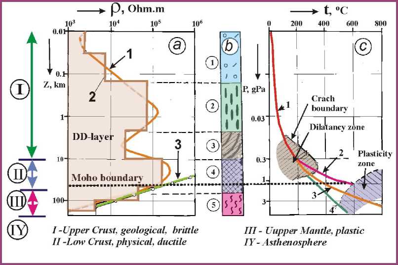
Fig. Electrical section of the lithosphere for the Eastern part of the Baltic Shield and its geodynamical interpretation.
-
а – electrical section from inversion of the control source sounding results; 1 – smoothed section;
-
2 – layered section; 3 – electrical section upon the laboratory research of dry rock samples at high temperature ( Cermak, Lastovickova , 1987).
b – geodynamical column upon electrical section ( a ). Layers numbered in circles: 1 – water-saturated moraine and crystalline basement; 2 – upper, brittle crust with subvertical faults; 3 – upper, brittle crust with flattening (listric) faults; 4 – low, ductile crust (pseudo plastic);
-
5 – the plastic lithosphere.
10. Conclusion
c – phase diagram of dilatancy and plasticity zones after Nikolaevsky V.N. (1996) with temperature curves: 1 – measured temperature curve in the Kola Superdeep Hole SG-3, 2 – its extrapolation to the depth after ( Kremenetsky et al ., 1998); 3 – same after ( Zhamaletdinov , 1990); 4 – same after ( Valle , 1951).
The summarized analysis of the presented above results of electromagnetic soundings, made with the use of powerful controlled sources, has allowed us to divide the Earth's crust, traditionally seen by seismic data to the Moho depth, into two parts, namely, upper and lower. The upper one is more conductive and is the most actively involved in geological processes. Its principal peculiarities are the sharp horizontal heterogeneity and a broad range of specific electrical resistivity variations of rocks (from 1 to 105 Ohm∙m), the contrasting character of the structure of geologic units, a common distribution of fault structures, higher brittleness, the presence of fluids that drain the suprastructure from the day surface owing to supply of meteor waters to depth (DD layer), and common distribution of electronic conducting units ("SC layer" of Semenov) in the composition of volcanogenic-sedimentary sequences. The lower crust (depth interval from 10-15 to 35-45 km) is distinctive for the high specific electric resistivity (105-106 Ohm·m) and horizontal homogeneity of electric properties, despite sharp changes in the composition of the overlying geological units. The rocks at these depths form a ductile zone; the porosity and content of free fluids in them reduces sharply. All these facts signify that the electric conductivity at depths of more than 10-15 km is determined mostly by the planetary physical-chemical parameters (pressure, temperature, viscosity), the phase transitions of the substance, and the geodynamic peculiarities of evolution of different segments of the Earth, rather than by the geological processes observed near the day surface.
Acknowledgments. The author is grateful to Academician N.P. Laverov for support and discussion of the work, and to N.N. Rzhevsky, director of the St. Petersburg Division of the Seabird Exploration FZ_MK company, on whose initiative this communication written, and for his useful remarks. This work was supported by the Russian Foundation for Basic Research (project nos. 10-05-98809_p-sever-a and 11-05-12033-ofi-m-2011) and by the Earth Sciences Division of the Russian Academy of Sciences (project no. 6 "Geodynamics and ways of lithosphere deformation").
