Novopetrovka III-an early neolithic site in the Western Amur basin and its chronology

Author: Derevianko A.P., Nesterov S.P., Tabarev A.V., Alkin S.V., Uchida K., Kunikita D., Morisaki K., Matsuzaki H.
Journal: Archaeology, Ethnology & Anthropology of Eurasia @journal-aeae-en
Section: Paleoenvironment, the stone age
Article in issue: 4 т.48, 2020.
Free access
This article discusses the chronology of Novopetrovka III—a Neolithic settlement in the Western Amur basin, evaluated by the radiocarbon analysis of charred remains on pottery. The Novopetrovka culture as a whole, represented by Novopetrovka I–III and Konstantinovka sites, which had been excavated in the early 1960s, was dated to the 5th (possibly 6th) to early 4th millennia BC on the basis of the typology of the blade industry. The overview of data on prismatic blades manufactured by the pressure technique demonstrated that blade industries appeared in a vast territory of Eurasia in the Final Pleistocene to Early Holocene and, in certain regions, survived until the Chalcolithic. Therefore, they are only a rough guide to the relative chronology of the sites. In the 1990s, after the appearance of radiocarbon dates generated from samples of organic remains in temper and charred remains on pottery from Novopetrovka II, the culture was redated to 15.5–10.8 cal BP. A comparative analysis of new radiocarbon dates based on charred remains on pottery suggests that the age of Novopetrovka III is 9.0–9.5 thousand years. Because no changes were traced in the Novopetrovka sites over a long period of time, the chronological assessment of the Novopetrovka culture in toto and of its separate sites is problematic.
Amur Region, Novopetrovka culture, Early Neolithic, AMS-dates, charred remains, pottery, chronology, Novopetrovka III
Short address: https://sciup.org/145146041
IDR: 145146041 | DOI: 10.17746/1563-0110.2020.48.4.057-066
Text of the article Novopetrovka III-an early neolithic site in the Western Amur basin and its chronology
Archaeological sites of the Early Neolithic Novopetrovka culture discovered in the vicinity of the village of Novopertovka, Konstantinovsky District, Amur Region, are located on the 8–9 m high Amur left-side terrace 1, on the left bank of the Dunayka River, 2–3 km from its confluence with the Amur. The wide Dunayka flood plain is a remnant of one of the Amur channels in the branched flow system that existed here in the Early Holocene (Nikolskaya, 1954) (Fig. 1). In the heavy rain of summer season, the water level of the Dunayka is high; during the Amur flood periods, the Dunayka is filled with the Amur water, whose level is as high as the terrace edge (Fig. 2).
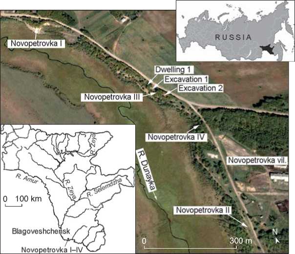
In the early 1960s, three settlement sites were excavated within an area of approximately 1 km on the Dunayka promontory coastline (Fig. 3). The site of Novopetrovka I (Krutoi Mys) yielded a dwelling partly destroyed by the modern road (in 1962). The site contained artifacts from the Novopetrovka culture; a test pit was established next to this site (in 1965)
(Derevianko, 1970: 14, 32–37). The Novopetrovka II site is located 1.16 km to the southeast of Novopetrovka I. The site contained eight dwellings, two utility buildings, and seven work areas of the Novopetrovka culture (1963, 1964) (Ibid.: 15, 37–109). In 1962, “several more dwellings” were excavated between the abovementioned sites, and another large dwelling was found in 1964 (Fig. 4). It was named Novopetrovka III (Ibid.: 13–14). The site was located approx. 620 m to the southeast of Novopetrovka I and 530 m to the northwest of Novopetrovka II. However, in 2003–2004, excavations over an area of 434 m2 have not revealed any other dwellings (Derevianko, Nesterov, Alkin et al., 2004: 102). However, approx. 340 m to the northwest of Novopetrovka II, a new site of this culture was found— Novopetrovka IV: a corner of some construction was traced in the test pit (Nesterov et al., 2008).
The characteristic feature of the Novopetrovka settlements located on the bank of the old channel of the Amur River (including the Konstantinovka site, located 20 km west of the sites, near the village
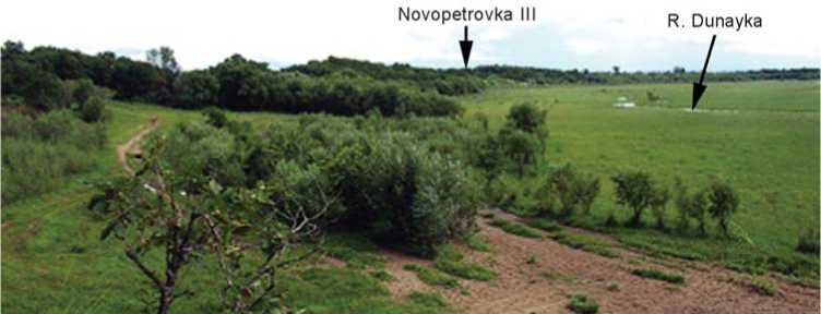
Fig. 1. View from the north, from Novopetrovka I on the Dunayka flood plain. Photo by S.P. Nesterov, 2003 .
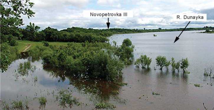
Fig. 2. Dunayka flood plain during the flood in 2003 (view from the north, from Novopetrovka I). Photo by S.P. Nesterov .
Fig. 3. Location of the sites near the Novopetrovka village.
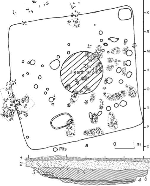
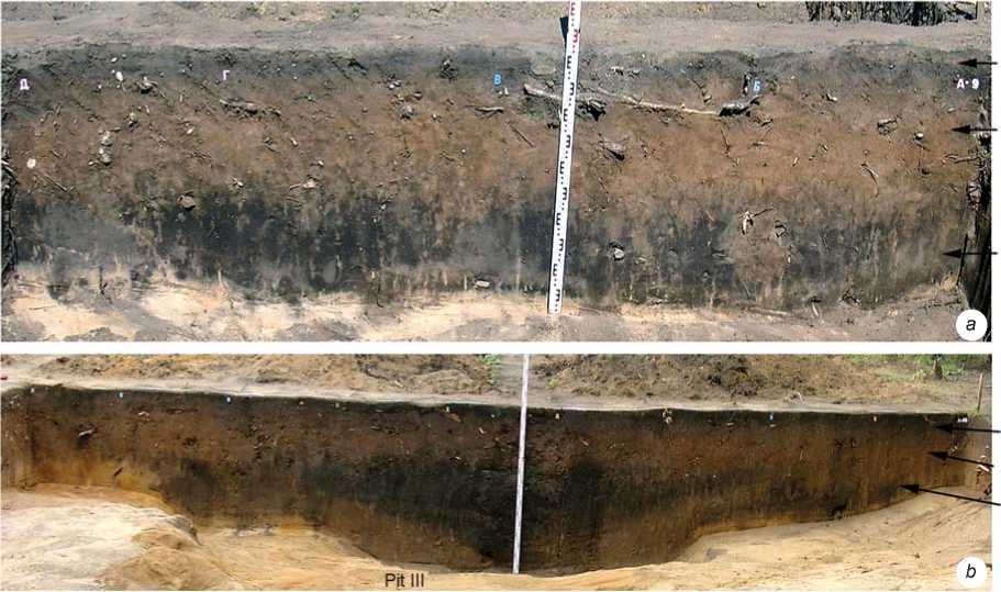
of Novopetrovka (Derevianko, 1970: 26–17)) is the absence of any depressions on the modern surface in places over the Neolithic dwellings, which is evidenced by their stratigraphic columns (Fig. 4, b ). Studies carried out on the terrace over an area of ca 95 m long and up to 20– 28 m wide, 18 m south of dwelling 1 at Novopetrovka III, have shown that the stratigraphy is basically the same in the southern portion of the terrace and in its northern part close to the mentioned dwelling. The established stratigraphic sequence was similar to the sequence of lithological layers at other Novopetrovka sites. Analysis of stratigraphic sections of the walls and baulks of the excavations provided the generalized scheme of deposits in the given area of the terrace (Fig. 5).
Layer 1 . Modern sod from 10 to 20–28 cm thick. This layer can be conventionally subdivided into two horizons, both by color and density. The roof of the layer is dense and black, while the bottom is loose and gets lighter in color. The boundary between layers 1 and 2 is uneven; in several places, frost clefts were noted.
Layer 2 . Loose, light brown loam*. The layer lies subhorizontally throughout the excavated area of the terrace. The thickness varies from 30 to 40 cm, and in some portions decreases to 10 cm. The layer yielded artifacts from the Novopetrovka culture. The isolated artifacts occur throughout the thickness, mainly in the bottom part, up to the boundary with layer 3.
9876 54 3?
j------------1------------।------------j------------1------------i------------।------------|_и
b
Fig. 4. Map ( a ) and stratigraphic section ( b ) of dwelling 1 (after (Derevianko, 1970: 110, 122)).
1 – sod; 2 – light-grayish-brown sandy loam; 3 – sand; 4 – black sandy loam; 5 – dark humic sandy loam.
Layer 1
Layer 2
Layer 3
Layer 1
Layer 2
Layer 3
Fig. 5. Stratigraphy of the site (2003). a – excavation 1; b – excavation 2.
Layer 3. Dark mixed sandy loam. The mixed structure is caused by numerous brown loam leaks and black humic spots. The layer consists of the buried soil 12–40 cm (20 cm on average) thick; its upper border is blurred both in color and linearly; the lower border is uneven, with numerous depressions into the underlying layer 4 containing alluvial sand. In these depressions, the layer’s color becomes black and more homogeneous. Judging by the planigraphic and hypsometric data, in the old times there were pits and old channels, some of which were large, up to 1.6 m deep. Saturation of the filling of these pits with the Novopetrovka artifacts (cores, broken stone tools on blades, debitage, pottery fragments, thermally split pebbles, small calcified bones, charcoal pieces, etc.) suggests that during the settlement’s habitation they all were open (probably, in the deepest ones, water accumulated) and were used for household and industrial waste. Apart from the pit fillings, layer 3 does not contain any significant archaeological finds, except for those rarely found in the brown spots and leaks from layer 2. Probably, the Novopetrovka people started developing this area of the terrace from the top of layer 3, whose surface was quite uneven (Derevianko, Nesterov, Alkin et al., 2004: 97– 98). Possibly owing to this last-named circumstance, the people did not erect other dwellings here.
In total, the overall collection of artifacts from the excavations of 1964 and the early 2000s (in sum, 534 m2), and the artifacts collected from the terrace slope and defensive fighting positions of the 1940s, contains 11 thousand lithic artifacts and pottery fragments (Derevianko, 1970: 122; Nesterov, Bolotin, 2003; Derevianko, Nesterov, Alkin et al., 2004: 103). The finds’ concentration decreases from north to south, i.e. away from dwelling 1, suggesting that this area, which is currently about 2700 m2 (undoubtedly, it was larger in antiquity, which is supported by the finds under the disintegrating edge of the terrace and on the tilled field 20 m to the east of the excavations), was a long-term “camp” with one dwelling and adjacent habitation zone. Layer 2 at Novopetrovka III was found to contain lithic artifacts and pottery from the Novopetrovka culture exclusively. Isolated potsherds of the Uril, Talakan, and Mikhailovskoye cultures, as well as Troitsky group of the Mohe culture, point to the absence of any younger continuous cultural horizon of the Early Iron and medieval period at this terrace.
Blade industry as a technological phenomenon of the Final Pleistocene-Early Holocene
The lithic assemblage from Novopetrovka III was classified by typological features into eight groups of cores for production of knife-like blades, core blanks, four groups of arrowheads, massive points, two groups of knives and inserts for knives, six groups of end-scrapers, knife-like blades, burins (side, straight dihedral, and end- burins), three groups of borers, combination tools, adzes, and hoes, as well as items intended for production of stone tools (hammerstones, pressures, and grinding stones) (Derevianko, 1970: 124–154).
The collection obtained from excavations of 2003– 2004 is well correlated to the above classification by the most important parameters (Derevianko, Nesterov, Alkin et al., 2004: 98–101). Most cores were imported in the form of pre-tested blanks and knapped at the site. The cores at the initial stage of flaking include specimens with one or two flaking surfaces, with partial or complete preparation of platform through fine faceting (Fig. 6). Scars of laminar detachments and preparation of platforms suggest that pressure technique was predominantly used. As long as the artisan was able to keep the necessary angle (under 90°) between the flaking surface and the platform, the core seemed to have been fixed in a special clamp. As the core became exhausted and owing to various technical faults (fractures, chipping of the flaking arch, etc.), manual fixation was used, and flaking was executed by pressure and percussion with or without intermediate tools. The main target product was tri- and tetrahedral blade blanks from 3–5 to 12–15 cm long. The blades were modified into various tools (arrow and dart-heads, points, borers, burins, knives, end-scrapers, inserts, etc.) through multidirectional burin spall removals, as well as dorsal and ventral marginal retouch (Fig. 7).
In domestic archaeology, the first systematic description of knapping techniques and methods of production of prismatic blades in the Paleolithic, Prehistoric Egypt, and in the cultures of the Mesoamerican and North American Indians was given by S.A. Semenov (1957: 61–72). He formulated the very important features of the pressure technique: “The technique of detachment of prismatic blades is based on the use of a short impulse. Obviously, these blades cannot have been produced by the direct blow of a hammerstone, as some researchers believe. This inference is supported by the striking platform on the narrow face of such blades: it is very small, sometimes barely traceable. The signs of percussion on the core platforms are never visible by optical observation of their surfaces. But the thorough preparation of the platform prior to blade-flaking is obvious. The preparation primarily consists of reduction of protrusions on the platform’s margins, the so-called ‘platform fringe’ resulted from detachment of previous blades…” (Ibid.: 62).
Notably, experimental studies in the field of reduction techniques in foreign archaeology have been carried out since the 1940s. The authors proposed various devices for fixing cone-shaped cores and producing blades with the aid of a hammerstone or pressure tool (Barnes, 1947; Crabtree, 1968; Quintero, Wilke, 1995; Sheets, Muto, 1972; Sollberger, Patterson, 1976). Many researchers pointed to the effectiveness of the long pressure tool (lever) and imparting a considerable impulse to it (Inizan, Roche, Tixier, 1992: 64). Domestic specialists, in the 1980–1990s, also studied the advantages of the lever structure. A series of experiments led to the predominant opinion that large and standard blades could be produced
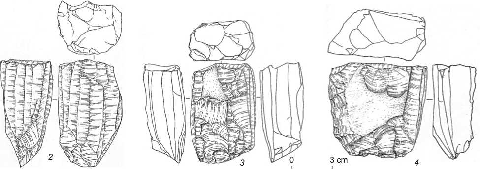
Fig. 6. Locations of cores in the cultural layer ( 1 ); trace-drawing of cores ( 2–4 ).
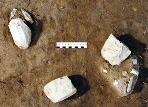
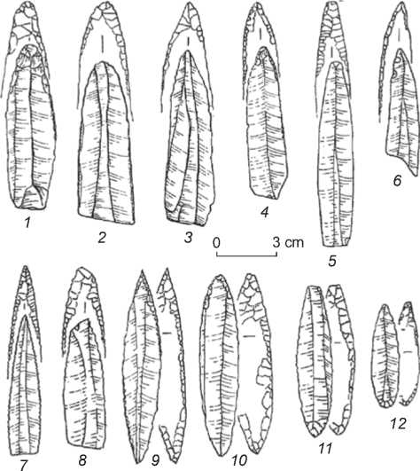
Fig. 7. Points on prismatic blades.
1–8 – with dorsal-ventral retouch on the distal end; 9–12 – with alternating dorsal-ventral retouch.
exclusively through “increased pressure” in the complex auxiliary structures (Volkov, Girya, 1990; Girya, Nekhoroshev, 1993).
During the last 15–20 years, interest in the technology of production of prismatic blades increased greatly, along with a significant increase in studies aimed at description, analysis, and replication of the techniques of particular lithic industries all over the world—in Western and Northern Europe, Near and Middle East, India, Central Asia (Gobi), Central and Mesoamerica (Pelegrin, 2002; Gladyshev, Tabarev, 2012; Borrell, Khalaily, 2016; Chabot, 2017; and others). Noteworthy is the collective monograph on the origins of pressure technique for production of micro- and macro-blades, providing the general picture of experiments with various raw materials (The Emergence…, 2012). With respect to the lithic industry of the Novopetrovka culture, these developments allow us to highlight two important points.
First, mass production of prismatic blades required comprehensive knowledge of raw materials, special devices and instruments, plus practical skills in core preparation and exploitation, along with a sufficient amount of raw materials in the form of blanks. Such stockpiles (hoards) of core blanks were found during excavations of the Novopetrovka sites (Derevianko, 1970: 42–43; Derevianko, Nesterov, Alkin et al., 2004: 51, 60) (see Fig. 6, 1 ). If all these ingredients were available, the skilled artisan could have produced several hundreds of high-quality blades.
Second, despite the external unwieldiness of the lever devices, their use did not affect the mobility of the ancient hunter-fisher-gatherers. This inference is supported, for example, by the analysis of bone and horn artifacts from rich collections of the Early Holocene sites in Northern Europe. The scholars have identified four tool categories (two types of pressure tools, striking tool, and lever-heads) that were used in blade production through pressure technique (David, Sorensen, 2016: 140). Experimental observations add this series to fragments of uneven-grained abraders and pieces of skin for shock absorption when fixing a core in the device. This “kit” has 1.5–2 kg weight on average and can be easily carried in a shoulder- or waist-bag.
Chronologically, blade industries based on the pressure technique of blade detachment emerged in the vast territory of Eurasia in the Final Pleistocene to Early Holocene, documenting the transition from the Paleolithic to Neolithic. However, in some regions, these survived until the Chalcolithic, demonstrating their effectiveness in the cultures of both appropriating and producing economies.
Chronology of the Novopetrovka culture and radiocarbon dates of the Novopetrovka III settlement
In the first monographic publication describing the Novopetrovka materials, the culture was dated to the 5th (possibly 6th) to early 4th millennia BC by its tool types and working techniques (radiocarbon dates were not available at that time) (Derevianko, 1970: 190–191). The first radiocarbon dates were generated for Novopetrovka II in the late 1990s to early 2000s. Three dates were obtained on the organic temper (grass) in the paste, one date on the charred remains on a potsherd (Table 1) (Derevianko, Kuzmin, Burr et al., 2004). The only place where a vessel with grass in the paste was found was dwelling 8. In its northern part, on the floor near the wall, pottery fragments lay “as a continuous mass in several layers. These were the remains of a single vessel made of poorly tempered clay with organic temper. The firing of the vessel was poor. The color of the fragments was light gray” (Derevianko, 1970: 98). Pottery from other dwellings (2, 3, 5–7) showed sand or rock-debris as temper*. Potsherds with rock debris in the paste were found in the filling of dwelling 8 (Ibid.: 94). The origin of the sample for which the radiocarbon date of 9740 ± 60 BP (AA-38109) was obtained has not been established (Kuzmin, 2006).
Table 1. Radiocarbon dates of the Novopetrovka sites in the Western Amur basin *
|
Site |
Material |
Radiocarbon age, BP |
Index |
Calibrated date (±2σ), BP |
|
Novopetrovka II ** |
Organic temper (grass) in ceramics |
10,400 ± 70 |
AA-20938 |
12,630–12,050 |
|
ʺ |
ʺ |
9765 ± 70 |
AA-20937 |
11,320–10,800 |
|
ʺ |
Charred remains |
9740 ± 60 |
AA-38109 |
11,260–10,810 |
|
Novopetrovka III |
Charcoal |
8040 ± 90 |
MTC-05943 |
9240–8610 |
|
Novopetrovka IV |
ʺ |
7890 ± 50 |
IAAA-32079 |
8980–8590 |
*After (Kuzmin, Nesterov, 2010).
**The date of 12,720 ± 130 BP (AA-38103, ±2σ 15,430–14,320 cal BP) obtained on the organic temper (grass) in the paste is not included, because in all publications this date is associated with the Gromatukha culture (Derevianko, Kuzmin, Burr et al., 2004; Derevianko A.P., Derevianko E.I., Nesterov et al., 2017).
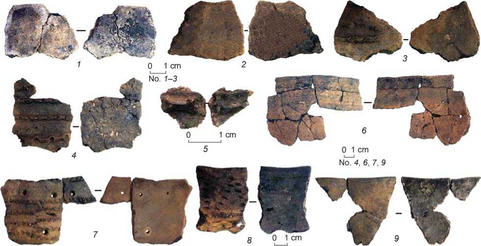
Fig. 8. Potsherds with charred remains on surfaces subjected to the radiocarbon dating (see Table 2).
For the site of Novopetrovka III, despite the availability of 16 charcoal pieces collected in 2003, only one radiocarbon date of 8040 ± 90 BP (MTC-05943), cal 9240–8610 BP (Table 1) was obtained (Kuzmin, Nesterov, 2010). In 2015, in the University of Tokyo, radiocarbon AMS-dating of ten samples of charred remains on Novopetrovka III pottery fragments (materials of 2003–2004) was carried out (Fig. 8, Table 2).
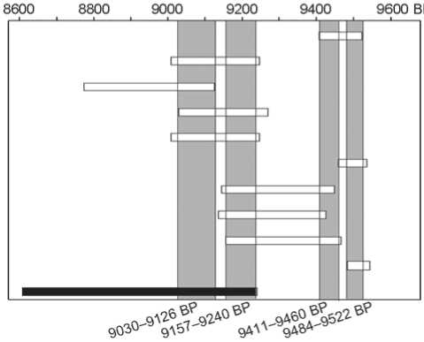
Synchronization of the calibrated dates obtained from charred remains on pottery and one date on charcoal produced two chronological ranges: the early period of 9522–9411 BP (8425 ± 30 BP, 8485 ± 35, 8535 ± 35 BP) and late period of 9030–9249 BP (8155 ± 35 BP, 8085 ± 35, 8200 ± 35, 8155 ± 35 BP; the charcoal date is 8040 ± 90 BP) (Fig. 9). The minimal gap between the end of the early period (9411 BP) and the start of the late period (9249 BP) is ca 170 years. Each interval, in its turn, consists of two periods, with a minor differences between them: 24 and 31 years. However, the limits of the three calibrated dates of the two charred potsherds (8315 ± 35 BP, 8290 ± 35 BP, and 8335 ± 40 BP) fall within both early and late chronological group. Thus, these dates can be attributed to either the early, or the late, or even the intermediate group. The first two dates were obtained on the charred remains on the interior (NOV-08i) and exterior (NOV-08o) surfaces of the fragment of a vessel rim, refitted of two pieces (see Fig. 8, 7). They are almost identical (Table 2).
Table 2 . Radiocarbon dates obtained from the charred remains on pottery from Novopetrovka III
|
Lab Code |
Catalogue number of a potcherd; location in trench * |
Location of the charred remains on vessel |
Image number on Fig. 8 |
Radiocarbon date, BP |
Index |
Calibrated date (±2σ), BP ** |
δ 13С, ‰ |
|
NOV-02i |
169 Dwelling 1, excavation 1964 |
Interior surface of the rim |
1 |
8425 ± 30 |
TKA-19750 |
9522–9411 (100 %) |
–25.2 |
|
NOV-03i |
6552 Excavation 1, sq. Ж-11, –80 cm, filling of pit 1 |
Interior surface of the body |
2 |
8155 ± 35 |
TKA-19751 |
9142–9009 (85 %) 9249–9171 (15 %) |
–24 |
|
NOV-04o |
286 Excavation 1, sq. А-10, filling of pit 1 |
Exterior surface of the body |
3 |
8085 ± 35 |
ТКА-19752 |
8827–8794 (3 %) 8881–8868 (1 %) 8907–8901 (1 %) 9126–8976 (95 %) |
–30.3 |
|
NOV-05o |
3760 Excavation 1, sq. Л-11, horizon 4, layer 2 |
ʺ |
4 |
8200 ± 35 |
ТКА-19753 |
9270–9030 (100 %) |
–24.1 |
|
NOV-06o |
No number Excavation 1, horizon 3, layer 2 |
Exterior surface |
5 |
8155 ± 35 |
ТКА-19754 |
9142–9009 (85 %) 9249–9171 (15 %) |
–26.6 |
|
NOV-07i |
2000 Excavation 1, sq. И-13, horizon 2, layer 2 |
Interior surface of the rim |
6 |
8485 ± 35 |
ТКА-19755 |
9537–9460 (100 %) |
–25.6 |
|
NOV-08i |
9713, 9714 Excavation 2, sq. И-12, –147 cm, filling of pit III |
ʺ |
7 |
8315 ± 35 |
ТКА-19756 |
9173–9146 (3 %) 9450–9243 (97 %) |
–27.8 |
|
NOV-08о |
ʺ |
Exterior surface of the rim |
7 |
8290 ± 35 |
ТКА-19757 |
9180–9138 (10 %) 9426–9198 (90 %) |
–26 |
|
NOV-09о |
8169 Excavation 2, sq. Е-11, –185 cm, filling of pit III |
ʺ |
8 |
8335 ± 40 |
ТКА-19758 |
9161–9157 (0,4 %) 9469–9254 (99,6 %) |
–27.4 |
|
NOV-011i |
5931 Excavation 1, sq. В/Г-12/13, –130 cm, filling of pit 1 |
Interior surface of the rim |
9 |
8535 ± 35 |
ТКА-19760 |
9545–9484 (100 %) |
–28.3 |
Conclusions and future prospects
Judging by the analysis of radiocarbon dates obtained from the samples of charcoal, organic temper (grass) in the paste, and charred remains on pottery from the Neolithic site of Gromatukha, Amur Region, the calibrated dates on charred remains produce the largest chronological interval (Derevianko A.P., Derevianko E.I., Nesterov et al., 2017:
12). However, in the case of 14C date of charcoal sample from Novopertovka III (8040 ± 90 BP, MTC-05943), despite of its closeness to the result obtained from charred remains (8085 ± 35 BP, TKA-19752), the calibrated date of the charred remains shows the smaller time range owing to the difference in the standard deviation.
The ten calibrated 14C dates on the charred remains on pottery and one date on the charcoal sample from
NOV-02i 8425 ± 30 BP (TKA-19750, charred remains) NOV-03i 8155 ± 35 BP (TKA-19751, charred remains) NOV-040 8085 ± 35 BP (TKA-19752, charred remains) NOV-OSo 8200 ± 35 BP (TKA-19753, charred remains) NOV-Обо 8155 ± 35 BP (TKA-19754, charred remains)
NOV-07i 8485 ± 35 BP (TKA-19755, charred remains)
NOV-08i 8315 ± 35 BP (TKA-19756, charred remains)
NOV-OSo 8290 ± 35 BP (TKA-19757, charred remains)
NOV-090 8335 ± 40 BP (TKA-19758, charred remains)
NOV-011i 8535 ± 35 BP (TKA-19760, charred remains)
8040 ± 90 BP (MTC-05943, charcoal)
Fig. 9. Ranges of the radiocarbon dates of Novopetrovka III.
Novopertovka III make it possible to assess the age of the site as 9.5–9.0 ka BP. Despite the two chronological intervals (during the 500-year period) when artifacts were accumulated in the layer, there seem to have been no changes in archaeological materials represented by blade industry, polished tools, and pottery. At the present stage, we have not got enough data to say whether these sediments are associated with the residents of the “camp”, or other inhabitants who arrived here 170 years later and whose housing-construction either did not survive or has not been uncovered yet. In addition, the potentials of the radiocarbon dating should be also taken into account.
The established chronological interval suggests that Novopetrovka III is younger than Novopetrovka II and older than Novopetrovka IV (±2σ 8980–8590 cal BP) (see Table 1). The stone blade pieces from all three sites are quite similar. On the other hand, the pottery shows certain distinctions from site to site; this is due to the presence at Novopetrovka II of isolated vessels with crushed shell and organic temper (grass) in the paste. Three calibrated (±2σ) dates for ceramics from this site fall within the range from 12.6 to 10.8 ka BP (see Table 1). The issue of the presence in one dwelling at Novopetrovka II of ceramics with both organic and sand temper requires further study, as does the art of pottery in the Novopetrovka culture in general. However, at this stage of knowledge, the available data and radiocarbon dates of the ceramics suggest attribution of this site to the range of complexes with the early ceramics in the Western (Gromatukha culture) and Eastern (Osipovka culture) Amur region, as well as in the Far Eastern region abroad.
The available radiocarbon assessments attest to the younger age of Novopetrovka III as compared to Novopetrovka II, despite the typological similarity of the artifacts.
Acknowledgement
This study was supported by the Russian Foundation for the Humanities, Project No. 20-18-00179 (Altai State University, Barnaul).
