Occupation layer at the Kushman cluster of sites (9th–13th centuries) according to multispectral imaging data
 according to multispectral imaging data")
Author: Zhurbin I.V., Zlobina A.G., Shaura A.S., Bazhenova A.I.
Journal: Archaeology, Ethnology & Anthropology of Eurasia @journal-aeae-en
Section: The metal ages and medieval period
Article in issue: 2 т.50, 2022.
Free access
This study proposes a novel methodological approach to reconstructing the boundaries and structure of medieval settlements without relief features. In recent centuries, the areas of most sites were used for plowing, destroying their relief features. Erosion eventually redistributed the soil of the destroyed occupation layers. Therefore, not only the area of a site must be studied, but the adjoining areas as well. Tendencies in the distribution of the transported occupation layer mirror the thickness of the original culture-bearing deposits. Such estimates can be obtained by collating archaeological and science-based data. First, multispectral aerial photographs are subjected to statistical analysis. The results are then used to subdivide the settlement territory into smaller areas differing in vegetation density. Comparison with the results of geophysical, soil, and archaeological studies allows us to interpret those areas, to assess the state of preservation of the occupation layer (superficially disrupted, replaced, or transported). Previous multidisciplinary studies at the Kushman cluster of sites (9th–13th centuries AD) revealed substantial differences from the traditional classification (fortified settlement and group of unfortified rural settlements). Two sites can be defined as fortified settlements (Uchkakar and Kushmanskoye III), whereas Kushmanskoye II is an economic development area. The use of statistical analysis of multispectral imaging enabled us not only to confirm the previously proposed reconstruction, but also to substantiate the hypothesis about the initial boundaries and structure of the settlements.
Medieval settlements, multispectral imaging, statistical analysis, multidisciplinary study, occupation layer, superficially disrupted, replaced, transported
Short address: https://sciup.org/145146776
IDR: 145146776 | DOI: 10.17746/1563-0110.2022.50.2.101-110
Text of the scientific article Occupation layer at the Kushman cluster of sites (9th–13th centuries) according to multispectral imaging data
The complexity and ambiguity of the reconstructed boundaries and structures of medieval sites is caused by various disruptions of the occupation layer. In recent centuries, and especially in the 20th century, the areas of most sites have been used as agricultural lands. Plowing has gradually destroyed upper horizons of culture-bearing strata. Owing to erosion, soil from the destroyed occupation layer was displaced into subordinate landforms. In this situation, assessing the arrangement and configuration of areas differing in the thickness of occupation horizons over the entire surface of the site and of the adjoining territory enables us to test hypotheses about the original boundaries and structure of the settlement.
In the situation of land surface “leveled out” by plowing, vegetation features of the occupation layer appear
to be more informative. In general, the composition and thickness of vegetation cover in an area is determined by a variety of factors such as relief, steepness, and exposition of slopes, hydrological system, background humidity, and others (Chupina et al., 2018). At the micro-regional level (area of an ancient settlement or a compact group of archaeological sites), local factors are most important: thickness of soil horizon, types of soils, humidification, modern anthropogenic impact, etc. Alteration of these factors determines the character of vegetation in various parts of the site (Calleja et al., 2018; Verhoeven, Vermeulen, 2016). These features are clearly revealed by multispectral aerial photography, providing a group of images for each area in various ranges of the electromagnetic spectrum. In every spectral band, certain landscape objects are more contrasting than others: green vegetation, open areas of soil, water surface, wetted areas, and others.
Filtering and contrast enhancement are used to enhance the clarity of initial images. Such an approach is efficient for detection of objects with linear elements partially visible in the relief (Lasaponara et al., 2012; Noviello, Ciminale, De Pasquale, 2013). Joint analysis is conducted using data of different types: vegetation indices and thermal imagery (Carmona et al., 2020); satellite and multisensory aerial imagery; vegetation indices and digital landscape models (Lasaponara et al., 2012). Mathematical procedures are developed to conduct segmenting of the image into spatially disjoint regions of uniform properties. Areas varying in vegetation are eventually pinpointed on the territory. The reliability of the analysis has been proved for archaeological sites of various ages and types, located in drastically different landscapes in South Africa, Western Iran, and Cyprus (Agapiou, 2020; Sharafi et al., 2016; Thabeng, Merlo, Adam, 2019).
Interpretation of the discovered areas is based on a set of independent data. High-precision aerial photographs and satellite imagery in the visible range, as well as data received though terrestrial prospection (including excavations), are used in most cases. Geophysical data are less commonly used (Carmona et al., 2020; Noviello, Ciminale, De Pasquale, 2013). Apparently, the study of settlements lacking distinct relief features requires the widest range of reference data. If compared with aerial photography, other techniques provide information only about a fragment of the study area. Geophysical survey areas are limited by landscape boundaries (sloping surface of the promontory); excavations encompass much smaller areas; and soil studies are patchy. A comparative analysis of local interdisciplinary data, findings of multispectral surveys, and the subsequent extrapolation of the resulting standards on the entire site area provide a reliable general distribution pattern of the preserved and transported occupation layer. Such a mapping can be used to estimate the thickness of the original occupation layer in various parts of the settlement, and to delimit its boundaries.
Kushman cluster of sites
The Kushman cluster of archaeological sites is located at the northwestern boundary of the Cheptsa culture area (northern part of the Udmurt Republic). The Kushmanskoye fortified settlement of Uchkakar, unfortified settlements of Kushmanskoye I–III, and Shaivyl burial ground were traditionally included into this cluster (Arkheologicheskaya karta…, 2004: 200–203). However, systematic multidisciplinary studies conducted in the 2010s substantially changed these assumptions. For instance, the structure of Uchkakar turned to be more sophisticated than it seemed from topographic parameters (Mezhdistsiplinarnye issledovaniya…, 2018: Fig. 1, 7). The internal line of fortifications without relief features was revealed. As a result, four structural parts of the settlement were singled out: the inner part (promontory area delimited by the “hidden” fortification lines); the medial part; the outer part delimited by salient features of fortification; and the external part outside the outer fortification line. Kushmanskoye III was shifted to a different typological category (Zhurbin et al., 2019). Two fortification lines without relief features were revealed, boundaries between the structural parts of the site were determined, and their functional interpretation was proposed. The totality of complementary data does not support the presence of settlement at Kushmanskoye II (Zhurbin, 2021). Thus, instead of the “traditional” scheme of settling (a fortified settlement and a group of rural settlements), two fortified settlements and an economic development area without building elements were identified.
Preservation and characteristics of the occupation layer
The territory occupied by the Kushman cluster of sites was possibly used for agricultural lands from the early 17th century till the end of the 20th century. That the Kushman village existed within “the old fort” was mentioned in the List of Survey Registers of Voivodes, Compiled by Prince Fedor Andreyevich Zvenigorodsky, Vasily Terentyevich Zhemchuzhnikof, and the Scribe Mikhail Ordintsov (1615) (RGADA, F. 1209, Inv. 1, D. 1030, fol. 525r–525v). The current condition of the sites attributable to the Cheptsa culture makes it possible to single out the areas with superficially disrupted, replaced, and transported occupation layers.
The superficially disrupted occupation layer is characterized by the upper part, destroyed by plowing, and the lower part preserved in situ . This type of destruction is typical of gentle slopes in the zone of transit of erosion material.
The transported occupation layer consists of unstructured humified soil with archaeological remains. It is the occupation layer destroyed by plowing and transported by erosional processes. It forms the basis of topsoil and subsoil horizons in various parts of the settlement territory and adjoining areas. The transported occupation layer is also recorded on slopes of high promontories where sites of the Cheptsa culture are situated.
The replaced layer can be described as the topsoil horizon formed in place of the destroyed occupation layer. Owing to the gradual lowering of the surface, plowing affected increasingly deeper soil strata, reaching the soilforming rocks. Therefore, the topsoil horizon is composed primarily of parent material, with occasional inclusions of artifacts. In fact, it represents the limit condition of the superficially disrupted layer. The situation of this sort is usually encountered at the tops of local watersheds in a zone of severe erosion. There, the soil material from destroyed culture-bearing strata forms the transported layer. In the building-zone of settlement, only the lower portions of constructions deepened into bedrock have been preserved. In some cases, these are covered by thin beds of the original occupation stratum or by the transported layer.
To estimate the thickness of the original occupation layer, not only the settlement area must be examined, but the adjoining areas as well (slopes of promontories or sloping surfaces outside the settlements). Tendencies in the distribution of the transported occupation layer in the adjoining areas mirror the thickness of the original culture-bearing deposits during the period of the settlement’s functioning, as well as the process of their subsequent destruction.
Multispectral aerial photography
Aerial photography was carried out using a Supercam S350-F unmanned aerial vehicle (Finco LLC, Izhevsk). Owing to long-term plowing, relief features of medieval constructions in most cases are absent (Fig. 1, a ). The orthophotomap is matched with a set of multispectral images in Green, NIR, and Red bands (Fig. 1, b–d ). In the general case, the highest reflectance of green vegetation coincides with the near infrared (NIR) and visible green (Green) ranges of the electromagnetic spectrum (Kallepalli et al., 2016).
Visual analysis of raw multispectral images is uninformative. All the images demonstrate only the differences in vegetation structure in the southern promontory part of the site and in its northern part beyond the field’s road (Fig. 1, b–d). Parallel lines in the northern part are possibly the evidence of long-term agricultural activities: the territory of the site was plowed for a long time, and starting from the late 1990s has been used as a hayfield. The image in Green band (Fig. 1, b) shows only contrasting arboreal and shrub vegetation in deep gullies and on the abrupt southern slope of the bedrock riverbank. Images in NIR (Fig. 1, c) and Red (Fig. 1, d) bands differ substantially in reflectance. In the center of the promontory and in the territory adjoining the field’s road, local areas of a heterogeneous structure were recorded, with highly reflecting elements. In general, multispectral images supplement photographs in the visible range. However, raw images cannot locate areas with various thicknesses of the occupation layer so as to delimit site boundaries. More information can be gained from the segmentation of multispectral images and the subsequent classification of vegetation features (Zlobina et al., 2021).
Kushmanskoye III
Judging by the a priori information, it can be conjectured that some areas attributable to class 1 (Fig. 2) correspond to the superficially disrupted occupation layer. Compact zones of class 1 are located on the territory of the settlement, in its border with the inner fortification line and between the fortifications. The interpretation of these zones is based on geophysical data proving the existence of a thick occupation layer in these places, and on the information obtained by soil coring and excavations (Zhurbin et al., 2019). A test pit near the outer fortification-line revealed the superficially disrupted occupation layer, 0.7 m thick (Kirillov, 2012).
Areas of class 1 are also present on slopes of the ravines delimiting the settlement on the west and east. These areas of linear shape are situated in the upper part of the slopes. Considering their configuration, apparent proximity to the subordinate landforms, and distribution along the perimeter of the settlement, the areas can be attributed to the transported occupation layer. Inclusion of these areas into class 1 is possibly determined by the chemical and biological properties of soils, rather than by the thickness of the humified stratum. The occupation layer at the settlements shows high content of phosphates, organic carbon, certain enzymes, and microorganisms. A substantial concentration of these matters determines the high density of vegetation. The transported layer is also traceable on gently sloping areas adjoining the outer fortification line from the outside. This is a thin humified layer with high values of chemical and biological indices (Zhurbin, 2019: 108–109). The higher vegetation density in the economic periphery might have resulted from the combined effect of redistribution of the destroyed occupation layer during plowing, and anthropogenic transformation of the soils outside the fortifications in the Middle Ages.
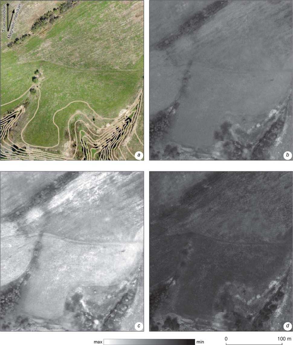
Fig. 1. Orthophotomap (N.G. Vorobyeva, Finco LLC ООО; contour interval, 2.5 m) of Kushmanskoye III ( a ) and reflectance maps in bands Green ( b ), NIR ( c ), and Red ( d ).
Areas attributable to class 4 correspond to the replaced occupation layer. These possibly mirror the extreme situation in which the topsoil horizon consists primarily of redeposited parent material. In this case, large amounts of the destroyed occupation layer were displaced into subordinate landforms where the transported layer had been formed (class 1). The distribution of replaced areas is representative: in the promontory part (at the top of the local watershed) and along the outer perimeter of the economic periphery.
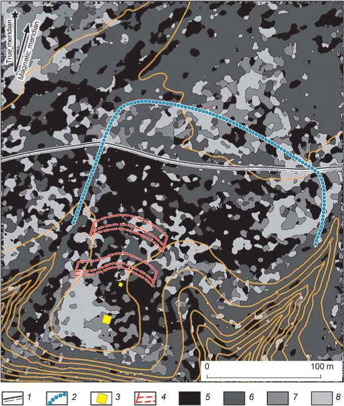
Fig. 2. Segmentation of multispectral images of Kushmanskoye III (contour interval, 2.5 m). 1 – road; 2 – boundaries of the economic periphery; 3 – test pit and excavation; 4 – fortifications; 5–8 – areas of classes 1 ( 5 ), 2 ( 6 ), 3 ( 7 ), and 4 ( 8 ).
Areas of classes 2 and 3 probably correspond to an intermediate situation in which some interlayers of the original occupation stratum have been preserved, or the parent material is overlain by a thin transported layer with high values of chemical and biological indices. Such a variant is present in the promontory part of the settlement, in the excavation area attributable to class 3. In the excavation, the total thickness of humified strata outside the deepened objects does not exceed 0.45 m (Modin, Ivanova, Zhurbin, 2021).
Generally speaking, segmentation of multispectral imaging data suggests that on gently sloping surfaces of promontories, the superficially disrupted and transported occupation layer can be recorded. Areas of the replaced layer are located at the tops of watersheds. Evidence of the original culture-bearing deposits can be represented by linear areas of the transported occupation layer on slopes of the promontory, if their location matches that of the replaced layer. Areas of the transported layer are presumably located along the perimeter of the residential, economic, and production zones of the settlement.
The Kushmanskoye fortified settlement of Uchkakar
Segmentation of the Uchkakar area (Fig. 3) largely coincides with that of Kushmanskoye III. A well-preserved occupation layer is detectable in the medial part of the settlement. Areas of the superficially disrupted layer up to 1.5 m thick (excavation 1) belong to class 1. In the western and northwestern parts, the thickness decreases to 0.8–0.9 m (excavation 3). This area is mostly attributed to class 2. The tendency of change in the thickness
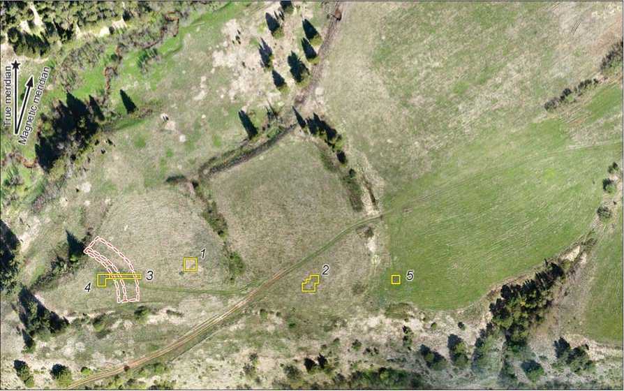
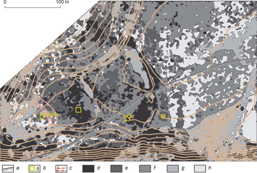
Fig. 3. Orthophotomap and segmentation of multispectral images of the Kushmanskoye fortified settlement of Uchkakar (base by N.G. Vorobyeva, Finco LLC; addition by R.P. Petrov, Physical-Technical Institute, Udmurt Federal Research Center, Ural Branch RAS; contour interval, 2.5 m).
a – road; b – excavation and its number; c – inner fortifications; d–h – areas of classes 1 ( d ), 2 ( e ), 3 ( f ), 4 ( g ), and 5 ( h ).
of occupation layer accords with geophysical and geobotanical data (Mezhdistsiplinarnye issledovaniya…, 2018: 51–54, 202–207). Dry meadow vegetation prevails in this part of the settlement. Areas of class 1 located at the junction of the medial rampart and the field’s road, as well as in the recultivated excavations, correlate with sporadic occurrences of moisture-loving ruderal plants.
In the outer part of the settlement, delimited by salient features of fortifications, the occupation layer is in a significantly poorer state of preservation. In the center, the superficially disrupted layer is traceable, with its thickness comparable with that in the northwestern part of the medial portion of the settlement (class 2). The area is mostly occupied by the replaced layer, with preserved thin interlayers of the original culture-bearing deposit (class 3). This observation is confirmed by data from excavation 2, where the thickness of the humified stratum does not exceed 0.5 m (Ibid.: 91–97). According to geobotanical data (Ibid.: 202–207), in this place, in contrast to the previous area, the vegetation points to a dry meadow with almost total absence of moisture-loving plants. The southeastern area of the outer part of Uchkakar, attributable to class 1, is probably an accumulation zone of the transported layer, transferred by planar erosion to the subordinate area on the gently sloping surface of the site. The tendency of change in the thickness of the occupation layer generally agrees with the results of geophysical studies (Ibid.: 54–57).
Apparent zones of the transported layer are present in flattened ditches of the medial and outer fortification lines (class 1 in the central and northern parts of the ditches). Localized areas occupied by moisture-loving plants on the background of dry meadow vegetation serve as additional indicators of deepened medieval constructions. For example, the ditch leveled out by plowing at the outer rampart marks a dense growth of reed canary grass ( Phalaroides arundinacea ) (Ibid.: 202–207).
At Uchkakar, same as at Kushmanskoye III, linear areas of the transported occupation layer were recorded on the slopes of the promontory (Fig. 3). Such areas are located on the southern slope of the hill, and run along the inner, medial, and outer parts of the settlement. They were probably formed not only by slope-wash erosion, but also by solifluction. Processes of this sort arise on south-facing slopes, in places with the soil horizon affected by seasonal freezing. The transported layer serves as an additional evidence of the thick original occupation layer that existed in all three structural parts of the settlement.
The thickness of occupation layer changes significantly in Uchkakar’s inner part, located on the tip of the promontory. In the area adjoining the ruined fortifications, zones of the superficially disrupted (class 2) and replaced (class 3) occupation layers were recorded. Excavation 4, located in this area outside deepened objects, revealed the superficially disrupted occupation layer, 0.8–0.9 m thick (Ibid.: 69–84). This coincides with the situation observed in excavation 3 in the medial part of the settlement. The rest of the inner territory is attributed to classes 4 and 5—area where the occupation layer was not formed, or has nearly entirely disappeared. Geophysical prospection and soil-coring confirmed the minimal thickness of the humified stratum in this part of the settlement: the layer of modern soil, 0.3 m thick, overlies the parent material, consisting of carbonate clay (Ibid.: 49–51). It is possible that in this case we are dealing with an extreme condition of the replaced occupation layer: soils of culture-bearing deposits were shifted completely to subordinate landforms. Indicators of this situation are segments of the transported layer of class 1 located around the tip of the promontory, mostly on the southern and southwestern slopes. Plants of dry meadow prevail in this area, and small two-storied forest communities are formed there (Ibid.: 202–207). In the Middle Ages, supposedly, both the territory of the settlement and adjacent areas were permanently cleared of trees and bushes.
Areas representing class 4 correspond mostly to zones with a dense growth of trees and shrubs. In deep parts of gullies and on river floodplains, anthropically undisturbed vegetation consists of mixed forest dominated by dark coniferous plants (Ibid.). Dense thickets of wild rose cover ridges of ramparts in the medial and outer fortification lines. These features are especially salient on the orthophotomap (Fig. 3).
Thus, judging by the distribution of vegetation, it can be assumed that the dense building area at Uchkakar included the site’s medial and outer parts. Large segments of the superficially disrupted occupation layer have been preserved there. The promontory area (the inner part of the settlement) and the external unfortified part of the settlement were used less intensively. The presence of the replaced layer may be caused not only by small thickness of the original culture-bearing deposits, but also by a greater inclination of the land’s surface at the top of the promontory. As at Kushmanskoye III, segments of the thick original occupation layer are marked by linear areas of the transported occupation layer on slopes of the promontory.
Kushmanskoye II
Statistical analysis revealed a distribution of vegetation that differs fundamentally from the situation at the sites described above (Fig. 4). Areas of the superficially disrupted layer are actually absent at the settlement. At Uchkakar and Kushmanskoye III, this layer is present on a large portion of the sloping surface. At Kushmanskoye II, however, localized “inclusions” are recorded only in linear depressions located on tops of gullies, and in a
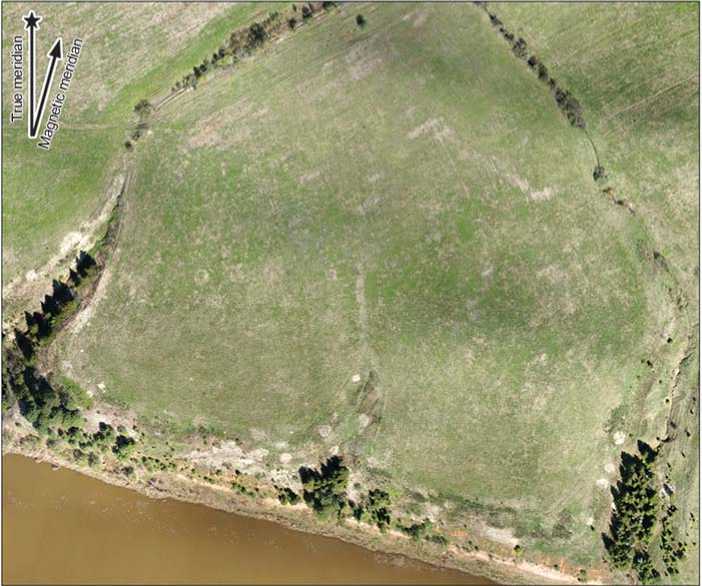
Fig. 4 . Orthophotomap and segmentation of multispectral images of Kushmanskoye II (base by N.G. Vorobyeva, Finco LLC; addition by R.P. Petrov, Physical-Technical Institute, Udmurt Federal Research Center, Ural Branch RAS; contour interval, 2.5 m). a – test pit; b–e – areas of classes 1 ( b ), 2 ( c ), 3 ( d ), and 4 ( e ).
shallow dry valley in the center of the settlement. Original soils at such areas are buried under the transported soils. A rather thick transported layer was traced in test pit 5 (Kirillov, 2011).
Areas of class 2 occupy the largest territory. From the experience of segmenting Kushmanskoye III, they are represented by the thin replaced layer whose segments usually adjoin areas of the superficially disrupted stratum (see Fig. 2 and 3). It is noteworthy that at Kushmanskoye II, the layer of class 2 prevails not only on the entire gently sloping surface of the promontory, but also on walls of gullies (see Fig. 4).
Segmentation of multispectral images, thus, demonstrates rather homogeneous vegetation throughout the gently sloping surface of the promontory. The noted variations are associated with the lowering of the relief and the plowing practiced in the 20th century (in the northern part of the site). The vegetation cover of Kushmanskoye II is comparable with that observed in areas with the replaced occupation layer at other sites in the Kushman cluster. It is possible that in the Middle Ages, the entire gently sloping surface of the promontory was evenly covered with organic matter—possibly, manure and household rubbish. Such a structure of segmented imagery, combined with geophysical, palynological, and archaeological data, upholds the conclusion that no traces of the settlement are present, and that this territory was possibly part of the agricultural development zone.
Conclusions
The interpretation of segmented imagery resulting from the statistical analysis of multispectral data is based on the following considerations. Vegetation intensity evaluated by multispectral images depends on the thickness of the humified layer and on the amount of anthropogenic organic remains in the soil. Tentative conclusions about the presence of the occupation layer varying in thickness can be based on the analysis of the configuration of areas on segmented images and their correlation with landscape features. The assessment of the archaeological context and of the preservation of the occupation layer (superficially disrupted, replaced, or transported) is possible only through the use of additional geophysical and soil data and the findings of targeted excavations. Step-by-step enhancement of interpretation with the use of those data is the key principle underlying multidisciplinary studies at the Kushman cluster of sites.
Acknowledgements
This study was supported by the Russian Science Foundation (Project No. 22-28-00189). Classification of the occupation layer segments was suggested by A.V. Borisov (Institute of Physicochemical and Biological Problems in Soil Science RAS, Pushchino). Geobotanical studies were carried out by A.Y. Sergeev (Institute of Archaeology RAS, Moscow).
References Occupation layer at the Kushman cluster of sites (9th–13th centuries) according to multispectral imaging data
- Agapiou A. 2020 Evaluation of Landsat 8 OLI/TIRS level-2 and Sentinel 2 level-1C fusion techniques intended for image segmentation of archaeological landscapes and proxies. Remote Sensing, vol. 12 (3): 579-598.
- Arkheologicheskaya karta severnykh raionov Udmurtii. 2004 A.G. Ivanov, M.G. Ivanova, T.I. Ostanina, N.I. Shutova. Izhevsk: UIIYaL UrO RAN.
- Calleja J.V., Pages O.R., Diaz-Alvarez N., Peon J., Gutierrez N., Martin-Hernandez E., Relea A.C., Melendi D.R., Alvarez P.F. 2018 Detection of buried archaeological remains with the combined satellite multispectral images and UAV data. International Journal of Applied Earth Observation and Geoinformation, vol. 73: 555-573.
- Carmona J.A.S., Quiros E., Mayoral V., Charro C. 2020 Assessing the potential of multispectral and thermal UAV imagery from archaeological sites: A case study from the Iron Age hillfort of Villasviejas del Tamuja (Cáceres, Spain). Journal of Archaeological Science: Reports, vol. 31. Article 102312.
- Chupina D.A., Zolnikov I.D., Smolentseva E.N., Lashchinsky N.N., Nikulina A.V., Kartoziya A.A. 2018 Geoinformatsionnoye kartografirovaniye territorii po reaktsii k issusheniyu i uvlazhneniyu (yug Zapadno-Sibirskoi ravniny). Izvestiya RAN, Ser. Geografi cheskaya, No. 5: 81-90.
- Kallepalli A., Kumar A., Khoshelham K., James D.B. 2016 Application of spectral and spatial indices for specifi c class identifi cation in Airborne Prism Experiment (APEX) imaging spectrometer data for improved land cover classification. Proceedings of SPIE: Earth Resources and Environmental Remote Sensing/GIS Applications VII (Edinburgh), vol. 10005: 246-265.
- Kirillov A.N. 2011 Istoriko-kulturnye issledovaniya Potapovskogo mestorozhdeniya v Krasnogorskom raione i razvedochnye raboty na Kushmanskom II i III selischakh v Yarskom raione Udmurtskoi Respubliki. In Archives IKMZ UR “Idnakar”. D. 02-03.
- Kirillov A.N. 2012 Arkheologicheskiye raboty po opredeleniyu granits obiektov arkheologicheskogo naslediya v Glazovskom raione i razvedochnye raboty v Yarskom raione Udmurtskoi Respubliki. In Archives IKMZ UR “Idnakar”. D. 02-03.
- Lasaponara R., Masini N., Holmgren R., Forsberg Y.B. 2012 Integration of aerial and satellite remote sensing for archaeological investigations: A case study of the Etruscan site of San Giovenale. Journal of Geophysics and Engineering, vol. 9 (4): S26-S39.
- Mezhdistsiplinarnye issledovaniya Kushmanskogo gorodishcha Uchkakar IX-XIII vv.: Metodika kompleksnogo analiza. 2018 I.V. Zhurbin, E.E. Antipina, M.G. Ivanova, E.Y. Lebedeva, R.N. Modin, A.Y. Sergeyev, L.V. Yavorskaya. Moscow: Taus.
- Modin R.N., Ivanova M.G., Zhurbin I.V. 2021 Struktura kulturnogo sloya i khronologiya Kushmanskogo III selishcha X-XII vv. v basseine r. Cheptsa (po dannym noveishikh issledovaniy). Rossiyskaya arkheologiya, No. 3: 97-115.
- Noviello M., Ciminale M., De Pasquale V. 2013 Combined application of pansharpening and enhancement methods to improve archaeological cropmark visibility and identifi cation in QuickBird imagery: Two case studies from Apulia, Southern Italy. Journal of Archaeological Science, vol. 40 (10): 3604-3613.
- Sharafi S., Fouladvand S., Simpson I., Alvarez J.A.B. 2016 Application of pattern recognition in detection of buried archaeological sites based on analysing environmental variables, Khorramabad Plain, West Iran. Journal of Archaeological Science: Reports, vol. 8: 206-215.
- Thabeng O.L., Merlo S., Adam E. 2019 High-resolution remote sensing and advanced classifi cation techniques for the prospection of archaeological sites’ markers: The case of dung deposits in the Shashi-Limpopo Confluence area (southern Africa). Journal of Archaeological Science, vol. 102: 48-60.
- Verhoeven G., Vermeulen F. 2016 Engaging with the canopy - multi-dimensional vegetation mark visualisation using archived aerial images. Remote Sensing, iss. 8 (9): 752-768.
- Zhurbin I.V. 2021 Unfortified settlements of the Cheptsa culture (9th- 13th centuries): Ambiguity of interpretation and delimitation of boundaries. Archaeology, Ethnology and Anthropology of Eurasia, vol. 49 (1): 85-93.
- Zhurbin I.V., Borisov A.V., Nazmutdinova A.I., Milich V.N., Petrov R.P., Ivanova M.G., Modin R.N., Knyazeva L.F., Vorobyeva N.G., Zinchuk S.V. 2019 The use of remote sensing, geophysical methods and soil analysis in the study of sites disturbed by agricultural activity. Archaeology, Ethnology and Anthropology of Eurasia, vol. 47 (2): 103-111.
- Zlobina A.G., Shaura A.S., Zhurbin I.V., Bazhenova A.I. 2021 Algorithm for statistical analysis of multispectral survey data to identify the anthropogenic impact of the 19th century on the natural environment. Pattern Recognition and Image Analysis, vol. 31 (2): 345-355.
