Pechora routes of the Northern scientific and commercial expedition

Автор: Astakhova Irina S.
Журнал: Arctic and North @arctic-and-north
Рубрика: Northern and arctic societies
Статья в выпуске: 40, 2020 года.
Бесплатный доступ
The article considers the history and the study of the Russian North completed by the Northern scientific and commercial expedition. The main directions of research and the versatility of expeditions in 1920-1924 are reflected. The geological problems that were solved by expeditions to the Arctic territories of the northeastern part of the East European platform, the Timan Ridge, and the northern part of the Ural fold system with its continuing island chain (Vaigach and Novaya Zemlya) are considered. The theoretical conclusions of A.A. Chernov are reflected. The existence of a vast coal basin, the discovery of a great amount of mineral deposits, the mapping of the North of the Urals, and the area near the Pechora are recorded. The results of the described ethnographic research are the first important components in the study of cultural heritage. Despite the multidisciplinary nature and the amount of research carried out in the Arctic, many expeditions were scattered and ineffective; the poor coordination of scientific research that time is also noted by modern researchers of the history of the Arctic development. In 1929, after the reorganization of the Geolkom, on its basis, the Main Geological Exploration Department was formed, and it continued numerous studies of the Pechora region.
Scientific research, north expeditions, pechora region, geology, chernov's group
Короткий адрес: https://sciup.org/148318384
IDR: 148318384 | УДК: [910.4(470.1)+55(470.1)](045) | DOI: 10.37482/issn2221-2698.2020.40.206
Текст научной статьи Pechora routes of the Northern scientific and commercial expedition
Organization of the Northern Scientific and Commercial Expedition
The history of the Northern Scientific and Industrial Expedition (abbreviated - Sevek-speditsiya), its activities and the results of scientific - search and industrial works, which ushered in the development of Arctic regions and many industries in the Russian North, as well as the emergence of new settlements and transportation routes dedicated many works of scientists and local historians. The scale and versatility of the expedition's activities are partially covered in some generalizing monographs by M.I. Belova [1], A.V. Koltsova [2], D.P. Belyaeva [3], E.P. Wittenburg [4], as well as in individual publications [5, 6, 7, 8, 9]. Despite the relatively good coverage in the historiography of Soviet Arctic research in the 1920s, scientific research activities in the Pechora Territory did not become the subject of a separate study.
Order No. 9792 of the Presidium of the Supreme Economic Council of March 4, 1920, stated: “For scientific and practical research and the accompanying use of natural productive forces, mainly animal, fish and reindeer husbandry in the Russian North, to establish a Northern Scientific fishing expedition”. The new organization was given the task of “the production of scientific and technical research of the natural productive forces of the Russian North as well as the management and coordination of scientific and practical work carried out by all bodies and institutions on the ground” [9, Andreev A.O. et al., p. 7]. Samoilovich R.L. was appointed the head of the Scientific
∗ For citation:
Council of the Sevexpedition. In 1921 he wrote: “Under extremely difficult conditions… it would be an excessive luxury to send an entire expedition to study this or that scientific and practical issue. On the contrary, in each expedition, in each detachment, specialists should be represented, if possible, at least the main branches of knowledge” [9, Andreev A.O. et al., p. 8]. In this regard, famous scientists were invited to the Academic Council: K.M. Deryugin – a zoologist and hydrobiologist, N.M. Knipovich – a zoologist, ichthyologist, oceanologist, geographer, academician of the Russian Academy of Sciences, A.E. Fersman – a mineralogist, crystallographer, geochemist, Yu.M. Shokalsky – an oceanographer, meteorologist, geographer, etc. Thus, the Sevexpedition was created as a leading organization coordinating all research work in the Arctic.
A special place in the plans of the Northern scientific and fishing expedition in the early 1920s was assigned to the study of the Pechora Territory, which was of strategic importance associated with the oil and gas and coal industry [10, Ievlev A.A.]. This is confirmed by the fact that the creation of the Sevexpedition took place based on the Commission for the North and the Pechora expedition. The beginning of the Pechora expeditions work is associated with the creation in 1919 of the Commission for the Use of the Natural Productive Forces of the Russian North (abbreviated as the Commission for the North). It consisted of representatives from the People's Commissariat of Trade and Industry (Yu.V. Pyatigorsky), the Supreme Council of the National Economy, the People's Commissariat of Agriculture, the Polar Commission (I.P. Tolmachev), and the Commission for the Study of the country's natural productive forces of the Academy of Sciences (A.E. Fersman), the Northern Department of the People's Commissariat of Railways (D.D. Rudnev). Well-known scientists who were already involved in the study of the Russian North were involved as scientists: R. L. Samoilovich - the former head of mining expeditions in Spitsbergen and the North of Russia, N. A. Kulik - a representative of the Geological Committee and a geologist of the Museum of the Academy of Sciences, N.S. Tikhonov is a mining engineer. In 1919, the first Pechora expedition took place, which became the largest event of the Commission for the North. Economic research was carried out during the expedition. Issues of the reorganization of suede and grinding production, salt and oil industries were considered, butter and dairy business, hunting, fishing, and reindeer husbandry were studied [10, Ievlev A.A.]. In the same year, the Ukhta Bureau was organized as part of the Commission for the North, the work of which was aimed at the survey and practical use of the Ukhta oil-bearing region. The bureau included R.L. Samoilovich, B.K. Likharev, B.V. Sab-anin. The expedition work results in 1919 were presented at a meeting of the Commission for the North. N.A. Kulik, head of the Pechora expedition, emphasized the significance of the results obtained, and R.L. Samoilovich noted the increased role of the Pechora expedition [11, Silin V.I., p. 134]. On February 19, 1920, in Vologda, an interdepartmental meeting was held at the Special Food Commission of the Northern Front. The question of creating an enlarged body for the study of the Russian North was raised. There, N. A. Kulik proposed to expand the Pechora expedition's activities and include in the sphere of interests of the territory gravitating towards the Arctic Ocean. Already on February 25, the Revolutionary Military Council of the 6th Army appealed to the Chairman of the Council of People's Commissars VI Lenin with a request to support the decision of the meeting and create a new institution with a diversified and multidisciplinary nature [8, Emelin M.A., p. 36].
Research of the Sevexpedition in 1920–1924
The first geological work was carried out by the Sevexpedition in the summer of 1920, mainly on the Kola Peninsula; in particular, P.V. Wittenburg headed the Murmansk, and A.E. Fersman led the Kola detachments. In subsequent years, the detachments under the leadership of A.E. Fersman studied the Khibiny mountains, which evoked exclusively mineralogical interest with unique lamprophyllites, eudialytes, enigmatites, and other new rare minerals [12, Proceedings].
In 1921, Professor P.V. Wittenburg explored part of the Kola Peninsula and the northern part of the Kaninsky Peninsula and, together with R.L. Samoilovich, part of the Barents Sea to No-vaya Zemlya. In addition to geologists, the expedition included botanist M. I. Nazarov, hydrometeorologist B.G. Dikstveld. The captain of the schooner “Charlotte” F.M. Valnev. The expedition lasted from August 15 to September 25. During the expedition, the coastline's composition and structure were studied, a change in the landscape from a flat, abraded to mountainous alpine type in the Matochkin Shar zone was noted. For the first time, the beginning of ongoing glaciation was established in the Yuzhnaya Sulmeneva Bay. Scientists collected paleontological collections and remarkable herbarium and material on soil science. In 1921, under the leadership of the geologist N.A. Kulik in the southwestern part of Vaigach Island, in the Varneka Bay, the first polymetallic veins were discovered. In the same detachment G.F. Drucker, together with military engineer A.N. Kazakav and a student at the Geographical Institute, E.L. Bazhenova, surveyed the coast and performed ichthyological studies, assessed the prospects of fishing [13, Works, p. 13].
In 1923, R.L. Samoilovich was engaged in geological work on the islands of Vaigach and No-vaya Zemlya. The expedition aimed to study geographically and geologically the western coast of Novaya Zemlya from Bezymyannaya Bay to Matochkin Shar, as well as a trip to the central part of the archipelago to find out the distribution of glaciers and determine astronomical points. The expedition consisted of six people: R.L. Samoilovich, G.P. Gorbunov, K.V. Kuznetsov, S.Ya. Mittelman, S.G. Natanson and two sailors. On August 24, the steamer “Vorovsky” delivered the expedition to the roadstead of Malye Karmakul, and on October 9, it arrived back in Arkhangelsk. Most of the research was carried out in the central part of the island on foot routes, during which more than 50 km were covered. We studied mountain ridges, composed of sandstones and clay shales, the height of which reached 300m. The coastline was precisely fixed with the establishment of astronomical points. In 1924, the expedition was divided into two groups: the first studied the geological structure of the eastern coast of the southern island of Novaya Zemlya, and the second – the western coast of Novaya Zemlya in Pukhovy Bay, where they studied relict lakes, Arctic char fishing, and rookeries. On the eastern bank, four astronomical points were identified (Kamenka River, Savvina River, Abrosimov Bay, and Schubert Bay) and one point in Petukhovsky Shar. Also, an in- ventory of the shores was made, and the geological structure was studied. In practical terms, this expedition was of great importance, having found many animals and fish in the rivers and lips of the eastern coast [14, Samoilovich R.L., p. 67].
In 1920, Professor V.K. Soldatov, together with the hydrobiologist Professor S.A. Zernov, carried out ichthyological studies on the Pechora River. In the report, V.K. Soldatov characterized the ichthyological wealth of Pechora, highlighting the following types of fish: lamprey, salmon, nelma, omul, peled, vendace, whitefish, broad whitefish, etc. [15, Soldatov V.K., p. 72].
Beginning in 1921, large-scale expeditionary investigations began in the Pechora area (Fig. 1). More than 20 teams solved various complex tasks for four years, including mining and geological, geographical, biological, ethnographic, economic, and statistical research.
In 1921, along the Pechora, Izhma, and Usa, the Pechora economic detachment worked, studying peasant farms, trades, population registration, and other economic and geographical issues.
Ethnographers of the Geographical Institute V. Ya Vitskaktin, D.D. Travin, E.A. Dylevsky carried out ethnographic research of the Sevexpedition in the Middle and Lower Pechora.. The base for ethnographic research was Ust-Tsilma. Together with the local population (Samoyeds), scientists roamed the Bolshezemelskaya and Kaninskaya tundra, studying material and spiritual life, studying the Komi-Zyryan people and Russian population, collecting ethnographic and zoological collections. Professor V.G. Bogoraz, in a report on the results of the work of ethnographic detachments, pointed out: “The economic and everyday life of Pechora is a kind of combination of old and new principles, which fight among themselves, but partly coexist together” [16, Bogoraz V.G., p. 7]. Later, V.G. Bogoraz initiated the “Committee for Assistance to the Peoples of the Northern Outskirts” (Committee of the North), whose task was to improve the economic, cultural, and sanitary living conditions of the peoples of the North.
Several complex geological teams worked on the territory: Pinezhsky, Bolshezemelsky, and Verkhnepechorsky. M.B. Edemsky led the Pinega expeditions. The first results of geological work on the rivers Pinega, Sotke, and Kuloy were published in 1926 in Proceedings of the GM of the Academy of Sciences of the USSR. Edemsky M.B. carried out expeditionary work in 1921 and 19231926 in Pinega and Kuloy. The generalization of the obtained materials was the monograph “Gypsums of the Northern Territory”, published in 1931. The Pinezhsky region was illuminated from the point of view of the possibility of gypsum deposits use.
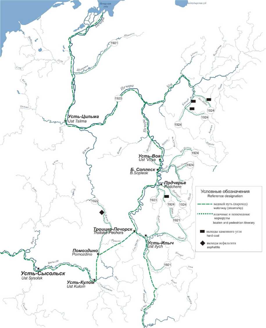
Fig. 1. Route map of expeditions of 1920–1924 in the Pechora area.
The Bolshezemelsky detachment included D.D. Rudnev, A.A. Grigoryev, G. D. Richter and V.Z. Bulwanker. In the Proceedings of the Northern Expedition for 1922, D.D. Rudnev cites a report on the work of the Bolshezemelsky detachment, which indicates that they managed to climb the Shapkina river for 200+ versts. Economic studies were carried out, according to the results of which the richness of floodplain and above floodplain forest thickets of black and red currants, mountain ash, which makes this area attractive for hunting animals (brown bear) and birds (capercaillie, black grouse, partridge, geese, swans) [17, Rudnev D.D., p. 48]. In 1921, the expedition took about a month to get through Arkhangelsk along the Arctic Ocean to the mouth of the Pechora
River, then climb to the mouth of the Shapkin River and dragged down the river by boat. Almost all components of the geographic complex were described in detail, the structure of geological formations was considered, two moraine and interglacial (marine) horizons were identified, the structure of the relief and soils, including permafrost formations and vegetation, was studied. From the works of A.A. Grigoryev in the geographical literature began to use the concept of “Bol-shezemel'skiy ridge” [18, Grigoryev A.A.]. The mentions and reflections of A.A. Grigoryev concerning finds on the Shapkin River, alluvial coal deposits: “Even earlier, between stations 17 and 18, the river alluvium turned out to be coal shale, and between 20 and 21, pieces of coal were found, apparently of Jurassic age, highly similar to the coals in the alluvial sediments of Novaya Zemlya; such coals were found further, upstream, but were not noticed below ”[18, Grigoryev A.A., p. 21].
Geological work of the Verkhnepechora detachments
In 1921, the geologists of the Chernovsk group began their regular expedition work on the territory of the Pechora Territory: A.A. Chernov, V.A. Varsanofyeva, T.A. Dobrolyubova, E.D. Sosh-kina, M.I. Shulga-Nesterenko. Expeditions were carried out by carts and boats, in hard-to-reach places, pedestrian crossings were carried out (Fig. 1). The most acceptable means of transport on the roads was a one-wheeled car and a tarantass. Eighteen-year-old G.A. Chernov, son of A.A. Chernov, who first visited the Pechora area in 1924 and for the next sixty years studied the geography, archeology and geology, wrote: “Over the years I became convinced that it is more convenient to use a one-wheeled car on the Pechora roads than a tarantass. A one-wheeled gives only one push on bumps, a tarantass - two, and all the protection against bruises is a cozy bed of hay” [19, Chernov G.A., p. 25] (Fig. 2.).
In the first years of the expeditions, scientists working in the Pechora area faced great difficulties and problems. It was primarily due to the lack of good topographic maps, lack of transport and manpower, and poor supply of field materials. An example is a conversation between a conductor and A.A. Chernov in the route to the top of Tima-iz: “Is it still far from the hut on Ilych?” – After thinking, he replies: “If this swamp is familiar, then close, if unfamiliar, then it is still far away”, - “And what kind of swamp? Familiar or unfamiliar?” – I asked. “I don’t know,” - the guide answers slowly… ” [19, Chernov G.A., p. 13].
In 1921, the work of the Chernovsk group took place on the river. Let us see where the study of mainly Paleozoic deposits begun. The task was to build a geological profile of the lower course of the Ilych River, make a route survey and make a section of the upper reaches of the river, map the most important peaks of the Northern Urals. Based on the tasks set, the work area was divided as follows: V.A. Varsanofyeva studied the outcrops of Silurian rocks in the basin and summits of the Northern Urals on the Ilych River; T.A. Dobrolyubov and E.D. Soshkina worked in the river basins of Vuktyl, Podcherem, and Shugor; A.A. Chernov and M.I. Shulga-Nesterenko studied to the north in the basin of the Kosyu River (Fig. 3). The detachments united in the upper reaches of Ilych, which made it possible to jointly conduct routes along the tributaries Pirs-yu, Uk-yu, Egra-Lyagi, Shezhim and rivers Kozhym and Ispered [13, Works, p. 19].
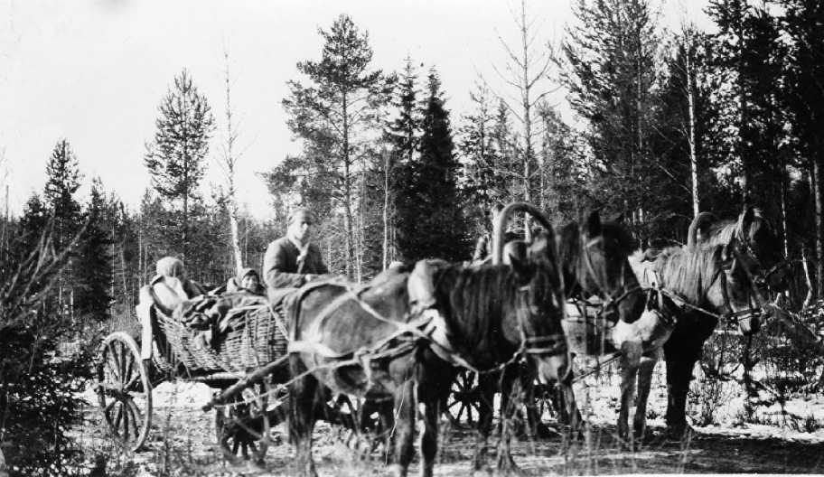
Fig. 2. Pechora tract (in the cart of M.I. Shulga-Nesterenko, T.A. Dobrolyubov). Photo by A.A. Chernov. 1924 Fund of Funds of A.A. Chernov’s Geological Museum .
Geographically, the following ridges were consistently described from west to east: upper Carboniferous limestones of the Isperid rocks, lower Carboniferous quartz sandstones, shale, and limestones of An-yu Parma and Ydzhid Parma. To the east, in the river basin of Ilych, three meridi-anally located ridges were identified: the first included nine massifs, including the famous Torre-porre-iz, the central ridge with the Man-pupuner and the eastern ridge known as the Poyasoviy Kamen’.
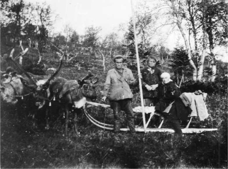
Fig. 3. Varsanofyeva V.A. (sitting) with guides on Ust-Ilych (1920s). Funds of A.A. Chernov’s Geological Museum.
Geologically, in the basin of Ilych, a complete section of Paleozoic sediments from ancient crystalline shales to Permian carbonate rocks were identified, which gave a general idea of the geological structure of the western slope of the Northern Urals. Varsanofyeva V.A., in the veins of the southeastern part of Kychil-iz, found the presence of iron luster and copper ore, on the northern slope of Kozhim-iz - ocher deposits, used by locals to paint sledges and household items. In the southern part of Man-Khan-Kham, locals discovered smoky quartz. Lead ores of Shatym-Priluka were studied, exploration of which was carried out in 1911 by mining engineer N.I. Erassi.
Unconditional practically interest was aroused by the findings of graphite deposits. Graphite shale is a metamorphosed coal bed of the Lower Carboniferous age. The thickness of the layers reaches 6 m. The results of geological work on Ilych gave the foundation to A.A. Chernov’s suggestions that in the Permian period, the conditions of sediment deposition towards the north became more favorable for coal formation.
In 1922, due to a lack of funds, A.A. Chernov did not study the Northern Urals, but worked in the Izhma region. Back in 1902, the scientist discovered inclusions of asphaltites in the rocks on the right bank of the Izhma River at the Leg-Kost threshold. Upon completion of the work, A.A. Chernov makes a scientific report on the prospects for the industrial development of the Izhma asphalt region in the Pechora area, the operation of which will begin in the 1930s.1
In 1923 in the river basins of Podcherom and Shchugor carry out joint work by A.A. Chernov, V.A. Varsanofyeva, M.I. Shulga-Nesterenko and T.A. Dobrolyubova. Climbing up the river, Aleksandr Aleksandrovich, together with Vera Aleksandrovna, studied the city of Tima-Iz, then they descended into the basin of the Ilych river. At the top of Tim-iz, built of quartzite sandstones, A.A. Chernov discovered a large magnetic anomaly, for the study of which in 1926 an expedition was assembled under the leadership of Professor V.F. Bonchkovsky.
A year later, T.A. Dobrolyubova continues to study the same sections. She succeeded, on the basis of faunistic and topological data, to describe the tectonics and stratigraphy of the Carboniferous deposits of the river. Let us underline. In addition to descriptions of ancient sediments, her descriptions of karst forms are also interesting: a cave, sheds, etc. When describing the stratigraphy of this region, T.A. Dobrolyubova noted that “... Vuktyl flows throughout its entire length in Artinsk and glacial sediments” [20, Dobrolyubova T.A., p. 41]. One of the main achievements of T.A. Dobrolyubova discovered a coal-bearing strata: “The clayey-sandstone suite, underlying the limestones and protruding to the east of them, is of not only scientific but also practical interest. In its outcrops at Varkyan-yol and Yugyd-yol, interlayers and layers of coal appear among clay shales ” [21, Dobrolyubova T.A., p. 24].
In 1923, in the river basin of Necha a search for coal was carried out at the expense of the Komi Autonomous Region. As a result of the exploration, powerful coal outcrops were discovered. “Here, for 6km, there are three outlets, apparently, of one complex coal stratum with a maximum thickness of up to 8 meters, and the share of waste rocks in the latter case accounts for only about 0.5m” [22, Chernov A.A., p. 5]. Coal samples and a drilling log were delivered to Gosplan. To verify the data, the Bureau of the State Planning Commissions proposed A.A. Chernov to explore the river basin of Kos-yu. In 1924, a meeting of the Special Commission of the Exploration Subdivision of the Geological Committee of the Supreme Council of the National Economy (together with the coal and Ural sections) was held on the question of setting up exploration for coal in the Pechora area. It was decided to concentrate intelligence on the rivers of Kozhim, Kosyu and Necha. Due to the help of the Geological Committee and the leadership of the Autonomous Region of Komi in 1924, the Verkhnepechorsk detachment of the Northern Scientific and Commercial Expedition led by A.A. Chernov studied coal-bearing deposits in the basin of the Kos-yu River with two detachments. The group of E. D. Soshkina together with G.A. Chernov examined the exits to the rivers of Usse and Bolshaya Inta. In the slope of the river of Bolshaya Inta, individual blocks and beds of sandstones and black shales of Permian age were found. The cleanup revealed two coal seams up to one and a half meters thick. In the memoirs of G.A. Chernov writes: “Elizaveta Dmitrievna perked up ... She said that Alexander Alexandrovich would be incredibly pleased with this finding ... Our campaign is far from unsuccessful” [19, Chernov G.A., p. 40]. The second group, consisting of A.A. Chernov, M.I. Shulga-Nesterenko and geologist V.P. Tebenkova, examined the outcrops on the rivers of Pechora, Usa, Necha, Bolshaya Inta, and Kos-yu. As a result, a map was built with outcrops of carboniferous sediments, bordering the Kos-yu coal basin from the west and east. On the Kosyu River, 22 km above the mouth of the river, they discovered a coal seam with a thickness of more than 1.6 m. Kozhim discovered a section of the Lower Permian deposits, in the upper part of which there was a coal-bearing stratum with a thickness of 6m. Thus, it was established that in the basin of Kos-yu contains two formations of coal of different ages - lower and upper Permian. According to A.A. Chernov, the basin had the shape of a wedge, the tip of which was directed to the south (the Kos-yu River basin), and the wider part to the north, and this northern boundary was still to be established by further research. In conclusion of his work, A.A. Chernov made large-scale forecasts for the discovery of high-quality coals in the Pechora area: “... If coking coals, especially low-sulfur coals, are found in large reserves, then the question of using these coals for the mining industry of the Urals may arise ... we have a vast area of the Northern Urals, which should take the path of industrial development” [23, Chernov A.A., p. 52].
The Geological Museum and the Archives of the Komi Science Center preserved handwritten materials, diaries, notebooks with descriptions of outcrops made during the expeditions of 1922–1925, as well as published scientific reports. Thus, the diary materials of V.A. Varsanofyeva “Description of outcrops along the tributaries of the Ilych from the Ust-Lyagi River and up-stream”2, scientific report by A.A. Chernov “Report of Upper Pechora geological party of the North scientific and commecrical expedition on geologiches FIR studies in the basin of Ilych”3. Funds of A.A. Chernov’s Geological Museum keep the field diaries of V.A. Varsanofyeva from the trip of 1924 and 1926. There are a lot of rewritten diary materials, where V.A. Varsanofyeva, already in Syktyvkar, gives a more detailed description, changes terms, makes corrections. For example, in outcrop No. 9 on the right bank of the Malaya Lyaga River, which flows into Ilych, she installed the Lower Silurian carbonaceous-calcareous shales and gives a description with a neat sketch: “On the surface of the cliff, leaves of soft mica are looming, overturned to the east. But they are not always clearly visible, they stand out (explanation of the author: words crossed out by V.A. Varsanofyeva). Slates also appear in the riverbed along the entire length ... below outcrop 9 ...”. The collected stone material of such expeditions was transported to central scientific institutions and kept in museums. Unfortunately, many collections have been lost. Only a few specimens were found in the VSEGEI Museum (St. Petersburg). In A.A. Chernov’s Geological Museum, few collections of A.A. Chernov and V.A. Varsanofyeva are kept by different periods (Fig. 4).
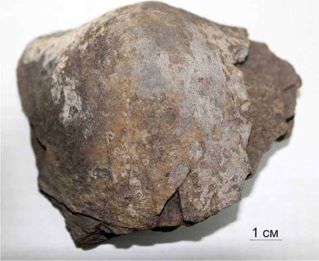
Fig. 4. Brachiopod, C1, Ilych River. Collected: V.A. Varsanofyeva. 1924. No. 153/2. Funds of A.A. Chernov’s
Geological Museum.
Ethnographic research of the Upper Pechora detachments
During the Pechora expeditions, in addition to geological and geographical research, geological scientists collected information about hunting and fishing, about the life of the local population, and made some zoological and botanical collections. A lot of ethnographic material is hidden in geological field diaries and some published materials.
It should be noted that the colonization of Pechora took place long time ago. Ethnically and ethnographically rich history of the population of the European North-East until the middle of the 20th century has not been regularly examined. A pronounced feature of the development of the Pechora area was the close territorial neighborhood and ethnocultural relationship of various nationalities. In this regard, the information obtained during geological expeditions along the Pechora River and its tributaries in the 1920s are the first ethnographic data on the crossing of ethnic boundaries between Komi, Russians, Mansi and Nenets.
By the early 1920s, whole villages were inhabited by Old Believers – the descendants of schismatics who fled to remote places from persecution. Often, Old Believers, “secrets” and Orthodox Christians could live in the same village. The routes ran through large settlements, villages, and individual huts of fishermen, which made it possible to conduct research on objects of material culture. So, the houses of the Old Believers were small, cramped and always dirty, as they were drowned in black. Each had separate dishes, for the visitors – separate appliances. There is a cross on the shrine, but they hid their gods and did not show them to strangers. There were no decorations in the huts, the dishes were also unpretentious. The clothes of the Komi hunters are simple and coarse, but the knitted stockings and linen shirts were decorated with colored ornaments. I was surprised by the hygiene of the local population, who paid special attention to the cleanliness of their hands, and they could wash their face and teeth at will. However, in the diary entries of T.A. Dobrolyubova notes that earlier the Komi seemed to her gloomy, silent due to the harsh living conditions, but in reality they turned out to be talkative and cheerful.
On expeditions, scientists replenished their supplies by exchanging with the local population. Mostly they traded sweets, sugar, soap, threads, needles, scarves, vodka for fish and meat. They described the life of the local population. Simultaneously with the study of material culture further attention was paid to the spiritual culture. Here the work was carried out mainly in two directions: folklore and religious beliefs.
In their diary entries, scientists described the prejudices of the local population and distrust of geologists, which did not allow to improve the efficiency of the work. The inhabitants were hostile to the penetration of geologists deep into the taiga, and even more so they did not understand how women could engage in geological research. From the memoirs of A.A. Chernov about a joint expedition with V.A. Varsanofyeva in 1923, when they climbed to the top of Kychil-iz: “There we saw a small herd of deer, and then two yurts. Near one of them stood the owner, who was obviously frightened ... He turned out to be a Komi and explained that he was very frightened. It seemed to him that Vera Alexandrovna had a rifle behind her back, although she only had a backpack ... And yet, after a while, he asked the worker how many deer we would take away” [24, Kalashnikov N.V. et al., p. 129].
According to the results of work on the Ilych River, V.A. Varsanofyeva wrote an essay in which she gave an interesting geographical and ethnographic description of the nature, life, and way of life of the local population (Fig. 5). The essay also provides characteristics of the clothing of the local population, and even their legends. One of the Mansi legends about the creation of the Earth: “Two loons flew down, one big, the other small. They wanted to get land from the bottom of the sea. At first they dived one after another, but they did not get anything from the bottom of the sea. Then we decided to dive together. We had dived twice and only the third time we reached sea day. They grabbed a piece of the bottom and swam out. They put the earth on the water. The earth began to grow more and more” [25, Varsanofyeva V.A.].
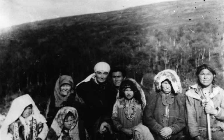
Fig. 5. Varsanofyeva V.A. with Mansi in the Subpolar Urals. Funds of A.A. Chernov’s Geological Museum.
In 1924, V.A. Varsanofyeva and T.A. Dobrolyubova communicated with locals of Pred-cherie. In her memoirs, T.A. Dobrolyubova describes a conversation about a global flood. She explained to them that there was no flood, as the Bible says, and the earth is changing all the time: where there was dry land, now the sea and vice versa. The locals treated the fossils differently. The guides, often accompanying geologists, knew some of the names (trilobites, ammonites, corals), and the common inhabitants were contemptuous and associated their origin with Satan.
And today, on the basis of the diary materials of scientists about trips to the Pechora area, it is possible to reconstruct the cultural picture of the world of preliterate societies, since at the beginning of the 20th century, a significant part of the local population of the territory was illiterate. One of the ways is reconstruction using worldview universals, which include the category of time - calendars. At the beginning of the 20th century, the most widespread wooden form of the Komi calendar was “pu svyatsi” (“wooden saints”). In many literary sources, this calendar is described as a wooden block tapering towards the ends with twelve half-edges (according to the number of months), on which there are notches signifying the days. Church holidays corresponding to the days were marked on the flat sides of the bar with special signs – “passes”. To mark the past days, the notches were sealed with wax or larch resin (Fig. 6) [26, Lipin V.B.]. In the diary of T.A. Dobrolyubova, she gives the following description, which is given from the words of Yevsey, the guide on the expedition to the Shchugor River in 1924: “It (the stick) was carved in the form of a hexagonal prism about 15-18 cm long, tapering towards the ends. In the middle, it is surrounded by a furrow that divides the prism in half, making six faces on one side and six on the other. On each rib, as many scars are made as there are days in a given month.
— Well, how to use it?
— These scars, covered with wax, these are Sundays, and these here mean our religious holidays. We remember it every day on the holy calendar”.
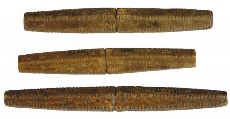
Fig. 6. The Komi calendar “pu svyatsi” [26, Lipin V.B.].
Scientists studied not only the religions and beliefs of the local population, but also their influence and manifestations in family and social life, revealed the role of one or another religious movement in the formation of the cultural and everyday specifics of a particular ethnographic group. For example, T.A. Dobrolyubova, in 1924, having visited the Shchugor River, stopping for the night in one of the huts, describes the difficult fate of a girl from Ust-Shchugor, who married an Old Believer. Old-believing customs did not allow her to sing and dance songs, wear shirts, outfits, and bras.
In the diary entries, you can find a description of the peculiarities of fishing, fur harvesting, forestry, and other resources. T.A. Dobrolyubova, in 1923, noted that the cedars were ruthlessly cut down, although the collection of pine nuts remained one of the industries. A simple method of extraction was described: a batch of cones was buried in the hot ash of a fire, after a while the resin disappeared, the steamed cone became soft, easily cleaned, and nuts were easily taken out of it.
Conclusion
Undoubtedly, the creation of the Northern Scientific and Fishing Expedition was an important step in the process of developing and studying the entire Russian North. In 1925 the Northern Expedition was transformed into the Institute for the Study of the North. In 1930, the institute was named the All-Union Arctic Institute. In 1958, due to the fact that the institute was involved in Antarctic research, it was renamed the Arctic and Antarctic Research Institute. In 1994, the institute was awarded the status of the State Scientific Center of the Russian Federation [9, Andreev A.O.].
The geological results obtained by the Sevexpedition turned out to be significant and fateful in the development of the Pechora Territory of the modern Komi Republic. In particular, A.A. Chernov draws important theoretical conclusions about the existence of a vast coal basin, a large number of mineral deposits have been discovered, and vast territories of the North of the Urals and Pepechorye have been mapped. The importance of it becomes clear to rough coal in the
North if we consider that in 1924 the import of coal to the European North-East of Russia amounted to 19.6 thousand tons [27, Ivanovskiy M.I.]. Later, Professor A.A. Chernov will single out a large coal-bearing basin and call it Pechora: “Thus, at present, in the North-East of the European part of the USSR, vague contours of a large coal basin, which is naturally called the Pechora basin, are beginning to appear” [28, Ugol’naya, p. 28]. The governing economic bodies of the Country of Soviets took very seriously the scientific foresight of A.A. Chernov. In 1925, the Arkhangelsk provincial and North-Eastern regional planning commissions published the following information: “The Bureau of Congresses for the Study of Productive Forces under the USSR State Planning Committee informed the North-Eastern Regional Planning Commission that the intelligence carried out by prof. A.A. Chernov, gave positive results. In his opinion, at present, vague contours of the coal basin are beginning to appear in the northeast of the European part of the USSR” [30, Arkhangelsk province, p. 16].
Subsequent geological surveys were already large-scale. The entire Pechora Urals was divided into territorial ten-verst sheets for geological survey. V.A. Varsanofyeva and N.N. Jordan continued to study the upper reaches of the Pechora with tributaries of the rivers Unyi and Ilycha. T.A. Dobrolyubov and E.D. Soshkin conducted a geological survey of 123 sheets of the middle reaches of the Pechora River, A.A. Chernov and M.I. Shulga-Nesterenko - 122 sheet, Usa River and its tributaries. In 1925-1927, in the Bolshezemelskaya tundra, on the Adzva River, A. N. Kulik and Yu. A. Sirotin carried out geological studies. The expedition was organized by the Geological Museum of the USSR Academy of Sciences and the Geological Committee of the Supreme Economic Council. The route survey was carried out in order to compile a 10-verst geological map (sheet 121).
The results of ethnographic research are the first important components in the study of cultural heritage. It was found that many changes in the life of the local population of the Upper Pechora were due to general socio-economic conditions, the consolidation of different directions of the Old Believers and the growth in the number of their followers. Some local Old Believers until the first half of the 20th century still adhered to strict religious rules. First of all, this is manifested in their lack of communication, which is associated with the isolation of living, and in the preservation of cultural traditions, for example, eating from individual dishes.
However, despite the formation of such a large organization as the Sevexpedition and the multidisciplinary nature of research, the expeditions conducted in the Arctic were scattered and ineffective. In the newspaper “Severnoye khozyaystvo” no. 1, 1923, they wrote: “Recently, our expeditions to explore the North have become a parable ... Every year, dozens of expeditions come to the north with the most diverse tasks. They work separately, each has its own plans, completely uncoordinated”. Modern researchers of the history of the development of the Arctic also emphasize the poor coordination of research [7, Saburov A.A.]. During this period, in addition to the Sevexpedition, polar research in the Russian North was carried out by the Polar Commission of the Academy of Sciences, the Floating Marine Scientific Institute, the Russian Hydrological Institute, the Geological Committee of the Supreme Economic Council of the USSR, etc. So, from the Geo- logical Committee in the Pechora Territory in 1923 in the basins of the Luza rivers, an expedition headed by P.M. Zamyatin, on the rivers Ukhta, Yarege and Chuti geological studies by A.A. Stoyanov were conducted.
In 1924, Geolkom was removed from the jurisdiction of the Mining Department of the Supreme Economic Council and transferred to the direct subordination of the Presidium of the Supreme Economic Council. In the same year (February 27), N.N. Yakovlev was elected director of the Geolkom, who had conducted research on the Ukhta fields before the revolution. In 1929, the Geolcom was reorganized, and on its basis the Main Geological Prospecting Department was formed, which continued numerous studies of the Pechora area.
Список литературы Pechora routes of the Northern scientific and commercial expedition
- Belov M.I. Sovetskoe arkticheskoe moreplavanie 1917–1932 gg [Soviet Arctic navigation 1917-1932]. Leningrad, Morskoy transport Publ., 1959, 509 p. (In Russ.)
- Kol'tsov A.V. Sozdanie i deyatel'nost' Komissii po izucheniyu estestvennykh proizvoditel'nykh sil Rossii (1915–1930 gg.) [Creation and Activity of the Commission for the Study of the Natural Pro-ductive Forces of Russia (1915–1930)]. Saint Petersburg, Nauka Publ., 1999, 181 p. (In Russ.)
- Belyaev D.P. Arkhipelagi akvatorii Barentseva morya: istoriya osvoeniya i izucheniya (vtoraya polov-ina XIX-pervaya tret' XX vv.) [Archipelagos of the Barents Sea: the History of Development and Ex-ploration (Second Half of the 19th - First Third of the 20th Centuries)]. Murmansk, MASU Publ., 2010, 163 p. (In Russ.)
- Vittenburg E.P. Sud'ba uchenogo i Akademiya nauk v 1920-e gg [The Fate of the Scientist and the Academy of Sciences in the 1920s]. Saint Petersburg, Nestor-Istoriya Publ., 2014, 99 p. (In Russ.)
- Krasnikova O.A. Akademiya nauk i issledovaniya v Arktike: deyatel'nost' Polyarnoy komissii v 1914–1936 gg. [The Academy of Sciences and Arctic Explorations: the Polar Commission, 1914-1936]. Vo-prosy istorii estestvoznaniya i tekhniki [Studies in the History of Science and Technology], 2006, no. 4, pp. 64–81.
- Dyuzhilov S.A. Severnaya nauchno-promyslovaya ekspeditsiya [Northern Scientific-Commercial Ex-pedition]. II Ushakovskie chteniya: Materialy nauchno-prakticheskoy mezhregional'noy istoriko-kraevedcheskoy konferentsii pamyati professora I.F. Ushakova [II Ushakov Readings: Materials of the Scientific-Practical Interregional Historical and Local History Conference in Memory of Professor I.F. Ushakov]. Murmansk, MGPU Publ., 2005, pp. 156–161.
- Saburov A.A. Organizatsiya sovetskikh arkticheskikh issledovaniy v 1920-kh godakh: planirovanie i koordinatsiya nauchnoy deyatel'nosti [Organization of Soviet Arctic Research in the 1920s: Planning and Coordination of Scientific Activities]. Vestnik SAFU. Seriya: Gumanitarnye i sotsial'nye nauki [Vestnik of Northern (Arctic) Federal University. Series “Humanitarian and Social Sciences”], 2016, no. 3, pp. 41–48.
- Emelina M.A. Osobaya nauchno-issledovatel'skaya organizatsiya dlya vsestoronnego izucheniya sovetskogo severa: o deyatel'nosti Komissii po severu (1919–1920 gg.) [Special Research Organiza-tion for a Comprehensive Study of the Soviet North: on the Activities of the Commission for the North (1919–1920)]. Rossiyskie polyarnye issledovaniya [Russian Polar Research], 2019, no. 1, pp. 36–37.
- Andreev A.O., Dukal'skaya M.V., Frolov S.V. Stranitsy istorii AANII [History Pages of the AARI]. Prob-lemy Arktiki i Antarktiki [Arctic and Antarctic Research], 2010, no. 1, pp. 7–25.
- Ievlev A.A. Ukhtinskaya ekspeditsiya OGPU: start promyshlennogo osvoeniya nedr Pechorskogo kraya [The Ukhta Expedition of the OGPU: the Start of Industrial Exploration of Mineral Resources of the Pechora Region]. Arktika i Sever [Arctic and North], 2014, no. 16, pp. 91–115.
- Silin V.I. Zarisovki po istorii geograficheskikh i kraevedcheskikh issledovaniy Komi kraya [Sketches on the History of Geographical and Regional Studies of the Komi Area]. Syktyvkar, KPI Publ., 2006. 235 p. (In Russ.)
- Trudy Severnoy nauchno-promyslovoy ekspeditsii. Raboty ekonomicheskogo otryada na Murmane letom 1920 goda [Proceedings of the Northern Scientific Fishing Expedition. Work of the Economic Detachment on Murman in the Summer of 1920]. Petrograd, 1921, iss. 11, 57 p.
- Raboty otryadov Sevekspeditsii v 1921 g. Predvaritel'nyy otchet [Work of the Northern Expedition Units in 1921. Preliminary Report]. Trudy Severnoy nauchno-prakticheskoy ekspeditsii [Proceedings of the Northern Scientific and Practical Expedition]. Petrograd, 1922, iss. 14, 95 p.
- Samoylovich R.L. Raboty Instituta po izucheniyu Severa NTO VSNKh na Novoy Zemle v 1921–1925 gg. [Works of the Institute for the Study of the North STD SCNE on Novaya Zemlya in 1921–1925]. Trudy Instituta po izucheniya Severa [Proceedings of the Institute for the Study of the North], 1929, iss. 40, pp. 66–84.
- Soldatov V.K. Ryby reki Pechory: Materialy ikhtiologicheskikh issledovaniy proizvedennykh v 1920 g. pri uchastii prof. S.A. Zernova i studentov Otd. rybov. P. s.-kh. akad. [Fish of the Pechora River: Ma-terials of Ichthyological Studies Carried Out in 1920 with the Participation of Prof. S.A. Zernov and Students of the Fishery Department of the Petrovskaya Agricultural Academy]. Trudy Severnoy nauchno-promyslovoy ekspeditsii [Proceedings of the Northern Scientific Fishing Expedition], 1924, no. 6, iss. 17, 74 p.
- Bogoraz V.G. Rabota etnograficheskikh otryadov Severnoy nauchno-promyslovoy ekspeditsii [The Work of the Ethnographic Detachments of the Northern Scientific-Commercial Expedition]. Byullet-en' Geograficheskogo instituta [Bulletin of the Geographic Institute], 1922, no. 5–6, 28 p.
- Rudnev D.D. Otchet o rabote Bol'shezemel'skogo otryada Severnoy nauchno-promyslovoy ek-speditsii [Report on the Work of the Bolshezemelsky Detachment of the Northern Scientific and Commercial Expedition]. Trudy Severnoy nauchno-promyslovoy ekspeditsii [Proceedings of the Northern Scientific Fishing Expedition], 1922, iss. 14, pp. 48–55.
- Grigoryev A.A. Geologiya i relyef Bol'shezemel'skoy tundry i svyazannye s nimi problemy [Geology and Relief of the Bol'shezemelskaya Tundra and Associated Issues]. Moscow, Scientific and tech-nical Department, Supreme Council of the national economy, 1924. 64 p. (In Russ.)
- Chernov G.A. Pechorskiy kray — sud'ba moya [The Pechora Region is My Destiny]. Moscow, Nauch. Mir Publ., 2002. 388 p. (In Russ.)
- Dobrolyubova T.A. Geologicheskie issledovaniya po r. Vuktylu v basseyne Pechory [Geological Re-search on the River Vuktyl in the Pechora Basin]. Trudy Instituta po izucheniya Severa [Proceedings of the Institute for the Study of the North], Moscow, 1926, pp. 33–61.
- Dobrolyubova T.A. Tektonika i stratigrafiya kamennougol'nykh osadkov po r. Podcheremu v bas-seyne r. Pechory [Tectonics and Stratigraphy of Carboniferous Sediments along the River Podhere-my in the Pechora Basin]. Trudy Instituta po izucheniya Severa [Proceedings of the Institute for the Study of the North], Moscow, 1926, no. 153, iss. 32, pp. 5–32.
- Chernov A.A. Uglenosnye rayony basseyna Kos'yu v Pechorskom krae po issledovaniyam 1924 g. [Coal-Bearing Areas of the Kosyu Basin in the Pechora Region Based on Research in 1924]. Lenin-grad, Geol. Com. Publ., 1925, 55 p. (In Russ.)
- Chernov A.A. Kratkie predvaritel'nye svedeniya o rabotakh Pechorskogo geologicheskogo otryada Severnoy nauchno-promyslovoy ekspeditsii letom 1924 g. [Brief Preliminary Information on the Work of the Pechora Geological Team of the Northern Scientific Field Expedition in the Summer of 1924]. Komi mu [Komi land], 1925, no. 7–10, pp. 105–106.
- Kalashnikov N.V., Yushkin N.P., Borintseva N.A. Vera Aleksandrovna Varsanofyeva [Vera Alexan-drovna Varsanofyeva]. Syktyvkar, Komi SC UB RAS Publ., 1990, 187 p. (In Russ.)
- Varsanofyeva V.A. Na Ilyche: Ocherk prirody i byta [On Ilych: An Outline of Nature and Life]. Komi mu [Komi land], 1926, no. 3, pp. 13–26.
- Lipin V.B. Derevyannye reznye kalendari-svyattsy v sobranii Natsional'nogo muzeya Respubliki Komi [Carved Wooden Calendar-Saints in the Collection of the National Museum of the Komi Republic]. Art, 2006, no. 3, pp. 120–128.
- Ivanovskiy M.I. SSSR po rayonam. Severo-Vostochnaya oblast' [USSR by Regions. North-East Region]. Moscow – Leningrad, 1926. 99 p. (In Russ.)
- Ugol'naya sokrovishchnitsa Severa [Coal Treasury of the North]. Syktyvkar, 1984. 312 p. (In Russ.)
- Arkhangel'skaya guberniya. Vypusk pervyy: Materialy po voprosu o kolonizatsii i vnutrennem ras-selenii Severo-Vostochnoy oblasti [Arkhangelsk Province. Volume 1: Materials on Colonization and Internal Settlement of the North-Eastern Region]. Arkhangelsk, 1925, 139 p.
