Population density as a major factor causing soil degradation

Author: Isgandarova U.
Journal: Бюллетень науки и практики @bulletennauki
Section: Науки о земле
Article in issue: 5 т.7, 2021.
Free access
The historical causes of population settlement have been investigated, the impact of settlement and population density on land degradation in Nakhchivan Autonomous Republic has been studied in this article. At the same time, solutions of the problems of prevention of degradation have been explored. As Nakhchivan is one of the ancient cities of the world, the history of human impact on the environment is very old. During the historical period, as a result of human activity, lands have been degraded and modernized. Results of research, using statistics and through ArcGis software, location of settlements on altitude zones population settlement by regions, density, settlement maps and tables have been compiled for the altitude zones. It was determined that, the population is more densely populated in plains, foothills, river valleys with fertile soils close to water. As a result of intensive use, soil fertility has decreased, salinization and erosion processes have led to soil degradation. The results of our scientific research are reflected in maps and tables.
Population, man's impact, land degradation, population density, urban population, rural population
Short address: https://sciup.org/14120533
IDR: 14120533 | UDC: 581.5, | DOI: 10.33619/2414-2948/66/13
Плотность населения как основной фактор деградации почвы
Изучено влияние заселения и плотности населения на деградацию земель в Нахичеванской автономной республике. Рассмотрены проблемы предотвращения деградации. Поскольку Нахичевань - один из древнейших городов мира, история воздействия человека на окружающую среду очень древняя. В исторический период в результате деятельности человека земли были деградированы и модернизированы. Для высотных зон составлены результаты исследований с использованием статистики и программного обеспечения ArcGis, расположение населенных пунктов по высотным поясам, расселение населения по регионам, плотности, карты населенных пунктов и таблицы. Установлено, что плотность населения выше на равнинах, в предгорьях, в долинах рек с плодородными почвами, близкими к воде. В результате интенсивного использования снизилось плодородие почвы, процессы засоления и эрозии привели к деградации почвы. Результаты наших научных исследований отражены в картах и таблицах.
Text of the scientific article Population density as a major factor causing soil degradation
Бюллетень науки и практики / Bulletin of Science and Practice
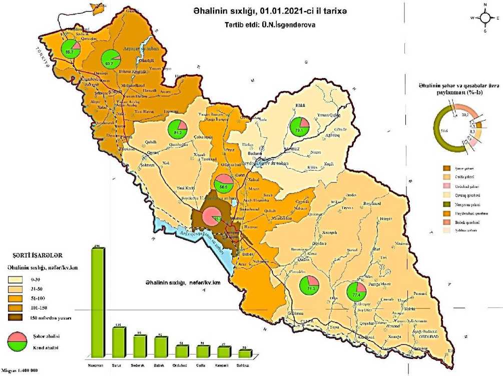
The total land fund of the Nakhchivan Autonomous Republic is 550,275 hectares, and the population is 461,500. 6,4% of the territory and 4,6% of the population of the Azerbaijan Republic belongs to Nakhchivan AR.
The population density is 84 people per 1 km2. The population density varies from region to region. The highest population density in Nakhchivan city is 496 people per 1 km2, 135 in Sharur district, 99 in Sadarak district, 92 in Babek district, 51 in Ordubad district, 51 in Julfa district, 47 in Kangarli district and the lowest in 30 in Shahbuz district [7].
The population density is higher in the foothills and middle mountainous zone. In Nakhchivan AR, the population settled mainly in the areas along the river banks and in the Arazboyu plains. In densely populated areas, anthropogenic impact on soils increases, leading to a decrease in its fertility, resulting in soil degradation. For this reason when studying the problems of land degradation in the autonomous republic the study of population settlement is one of the important issues.
Actuality. Unique environmental problems in modern times are an indicator of global problems. It is difficult to prevent local environmental problems without preventing unique local environmental problems, and it takes many years to solve this problem. Therefore, any problems that may occur must be prevented within the country, in the region or around us.
Land degradation is one of the most dangerous problems facing humanity. Biological reproduction of humans increases the demand for food products that provide it. Human increases the pressure on the soil to meet his needs. As a result, soils lose their fertility, desertification, salinization, swamping, erosion, etc. occur, and as a result, soil degradation begins. Lands are out of production turnover. There are already threats arise to human life. In this regard, the scientific article is devoted to a topical issue.
Coincidence of research work with decisions taken to prevent land degradation, desertification, etc. in the Republic of Azerbaijan, including Nakhchivan AR proves the relevance of scientific research.
Material and method
The article is based on the works of scientists and researchers of the Republic of Azerbaijan on population, data of the State Statistics Committee of the Nakhchivan Autonomous Republic and compiled on the basis of field research materials in 2015-2019 in the research area.
Stationary, diagnostic, cartographic, mathematical statistical methods, field research, systematic analysis, observation, distance learning, internet resources, ArcGIS software were used in the research.
Analysis and discussion
The population of Nakhchivan AR is settled in 6 cities, 9 settlements and 203 villages. In total, there are 218 settlements in the autonomous republic. 163,4 thousand people (35,4%) live in cities and 298,1 thousand people (64,5%) live in rural areas [7].
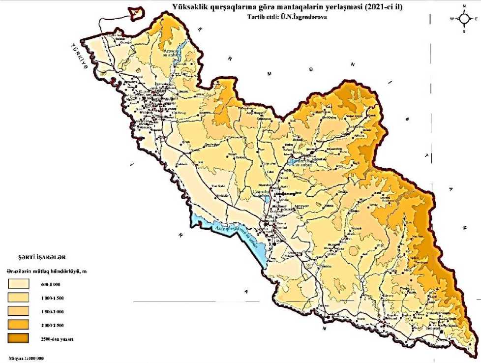
96,7% of the population of city lives at an altitude of 600-1000 m, 3,2% at an altitude of 1000-1500 m, and 0,1% at an altitude of 2000-2500 m. 51,6% of the urban population live in Nakhchivan city, 4,5% in Sharur, 20,2% in Babek, 6,9% in Ordubad, 8,3% in Julfa city, 3,8% in Givrag settlement, 3,3% in Shahbuz city, 1,4% in Heydarabad settlement. The location of the population by altitude is shown on the map below.
The majority of the population in Nakhchivan AR - 67,6% of the rural population and 96,7% of the urban population live in areas with an altitude of 600-1000 m. Nakhchivan, Sharur, Julfa, Babek, Ordubad cities, Heydarabad, Givrag, Nehram, Aliabad, Shahriyar settlements and 111 rural settlements are located within these heights. 55,5% (121 settlements) of the total settlements in the autonomous republic and 75,5% of the population are located within this zone.
Heydarabad settlement, Sadarak and Garaagaj villages located in Sadarak district are situated in Sadarak plain. This means 75% of the total settlements of Sadarak district. The population of the region as a whole is located at an altitude of 600-1000 meters. The population of the region as of January 1, 2021 is 16,100 people [7].
The number of settlements in Sharur district is 66, and the total population is 117,900. 25.5 percent of the population of the Autonomous Republic is located in the Sharur plain, which covers a large part of the Sharur region. The lands of the plain have long been irrigated gray soils and are widely used in agriculture.
The Kangarli sloping Plain, which is part of the sloping plain of Arazboyu, and the arid climate in the Boyukduz have led to the relatively sparse settlement of saline soils. 7 out of 11 settlements of Kangarli region are settled here. The settlements located here contain 63,6% of the total settlements of Kangarli region, and 65,1% of the population (20,486 people).
The Nakhchivan plain covers a large part of the Arazboyu plain. Nakhchivan city, Aliabad settlement, Garakhanbeyli, Garachug, Bulgan, Hajiniyat, Tumbul villages are located in Nakhchivan plain. 85,7% of the population lives here in Nakhchivan city. The Nakhchivan plain is the most densely populated area after the Sharur plain. Most of the population of Julfa region is settled in the Julfa and Yayji sloping plains of the Arazboyu plain.
The territories of the Autonomous Republic with an altitude of 1000-1500 meters covers 30,5% of the total area. Shahbulag, Yukhari Yayji, Hamzali, Akhura and Tananam villages, which make up 7,6% of the total settlements of Sharur district, Karabakh, Chalkhangala, Khinjab,
Tazakend, which cover 36,4% of Kangarli region, 11 settlements, which make up 30,6% of Babek district, 1 city, 1 settlement and 22 villages, which make up about 50% of Shahbuz district, 12 villages, which make up 52,2% of Julfa district, and 17 (36,2%) out of 47 settlements of Ordubad district are located at this height.
The middle mountain belt covering the heights of 1500-2000 meters of the territory of the Autonomous Republic makes up 19,5% of the total area [3]. There are a total of 25 settlements within this zone, which is 11,5% of the total number of settlements. The settlements here are mainly along the river banks and is characterized by a small population. However, there are no settlements in Sadarak and Kangarli districts within this zone.
Areas above 2000 meters in the Autonomous Republic make up 17,1% of the territory. Areas with an altitude of 2000-2500 meters are 9,5%, areas with an altitude of 2500-3000 meters cover 6,1%, and areas above 3000 meters are 1,5%. 10 settlements located at an altitude of 2000-2500 meters in the Autonomous Republic. These settlements are different with small size and small population. 3639 people (0,8%) live in 10 settlements located above 2000 m. There are no settlements in Sadarak, Kangarli and Babek districts within this zone. Havush village in Sharur district (2019 m), 3 settlements in Shahbuz district (Gomur village 2190 m, Bichanak village, 2190 m, Agbulag village), 5 settlements in Ordubad district (Nurgut, Pazmari, Nasirvaz villages, Aghdara 2300 m, Paragachay 2320 m ), and in Julfa district Boyahmed village is within 2038 m of this zone. Paragachay and Agdara settlements of Ordubad region are located in high mountainous. There is no population in Aghdara. Paragachay settlement, located at an altitude of 2320 m and with a population of 87 people, is the highest settlement in the Republic of Azerbaijan [1]. As a result of our analysis and research, we have compiled tables showing the distribution of the population in the autonomous republic by altitude zones and regions, as well as changes in the average annual number (Table 1; 2).
The location of settlements by elevation zones and districts is as shown in the table below (Table 1).
Table 1.
LOCATION OF SETTLEMENTS BY ALTITUDE ZONES AND DISTRICTS
Districts Number of Height zones, meter
|
settlements |
Up to 1000 m |
1000-1500 |
1500-2000 |
2000-2500 |
Above 2500 m |
||||||
|
number |
% |
number |
% |
number |
% |
number |
% |
number |
% |
||
|
Sadarak |
4 |
3 |
75 |
1 |
25 |
- |
- |
- |
- |
- |
- |
|
Sharur |
66 |
59 |
89,4 |
5 |
7,6 |
1 |
1,5 |
1 |
1,5 |
- |
- |
|
Kangarli |
11 |
7 |
63,6 |
4 |
36,4 |
- |
- |
- |
- |
- |
- |
|
Babek |
36 |
22 |
61.1 |
11 |
30.6 |
3 |
8,3 |
- |
- |
- |
- |
|
Shahbuz |
24 |
- |
- |
12 |
50 |
9 |
37,5 |
3 |
12,5 |
- |
- |
|
Julfa |
23 |
6 |
26,1 |
12 |
52,2 |
4 |
17,4 |
1 |
4,3 |
- |
- |
|
Ordubad |
47 |
17 |
36,2 |
17 |
36,2 |
8 |
17,0 |
5 |
10,6 |
- |
- |
|
Nakhchivan |
7 |
7 |
100 |
||||||||
|
Nakhchivan |
218 |
121 |
55,5 |
62 |
28,4 |
25 |
11,5 |
10 |
4,6 |
- |
- |
AR
The territories of Nakhchivan AR with the height of 1000-2000 meters are leading in the republic in terms of the share of the rural population.
Biological reproduction of the population is one of the factors contributing to population growth and land degradation. During the period of independence, population growth has been growing at an increasing rate. In 1995, the natural population growth in Nakhchivan AR had been 21.1 per thousand people. Annual natural growth varied across the area. There were 836 people in Nakhchivan city, 2126 people in Sharur district, 1384 people in Babek district, 403 people in Shahbuz district, 622 people in Ordubad district, 620 people in Julfa district and 199 people in Sadarak district [1].
In 2020, the population growth per thousand people in the Autonomous Republic was 3.8 people, including the annual natural increase of 1753 people, of which 426 people belong to the urban and 1327 people to the rural population. Acceleration of natural growth is an increase in soil pressure. Including 1883 were men and 1828 were women [7].
Table 2.
CHANGE IN THE AVERAGE ANNUAL POPULATION
OF THE NAKHCHIVAN AUTONOMOUS REPUBLIC, THOUSAND PEOPLE
|
Years |
Total population |
Including |
The specific weight of the urban population, % |
The specific weight of the rural population, % |
|
|
urban population |
rural population |
||||
|
2000 |
360.1 |
96.7 |
263.4 |
26.9 |
73.1 |
|
2005 |
380.0 |
111.3 |
268.7 |
29.3 |
70.7 |
|
2010 |
406.3 |
118.1 |
288.2 |
29.1 |
70.9 |
|
2015 |
442.1 |
130.4 |
311.7 |
29.5 |
70.5 |
|
2020 |
459.6 |
135.6 |
324.0 |
29.5 |
70.5 |
Source: Data of the State Statistics Committee of Nakhchivan AR -2020
As of January 1, 2021, the population of the autonomous republic increased by 101,400 people compared to the end of 2000 and amounted to 461,500 people. Using the statistical data we obtained and the capabilities of the ArgGIS program to investigate the problems of population settlement, we have compiled a map of the location (density) of the population in the area.
As a result of our comparisons and analyzes, we have determined that the impact on the soil has intensified and a number of environmental problems have arisen as a result of anthropogenic impacts in the densely populated Arazboyu plains and foothills. The Sharur and Nakhchivan plains, which are mostly inhabited the Arazboyu zone, are almost completely assimilated, and irrigation erosion and re-salinization have become the main problems of the lands, as they are mostly used in agriculture.
Despite the sparse settlement of the population due to the slope and sharp fragmentation of the relief towards the middle and high mountains, the lands are also degraded as a result of natural and anthropogenic influences. Anthropogenic loading of landscapes as a result of overgrazing of summer pastures in high mountainous areas, accumulation of rock fragments on roadsides during construction of roads to high mountain villages, destruction of vegetation in the surrounding areas and destruction of fertile topsoil are among the factors causing soil degradation. In order to prevent environmental problems in the region, it is necessary to regulate the population as needed, strictly follow the irrigation norms to prevent re-salinization and swamping of soils in the plains, strengthen control over the use of collector-drainage networks, it is necessary to follow the norm of use of summer and winter pastures.
References Population density as a major factor causing soil degradation
- География Азербайджанской Республики. В 3 т. Т. II. Экономическая, социальная и политическая география. Баку: Европа, 2015. 328 с.
- Демографические показатели Азербайджана - 2017. Баку: Госкомстат, 2018. 492 с.
- Бабаев С. Ю. География Нахичеванской Автономной Республики. Баку: Элм, 1999. 298 с.
- Эминов З. Н. Население Азербайджана. Баку, 2005. 560 с.
- Гасанов А. М. Природные ресурсы Нахичеванской Автономной Республики и способы их использования. Баку: Элм, 2001. 247 с.
- Ганбарова Г. Г. История расселения и градостроительства в Нахичевани. Т. I. Баку, 2018. 304 с.
- Материалы Госкомстата Нахичеванской АР 2021. Баку.
