Rock Art of the Ana Zaga Cave Shelter in the Archaeological Landscape of Gobustan, Azerbaijan

Author: Farajova M.N.
Journal: Archaeology, Ethnology & Anthropology of Eurasia @journal-aeae-en
Section: Paleoenvironment, the stone age
Article in issue: 4 т.51, 2023.
Free access
The Agisoft and 3D Studio Max software was used to study the petroglyphs of the Ana Zaga rock shelter, the largest in Gobustan. Stylistic features typical of various periods are described, and radiocarbon estimates for various cultural layers are given. Chronological stages in the evolution of rock art are defined. On the basis of geological data concerning transgressions and regressions of the Caspian Sea, the date of the first human settlement of the Ana Zaga shelter is estimated. The species composition of extinct faunas represented in rock art is assessed. It is concluded that in the Neolithic and Chalcolithic, following the rise of the sea level, the rock shelter became the principal habitat. In the Bronze Age, after the sea level had fallen, the middle and lower terraces became suitable for living. As new landscapes were settled, the themes of petroglyphs changed.
Gobustan, Ana Zaga rock shelter, Early Mesolithic, Mount Boyukdash, rock art, AMS-dating, 3D-modeling
Short address: https://sciup.org/145146954
IDR: 145146954 | DOI: 10.17746/1563-0110.2023.51.4.045-054
Text of the scientific article Rock Art of the Ana Zaga Cave Shelter in the Archaeological Landscape of Gobustan, Azerbaijan
Gobustan is a geographical area on a plain between the southeastern slope of the Greater Caucasus Range and the Caspian Sea. Part of the archaeological landscape of Gobustan are rock carvings made at different times on the rocks of the Boyukdash, Kichikdash, and Jinghirdagh mountains. The archaeological complex includes about one thousand sites from different eras—from the Late Upper Paleolithic and Early Mesolithic to the turn of the 18th–19th centuries (Fig. 1). To date, more than 6 thousand rock images, 40 mounds, ca 20 shelter caves, ancient settlements and burials, and about 105 thousand pieces of material culture have been discovered on its territory. Since 1966, Gobustan has been a state historical and artistic reserve. In 2007, the cultural treasures of this site were added to UNESCO World Cultural Heritage List.
The first settlements of Homo Sapiens (Taglar, Damdzhyly, and Yatag Yeri) on the western coast of the Caspian Sea, appeared ~30–35 ka BP (Azərbaycan Arxeologiyası, 2008: 41–42, 44, 53), and the first rock paintings in Gobustan appeared more than 20 thousand years later. The sites of the first settlers of Gobustan (dated to 15 ka BP (Rustamov, 2000: 20)) are concentrated only on the upper terraces (127 m a.s.l.) (Farajova, 2011: 50– 63; 2015b: 220). The petroglyphs on the ancient coast of the Caspian Sea determine the age of the earliest rock art in the region.
The figures executed on stones 29 and 42 (eastern side), as well as on the rocks on the upper terrace of Boyukdash and stone 49 on Kichikdash (eastern side), have both stylistic similarities and differences. The stones are natural walls, and the space between them is the habitat of ancient man, which can be defined as rock shelters or cave shelters.
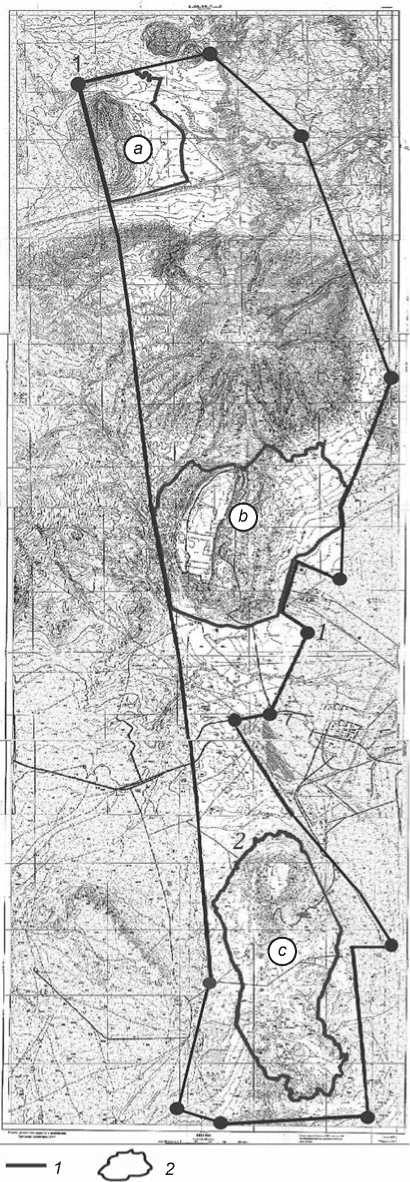
Fig. 1. Map of the Gobustan National Historical and Artistic Reserve.
a – Mount Jingirdag (coordinates 39T 360501 4449820);
b – Mount Boyukdash (39T 361521 4441440); c – Mount Kichikdash (39T 361521 4441440).
1 – boundary of the reserve; 2 – boundary of the archaeological complex of rock art included in the UNESCO World Cultural Heritage List.
The rock art of Gobustan attracts the close attention of scholars: many science and popular-science works are devoted to it, and discussions on the dating and interpretation of individual plots and images continue. Recently, the petroglyphs of Gobustan have been studied using modern digital technologies and computer programs.
The most important problem of dating the Gobustan petroglyphs was raised in the works of the first researchers of the archaeological complex (Jafarzadeh, 1945, 1956, 1957, 1958, 1964, 1965a, b; 1973; Cəfərzadə, 1999; Rustamov, Muradova, 1974, 1975, 1976, 1984, 1986, 2003; Rustamov, 1984, 1986a, b; 1990, 2000, 2003). To determine the absolute age of the images, some experts tried to find stylistically similar analogs among rock paintings from other territories, often very distant (Formozov, 1969, 1980, 1987; Anati, 1994; Huyge, 2009, 2013; Huyge et al., 2011).
For a long time, it was believed that the petroglyphs of Gobustan had already been sufficiently studied (Cəfərzadə, 1999; Rustamov, Muradova, 2003). However, the publication of many new images (Fərəcova, 2007, 2018) led to a renewed focus on the problems of studying rock art in this area, and the use of advanced research methods for archaeological reconstructions, for example, AMS-dating (Farajova, 2011, 2012, 2015a, b, c).
The most significant results were obtained during the study of the multi-layered cave shelter of Ana Zaga, the largest in Gobustan. The surfaces of its stone slabs contain hundreds of overlapping petroglyphs, and in the space between these slabs, in the cultural layers, remains of extinct fauna have been identified.
The aim of this article is to introduce the latest materials—images and compositions identified and studied by the author at the Ana Zaga site, and the results of the analysis using advanced methods of rock-art study, which were unavailable half a century ago, when the main monographs on the topic were published.
Materials and methods
The Ana Zaga cave shelter, formed by almost vertically standing large blocks of limestone up to 15 m high, spaced up to 5 m from each other, is located on the upper terrace of the Boyukdash mountain, at an altitude of ca 130 m a.s.l. The lower layers of the cave, at depths of 5, 6, and 7 m, are composed of the sediments of Pleistocene marine basins.
In the Ana Zaga shelter, cultural layers dating back to the Mesolithic, Neolithic, and Chalcolithic were recorded in the central and southern parts of the human habitation area, at the foot of stone 30 (Аzərbaycan Arxeologiyasi, 2008: 153–156). The cave shelter consists of several chambers, or compartments, between stones with rock images. The first chamber is next to the cave’s entrance, on the left, at the northern side of stone 29. On the southern side of the rock, 26 drawings were identified, and on the northern side, 77. Unfortunately, owing to the lack of appropriate conditions and equipment, the first researchers of the site did not make graphite impressions of some of the petroglyphs (Cəfərzadə, 1999: 201). The use of digital photography and the latest 3D-modeling techniques on stone 29 at Ana Zaga has allowed us to discover new rock images: 79 figures on the northern side, 40 on the eastern side, and 12 on the southern side.
New petroglyphs from various periods were found on the western side of stones 30 and 31. Using the Agisoft software, we were able to record and copy images on this panel, as well as to make estampages of the petroglyphs. The results of radiocarbon studies and the capabilities of the 3D StudioMax software made it possible to classify these petroglyphs by periods.
In 2015, the works on documenting the rock images of Gobustan began, using the Agisoft software and 3D-technologies. Copies of images on the planes of Boyukdash were created in the form of electronic 3D-models: Ana Zaga – stone 29 on the northern, southern, and eastern sides, Oküzler – stone 42 on the eastern and southern sides, as well as stones 65, 68 with figures of aurochs, hunters, and women to the east of Ana Zaga cave; Kichikdash: Gaya-Arasy – stones 9A, 9B, Jeyranlar – stone 49 on the southwestern side, Firuz – stone 19, etc.
In the process of digital documentation, on the northern side of stone 29 at Ana Zaga, a multi-figured composition was revealed: next to female silhouettes, there were previously unrecorded images of boats, aurochs, and hunters. Their photographs were taken with a Nikon 80D SLR camera. The Nikon 80D and Agisoft Photoscan, View MX2, and 3D Studio MAX software were used to obtain a 3D-model. When interpreting various categories of traces, we used the results of our own experimental observations (Ibid.).
To prepare the model, the panel was photographed in parts at a certain angle, and the images were processed in the View NX2 software; photos were converted into JPEG format. On the basis of these photographs, in the Agisoft Photoscan software, a model of the panel with drawings was built.
The experimental use of video technology and “animation” on stone 65 made it possible to identify, using the 3D Studio MAX software, a plot “narration”: women run away from an aurochs, and a man tries to chase the aurochs away.
A detailed study of the Gobustan petroglyphs involves radiocarbon dating of cultural layers where fragments broken off from panels and individual stones with images occur. For this purpose, ca 50 samples from the cave shelters of Ana Zaga, Oküzler, Ovchular, Maral, and Daire on Mount Boyukdash, as well as Gaya-Arasy, Firuz 2 on Mount Kichikdash, were sent to the Laboratory for Radiation-Hygienic Monitoring of the Institute for Hygiene and Medical Ecology of the Academy of Medical Sciences of Ukraine (January 26, 2010), and to the laboratories of the University of Waikato, Hamilton, New Zealand (April 13, 2010, February 23, 2011) and BETA Analytic Inc., Miami, Florida, USA (September 1, 2011, September 23, 2011, July 30, 2014). On the basis of the radiocarbon dating data, rock art was differentiated by periods.
Calibrated dates of 10,430–10,240 cal BP were obtained for the cultural level of –270 cm in the Ana Zaga cave shelter.
To determine the age of the Gobustan petroglyphs, the remains of extinct Upper Pleistocene animals were studied, and geochronological data on the transgressions and regressions of the Caspian Sea were analyzed. Age estimates for bone fossils of animal species such as Bos primigenius boj , Gazella subgutturoza, Equus hemionus Pallas, Sus. scrofa L., Capra aegagrus, Pantera pardus L . from the cultural layers at Ana Zaga allowed us to determine the approximate date of some rock images.
According to the results of radiocarbon dating, the beginning of the Khvalynsk transgression dates back to the Terminal Late Pleistocene (almost 15–12 ka BP), and the end, to the Initial Holocene (9–7 ka BP), which coincides with the last glaciation (late stage of the Valdai glaciation, late stage of the Würm glaciation) of the East European Plain, as well as with the low level of the World Ocean, which was 25 m below the level of the modern sea (Svitoch, 2006: 22). The flourishing of the Gobustan rock art falls precisely within this period.
According to geochronological data, 14 ka BP, the level of the Caspian Sea was 22 m higher than the modern one (Arslanov et al., 2016); 14–12 ka BP, sea level ranged from 0 to -12 m (the modern sea level is 27 m, so the sea was higher by 27 and 15 m); 10 ka BP, a transgression occurred; 8 ka BP, the New Caspian regression began (Mamedov, 1997); 6 ka BP, sea level rose again by 25 m; 4 ka BP, by 23 m; 4–2 ka BP, a regression has begun (The Black Sea…, 2007: 144); 17 centuries ago, a major transgression happened owing to rapid warming, which caused the melting of continental ice and permafrost, as well as excessive flooding in river valleys; the level of the Caspian Sea rose so much that water cascaded onto the low-lying lands (Svitoch, 2006). As the sea receded, rocks were exposed, and the ancient inhabitants of the Caspian region began to create petroglyphs, first on the upper and then also on the lower terraces. Already 10 ka BP, when a major transgression occurred, the Ana Zaga cave shelter was the habitat of humans who left the first images on the walls.
The figures on the Ana Zaga walls (stones 29, 32, 39) correspond, both in style and application technique, to the images on the stones deposited in cultural layers. In 1977, in Ana Zaga Cave, at a depth of 255–270 cm, a piece of rock with petroglyphs was discovered (State National Historical and Artistic Reserve (GNIHZ), Inv. No. 2418) (for sediments at this depth, there is a calibrated radiocarbon date of 7500–7420 cal BP). On the edge of the rock, part of an anthropomorphic image carved in deep relief is visible. Hunters on stones 29 (northwestern side, figures 4, 5, 56, 57), 33 (figure 20) and 35 (figures 2, 3) were depicted in the same technique and stylistic manner. These figures are identical to those of hunters shown on a separate stone discovered at a depth of 255–265 cm at the Kyaniza site (GNIHZ, Inv. No. 1479), on stone 42 (northern side, figure 9), and on stone 68 on the upper terrace of Mount Boyukdash, as well as at the Jeyranlar site.
Research results
Among the Early Mesolithic petroglyphs on the northern side of stone 29 at Ana Zaga, images of aurochs at actual size predominate. The most ancient of them are probably associated with totemic beliefs. The cult of the aurochs was reflected in the epic of the Turkic-speaking Oghuz tribes. Images of aurochs are often accompanied by female figures in profile.
The aurochs depicted on the rocks of Gobustan is most often associated with the aurochs Bos primigenius boj . Some images of aurochs bear indentations—traces of magical actions performed by ancient people to ensure good luck in the hunt. The cult significance of this animal is evidenced by aurochs figurines deposited in cultural layers of various settlements on the territory of Azerbaijan. Several such artifacts were discovered in the lower layers of the Kura-Araxes culture at one of the ancient settlements in Geytepe (ismayilova, 2006).
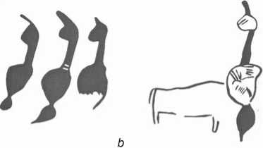
Female figures hold a special place in the repertoire of petroglyphs on the walls of the Ana Zaga cave shelter. Female images are among the most attractive in the rock art of Gobustan. Claviform female representations carved in deep relief on the northern side of stone 29 (Fig. 2; 3, 53 , 54 , 59–69 , 71–77 , 113 , 114 ) belong mainly to the early period. Many of the figures obviously represent the image of a pregnant woman. Most often, such images occur in combination with a separate life-size figure of an aurochs. Female silhouettes and the figure of an aurochs (Fig. 4), depicted on stone 29A, as well as numerous images of boats and other characters made on the northern side of
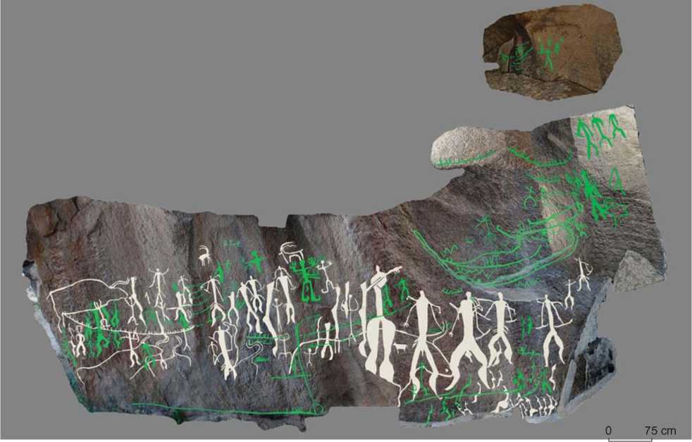
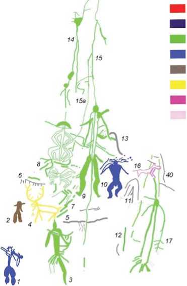
Fig. 2. Images (3D photography) on stone 29 (northern side) at Ana Zaga Cave (Farajova, 2016). Petroglyphs discovered by the author are highlighted in green.
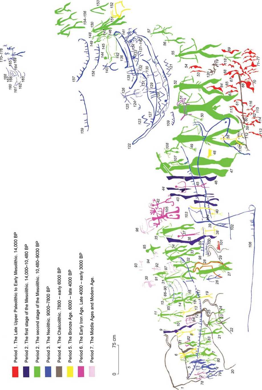
Fig. 3 . Graphic trace-drawing of the images on stone 29 (northern side) at Ana Zaga Cave (Farajova, 2016).
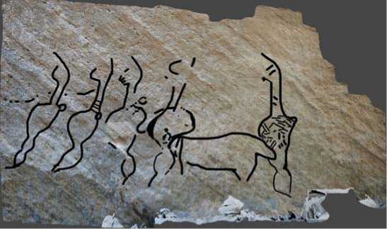
Fig. 4 . Images on stone 29A at Ana Zaga Cave.
a – 3D photograph (Farajova, 2016); b – print by J. Rustamov (Rüstəmov, 2006); c – composition with a figure identified by the author ( 6 ) (Farajova, 2016).
stone 29 (see Fig. 3, 109 , 122–141 ), harmonize with each other and form unified plots.
In the Late Mesolithic/Early Neolithic, the female image in petroglyphs changes—it begins to be conveyed in an increasingly schematic form. Some figures resemble Chalcolithic terracotta figurines from Gargalar Tepesi and Shulaverisgor (Central Transcaucasus). The women are depicted without heads and arms, in a semisitting position. Archaeologists associate the female figurine from Shulaverisgor with the idea of fertility (Fərəcova, 2009: 222–223). In Azerbaijan, images of women are found only in the southeastern part—in Gobustan. In other places of the periglacial zone of the country, no Stone Age rock art depicting human figures has been found.
A slightly different style is represented by life-size images of women with massive corpulent thighs, without arms, or with schematically rendered arms and legs, with prominent breasts and a large saggy belly (see Fig. 3, 28 ). Such a figure, covered by images of hunters, is depicted in the lowest part of stone 29. The figure of a pregnant woman, in the upper area of its abdomen and chest, is covered with a zigzag or scaly ornament. On the same stone, another, probably female, figure with the same decoration was discovered (see Fig. 3, 103 ). Both figures have lost their lower torsos owing to stone erosion.
Similar female figures are carved on the eastern side of stone 42 in Oküzler Cave. Of particular interest are the images of women at actual size on stone 29A in the southeastern sector of Ana Zaga Cave, which is considered one of the oldest human habitats in Gobustan. At this stone, the images of four women and one aurochs were recorded. And we were able to discover another life-size image of a woman. Thus, a whole composition is presented here, including the figures of four pregnant women following each other, and a separate tattooed woman. The latter covers the barely visible contours of the aurochs. The tattooed figures of Gobustan find parallels with similarly interpreted characters of Trypillian culture (Rybakov, 1981: 179, 189).
It can be assumed that in the earliest period, as symbols of fertility, heavy mature women with saggy bellies were depicted on the rocks, and at a later period, pregnant women (Ibid.: 189). The same semantic meaning have clay female figurines of naked goddesses found in the ancient settlements and necropolises of Mollaisakli, Mingachevir, Shamakhi, and Kabala. The waists of the goddesses are intercepted by belts, and their necks are decorated with several rows of necklaces (Fərəcova, 2009: 223).
It is quite likely that the most ancient means of transportation for the inhabitants of Gobustan were boats depicted 7800 years ago, which could accommodate more than 50 people. For the reconstruction of cultural-historical processes and spiritual-magical ideas of ancient hunter-gatherers on the territory of Azerbaijan, particularly Gobustan, the petroglyphs on the southern side of stone 29 on the upper terrace of Mount Boyukdash are very important. Of particular interest is the plot with boats, and hunters armed with bows and arrows. The use of 3D-modeling technologies has made it possible to discover 38 new images on this stone. I. Jafarzadeh recorded 20 images on the southern side of stone 29, and D. Rustamov, another 26 images, including two anthropomorphic figures and some indeterminate lines and marks under the image of a boat.
In 2007, we identified poorly-preserved figures of an aurochs, an anthropomorphic figure, and a fragment of a boat image (previously identified as a zoomorphic figure). The image of a boat crosses the anthropomorphic figure.
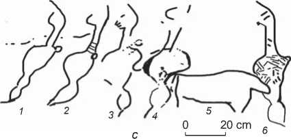
On the eastern side of stone 29, a complex composition is presented. 40 new images have been identified here:
9 anthropomorphic and 5 zoomorphic figures, 10 boats, 2 lines with cup-like depressions, and unidentifiable figures. Noteworthy are lines 14, 15, and 15a (Fig. 5), extending from cup-like depressions at the top of the rock. They split in two, pass through the figures of hunters 9 and 8, and, having come into contact with the
а
Period 1. The Late Upper Paleolithic to Early Mesolithic. 14,000 BP
Period 2. The first stage of the Mesolithic. 14,000-10,480 BP
Period 2. The second stage of the Mesolithic. 10,480-9030 BP
Period 3. The Neolithic. 9000-7800 BP
Period 4. The Chalcolithic. 7800 - early 6000 BP
Period 5. The Bronze Age. 6000 - late 4000 BP
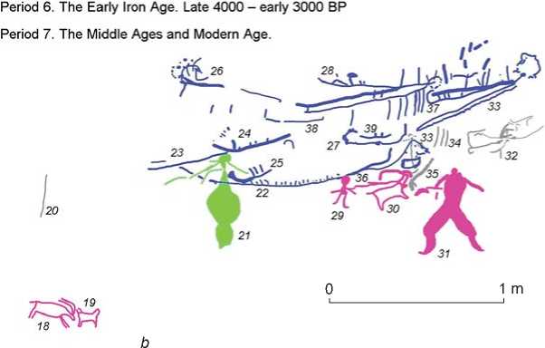
Fig. 5. Images on stone 29 (eastern side) at Ana Zaga Cave (Farajova, 2016). a – 3D photography; b – graphic trace-drawing.
genital organs of the anthropomorphic characters, go down to the ground. Line 15a connects with the multitiered zigzag figure 8 at the level of the shoulder or elbow (?). Line 14 originates at the very top of the rock with a cup-shaped depression, passes through two other depressions, located one below the other, and through the mushroom-shaped decoration of multi-tiered figure 8 (Fig. 5). This figure connects with the lines extending from the cup-like depressions. A special feature of figure 8 is its mushroom-shaped headdress. Images of anthropomorphic characters in mushroom-shaped headdresses are widespread in the rock art of Mongolia, Altai, and Tuva (Devlet E.G., Devlet M.A., 2011: 79–80). Figure 8 is shown probably in ritual clothing or in a state of trance. Hunters 3, 9, 17 are depicted at actual size on the southeastern side of stone 29.
Conclusions
The uniqueness of the Gobustan archaeological complex lies in the fact that the cultural layers of its sites near the rocks with petroglyphs contain stones with their images identical to those presented on the caves’ walls. Absolute dates obtained for the cultural layer where stones with petroglyphs were discovered suggest the age of the images on the walls of these cave shelters. If petroglyphs are associated with an archaeological layer, then their age can be determined quite accurately: rock carvings precede or are contemporaneous with this layer. A wide variety of data is taken into account when attributing the age of petroglyphs, such as style, imaging technique, and radiocarbon dating results.
Among the radiocarbon dates obtained for Gobustan, the oldest is ca 13,610 cal BP, corresponding to the Gayaarasy rock shelter (-350 cm) on Mount Kichikdash (Farajova, 2012, 2016, 2018a, b, c, 2021). The next oldest date is ca 10,600 cal BP, obtained for the cultural layer (-270 cm) of Ana Zaga Cave on Mount Boyukdash. Considering the fact that 14 thousand years ago the Late Khvalynian transgression occurred and the Khvalynian Sea waters washed the Boyukdash, Kichikdash, and Jingirdag mountains, the interval between these dates could have been due to the sea level rise.
Thus, the cumulative data suggest the following periods and stages in the rock art of Gobustan.
Period I. The Late Upper Paleolithic to Early Mesolithic. The most ancient period. 14,000 BP (12th millennium BC).
Period II. The Epipaleolithic to Mesolithic. 14,000– 9030 BP (12th–8th millennia BC).
Stage I. Late 14,000 to 10,480 BP (12th–9th millennia BC).
Stage II. 10,480–9030 BP (9th–8th millennia BC).
Period III. The Neolithic. 9000–7800 BP (7th– 6th millennia BC).
Period IV. The Chalcolithic. 7000–6000 BP (6th to the first half of the 4th millennia BC).
Period V. The Bronze Age. 4th to late 2nd millennia BC.
Period VI. The Early Iron Age. Late 2nd to early 1st millennia BC.
Period VII. The Middle Ages and Modern Age.
In the Late Upper Paleolithic to Early Mesolithic, settlements were most often located on the upper terraces. At such a height, the inhabitants of the caves could feel safe and control the surrounding areas. In the Neolithic and Chalcolithic, with the rise of the Caspian Sea’s level, the Ana Zaga cave shelter was still a human habitat. In the Bronze Age, as sea level had fallen, the middle and lower coastal terraces also became populated. The themes of petroglyphs changed. During this period, the inhabitants of Gobustan, who were engaged in cattle breeding, depicted bezoar goats with large, curved horns. At the foot of the mountains, settlements circular in plan view appeared, and a tradition of burying the dead in mounds was developed.
Judging by the radiocarbon dating results, the Ana Zaga images can be divided into the following chronological groups: 1560 ± 55 BP; 4950 ± 200 to 5940 ± 40 BP (6880–6670 cal BP) to 6530 ± 40 BP (7500–7420 cal BP); 8670 ± 40 BP (9700–9540 cal BP) to 8996 ± 33 BP; 9170 ± 40 BP (10,480–10,460 cal BP).
These findings allow the conclusion to be made that in Ana Zaga Cave, whose walls contain more than 500 rock carvings, people lived for a very long time— from the Early Mesolithic to the Middle Ages.
