Spatial structures of the initial/early Upper Paleolithic at Tolbor-21, Northern Mongolia

Author: Marchenko D.V., Khatsenovich A.M., Bolorbat T., Gunchinsuren B., Zwyns N., Paine C., Rybin E.P.
Journal: Archaeology, Ethnology & Anthropology of Eurasia @journal-aeae-en
Article in issue: 3 т.51, 2023.
Free access
This article describes the spatial structures of archaeological horizon 4 at Tolbor-21 in northern Mongolia, on the basis of data from 2015–2017. The presence of non-utilitarian items, faunal remains with traces of human impact, and the use of fi re render this site near outcrops of raw materials promising for the reconstruction of the spatial organization of Early Upper Paleolithic sites in northern Mongolia. Spatial analysis included visual observations and statistical procedures (clustering with two algorithms) aimed at identifying patterns in the distribution of fi nds in various areas. The infl uence of natural processes on the distribution of artifacts was evaluated with fabric analysis based on the positions of the long axes of fi nds. As a result, it was found that solifl uction variously affected the archaeological horizon in different parts of the slope. The effect was strongest in excavation 2, where two possibly overlapping episodes of fi rerelated activity have been reconstructed. Nevertheless, it is possible to separate two complexes differing in terms of fi nds, including signifi cantly modifi ed tools and bones with traces of human impact (“fi replace 1”) and a concentration of small artifacts (“fi replace 2”). In the upper part of the slope (excavation 4), near the stone structure, an accumulation of cores at the advanced reduction stages is reconstructed, as well as an area where ungulate carcasses were butchered. An area associated with primary reduction has been separated in excavation 1. The differential use of the camp area by its inhabitants seems to be an important feature of the subsistence strategy of the population of northern Mongolia during the initial stages of the Upper Paleolithic.
Northern mongolia, initial upper paleolithic, early upper paleolithic, spatial analysis, fabric analysis, spatial clusterization
Short address: https://sciup.org/145146923
IDR: 145146923 | DOI: 10.17746/1563-0110.2023.51.3.059-066
Text of the scientific article Spatial structures of the initial/early Upper Paleolithic at Tolbor-21, Northern Mongolia
Archaeological data derived from the open-air sites in northern Mongolia (Tolbor-4, -16 and -21, Kharganyn-Gol-5) indicate that this area was inhabited by the humans producing the lithic industries of the initial stages of the Upper Paleolithic (Derevianko et al., 2013; Khatsenovich et al., 2017; Zwyns et al., 2019; Rybin et al., 2020). Dozens of sites along the Tolbor and Kharganyn-Gol rivers (tributaries of the Selenga River) share such common features as the proximity of outcrops of silicites suitable for making tools and the geomorphological position on the gentle slopes of southern exposure (Rybin, 2020: 129). Similar environmental features raise the question of identification of the subsistence strategy of the ancient population of the region. Along with the proximity to the outcrops of raw materials, the presence of nonutilitarian items, well-prepared tools, and traces of the use of fire (Rybin, 2020: 141, 169; Khatsenovich et al., 2017; Gallo et al., 2021) suggests a more complex organization of sites rather than workshops.
Spatial analysis of the sites of the Tolbor group is hampered by the noted features of disturbances of archaeological horizons. Deposits were formed on gentle slopes under the conditions of low sedimentation rate and high soil acidity, and were often affected by solifluction and diluvial-proluvial processes (Kolomiets et al., 2009; Zwyns et al., 2019; Rybin et al., 2020; Gallo et al., 2021). This paper presents the analysis of the spatial distribution of artifacts within archaeological horizon 4 (hereinafter AH4) at Tolbor-21. The influence of the natural processes on the distribution of artifacts, as well as the patterns of the ancient human behavior, have been assessed through statistical methods.
Materials and methods
The multi-layered site of Tolbor-21 is located in the middle reaches of the Tolbor River (49.26306 N, 102.95778 E), at an altitude of 1089 m above sea level (Fig. 1). The site was discovered in 2011 (Tabarev et al., 2012); excavations have been ongoing since 2014. We examined materials from excavation 1 (hereinafter E1) in the medial part of the slope, and excavations 2 and 4 (E2 and E4) at the eastern side of the slope (Fig. 1); the analysis of the artifact collections from these excavations have been completed (2015–2017).
Archaeological horizon 4 (AH4) was identified within a layer of laminar loess-like deposits over the entire area of the site (Fig. 2). The calibrated radiocarbon dates obtained on collagen from bones from various parts of the layer are in the range of 42.4– 41.9 ka BP (OxCal 4.4, IntCal20) (Rybin et al., 2020). The lithic industry, aimed at the production of large and medium blades, included the tools marking the Initial Upper Paleolithic and belonged to the boundary between its initial and early stages (Rybin, 2020: 149–159). The faunal materials represent steppe biota (Rybin et al., 2019).
The study of the state of preservation of the archaeological horizon included, apart from geological data, the assessment of the orientation of the long axes of the finds (lithic artifacts and bones) using “fabric analysis” (Bertran, Texier, 1995), which was carried out with R code by S. McPherron (2018) in the R core software (R Core Team, 2023).
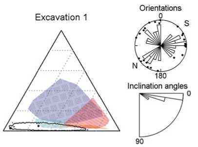
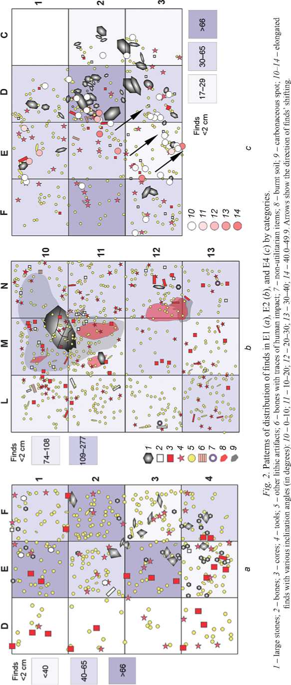
For spatial analysis, the finds were subdivided into seven categories (see Table ). Target (blanks) and non-target spalls were distinguished by metric features with respect to the basic specifics of the spall assemblage (Rybin, 2020: 153–157, tab. 83–85). The tools were classified according to the degree of modification, taking into account two parameters: 1) length of the margins processed with retouch; 2) degree of modification of the primary area: minor (facets occupy <2 mm from the edge), moderate (2–4 mm), and heavy (>4 mm) (Kolobova, 2004: 37–39). This classification served as the basis for establishing groups of tools according to their degree of surface modification through secondary working: from minor to heavy. The analysis was based on two clustering algorithms. The clustering tendency of the finds was tested through Hopkins statistic, which determines the measure of their spatial randomness (Adolfsson, Ackerman, Brownstein, 2019). The k-means method was used to establish the distribution patterns (Kintigh, Ammerman, 1982). The “unconstrained clustering” algorithm (Whallon, 1984) identifies adjacent grids with similar proportions of artifact categories. The significance is tested through an estimate of the probability of formation of a cluster of the same size in random data.
Results
The analysis of the geological structure of the profiles revealed traces of solifluction in the deposits at all the three excavations (Rybin et al., 2020). The analysis of orientations of AH4 (see Fig. 1) in E1 showed no post-depositional disturbances: there is no dominant
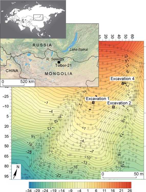
Fig. 1. Location of Tolbor-21, local topography (by V.M. Kharevich and G.D. Pavlenok), location of the excavation areas, and the results of the fabric analysis of mudflow ( 1 ), small flow ( 2 ), solifluction ( 3 ), and steep flow ( 4 ).


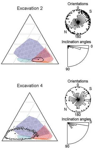
orientation of the elongated finds; the median angle of the artifacts’ inclination is consistent with the general inclination of the horizon. In E2, the impact of solifluction is evident. In E4, the suspended position of the finds in the profile indicates a significant effect of slope processes. Shifting is also traced in the form of a line of elongated artifacts with large angles of inclination (D2, E2, E3), stretching across the slope (see Fig. 2, c ).
The spatial analysis showed a low density of finds and no tendency for their clustering in E1 (see Table). The “unconstrained clustering” algorithm revealed a homogeneous composition of the finds (cluster I, p = 0.02). The different composition of the finds along the D-line is probably explained by the less detailed recording in this plot, without a tachymeter (Fig. 3, a).
In E2, the density of solitary finds is 3 times higher and the density of small (<2 cm) artifacts is more than 5 times higher than in E1 and E4 (see Table ). Two complexes of traces of burning have been distinguished here: a layer of sandy loam with charcoal lenses of a total thickness of 5–10 cm, and a thin (≈1 cm) calcined layer. The former layer is located lower on the slope— in grids N12 and M11, the latter upper layer—in grids M10, M11, N10 (see Fig. 2, b ). The above dates have been generated on the bones located at the borders of these complexes, along with other things, which indicates a narrow chronological range for their use.
|
ф |
со о |
со о |
со о |
|
|
СЛ p (Z) t ro |
о СМ |
со Е О fcco |
со in со |
CD in in |
О О O' >> ti 5 (Л
0^0 |
in w см |
со in in со |
СО со см см |
|
|
w ro |
Е, |
см |
см |
см |
|
E c ft о |
0s |
о о |
о о |
о о |
|
ГО ё |
in in см |
см о |
см |
|
|
СЛ о |
0s |
со |
со ft |
о см со |
|
ГО ё |
ю |
|||
|
w о |
0s |
к со |
со со см |
со |
|
ГО £ |
||||
|
in со |
о со |
со со |
||
|
го (Л CD |
0s |
о со CD см |
CD со см |
см см со |
|
ГО ё |
со |
CD со см |
со со |
|
|
(Л ^ Z |
0s |
in см со |
ft |
3 со см |
|
ГО ё |
in CD |
со |
||
|
CD р Ь Е о ф О |
0s |
со со со |
о |
со |
|
ГО £ |
см см |
о |
со со |
|
|
(Л ф CL |
0s |
со CD |
со ft |
см ft |
|
ГО ё |
in |
in |
||
|
(Л £ О О |
0s |
со со |
S см |
со CD cd |
|
ГО |
||||
|
со см |
CD |
|||
|
с о го го ш |
ш |
см |
ш |
|
Note. H values around 0.5 imply an even distribution of data; H < 0.3 indicates the tendency towards clusterization of data.
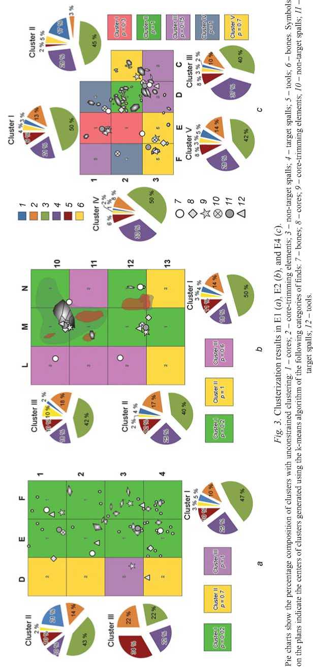
No trend towards clustering of the finds has been noted in E2 (see Table ); k-means clustering did not reveal any differences in the distribution of artifact categories: the centers of clusters of most categories coincide (see Fig. 3, b ).
In E4, a stone structure, including two elongated stones (lying perpendicular to one another) and several smaller stones, has been recorded (see Fig. 2, c , sq. D2). Given a low density of finds (see Table ), artifacts and a few bones are grouped near the stone concentration. The analysis showed that four of the five found ungulate bones bearing traces of human impact were concentrated at the fireplace. The most common type of impact is indentations resulting from bone-breaking in order to extract bone marrow and fat; these traces suggest a butchering zone here (Rybin et al., 2019). Clustering by category showed that only cores formed a cluster centered in sq. D2 (see Fig. 3, c ). Eleven out of 24 cores in E4 were concentrated near the stone structure.
Discussion
The analysis of the state of preservation of the archaeological horizon has shown that solifluction was the dominant process, but the degree of its effect on the distribution of artifacts, orientations, and angles of inclination of elongated artifacts is different in different parts of the solifluction lobe (Nelson, 1985; Bertran, Texier, 1995). The various states of preservation of AH4 depend on the position of the excavations in the frontal (E2) or middle/distal (E1) part of the solifluction “tongue”.
Excavation 2 did not reveal any clear spatial structure, which fact could be explained by solifluction, or by the overlapping of traces of several episodes of human habitation. The high concentration of finds and the overlapping of one complex of traces of burning by another testify to a palimpsest, which is an obstacle to deciphering the distribution pattern (Leonova, 1994: 132). Solifluction could have caused the deformation of the original spatial distribution of the finds; however, some accumulations cannot be explained by this process (concentration of bones in sq. M11, N11, tools in sq. L10; see Fig. 2, a). In addition, the traces of burning, although deformed, retain their internal structure (carbonaceous interlayer and calcination). Therefore, we assume that spatial structures associated with the use of fire were not destroyed by solifluction. Taking into account the small area of the overlapping traces of burning (line 11), these complexes can be distinguished. The upper one (“fireplace 1”) includes the bulk of the finds from sq. L–N/10–11, with a concentration of bones and tools, including heavily modified artifacts; the lower complex (“fireplace 2”) includes most of the finds from sq. L–N/12–13, with a significant proportion of small artifacts and bones.
In E4, despite the fact that the artifacts might have been concentrated at the stone structure owing to slope shifting, the composition of the assemblage indicates an anthropogenic origin. An accumulation of bones with butchering marks and cores among natural blocks of raw materials, showing signs of pre-testing and discarded in situ , a small number of core-trimming elements and crust-retaining flakes (most pieces have no crust, several specimens have it on only 40 % of the surface, and only one retains the crust over 90 % of the surface), as well as tools, distinguishes this plot from the rest of the E4 area. Thus, the stone structure was a storage place for the prepared cores, which were partially knapped outside. The concentration of ungulate bones with traces of butchering (Rybin et al., 2019) suggests subsistence activities.
Comparison of cores by the areas retaining natural crust on the flaking-surfaces has shown that in E4 the proportion of cores at the initial reduction stages is higher than in other excavations. In E1, cores show various stages of reduction; 15 % of spalls (including tools) retain >40 % of crust (greater than in E2 and E4), and spalls without crust make up the smallest percentage as compared to other excavations. In E2, cores at the terminal reduction stages account for the largest share (46 % of cores without crust on the flaking surface); the share of spalls without crust is larger (71 %) than in other areas. The intensity of stone reduction (Rybin, 2020) in E2 is the lowest: six unretouched spalls per tool (8:1 and 10.4:1 in E1 and E4, respectively).
Thus, Tolbor-21 shows an example of the evident zoning of the site and implies the prospects of spatial investigation of the Tolbor sites. Owing to the poor conditions of preservation, these studies are quite few now; but the available data indicate traces of spatial organization also at other sites of the region (Tolbor-15 (Khatsenovich et al., 2015), Tolbor-4 (Marchenko, Rybin, Khatsenovich, 2020)). The southern part of Western Transbaikalia, connected with northern Mongolia through a passageway along the Selenga valley, reveals a similar development of material culture (Rybin, 2020: 372); this area seems to be promising in terms of searching the parallels in the spatial organization of ancient sites. At the Transbaikalian sites of the initial and early Upper Paleolithic, researchers have described accumulations of stone tools and bones, hearths of various designs, stone structures, and buried household objects (Konstantinov, 1994: 49–50; Lbova, 2000: 46–47, 107; Tashak, 2016: 48–70).
Conclusions
As a result of the study, a differentiated effect of solifluction was revealed in various parts of the Tolbor-21 site. Spatial analysis showed zones of different activities in AH4. E1 is the area with spatially unstructured traces of core reduction. E2 is a continuous accumulation of artifacts, deformed by solifluction, yet showing traces of burning, partially overlapping one another. In the upper part of the slope (E4), closer to the rocky outcrops, the activity was arranged around a small stone structure, which was probably used to store cores at the advanced reduction stages and associated with the butchering of animal carcasses. The involvement of a wider range of methods, primarily traceological analysis, will make it possible to clarify the functional specifics of the selected areas.
The differential use of the area seems be an important feature of the organization of activities at the sites near the outcrops of raw materials. Separation of production zones (E1) from economic ones associated with heating and, probably, food consumption (E2), as well as zone for butchering and storing prepared cores (E4), suggests a developed subsistence strategy of the population producing the Initial/Early Upper Paleolithic industry in northern Mongolia; this strategy was adapted to the conditions of raw material delivery and availability of game animals.
Acknowledgements
References Spatial structures of the initial/early Upper Paleolithic at Tolbor-21, Northern Mongolia
- Adolfsson A., Ackerman M., Brownstein N.C. 2019 To cluster, or not to cluster: An analysis of clusterability methods. Pattern Recognition, vol. 88: 13–26.
- Bertran P., Texier J.-P. 1995 Fabric analysis: Application to Paleolithic sites. Journal of Archaeological Science, vol. 22: 521–535.
- Derevianko A.P., Rybin E.P., Gladyshev S.A., Gunchinsuren B., Tsybankov A.A., Olsen J.W. 2013 Early Upper Paleolithic stone tool technologies of Northern Mongolia. The case of Tolbor-4 and Tolbor-15). Archaeology, Ethnology and Anthropology of Eurasia, No. 4: 21–37.
- Gallo G., Fyhrie M., Paine C., Ushakov S.V., Izuho M., Gunchinsuren B., Zwyns N., Navrotsky A. 2021 Characterization of structural changes in modern and archaeological burnt bone: Implications for differential preservation bias. PLoS ONE, vol. 16 (7). Art. No. e0254529.
- Khatsenovich A.M., Rybin E.P., Gunchinsuren B., Olsen J.W. 2015 Kostrishcha stoyanki Tolbor-15: Planigrafi ya poseleniya i deyatelnost cheloveka v ranney stadii verkhnego paleolita Mongolii. Vestnik Novosibirskogo gosudarstvennogo universiteta. Ser.: Istoriya. Filologiya, vol. 14 (7): 38–49.
- Khatsenovich A.M., Rybin E.P., Zotkina L.V., Gunchinsuren B., Bolorbat T., Odsuren D., Olsen J.W., Shelepaev R.A., Popov A.Y. 2017 New evidence for Paleolithic human behavior in Mongolia: The Kharganyn Gol 5 site. Quaternary International, vol. 442: 78–94.
- Kintigh K.W., Ammerman A.J. 1982 Heuristic approaches to spatial analysis in archaeology. American Antiquity, vol. 47: 31–63.
- Kolobova K.A. 2004 Priyemy oformleniya kamennykh orudiy v paleoliticheskikh industriyakh Gornogo Altaya. Novosibirsk: Izd IAET SO RAN.
- Kolomiets V.L., Gladyshev S.A., Bezrukova E.V., Rybin E.P., Letunova P.P., Abzaeva A.A. 2009 Environment and human behavior in Northern Mongolia during the Upper Pleistocene. Archaeology, Ethnology and Anthropology of Eurasia, No. 1: 2–14.
- Konstantinov M.V. 1994 Kamenniy vek vostochnogo regiona Baikalskoy Azii: K Vsemirnomu arkheologicheskomu inter-kongressu (Zabaikalye, 1996). Ulan-Ude: Izd. BION BNC SO RAN, Chita: Chit. Gos. Ped. Inst.
- Lbova L.V. 2000 Paleolit severnoy zony Zapadnogo Zabaikalya. Ulan-Ude: Izd. BNC SO RAN.
- Leonova N.B. 1994 Sovremennoye paleolitovedeniye: Metodologiya, kontseptsii, podkhody: D. Sc. (History) Dissertation. Moscow.
- Marchenko D.V., Rybin E.P., Khatsenovich A.M. 2020 Izucheniye prostranstvennogo zonirovaniya kamennykh artefaktov na stoyanke Tolbor-4 (Severnaya Mongoliya) v fi nale MIS-3 posredstvom klasternogo analiza. Teoriya i praktika arkheologicheskikh issledovaniy, No. 2: 128–137.
- McPherron S.J.P. 2018 Additional statistical and graphical methods for analyzing site formation processes using artifact orientations. PLoS ONE, vol. 13 (1). Art. No. e0190195.
- Nelson F.E. 1985 A preliminary investigation of solifl uction macrofabrics. Catena, vol. 12: 23–33.
- R Core Team. 2023 R: A language and environment for statistical computing. URL: https://www.R-project.org/ (Accessed February 20, 2023).
- Rybin E.P. 2020 Regionalnaya variabelnost kamennykh industriy nachala verkhnego paleolita v Yuzhnoy Sibiri i vostochnoy chasti Tsentralnoy Azii: D. Sc. (History) Dissertation. Novosibirsk.
- Rybin E.P., Klementiev A.M., Rendu W., Khatsenovich A.M., Marchenko D.V., Gunchinsuren B. 2019 Faunisticheskiy nabor i planigraficheskaya struktura stoyanki nachalnogo verkhnego paleolita v Severnoy Mongolii (Tolbor-21). In Problemy arkheologii, etnografi i, antropologii Sibiri i sopredelnykh territoriy, vol. XXV. Novosibirsk: Izd. IAET SO RAN, pp. 231–237.
- Rybin E.P., Paine C.H., Khatsenovich A.M., Tsedendorj B., Talamo S., Marchenko D.V., Rendu W., Klementiev A.M., Odsuren D., Gillam J.C., Gunchinsuren B., Zwyns N. 2020 A new Upper Paleolithic occupation at the site of Tolbor-21 (Mongolia): Site formation, human behaviour and implications for the regional sequence. Quaternary International, vol. 559: 133–149.
- Tabarev A.V., Gunchinsuren B., Gillam J.C., Gladyshev S.A., Dogandjic T., Zwyn N., Bolorbat C., Odsuren D. 2012 Kompleks pamyatnikov kamennogo veka v doline r. Ikh-Tulberijn-gol, Severnaya Mongoliya. Arkheologiyn sudlal, vol. XXX: 51–64.
- Tashak V.I. 2016 Vostochniy kompleks paleoliticheskogo poseleniya Podzvonkaya v Zapadnom Zabaikalye. Irkutsk: Izd. Inst. Geografi i im. V.B. Sochavy SO RAN.
- Whallon R. 1984 Unconstrained clustering for the analysis of spatial distributions in archaeology. In Intrasite Spatial Analysis in Archaeology. Cambridge: Cambridge Univ. Press, pp. 242–277.
- Zwyns N., Paine C., Bolorbat T., Talamo S., Fitzsimmons K., Gantumur A., Guunii L., Davakhuu O., Flas D., Dogandzic T., Doerschner N., Welker F., Gillam J.C., Noyer J.B., Bakhtiary R.S., Allshouse A.F., Smith K.N., Khatsenovich A.M., Rybin E.P., Gunchinsuren B., Hublin J.-J. 2019 The northern route for human dispersal in Central and Northeast Asia: New evidence from the site of Tolbor-16, Mongolia. Scientifi c Reports, vol. 9 (1). Art. No. 11759.
