The 50th Anniversary of the Start of Drilling the Kola Superdeep Well

Author: Lobanov K.V., Chicherov M.V., Sharov N.V.
Journal: Arctic and North @arctic-and-north
Section: Reviews and reports
Article in issue: 44, 2021.
Free access
The Kola Superdeep Well (SG-3) is an outstanding achievement of Soviet science and technology, drilled in Precambrian crystalline rocks and reached a depth of 12262 m. It was one of a series of super deep wells planned within the framework of the program “Earth's Interior Exploration and Superdeep Drilling”. In order to achieve record depths, unique domestic drilling equipment and materials capable of working at high temperatures and pressures were created. A fundamentally new technology for drilling wells using hydraulic downhole motors was developed. Despite difficult drilling conditions and repeated accidents, SG-3 has fulfilled almost all the tasks assigned to it. The well was penetrated with full core sampling, which was subjected to comprehensive study. This made it possible to study the deep structure of the Earth's crust and to revise the interpretation of depth seismic data. It was found that changes in the physical properties of rocks at great depths had been erroneously interpreted as a change in their composition. It made it possible to assess the prospects of deep horizons of the Pechenga structure for copper-nickel mineralisation by uncovering a previously unknown body of ore-bearing hyperbasites. New information was obtained on the temperature gradient, which turned out to be significantly higher than expected, as well as on the vertical metamorphic zoning along the borehole section. The composition and physical properties of rocks in deep horizons were investigated. Tectonic fault zones and six types of ore mineralisation were identified in the borehole section. New data on ore formation processes at great depths have been obtained, which is an important contribution to the theory of mineral deposit formation.
Kola superdeep well, new drilling technology, deep structure of the Earth's crust, ore mineralization
Short address: https://sciup.org/148322054
IDR: 148322054 | UDC: 622.243.5(1-924.19)(045) | DOI: 10.37482/issn2221-2698.2021.44.267
Text of the scientific article The 50th Anniversary of the Start of Drilling the Kola Superdeep Well
On May 24, 2020, Russian and global geological science celebrated a significant date — 50 years since the beginning of drilling the Kola superdeep well in the Pechenga district of the Murmansk Oblast, the world's deepest scientific well, which reached a record depth of 12.262 m. Drilling the SG-3 by Soviet explorers and geologists is comparable only to space flight and is the greatest achievement of world geological science in the 20th century.
The problem of studying the continental crust using superdeep drilling arose and was discussed in the USSR in the late 1950s – early 1960s. The main task was considered as “the opportunity to obtain factual material, which is extremely necessary for understanding of endogenous processes and associated mineral deposits, directly from great depths” [1].
The scientific foundations of the superdeep continental drilling program were determined at a joint meeting of the Presidium of the USSR Academy of Sciences and the board of the USSR Ministry of Geology and Mineral Protection, chaired by Academician M.V. Keldysh. The program itself was approved by N.S. Khrushchev, the Chairman of the Council of Ministers of the USSR, on the basis of a decision on the report of D.I. Shcherbakov, Academician-Secretary of the Department of Geological and Geographical Sciences of the USSR Academy of Sciences, in 1962. The USSR Superdeep Drilling Program was a response to the US Ocean Drilling Program.
US Ocean Drilling Program
The development of science and technology in the second half of the 20th century was largely determined by the rivalry between the geopolitical blocs led by the USSR and the USA. While achievements in space were widely publicised, the race in superdeep drilling was less reported, but no less intense.
In 1958, the Mohol superdeep drilling program appeared in the United States. It was one of the most ambitious postwar projects. The program was designed to overtake the USSR in scientific rivalry, setting a world record in ultra-deep drilling. The project takes its name from the word “Mohorovićić” — the name of the Croatian scientist who identified the interface between the Earth's crust and the mantle — the border of Moho. The creators of the program decided to drill wells in the ocean, where, according to geophysicists, the Earth's crust is much thinner than on the continents. From 1961 to 1966, at an ocean depth of 3500 m, near the island of Guadeloupe in the Caribbean Sea, geologists drilled five wells from the CUSS1 drilling barge, the deepest of which was 183 meters. At this location, under the sedimentary rocks, they expected to find the upper layer of the Earth's crust — “granite”, but the core contained oceanic basalts. It was not possible to penetrate the crust and reach the mantle. It was necessary to lower the pipes several kilometers into the water, pass 5 km of the ocean floor and reach the upper mantle. Scientists believed that the upper crust contained young rocks and the lower crust — ancient rocks. However, only superdeep drilling could give a true picture of the structure and composition of the Earth's outer shell and upper mantle [2, 3].
In 1968, the vessel Glomar Challenger, specially built for realization of the deep-water drilling program, was launched in the USA. It was planned to drill the entire Earth's crust and obtain samples of the upper mantle rocks. The concept of the mantle was based on indirect data — the velocity of propagation of seismic waves in the subsurface, the change in which was interpreted as the boundary of layers of rocks of different ages and compositions.
The result of drilling discouraged and inspired the scientists; they began to prepare a new phase of drilling. But when the cost of the project exceeded $ 100 million, the US Congress stopped funding. The Mohol project did not answer any of the questions posed, but it showed that the superdeep ocean drilling is possible. The United States has prepared a new program for the study of the ocean floor (Deep Sea Drilling Project). The Glomar Challenger, built specifically for this project, and the Joydes Resolution, which replaced it in 1985, have drilled nearly 800 wells in the bottom of various oceans and seas since 1968, reaching a maximum depth of 1741 meters below the ocean floor. By the mid-1980s, offshore drilling results confirmed plate tectonics theory.
USSR Superdeep Drilling Program
The Soviet Union created the program “Exploration of the Earth's interior and superdeep drilling”, but on the continent, not in the ocean. Despite the centuries-old history of drilling, continental ultra-deep drilling was a completely new business, since the work was planned at previously unattainable depths — more than 7 kilometers. The Chairman of the Council of Ministers of the USSR, Khrushchev N.S., approved this program, being guided more by political than scientific reasons, since he did not want to lag behind the United States.
In 1963, the Interdepartmental Scientific Council on the program "Exploration of the Earth's interior and superdeep drilling" was formed for the organization, coordination and practical management of the work on the deep study of the earth's interior. It consisted of about 200 scientists and specialists from scientific and industrial organizations of various ministries and departments. The first chairman of this council was the USSR Minister of Geology, Academician of the USSR Academy of Sciences, A.V. Sidorenko. Then it was headed by Doctor of Technical Sciences, N.S. Timofeev, and in 1974 — by the Minister of Geology of the USSR, E.A. Kozlovskiy. From 1965 to 1971, the head of the Department of Scientific Research Organizations of Mingeo was G.I. Gorbunov, and his deputy from 1966 was N.P. Laverov, who headed this department from 1972 to 1983. He supervised the sectoral geological work of the USSR Ministry of Geology and actively participated in the program “Exploration of the Earth's interior and superdeep drilling” and the selection of locations for superdeep wells.
The work program for the 1970's was to develop a model of the structure of the Earth's crust and upper mantle, as well as new methods for predicting mineral deposits, produce forecast maps with a quantitative assessment of natural resources and reserves, and identify the direction of prospecting and exploration for the main types of minerals in promising regions of the country.
A fundamentally new technical and methodological approach to solving the regional deep structure of the Earth's crust and upper mantle was developed, based on the integration of superdeep and deep drilling data (according to the existing classification, wells with a depth of 3000– 6000 m are considered to be deep, and with a depth of more than 6000 m — superdeep), as well as seismic deep sounding and other geophysical and geochemical methods. A system of interconnection of geophysical profile data based on superdeep reference wells was developed for the territory of the USSR. According to the program, the Kola (SG-3) and Saatlinskaya (SG-1) superdeep wells were planned first of all [2, 3].
The superdeep drilling program developed simultaneously with the space exploration program of the USSR and was like a space flight into the bowels of the Earth, which is comparable in volume of scientific research, development of new equipment and funding. The program “Explora- tion of the Earth's interior and superdeep drilling” on the continent seemed to be a completely new experience. The results of scientific drilling turned out to be unexpected in many ways and forced a revision of theoretical concepts that had seemed obvious and immutable before. The aim of the program was to understand the cross-section of the Earth's crust from the sedimentary cover to the “basalt” layer and the Mokhorovichich boundary [4, 5]. The depth of the planned wells was estimated at 15 km. The locations of the wells were chosen so that each well would fully penetrate some seismic layer most developed at the drilling site; all wells in total would provide an idea of the different layers and types of continental crust.
The sedimentary layer was supposed to be drilled by wells in the Caspian region, where its thickness is maximal. The well in the Urals was intended to study the structure of the sedimentary layer in the geosynclinal trough, where it has been altered by volcanism, metamorphism and hydrothermal activity. The well on the Kola Peninsula was planned to penetrate the “basalt” layer. Two more wells were planned to study the composition of the “basalt” layer in two zones of different tectonic history (intermontane Kura trough and Kuril ridge). In case of successful drilling, the well in the South Kuriles was supposed to reach the Mokhorovichich section.
An important step towards the study of the deep structure of the subsoil was the creation at the All-Union Scientific Research Institute of Drilling Technology a laboratory for mantle drilling in 1964, which was headed by N.S. Timofeev. During 1964–1966, a scientific analysis of technical problems in construction of superdeep wells was carried out and strategic ways of solving the problems were outlined. All types of geological conditions characteristic of the Earth's crust have been analyzed: igneous rocks, sedimentary deposits, combinations of sedimentary and igneous rocks, conditions of the minimum thickness of the Earth's crust [1].
For consecutive increase of technical potential, in accordance with the principle “from simple to complex”, it is advisable to solve the problem with observance of an order of wells drilling, namely in the sequence of the named sections of the Earth crust. It was decided to start drilling the Kola well (SG-3) in the crystalline rocks of the Baltic Shield.
VNIIBT developed a technical design for the first stage of drilling (up to 7000 m) of the Kola well. The Uralmash-15000 drilling rig was developed by the specialists of the Uralmash plant. The drilling technology with hydraulic downhole motors was substantiated. It was the technology, which for the first time in the world, in the field of technics and technology of ultra-deep wells drilling, used drill pipes made of light aluminum alloys, which were manufactured at the defense enterprises of the aviation industry. A fundamentally new technological approach has been developed, in which the well structure was formed directly during its construction on the basis of current information about the geological section.
The USSR Ministry of Geology and Mineral Resources was appointed as the head organization in the implementation of the planned tasks, and more than 150 scientific and industrial organizations of this ministry, the USSR Academy of Sciences, the academies of the union republics, the USSR Ministry of Higher Education and the RSFSR Ministry of Higher Education, branch minis- tries and departments were involved in the implementation of the program. After discussion at the interdepartmental scientific council on the problem of “Exploration of the Earth's interior and superdeep drilling”, the technical requirements were transferred to the Research Institute of Heavy Engineering for the development of technical documentation and subsequent production of two prototypes of the drilling rig for ultra-deep depths at the Uralmash plant.
Kola Superdeep Well
The Kola Superdeep Well (SG-3) was conceived as a fundamental research project aimed at studying the interior of the Earth and the processes taking place within it. One of the main tasks of drilling the well was to achieve a hypothetical “basalt” layer of the Earth's crust. The assumption that the continental crust consists of the upper “granite” and lower “basalt” layers was based on seismic data, indicating an increase in the density of rocks with depth.
The location of the SG-3 was chosen in 1968 by the Interdepartmental Commission headed by Academician V.I. Smirnov (Fig. 1). Initially it was supposed to be drilled in Archean gneisses near the village of Liinakhamari on the Barents Sea coast, but then another option was adopted, solving the practical problem of determining the prospects of the lower horizons of the Pechenga ore field in relation to sulfide copper-nickel ores. SG-3 was started in the northwestern part of the Kola Peninsula, 10 km west of the city of Zapolyarniy (69°25 N, 30°44 E). The area has some of the oldest ore-bearing tectonic structures on Earth from the Early Proterozoic and Archean periods. With a design depth of 15 km, the well was supposed to reach a depth of 13 km by 1990 [2].
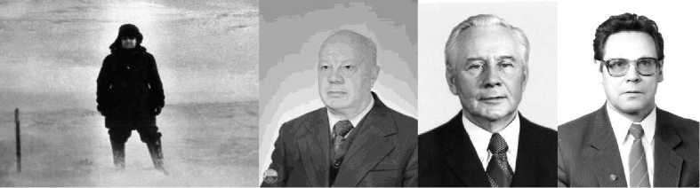
Fig. 1. Interdepartmental State Commission for the selection of the SG-3 location. From right to left: Head of the Kola State Geological Survey, D.M. Guberman, at the site of the SG-3, Academician V.I. Smirnov, Head of the Department of Scientific Research Organizations of the USSR Ministry of Geology, G.I. Gorbunov, his deputy N.P. Laverov. Photo by D.F. Saburova, Kola State Geological Survey, 1968.
Drilling of the Kola well was entrusted to the specially organized Kola geological exploration expedition of the Volgokamskgeologia association (since 1986 — the Nedra association) of the USSR Ministry of Geology and Mineral Resources. Up to 3000 specialists and 16 research laboratories worked at the well at the same time. D.M. Guberman became the head of the Kola geological exploration expedition, and the geologist team included V.S. Lanev, Yu.P. Smirnov, and others [2]. Drilling was started on May 24, 1970 not only to study the most ancient rocks of our planet, but also to discover new deposits of copper-nickel ores of the Pechenga ore field [5, 2, 3].
The purpose of drilling SG-3 was to study the deep structure of the Precambrian structures of the Baltic Shield, typical for the basement of ancient platforms, and to assess their ore-bearing capacity. The main tasks of the works were as follows:
-
• To study the deep structure of the nickel-bearing Pechenga complex and the Archean crystalline basement of the Baltic Shield, to find out the features of geological processes at great depths, including ore-forming processes.
-
• To clarify the geological nature of seismic boundaries in the continental crust and to obtain new data on the thermal regime of the subsoil, deep water solutions and gases.
-
• To obtain fullest possible information on the material composition of rocks and their physical state, to discover and study the border zone between the “granite” and “basalt” layers of the Earth's crust.
-
• To improve the existing and to create new technologies and technical means for drilling and complex geophysical surveys of ultra-deep wells.
The solution of these issues should be based on the results of core examination by geological, petrographic, mineralogical, geochemical methods using optical, X-ray, microprobe, thermal, chemical-analytical, spectroscopic, and other methods of analysis. An important task was to develop technical and technological solutions for drilling wells to ultra-low depths.
The choice of the SG-3 well location was determined by the results of deep seismic sounding along the Barents Sea — Pechenga — Lovno, performed in 1958–1962 [6]. It has been determined that beneath the central and northeastern parts of the Pechenga structure, the upper boundary of the “basalt” layer is at the smallest depth. This part of the Baltic Shield has been studied by deep seismic sounding. Detailed magnetic and gravimetric maps as well as well drilling results are available. It was assumed that there is a granite stratum to a depth of 5 km, after which it was expected to find stronger and more ancient basalt rocks. The geothermal gradient there is lower than in other geological regions and amounts to 1.0–1.2°С per 100 m depth, which greatly facilitated the conditions for well drilling. In addition, crystalline rocks have high strength, which implies the use of a simplified well design.
At the beginning, drilling was carried out with the Uralmash-4E serial drilling rig, which was used for oil and gas exploration and production. It took 4 years to drill to a depth of 7263 metres (Fig.
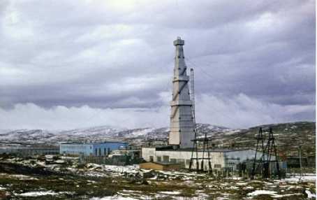
Fig. 2. Drilling rigs of SG-3 — "Uralmash-4E" 1970 (a), "Uralmash-15000" 1984 (b). Photo by D.F. Saburov, Kola State Geological Survey, 1972 and 1977.
b
The first stage of drilling was completed in May 1975, when the well reached a depth of 7263 m. By this time, the section of the Early Proterozoic North Pechengian volcanic-sedimentary rock series was intersected, and the well entered the underlying Archean gneisses. The successful implementation of the first stage of drilling had a decisive influence on the development of the optimal way to develop ultra-deep drilling. One of the most important technical achievements of the first stage of drilling was the development of the technology for drilling wells in crystalline rocks up to 7 km using drilling equipment and tools of domestic production [2]. Then there was a break for almost a year to replace the drilling rig. The Uralmash-4E drilling rig was dismantled, and a specially designed set of Uralmash 15000 drilling equipment with a lifting capacity of 400 tons was installed with maximum automation and stepless regulation of the main technical processes.
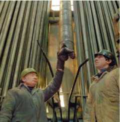
In 1976, after the installation of the drilling complex, the second stage of drilling began. The Chairman of the Presidium of the Kola Scientific Center of the USSR Academy of Sciences, G.I. Gorbunov, and the Head of the Department of Scientific Research Organizations of the USSR Ministry of Geology, N.P. Laverov, came to SG-3 to evaluate its readiness to continue drilling (Fig. 3). This installation was used for further drilling, and it made it possible to penetrate 12262 meters deep into the Earth's crust. In June 1979, the well broke the record of 9583 meters held by the US well, reaching a depth of 9584 meters. In 1983, the well reached a depth of 12066 m. As of 05/01/1991, the well depth was 12262 m [3].
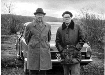
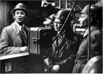
Fig. 3. G.I. Gorbunov, the Chairman of the Presidium of the Kola Branch of the USSR Academy of Sciences, N.P. Laver-ov, the Head of the Department of Scientific Research Organizations of the USSR Mingeo at the SG-3 well in 1976.
Photo by N.P. Laverov, 1973 and 1976.
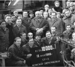
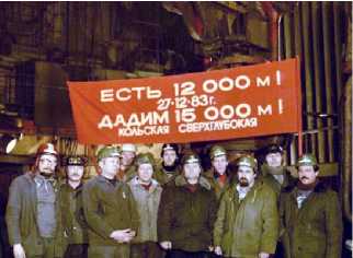
During the second stage of SG-3 drilling, a number of complex technical problems were solved. So, at depths of more than 8 km, it turned out to be practically impossible to control the bit operation using ground sensors and instruments. The investigations revealed the promising of hydraulic communication channel for transmitting the information from downhole sensors to the surface by means of frequency modulation of pressure pulses in fluid [2]. The most important requirements were to ensure maximum core recovery and to maintain borehole verticality. On December 27, 1983, the well depth reached 12000 m, and the drillers were preparing to drill to the target depth (Fig. 4).
а b c
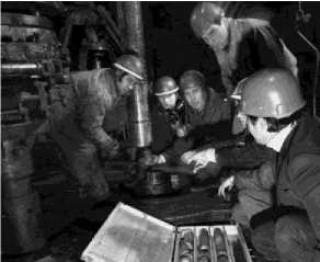
Fig. 4. Stages of SG-3 drilling, 10000 m (a), receiving and laying of core (b), 12000 m (c). Photo by D.F. Saburov, Kola Geological Survey, 1980, 1982, 1983.
After reaching a record depth of 12066 meters, drilling was suspended, as preparations were being made for the XXVII International Geological Congress to be held in Moscow in 1984. The outstanding achievements of the Soviet Union in the field of deep exploration of the Earth's interior attracted geologists, engineers, technologists and other specialists both in our country and abroad. It was decided to report the main results of the SG-3 study at a special session of the Congress and to show the participants the work of the well and the core samples raised from the depths. A special excursion of the ministers of geology of many countries to SG-3 was organized. The Kola superdeep well was recognized as the most outstanding achievement of world science in the 20th century [3]. It was included in the Guinness Book of Records as a world achievement [2, 7].
In 1990, the maximum depth was reached — 12262 m, which has not been surpassed so far. However, a drastic reduction in funding made it impossible to continue the work. Drilling was stopped in 1992. It was assumed that after completion of drilling the Kola superdeep well would be turned into a unique laboratory for the study of deep processes in the Earth's crust using special instruments. However, in 1995, all scientific work was terminated due to lack of funding, and the well itself was mothballed [7, 8].
The decision to dismantle the unique Uralmash 15000 drilling equipment was made in summer 2007 by a special expert commission of Rosnedra and Rosimushchestvo representatives.
Features of SG-3 drilling technology
Drilling of the Kola well was carried out using only domestic equipment and technology. All drilling equipment was made at the enterprises of the USSR defense industry, just as in the nuclear weapons and spacecraft projects. A unique drilling rig “Uralmash 15000” was created with a lifting capacity of 400 tons, with a drilling fluid injection pressure of 40 MPa, with maximum automation of drilling processes. The rig was designed for drilling wells to a depth of 15 km [2].
The industry has mastered the production of more than 30 new types of drilling equipment. For the first time in the world, automated equipment using turbine drilling was used in a drilling rig: when not the entire string rotates, but only the drill head. Drilling fluid was fed through the string under pressure to rotate a 46 m long multistage turbine at the bottom with a 214 mm drill bit. A pipe — a core receiver — passed through all sections of the turbine; it collected the core samples of the drilled rock. In order to create a long drill string, several types of drill pipes made of light alloys based on aluminum have been developed, including those capable of operating at great depths and in high temperatures. A drill string of this length, assembled entirely from steel pipes, would simply break off under its own weight (Fig. 5). In total, more than 50 km of light-alloy pipes were used in the drilling process.
a
b
d
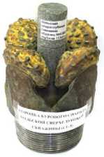
Fig. 5. SG-3, running the turbodrill (a), schematic section of the well (b), actual design of the well (c), drill bit with core (d). a — photo by D.F. Saburov, Kola Geological Survey, 1977, d — photo by K.V. Lobanov, 2019
To drill the well, rock cutting tools and downhole motors for deep conditions with hard-alloy drill bits were designed. One bit served about 4 hours with a 7–10 meter penetration. With a well depth of more than 8000 m, it took up to 18 hours to run the string in and out with its automatic disassembly into sections. The SG-3 was the first in the world to use a monitoring and control system for the drilling process. The information-measuring system included three main software and hardware subsystems: preparation for the trip, control of drilling, and the results. Taking into account the peculiarities of rock drilling, the main task of the system was to recognize critical technological situations [2–3, 6–8].
On September 27, 1984, drilling of SG-3 was continued. Another 9-meter interval was drilled, but the drill string broke off at a depth of more than 12 km. The drill string was stuck while being lifted. A turbodrill and 5 km of drill pipes remained in the well. Only 7 months later, drilling was resumed from a depth of 7000 m.
A lot of similar difficulties, completely unexpected, arose during the drilling and coring the Kola well. To a depth of about 7 km, the borehole intersected solid, relatively homogeneous Proterozoic volcanic-sedimentary rocks, and therefore the borehole was flat, almost corresponding to the diameter of the drill bit. However, less durable, fractured, interbedded Archean rocks — gneisses, amphibolites — went deeper than 7 km. Drilling became more difficult, and the borehole took on an oval shape, many caverns appeared, and accidents became more frequent. After the largest accident in 1984, it took 6 years to reach 12 km depth again.
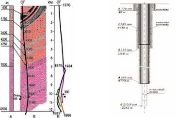
A total of 12 by-pass bores were drilled in the well. Four of them had a length from 2200 m to 5000 m. The borehole branching frustrated the drillers, but delighted the geologists, who unexpectedly got a three-dimensional picture of an impressive array of ancient Archean rocks that formed more than 2.5 billion years ago. Below 7 km, the well is a multilateral mine, the first shaft of which was completed at a depth of 11662 m, the second shaft, drilled from the first one at a depth of 9378 m, reached 12066 m, the third one, started at a depth of 7010 m, ended at 12 262 m, and, finally, the fourth shaft, drilled in the third one at a depth of 9649 m, reached11 882 m (Fig. 5, b) [9]. This was the reason for the duration of the last drilling phase, since up to 60 m were drilled in a month.
The MAG 195/60 core barrel is a device that is attached to the turbodrill shaft and is equipped with a system for hydrotransporting the core through the receiving pipe to the core collector. These projectiles with a hydrotransport system are capable of holding up to 20 m of core with a diameter of 60 mm. More than 70% of the drilling interval was core-traversed with an average core recovery of 40.1% for the whole borehole. The duration of one running-in and pulling-out time at the depth of 12000 m was 21 hours [1].
The SG-3 trunk has a diameter and a circular cross-section only in the upper intervals — up to 6000 m. Cavernous zones in the trunk were only in the zones of tectonic faults, where it had a complex isometric shape. At depths of more than 7000 m, the wellbore had an elliptical section. Cavernous zones were associated with tectonic faults. In the upper intervals, the wellbore is generally resistant to hydrodynamic and mechanical influences, and in the Archean rocks, external influences led to collapse of the borehole walls and significant changes in its radial dimensions. In 1992, a unique operation was carried out to install a casing in the SG-3 borehole to continue drilling the well to a depth of 13 km. However, despite this, further drilling was abandoned.
Geological drilling results
The main task of drilling the Kola superdeep well was to study the deep structure and ore content of the ancient continental crust: obtaining a deep geological section; comprehensive study of the material composition of rocks and the nature of their change with depth; elucidation of the features of endogenous geological processes in the deep parts of the Earth's crust and their connection with ore formation processes; elucidation of the geological nature of deep geophysical boundaries and geophysical parameters of geological strata [3]. The basis for solving these issues was the data obtained during the study of the core, which was taken continuously along the well section and studied comprehensively by various methods. As a result, unique information was obtained, which often significantly changed ideas about the deep structure of the subsoil.
The SG-3 penetration disproved the previous views on the Earth crust structure in the vicinity of Pechenga structure. The design section of the well, based on seismic data, predicted that at a depth of 4 km, the well will emerge from the volcanic-sedimentary rocks of the Pechenga structure and enter the granite-gneisses of the Archean basement. After the drilled three-kilometer layer of granite-gneiss, the well was supposed to sink into the basalt layer. However, the rocks of the Pechenga structure extended to a depth of 6842 m, and only then were replaced by Archean granite-gneisses. The basalt layer was not found at all: up to the record depth, the drill penetrated through the Archean granitoid rocks.
When examining core samples during seismological studies, it was found that compacted granitoids were perceived by geophysicists to be denser than standard rocks. This is new geological information that allows for a different interpretation of the data of deep geophysical surveys (Fig. 6).
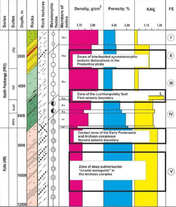
Fig. 6. Formalized section of the Kola superdeep well with tectonic faults zones [8].
The well is located on the northern flank of the Pechenga structure in order to assess the prospects of deep horizons in relation to copper-nickel mineralization, to cross the contact of the Early Proterozoic volcanics with Archean gneisses of the Kola series at the level of 4.7 km, and to penetrate into the “basalt” layer in the interval of 7.5–8.5 km to open Conrad's surface. As for the first task, it was successfully solved. At a depth of 1.5–1.7 km in the middle part of the productive strata, the well discovered a previously unknown body of nickel-bearing hyperbasites. However, the assumption about the presence of Konrad's surface at a depth of 7.5–8.5 km was not confirmed. The bottom of the North Pechenga Group was crossed at the 6.8 km, and up to a record depth of 12 km, the well passed through the gneisses and amphibolites of the Kola Group, i.e. along the “granite” layer of the Earth's crust. It was found that granitoids at great depths were perceived during seismological studies by geophysicists as denser than standard rocks [2, 3].
An important place in the structure of the Pechenga ore field is occupied by interstratal tectonic zones of synmetamorphic shearing, which led to the formation of flaky-block structures [4, 5, 7, 9, 10]. Four tectonic zones are identified in the SG-3 section and on the surface. The values of the petrophysical parameters of rocks in interstratal tectonic zones are characterized by the highest density, porosity, and KAVp.
Petrological studies of the SG-3 core proved the synchronism of the Middle Proterozoic metamorphism and flake-thrust movements of rocks. Determination of the temperatures of metamorphism from the compositions of coexisting minerals and mineral associations confirms the general increase in the intensity of the process with depth. The average temperature of volcanic metamorphism in the upper part of the SG-3 section is 300°C (prenite-pumpellite facies), and the end of the greenschist facies (4900 m) is 450°C. In the epidote-amphibolite facies interval (4900– 6000 m), it is 550°С, and within the amphibolite facies (the lower parts of the North Pechenga Group and the Archean Kola Series), metamorphism temperatures range from 550°С to 650°С (6000–12000 m). The section does not reveal a metamorphic break between the lowermost parts of the Severopechenga and Kola series: according to the mineral associations, both rocks correspond to the amphibolite facies and have crystalline-schisty textures. This suggests that granitization took place within the temperature boundaries of the amphibolite facies [11, 9, 10, 7].
Direct measurements of temperature at great depths were equally interesting and unexpected. It was assumed that in tectonically calm areas, to which the Baltic Shield belongs, the temperature increases insignificantly with depth (approximately 8–10°С per 1 km). However, the real temperature in the borehole at a depth of 10 km reached 180°С, and at a depth of about 12 km, the temperature values reached 212°С, instead of the assumed 120°С [12]. The role of mantle and radiogenic sources in the total depth heat flow was elucidated.
The Kola superdeep borehole provided extensive material on ore mineralization at various depths. The study showed the presence of mineralization in the ancient continental crust over the entire 12 km interval (Fig. 7).
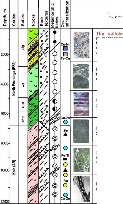
Iron sulfide mineralization of pyrite-pyrrhotite and pyrite ores in tuffogenic-sedimentary rocks of the Productive strata of the Pechenga ore field
Iron oxide mineralization
Types of ore mineralization copper-nickel and platinum-metal mineralization in metaperidotites and phyllites and a previously unknown ore zone in the middle part of the productive strata is similar to the ores of the Pechenga ore field and proves the consistency of Cu-Ni mineralization by a drop of 2.5 km quartz-biotite and
quartz-amphibole-biotite shales of the Archean Kola series
Iron-titanium oxide mineralization in metagabbro bodies occurring in Archean rocks of the Kola series
Sulfide copper-zinc mineralization in zones of regressive dislocation metamorphism in the range of 6.2-12 km in the metabasites of the North Pechenga and amphibolites and gneisses of the Kola series
Native gold mineralization in Archean gneisses and amphibolites at depths of 9500-11000 m
Fig. 7. Vertical ore zoning in the SG-3 section [8].
Six types of mineralization have been identified: sulfide copper-nickel and platinum-metal, sulfide iron, oxide iron, oxide iron-titanium, sulfide copper-zinc and gold-silver. At a depth of 1600–1900 m, an interval of commercial Cu-Ni ores was identified, the study of which made it possible to identify new deposits. The discovery of a previously unknown type of Au-Ag mineralization in the 9500–11000 m interval aroused great interest.
This may be due to increased tectonic activity in the deep horizons of the Earth's crust. Low-temperature hydrothermal mineralization (copper, copper-zinc, nickel) was deposited in the zones of groundwater circulation recorded at great depths (6.5–11.5 km and more).
The data on the processes of ore formation in the deep layers of the Earth's crust also turned out to be fundamentally new. Highly porous fractured rocks saturated with highly mineralized underground waters were encountered at depths of 9–12 km. These waters are one of the sources of ore formation. This was previously thought to be possible only at much shallower depths. The low-temperature ore minerals associations found in the well indicate the fundamental possibility of their industrial accumulations at these depths, not to mention high-temperature ore formations. This conclusion is of fundamental importance for the development of the theory of minerals and prospecting for ore deposits at great depths [4]. New data on ore formation at great depths was registered as scientific discovery No. 28 in the field of Earth Sciences.
Conclusion
The Kola superdeep well is an outstanding achievement of world and Russian geological science in the development of continental drilling. It was drilled within the framework of the “Exploration of the Earth's interior and superdeep drilling” program. All work under this program was carried out using only domestic equipment and technology. All drilling equipment was made at the enterprises of the USSR defense industry, as well as in nuclear weapons and spacecraft projects. The unique drilling rig Uralmash 15000 was created.
For the first time in the world, SG-3 was drilled using the latest domestic technical means, scientific study of the deep structure of the earth's interior. New materials and drilling technologies have been used, and unique drilling equipment has been created, which made it possible to reach previously inaccessible depths. This result has been unrivaled for 50 years. SG-3 is a breakthrough into the bowels of the Earth and can only be compared with a flight into space.
The joint work of about 200 scientists and specialists from scientific and industrial organizations of various ministries and departments made it possible to obtain material from such depths and to measure various parameters directly in the Earth's crust to a depth of 12262 m using new scientific equipment capable of operating in high temperatures and pressures. The obtained samples of rocks from great depths are comparable in value to samples from the Moon.
Geological and geophysical information on the deep structure of the Baltic Shield has significantly corrected the theoretical concepts that prevailed before drilling the well. Based on the study of the mineral-geochemical composition of the core rocks and a complex of studies in the SG-3 shaft, data on the material composition and physical state of deep rocks were obtained.
The geophysical boundary, which gives the greatest reflection during seismic sounding, where the rocks of the “granite” layer pass into a stronger “basalt layer”, in the SG-3 section, indicates that there are less strong and less dense fractured rocks — Archean gneisses. Instead of the “Konrad surface” (the top of the basalt layer), a sub-horizontal “crustal waveguide” was identified, a kind of decompaction zone, the movement of tectonic blocks along these zones provided the flake-thrust structure of the entire Lapland-Pechenga block.
New data were obtained when assessing temperatures at great depths. It was assumed that in the granite-gneiss basement of the Baltic Shield, the temperature increases insignificantly with depth (by about 8–10°С per 1 km). The real temperature in SG-3 at a depth of 10 km reached 180°С, and at a depth of about 12 km — 212°С, instead of the expected 120°С.
The SG-3 study showed the presence of ore mineralization in the ancient continental crust over the entire 12 km interval. Six types of mineralization have been identified: sulfide coppernickel and platinum-metal, sulfide iron, oxide iron, oxide iron-titanium, sulfide copper-zinc and gold-silver. The data on the process of ore formation in the deep layers of the Earth's crust also turned out to be fundamentally new. Thus, at depths of 9–12 km, highly porous fractured rocks saturated with highly mineralized underground waters were encountered. These waters are one of the sources of ore formation. Previously, it was believed that this is possible only at much shallower depths.
Acknowledgments and funding
This research was financially supported by the RFBR project (Grant No. 18-05-70001) “Study of the geological and geodynamic environments of the formation of large deposits of strategic metals in the Arctic zone of Russia: conclusions for forecasting and prospecting for new deposits” and budget topics of the Institute.
References The 50th Anniversary of the Start of Drilling the Kola Superdeep Well
- Povalikhin A.S. 50 let nauchnomu proryvu v issledovanii Zemli. Kol'skaya sverkhglubokaya skvazhina: put' k energeticheskomu i syr'evomu obespecheniyu chelovechestva [Fifty Years since the Scientific Breakthrough in the Earth's Studying. Kola Super Deep Well is a Way to Energy and Mineral Provi-sion of the Mankind]. Inzhener neftyanik [Petroleum Engineer], 2020, no. 1, pp. 5 16.
- Kozlovskiy E.A. Kol'skaya sverkhglubokaya. Issledovanie glubinnoy struktury kontinental'noy kory bu-reniem Kol'skoy sverkhglubokoy skvazhiny [Kola Superdeep. Investigation of the Deep Structure of the Continental Crust by Drilling the Kola Superdeep Borehole]. Moscow, Nedra Publ., 1984, 490 p. (In Russ.)
- Orlov V.P., Laverov N.P. Kol'skaya sverkhglubokaya: Nauchnye rezul'taty i opyt issledovaniy [Kola Su-perdeep: Scientific Results and Research Experience]. Moscow, MF “TEKHNONEFTEGAZ” Publ., 1998, 260 p. (In Russ.)
- Kazanskiy V.I., Kuznetsov O.L., Kuznetsov A.V., Lobanov K.V., Cheremisina E.N. Glubinnoe stroenie i geodinamika Pechengskogo rudnogo rayona: opyt issledovaniya Kol'skoy sverkhglubokoy skvazhiny [Deep Structure and Geodynamics of the Pechenga Ore Region: the Experience of Researching the Kola Superdeep Well]. Geologiya rudnykh mestorozhdeniy [Geologiâ Rudnyh Mestoroždenij], 1994, vol. 36, no. 6, pp. 500 519.
- Kazanskiy V.I., Lobanov K.V. Glubinnoe stroenie i rudonosnost' drevney kontinental'noy zemnoy kory (po rezul'tatam issledovaniy Kol'skoy sverkhglubokoy skvazhiny) [Deep Structure and Ore Content of the Ancient Continental Crust (Based on the Results of Studies of the Kola Superdeep Well)]. Prob-lemy rudnoy geologii, petrologii, mineralogii i geokhimii [Problems of Ore Geology, Petrology, Min-eralogy and Geochemistry]. Moscow, IGEM RAN Publ., 2004, pp. 24 43.
- Litvinenko I.V., Lenina I.S. Nekotorye rezul'taty izucheniya seysmorazvedkoy glubinnogo stroeniya Pechengskoy struktury [Some Results of Seismic Exploration of the Deep Structure of the Pechenga Structure]. Geologiya i glubinnoe stroenie vostochnoy chasti Baltiyskogo shchita [Geology and Deep Structure of the Eastern Part of the Baltic Shield]. Leningrad, Nedra Publ., 1968, pp. 139 147. (In Russ.)
- Lobanov K.V., Kazanskiy V.I., Kuznetsov A.V., Zharikov A.V. Integral'naya geodinamicheskaya model' Pechengskogo rudnogo rayona na osnove korrelyatsii geologicheskikh, petrologicheskikh i petrofizi-cheskikh dannykh po Kol'skoy sverkhglubokoy skvazhine i opornomu profilyu na poverkhnosti [Inte-gral Geodynamic Model of the Pechenga Ore Region Based on the Correlation of Geological, Petro-logical and Petrophysical Data on the Kola Superdeep Well and the Reference Profile on the Sur-face]. Sovremennye problemy rudnoy geologii, petrologii, mineralogii i geokhimii [Modern Problems of Ore Geology, Petrology, Mineralogy and Geochemistry]. Moscow, IGEM RAN Publ., 2010, pp. 258 300.
- Lobanov K.V., Chicherov M.V., Chizhova I.A., Gornostaeva T.A., Sharov N.V. Glubinnoe stroenie i rudoobrazuyushchie sistemy Pechengskogo rudnogo rayona (arkticheskaya zona Rossii) [Depth Structure and Ore Forming Systems of the Pechenga Ore Region (Russian Arctic Zone)]. Arktika: ekologiya i ekonomika [Arctic: Ecology and Economy], 2019, no. 3, pp. 107 122.
- Kazanskiy V.I., Lobanov K.V. Strukturno-geofizicheskaya pozitsiya, glubinnoe stroenie i usloviya lo-kalizatsii unikal'nogo Pechengskogo rudnogo polya (Baltiyskiy shchit) [Structural-Geophysical Position, Deep Structure and Localization Conditions of the Unique Pechenga Ore Field (Baltic Shield)]. Krupnye i superkrupnye mestorozhdeniya: zakonomernosti razmeshcheniya i usloviya obrazovaniya [Large and Super-Large Deposits: Distribution Patterns and Formation Conditions]. Moscow, IGEM RAN Publ., 2004, pp. 187–205.
- Kazansky V.I., Lobanov K.V., Sharov N.V. Ot razreza Kol'skoy sverkhglubokoy skvazhiny k glubinnym modelyam Pechengskogo rudnogo rayona: k 10 letiyu otkrytiya № 28 v oblasti nauk o Zemle [From the Kola Superdeep Borehole Section towards Depth Models of the Pechenga Ore District: 10th An-niversary of the Discovery No. 28 in Earth Sciences]. Vestnik Rossiyskoy Akademii estestvennykh nauk [Bulletin of the Russian Academy of Natural Sciences], 2007, vol. 7, no. 2, pp. 3 7.
- Glagolev A.A., Genkin A.D., Kazanskiy V.I., Boronikhin V.A., Gordienko L.P., Krasivskaya I.S., Kuznetsov A.V., Lobanov K.V., Nosik L.P., Prokhorov K.V. Izuchenie endogennykh protsessov po materialam sverkhglubokogo bureniya [Study of Endogenous Processes Based on Superdeep Drilling Materials]. Endogennye rudnye rayony i mestorozhdeniya [Endogenous Ore Regions and Deposits], Moscow, Nauka Publ., 1987, pp. 129 144.
- Khitarov N.I. K voprosu provedeniya sverkhglubokogo bureniya na territorii Sovetskogo Soyuza [On the Issue of Superdeep Drilling on the Territory of the Soviet Union]. Sovetskaya geologiya [Soviet Geology], 1961, no. 6, pp. 134 138.
