The Aul-Koshkul-1 Cemetery in the Baraba Forest-Steppe: Findings of a Multidisciplinary Study

Author: Balkov E.V., Karin Y.G., Pozdnyakova O.A., Dyadkov P.G., Goglev D.A.
Journal: Archaeology, Ethnology & Anthropology of Eurasia @journal-aeae-en
Section: The metal ages and medieval period
Article in issue: 1 т.50, 2022.
Free access
We present the results of aerial photographic and magnetometric studies at Aul-Koshkul-1, a group of mounds in the Baraba forest-steppe. Photogrammetry proved highly efficient for constructing orthophotographic plans and digital models of outward features at archaeological sites. Data were processed with an original approach, generating a map of relative heights, decreasing the effect of natural relief and highlighting altitudinal anomalies of an anthropogenic origin. Aerial photography is highly efficient for revealing archaeological features that are hard to locate by visual analysis of the surface (mounds destroyed by tillage, shallow ditches, etc.). Orthophotographic plans constructed by aerial photography in oblique sun rays at sunset present the most contrastive representations. Aerial magnetometry revealed most mounds at Aul-Koshkul-1, although the site was surveyed with minimal accuracy because magnetic anomalies caused by archaeological features were rare. Our multidisciplinary study yielded new information about the mounds previously registered by ground-based magnetometry, and discovered new features, leading to a revision of the cemetery’s reconstructed boundaries and composition. The study demonstrates the great potential of a joint use of aerial magnetometry and aerial photography for locating and studying archaeological sites at a new, sophisticated level.
Aerial magnetometry, aerial photography, unmanned aerial vehicles, photogrammetry, archaeological and geophysical research, burial mounds
Short address: https://sciup.org/145146852
IDR: 145146852 | DOI: 10.17746/1563-0110.2022.50.1.138-146
Text of the scientific article The Aul-Koshkul-1 Cemetery in the Baraba Forest-Steppe: Findings of a Multidisciplinary Study
Ground-based magnetometry has been successfully used in archaeology for more than 50 years (Neubauer, 2002; Fassbinder, 2019). At the present stage, the development of miniature unmanned aerial vehicles (UAVs) makes it possible to bring it to a new level of performance and to map large areas (up to several hectares in one working day) without losing horizontal resolution. Aerial magnetometry in archaeological research is not yet widely used; however, the first results, obtained mostly on the territory of Russia, show undoubted prospects for
this direction (Epov et al., 2016; Goglev, 2018; Firsov et al., 2018; Balkov et al., 2019; Schmidt, Becken, Schmalzl, 2020). Unlike aerial magnetometry, aerial photography through the use of UAVs is increasingly used to search for and study archaeological sites (Bykov et al., 2012; Risbol, Gustavsen, 2018; Balkov et al., 2020; Brooke, Clutterbuck, 2020; Alvarez Larrain, Greco, Tarragó, 2020). The orthophotographic plans and digital elevation models obtained as a result of aerial photography have a high degree of detail and, in some cases, provide no less significant information about archaeological sites than magnetometry (Vavulin et al., 2021). Thus, the use of aerial photography, together with a set of geophysical methods, makes it possible to obtain maximum information about the site, without violating its integrity (Bakhshiev, Noskevich, Nasretdinov, 2018). Taking into account the current trends in the development of archaeology, which involve the widespread use of non-destructive methods, the development of this trend, along with its testing in various natural and landscape conditions, are very relevant.
This article discusses the results of archaeological and geophysical work at the cemetery of Aul-Koshkul-1, where the combined use of aerial photography and aerial magnetomrtry from UAVs, in addition to research from previous years, made it possible to obtain new information about the boundaries and composition of the archaeological site. The purpose of the research was not only to test and demonstrate the capabilities of the above methods, but also to develop approaches to material processing for the most informative visualization of data. The obtained results contribute to the development of the methodology of archaeological and geophysical research, and significantly increase the efficiency of work based on the application of the magnetometry method.
The site and its research to date
The Aul-Koshkul-1 archaeological site is located in the Chanovsky District of the Novosibirsk Region, 2 km north of the Chany village. It is located on a slightly elevated area at the edge of a vast lake floodplain. The cemetery was discovered by the local residents in 2010. Six mounds 7–14 m in diameter and 0.28–0.47 m high were visually identified in the area of the site (Fig. 1, a ). Ditches are recorded around mounds 3 and 4, one of which (mound 4) encircles the area with a diameter of 30 m. Similar to the last one is a ditch (possibly from an unfinished building structure) surrounding the area of 35 × 45 m, in the southern part of the site. The finds discovered in the destroyed mound 3 made it possible to date the burial site to the Old Turkic period (Molodin et al., 2010).
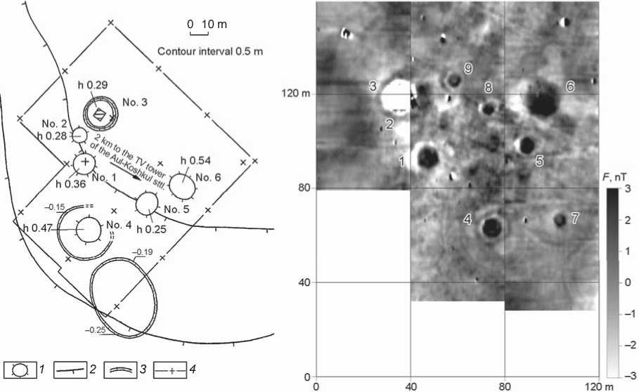
Fig. 1. Plan of the Aul-Koshkul-1 cemetery before the start of geophysical work ( a ) and map of distribution of the magnetic field gradient in the studied area ( b ) (after (Molodin et al., 2010: Fig. 3, 6)).
1 – mound; 2 – contour interval; 3 – ditch; 4 – boundaries of geophysical marking.
60 m
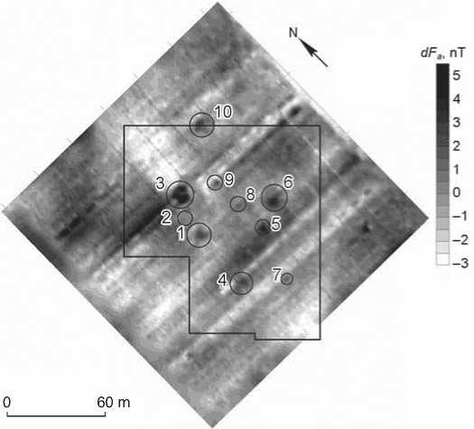
Fig. 2 . Map of distribution of the anomalous magnetic field, based on the results of the aeromagnetic survey of the Aul-Koshkul-1 cemetery in 2016 (after (Firsov et al., 2018: Fig. 3, a )).
а
which allowed us to assume the presence of a less magnetic, clay soil in its composition. The results of magnetic survey confirmed the absence of ditches around most of the mounds; and near mound 4, another inner ditch was revealed. In the space between structures No. 1, 4–6, three more mounds were revealed (No. 7–9) with diameters of approx. 5 m, which did not appear on the surface (Ibid.).
In 2016, at the Aul-Koshkul-1 site, experimental and methodological work was carried out to test aerial magnetometry from UAVs. The correlation with the ground-based magnetometric data showed that it was possible to detect seven of the nine previously identified mounds (Fig. 2), using aeromagnetic mapping. Near the northwestern boundary of the ground survey area, mound 10 was found, comparable in size to the largest structures of the site (Firsov et al., 2018).
Thus, thanks to the ground-based and aerial magnetometric surveys, it was possible to determine the features of mounds’ construction and to identify in the space between them the archaeological features that were not visible externally. A large amount of additional information was obtained, and the total number of structures reliably identified within the archaeological site increased to 11.
New research cycle(methods, equipment, and software)
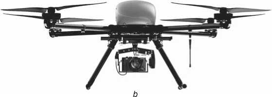
Fig. 3. Unmanned aerial vehicles used for aerial photography. a – mini drone DJI Mavic Air (China); b – Geoscan 401 (Russia).
In the same year, under the agreement on scientific cooperation between the Institute of Archaeology and Ethnography SB RAS and the German Archaeological Institute, ground-based magnetic survey was carried out on the site, under the direction of J.W.E. Fassbinder. On the constructed magnetic map (Fig. 1, b ), traces of plowing were clearly visible. The mounds of mounds stood out as positive anomalies of a rounded shape, while mounds 2 and 3 appeared as a negative anomaly,
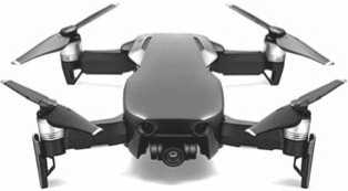
In 2020, as part of the Russian Foundation for Basic Research integration project, the Aul-Koshkul-1 mound cemetery was chosen as a testing ground for modern methodological tools using unmanned aerial vehicles. Aerial photography was carried out using a mini drone DJI Mavic Air (DJI, China) and a professional complex Geoscan 401 (Geoscan, Russia) (Fig. 3). In the course of work with the DJI Mavic Air equipment, Drone Harmony Plus software (Drone Harmony Infrastructure digitalization, Switzerland) was used for flight planning. The photogrammetry data were processed using Metashape software (Agisoft, Russia). Processing, design, visualization of the digital relief models and maps of relative heights were performed using Surfer software (Golden Software, USA).
When processing aerial photography data, an original approach was used; it consisted in constructing a map of relative heights. This reduces the influence of the natural terrain and emphasizes the altitudinal anomalies of anthropogenic origin, which increases the efficiency of the analysis of the digital elevation model.
Work on high-precision aeromagnetic survey was carried out using a Geoscan 401 Geophysics quantum magnetometer (Fig. 4). The final processing of the obtained data consisted in subtracting from them the daily variations of the magnetic field, regional anomalies, and in smoothing the data.
After a preliminary analysis of the results of the work of previous years, as well as satellite images of the site, several plots were selected for research (Fig. 5). On the largest of them (about 70 ha), aerial photography was carried out by the Geoscan 401 magnetometer. The data obtained were used to develop a detailed orthophotographic plan and a map of relative heights. Aerial magnetometry was carried out on a plot of approximately 12 hectares. The area of the aerial photographic survey (with the mini DJI Mavic Air drone) was more than 4 hectares.
Orthophotographic plans and elevation maps
Aerial photography by the professional Geoscan 401 magnetometer was carried out in the middle of the day, with the most intense sunlight. This made it possible to get the highest quality data for building a digital elevation model. However, the final orthophotographic plan, despite its high resolution, did not provide sufficient information about the archaeological sites. Therefore, with the help of the DJI Mavic Air drone, a detailed evening survey was carried out in the area of concentration of the mounds, in the slanting sunlight. It better reflects and emphasizes the features of the terrain (Fig. 6).
The most effective for the search and detailed analysis of archaeological sites turned out to be the data of a digital elevation model. For example, on a fragment of the map of absolute heights, visualized in the form of an illuminated colored 3D-surface, all visually fixed mounds were clearly visible, with the exception of mound 2 (see Fig. 1; 7). Mounds 8 and 9, identified with the help of ground-based magnetometry, are not distinguished, since they are located in the zone of intense plowing, which was designated on the map of absolute heights as an area with a pronounced linear microrelief. It is very clearly seen that the northeastern edge of mound 4 was also plowed up. This
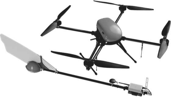
Fig. 4 . Geoscan 401 Geophysics complex for high-precision aeromagnetic survey.
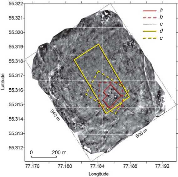
Fig. 5 . Map of relative heights of the Aul-Koshkul-1 cemetery, and contours of the sites studied in different years (2010–2020).
a – boundary of ground-based magnetometry (2010); b – boundary of aerial magnetometry (2016); c – boundary of aerial photography (Geoscan 401, 2020); d – boundary of aerial magnetometry (Geoscan 401, 2020); e – boundary of aerial photography (Mavic Air, 2020).
is also confirmed by the situational plan of the site, where the ditch surrounding the mound is not marked. It is clearly recorded that mound 7 was plowed up almost completely (only the western segment of the ditch has been preserved). Probably for this reason, it was not possible to distinguish it visually, although the mound is very well read on the map of absolute heights, and its spatial parameters and structure are quite clearly identified.
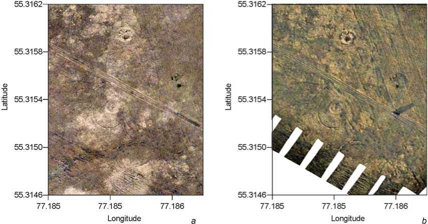
Fig. 6 . Fragments of orthophotographic plans based on the data of aerial photography taken in the middle of the day ( a ) and in the evening ( b ).
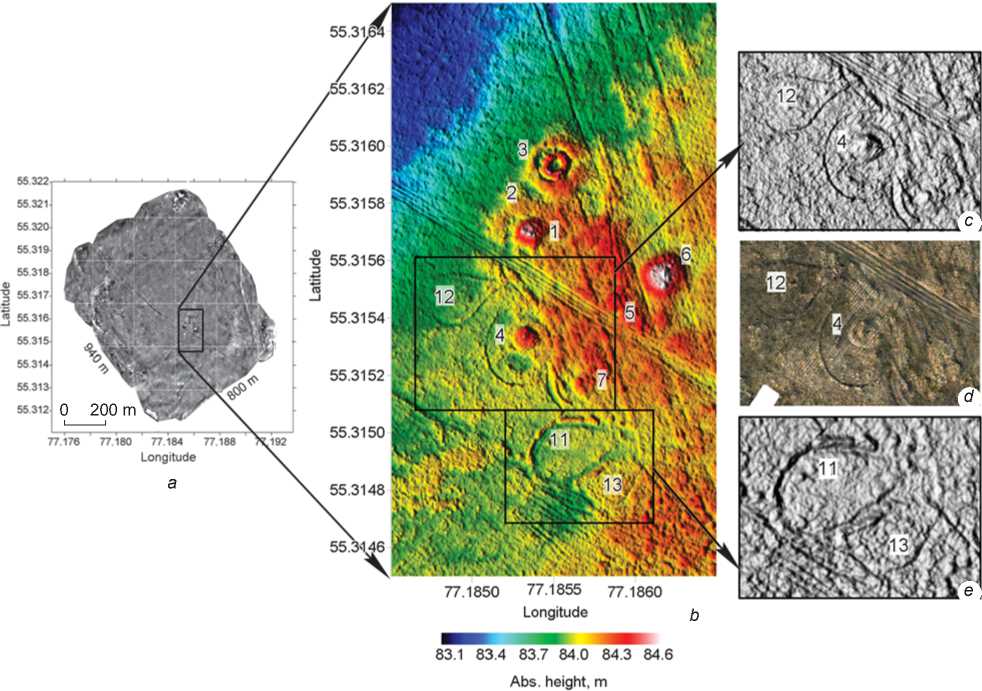
Fig. 7 . Fragments of maps of absolute and relative heights.
a – total study area; b – fragment of the map of absolute heights; c , e – fragments of the shadow map of relative heights, illumination angle 183° horizontally and 45° vertically; d – fragment of the orthophotographic plan in oblique rays.
According to the digital relief model data, three dropshaped structures are also clearly recorded (No. 11–13). Object 11 was identified at the initial stage of research and was tentatively interpreted as an unfinished structure. Findings of aerial photography made it possible to correct the idea of its shape and spatial orientation (see Fig. 1; 7). It is adjoined by object 13, which was not previously discovered. Object 12 is quite well visible on the ground-based magnetometry map, but it became possible to distinguish only after analyzing the orthophotographic plans and elevation maps. All these structures are best emphasized by choosing the angle of illumination when building a grayscale shadow map using the Surfer software (see Fig. 7). Notably, a very similar situation is observed on the orthophotographic plan built according to the data of evening shooting in oblique rays (see Fig. 6, b ). The color of vegetation can also emphasize the relief of the surface and reflect the mounds’ structural features. In places of depressions, where moisture accumulates, vegetation is denser and shows intense green color. On flat areas and uplands, the vegetation cover is not as dense and is characterized by lighter shades. This is clearly seen in the example of mound 4 (see Fig. 7).
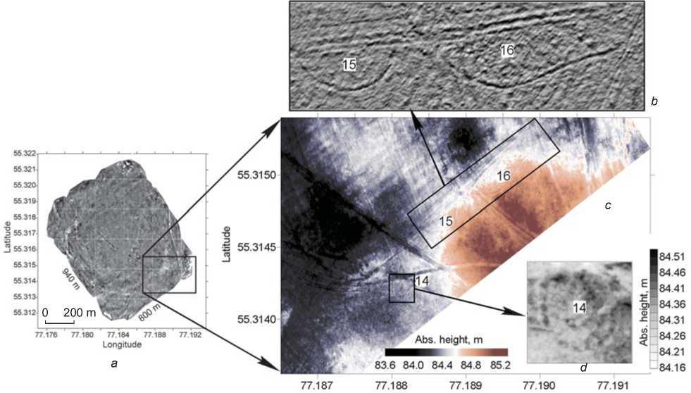
As a result of the analysis of the APS data, several more new objects were identified to the south of the originally designated area of the Aul-Koshkul-1 cemetery. They are confined to the highest point of the studied area and are similar in their parameters to the drop-shaped structures described above (Fig. 8). Objects 15 and 16 are heavily disturbed by plowing, and their original shape and size are unclear. The ring structure 14 is weakly expressed in the relief (height difference no more than 10 cm) and is almost invisible on the orthophotographic plan; however, it is well detected on the detailed fragment of the elevation map. It is very likely that all these objects are artificial and constitute the funeral and ritual complex. In this case, the boundaries of the site should be significantly expanded.
Aerial magnetometry
Ground-based and aerial magnetometry carried out earlier on the territory of the Aul-Koshkul-1 cemetery revealed a rather low intensity of anomalies associated with the archaeological features. This is also confirmed by the results of the 2020 aerial magnetometric surveys conducted at an average height of 5 m with a satellite positioner of sub-meter accuracy. The described factors that complicate the identification of anomalies
Longitude
Fig. 8 . Fragments of maps of absolute and relative heights on the southern periphery of the cemetery.
a – total study area; b – fragment of the shadow map of relative heights, the angle of inclination of the light source is 142° horizontally and 31° vertically; c – fragment of the map of absolute heights; d – fragment of the map of absolute heights.
b
а
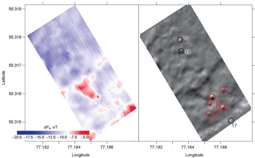
Fig. 9. Maps of the modulus of the total magnetic field vector, corrected to diurnal variations ( a ) and the first derivative (angle 308°) of the anomalous magnetic field ( b ).
from archaeological features were supplemented by a pronounced structure of complex regional anomalies (Fig. 9, a ). Nevertheless, the constructed magnetic maps contain anomalies of low intensity, which can be associated with archaeological structures (Fig. 9, b ). Of the ten mounds identified earlier, only six stand out (No. 1, 3–6, 10). The rest of the mounds, as well as the drop-shaped features (No. 11–13) discovered with the help of aerial photography, were not recorded by aeromagnetic surveys. Thus, according to the results of the work carried out, it was possible to identify only fairly large structures consisting of relief mounds.
Outside the areas of earlier magnetic surveys, only one anomaly can be tentatively interpreted as a mound (No. 17). It is located on a hill southeast of the main complex. The absence of relief features can be explained by the location of this object in the plowing zone. Two more magnetic anomalies (No. 18, 19) are identified to the northwest of the burial ground. Since the natural relief of the area here becomes significantly lower, they cannot be confidently associated with archaeological structures. Perhaps, the source of these anomalies are metal items lying in the ground.
Conclusions
The studies have clearly demonstrated the high efficiency of the integrated approach in the archaeological and geophysical research. The results obtained are a very good example of how the understanding of the composition and boundaries of an archaeological site can change. Through visual fixation, only six mounds and one (possibly unfinished) structure were identified at Aul-Koshkul-1. Ground-based magnetometry made it possible to obtain the actual plan of the site and to discover three new burial mounds that were not expressed in relief. The first experimental work on the application of the aerial magnetometry method has not only demonstrated how to increase the efficiency of magnetic prospecting, but also revealed another mound outside the ground-based magnetometry area. Thus, as a result of magnetic surveys, the total number of structures found at the cemetery increased to 11.
Thanks to the complex use of aerial photography and aerial magnetometry, it was possible to obtain a large amount of additional information. The high efficiency of constructing orthophotographic plans and digital elevation models for detailing the relief structures and clarifying their spatial characteristics has been demonstrated. The aerial photography method proved to be highly effective primarily in identifying archaeological features poorly expressed in relief, which are hard to locate by visual analysis of the surface (mound 7, objects in the form of shallow ditches). Notably, orthophotographic plans built according to aerial photography data in the oblique rays of the setting sun provide for the presentation of photographic information about archaeological complexes in the most advantageous way. At the same time, digital elevation models derived from shooting at noon can capture even the very weakly expressed features.
The aeromagnetic survey of the burial mound of Aul-Koshkul-1 was carried out at the limit of accuracy of the method owing to the low intensity of magnetic anomalies associated with archaeological structures. Nevertheless, most of the mounds managed to be identified. With a greater degree of contrast between archaeological features and the host environment, the information content of the survey would be higher (Balkov et al., 2019). It is also worth noting that with the high performance of the magnetometer and the UAV carrier, navigation tools served as a significant limitation. It is necessary to introduce differential means for taxiing and positioning using real-time kinematic (RTK GNSS). In this case, it will be possible to carry out a high-performance aerial survey at a low altitude (about 1 m), comparable in quality and data density to the ground-based magnetometry. It is important to emphasize that aerial magnetometry, in combination with aerial photography, helps solving the archaeological issues on locating and studying sites at a new, sophisticated level. Both methods are highly productive and can be used for prospecting large areas within a short time. Since they involve essentially different characteristics of archaeological features (relief and magnetic), the information obtained will be more complete and relevant.
At a new stage of archaeological and geophysical studies of the Aul-Koshkul-1 cemetery, five new objects were identified with the help of aerial photography, and presumably three more with aerial magnetometry. Analyzing the totality of information, one can question not only the expansion of the initially established boundaries of the site, but also the simultaneity of formation of its parts. All objects in the form of shallow ditches are confined to the very edge of the terrace; they have no absolute parallels. These are very similar to the outer ditch of mound 4, which is also situated here and is very close in its structure to the burial mounds of the Early Scythian era. The rest of the objects are different in their structure and are located in the depths of the terrace, including partially destroyed mound 3, whose materials attribute the cemetery to the Old Turkic period.
Importantly, the composition of the site can be expanded in the future, since five more objects were identified so far on its southern periphery, according to the aerial photographic data. However, their man-made nature is not so obvious; therefore, analysis of these objects requires the use of other research methods and the additional interpretation of data.
Acknowledgments
The study was supported by the Russian Foundation for Basic Research, Project No. 17-29-04314. The development of the hardware and methodological base and the approaches to interpretation of field measurements is carried out at the Institute of Petroleum Geology and Geophysics (IPGG) SB RAS, under the Program for Basic Research, Project No. 0331-2019-0015.
References The Aul-Koshkul-1 Cemetery in the Baraba Forest-Steppe: Findings of a Multidisciplinary Study
- Alvarez Larrain A., Greco C., Tarragó M. 2020 Participatory mapping and UAV photogrammetry as complementary techniques for landscape archaeology studies: An example from north-western Argentina. Archaeological Prospection, vol. 28 (1): 1-15.
- Bakhshiev I.I., Noskevich V.V., Nasretdinov R.R. 2018 Geofizicheskiye i distantsionniye issledovaniya ukreplennogo poseleniya epokhi bronzy Ulak-1 v Bashkirskom Zauralye: Sootnosheniye poluchennykh dannykh s rezultatami arkheologicheskikh raskopok. Povolzhskaya arkheologiya, No. 3: 30-44.
- Balkov E.V., Dyadkov P.G., Pozdnyakova O.A., Kuleshov D.A., Evmenov N.D., Karin Y.G., Goglev D.A. 2019 Vysokotochnaya magnitnaya syemka s ispolzovaniyem BPLA pri poiske i issledovanii kurganov arkheologicheskogo pamyatnika Novaya Kurya v Zapadnoy Sibiri. Vestnik Novosibirskogo gosudarstvennogo universiteta. Ser.: Informatsionniye tekhnologii, vol. 17 (4): 5-12.
- Balkov E.V., Karin Y.G., Pozdnyakova O.A., Goglev D.A., Shaparenko I.O. 2020 Ortofotosyemka v poiskovykh zadachakh arkheologii: Obzor i prakticheskiye primery ispolzovaniya. Geofizicheskiye tekhnologii, No. 3: 38-47.
- Brooke C., Clutterbuck B. 2020 Mapping heterogeneous buried archaeological features using multisensory data from unmanned aerial vehicles. Remote Sensing, vol. 12, iss. 1 (41).
- Bykov L.V., Bykov A.L., Lashov M.V., Tataurova L.V. 2012 Geodezicheskoye obespecheniye arkheologicheskikh issledovaniy. Vestnik Omskogo gosudarstvennogo universiteta, No. 3: 85-93.
- Epov M.I., Molodin V.I., Pozdnyakova O.A., Zlygostev I.N., Firsov A.P., Savluk A.V., Kolesov A.S., Dyadkov P.G. 2016 Opyt magnitometricheskogo kartirovaniya arkheologicheskikh pamyatnikov s ispolzovaniyem bespilotnykh letatelnykh apparatov. In Problemy arkheologii, etnografii, antropologii Sibiri i sopredelnykh territoriy, vol. XXII. Novosibirsk: Izd. IAET SO RAN, pp. 478-282.
- Fassbinder J.W.E. 2019 Magnitometriya v arkheologii - ot teorii k praktike. Rossiyskaya arkheologiya, No. 2: 75-91.
- Firsov A.P., Zlygostev I.V., Pozdnyakova O.A., Savluk A.V., Vasilevsky A.N. 2018 Magnitnaya syemka s BPLA: Noviye vozmozhnosti v arkheologii. In Virtualnaya arkheologiya (s vozdukha, na zemle, pod vodoy i v muzeye): Materialy Mezhdunar. foruma. St. Petersburg: Izd. Gos. Ermitazha, pp. 256-264.
- Goglev D.A. 2018 Malovysotnaya aeromagnitnaya syemka s primeneniyem bespilotnykh vozdushnykh system na baze kvadrokoptera v arkheologii. Geoprofi , No. 6: 20-22.
- Molodin V.I., Fassbinder J., Gorka T., Pozdnyakova O.A., Chemyakina M.A., Durakov I.A., Hansen S., Nagler A. 2010 Noviy mogilnik drevnetyurkskogo vremeni Aul-Koshkul-1 v Barabinskoy lesostepi: Geofizicheskiye issledovaniya. Vestnik Novosibirskogo gosudarstvennogo universiteta. Ser.: Istoriya, filologiya, vol. 10. Iss 3: Arkheologiya i etnografi ya: 74-84.
- Neubauer W. 2002 Magnetische Prospektion in der Archäologie. Wien: Österreichischen Akademie der Wissenschaft.
- Risbol O., Gustavsen L. 2018 LiDAR from drones employed for mapping archaeology: Potential, benefits and challenges. Archaeological Prospection, vol. 25 (4): 1-10.
- Schmidt V., Becken M., Schmalzl J. 2020 A UAV-borne magnetic survey for archaeological prospection of a Celtic burial site. First Break, vol. 38 (8): 61-66.
- Vavulin M.V., Chugunov K.V., Zaitseva O.E., Vodyasov E.V., Pushkarev A.A. 2021 UAV-based photogrammetry: Assessing the application potential and effectiveness for archaeological monitoring and surveying in the research on the ‘valley of the kings’ (Tuva, Russia). Digital Applications in Archaeology and Cultural Heritage, vol. 20.
