The Distribution of Public Facilities and Its Impact on Urban Dynamics in the City of Tissemsilt

Author: Labed N.A., Tahraoui F.
Journal: Science, Education and Innovations in the Context of Modern Problems @imcra
Article in issue: 2 vol.8, 2025.
Free access
The spatial distribution of public facilities is a key factor shaping urban development, influencing city structure and growth patterns through spatial balance and functional efficiency. This study examines the relationship between public facility distribution, socio-demographic changes, and spatial evolution in Tissemsilt using Geographic Information Systems (GIS) and statistical analysis. Findings reveal uneven facility allocation, with high concentrations in specific areas, leading to disparities in service accessibility and unbalanced urban growth. Tissemsilt's urban dynamics are driven by rapid population growth, informal urban expansion, and rigid planning frameworks that struggle to meet evolving needs. The study emphasizes that restructuring facility distribution through strategic planning and spatial equity can foster sustainable development. It recommends adaptive planning models tailored to the city’s socio-economic characteristics and periodic assessments to ensure alignment with changing urban demands.
Spatial distribution, urban dynamics, Public facilities, Sustainable development, Strategic planning
Short address: https://sciup.org/16010430
IDR: 16010430 | DOI: 10.56334/sei/8.2.39
Text of the scientific article The Distribution of Public Facilities and Its Impact on Urban Dynamics in the City of Tissemsilt
Urban dynamics result from a complex interplay of internal and external forces that shape the structural and functional evolution of cities (Bettencourt, 2021). As an intrinsic phenomenon of urban development, urban growth directly influences the morphological configuration of cities, reshaping their spatial organization, economic structures, and socio-demographic composition. However, a fundamental challenge arises from the absence of a clear conceptual framework that explains the role of emerging urban agglomerations in the dynamic transformation of urban systems. The process of urban expansion is not merely a function of population increase but is deeply embedded in the spatial logic of infrastructure distribution and service accessibility (Anwar & Sakti, 2024; Boonprong et al., 2024). Consequently, understanding the patterns of public facility distribution and their impact on urban growth is essential for developing more efficient planning strategies that ensure spatial equity and functional integration.
The case of Tissemsilt presents a compelling example of how urban expansion and infrastructure deployment interact to shape the city’s spatial and social landscape. Over the past decades, the city has experienced a significant demographic surge, paralleled by a disproportionate distribution of public facilities that has led to the emergence of spatial disparities and functional imbalances. Certain areas benefit from a high concentration of administrative, educational, and health facilities, while others remain underserved, resulting in fragmented urban development and inefficient service accessibility. The proliferation of administrative zones, often clustered within specific sectors, further exacerbates this asymmetry, influencing mobility patterns, land use efficiency, and the overall urban experience.
The critical issue at hand is the extent to which the spatial configuration of public facilities contributes to urban dynamism and spatial expansion. The study, therefore, seeks to examine whether the current distribution model enhances or hinders the city’s functional cohesion, and to what degree it affects residential settlement patterns, economic activities, and accessibility to essential services. Addressing these concerns is fundamental for devising more effective planning frameworks that align with the principles of sustainable urban development, spatial justice, and balanced territorial planning.
By analyzing the spatial logic governing public facility distribution, this research aims to uncover the underlying mechanisms that shape urban mobility, infrastructure accessibility, and socio-economic interactions in Tissemsilt. The findings will contribute to a deeper understanding of how strategic facility placement can either stimulate or restrict urban growth, providing key insights into the broader implications of infrastructure planning on the city’s long-term spatial trajectory.
-
2. Literature Review
-
2.1. Urban Concepts and Definitions

Cities are among the most complex and vital creations of human society, serving as hubs of innovation, culture, and economic activity. At the heart of understanding cities lies the concept of urbanism—the systematic study and practice of organizing and optimizing urban environments (Lehmann, 2011). Urbanism seeks to harmonize the many facets of city life by combining economic, social, and human-centered approaches. Its primary goal is to ensure that urban spaces not only function efficiently but also foster sustainable, equitable communities (Lehmann, 2010). Yet, to grasp the full significance of urbanism, one must first explore what defines a city itself.
-
-
2. 2 . The Synergy Between Urban Dynamics and Public Facilities
Urban dynamics and public facilities are deeply intertwined elements in the evolution of modern cities. As urbanization continues to accelerate—rising from just 10% in 1300 to over 75% globally today—understanding and managing the forces behind this growth have become vital (Clark, 2016). Urban dynamics, which encompass the economic, social, and spatial transformations of cities, reveal the complexities of managing expanding urban environments. Within this context, public facilities emerge not only as critical infrastructure but also as foundational enablers of balanced urban development, making them indispensable to the effective functioning of urban systems (Benlakhlef, 2007).
A city is far more than a collection of buildings, streets, and infrastructure. It is a dynamic social organism, characterized by the complex interplay of human relationships, cultural exchanges, and economic transactions (Batty, 2013). Cities serve as the epicenters of human connection, where diverse individuals come together to create, share, and build a common future. Beyond their physical structures, cities derive their true essence from their historical depth, cultural identity, and ability to adapt to changing circumstances. This intrinsic character of cities sets the stage for examining how they evolve over time, which brings us to the concept of urban dynamism.
Urban dynamism refers to the continuous transformation of cities as they respond to internal and external pressures (Wei, 2012). This concept captures how urban areas grow, contract, or shift in complex cycles, influenced by social, economic, and environmental forces. Unlike a static entity, a city’s dynamism reflects its adaptability—how it adjusts to new challenges, absorbs changes in population, and reshapes itself in response to opportunities and constraints. This ongoing evolution is not linear; rather, it involves phases of progression, regression, and periods of stability (Ravetz et al., 2012). Understanding this dynamism provides a foundation for recognizing the forces that shape urban spaces and their longterm viability.
On the economic front, urban dynamics rely on sound policies that guide growth, while public facilities provide the services and frameworks that sustain it. Socially, the patterns of urban interaction— how people connect, collaborate, and thrive—are shaped by the availability and accessibility of key public services. Facilities such as schools, hospitals, cultural centers, and administrative offices act as pillars that uphold social cohesion and enable communities to flourish. Spatially, as cities expand—either through centralized, decentralized, or dispersed patterns—public facilities determine the practicality and sustainability of that growth. They ensure that urban residents have equitable access to resources, preventing imbalances and reducing strain on the urban fabric (Said, 2002).
What ties these dimensions together is the role public facilities play in translating urban dynamics from theory into reality. They bridge the gap between planning and implementation, providing the physical and institutional infrastructure that allows urban systems to operate effectively (Mili et al., 2019). More than just functional assets, they are catalysts that enable cities to respond to the pressures of growth and change. Their distribution, quality, and accessibility directly influence the economic vitality, social equity, and spatial harmony of urban areas.
This interconnected relationship highlights that public facilities are not merely supportive elements; they are foundational to the concept of urban dynamics itself (Abdelhak et al., 2011; Bekkouche & Otmane, 2022; Brahimi et al., 2023). By ensuring that all residents—regardless of location or socioeconomic status—can benefit from essential services, public facilities become the backbone of sustainable urban systems. In turn, this comprehensive integration of facilities into urban dynamics strengthens cities’ ability to adapt, grow, and maintain a high quality of life for their inhabitants.
-
3. Urban Growth and Spatial Transformations in Tissemsilt
-
3 .1. Urban Dynamics in Tissemsilt
-
Urban dynamics, as defined in this research, refer to the distinct behavioral patterns of urban systems, including cities, as they undergo internal transformations at the micro-urban level. These transformations manifest through growth, interaction, and spatial restructuring, influenced by both internal and external urban forces. In essence, urban dynamics represent the evolving fabric of cities as they adapt to changing circumstances, both planned and unplanned. This constant evolution encompasses the shifting demographics, economic activities, and spatial configurations that shape how urban spaces function over time (Brahimi et al., 2023; Mandi Mili et al., 2019). The resulting spatial mobility, whether in the form of urban expansion beyond city boundaries or densification within them, can be observed on a broader urban scale. Such transformations are not simply random; they are shaped by patterns of migration, changes in economic opportunities, and policies that either encourage or restrain certain types of urban growth (Bekkouche & Otmane, 2022;
Fig.1. The Geographic Location of Tissemsilt City
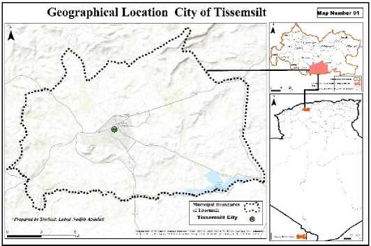
Source: National Office of Statistics (2018) + Researcher’s Data Processing

Tissemsilt, as a case in point in Figure 1, has garnered substantial attention from authorities, investors, and urban planners, given its strategic importance in regional development. Over the years, the city has transitioned from a relatively small settlement into a significant urban hub. The fundamental principle of urban planning and land-use management here revolves around safeguarding agricultural land from unregulated urban expansion. This approach aims to balance the need for housing and infrastructure with the imperative of maintaining environmental sustainability and preserving fertile land for agriculture. A robust urban development framework, which aligns with population needs, has been seen as a cornerstone for sustainable urban expansion. However, despite these planning efforts, Tissemsilt’s urban footprint has expanded at a rate surpassing population growth, with its total urbanized area reaching 3,125 km². By 2024, the city’s population is projected to reach 300,000 inhabitants, which brings to light a critical set of challenges. Urban sprawl, inadequate infrastructure, and uneven access to services remain pressing issues. While the city’s strategic importance has attracted investments and planning initiatives, the rapid rate of expansion calls for more adaptive and inclusive urban planning policies that anticipate future growth trends rather than reacting to them.
According to the most recent demographic data, Tissemsilt Province had a population of 362,229 inhabitants at the end of 2019, with a density of 115 inhabitants per km², classifying it as a moderately populated region. The urban population alone accounted for 188,176 inhabitants, or roughly 51.95% of the total. Notably, over 70% of the population is under the age of 30, indicating a predominantly youthful demographic structure that necessitates forward-looking policies in education, employment, and housing. The city’s primary urban centers—home to 241,677 residents—are complemented by secondary settlements (28,287 inhabitants) and dispersed rural areas (92,265 inhabitants), highlighting the diverse settlement patterns that contribute to Tissemsilt’s urban profile.
Tissemsilt’s urbanization has followed two distinct models: planned growth regulated under structured urban frameworks and unregulated expansion occurring mainly in peri-urban areas. The planned growth model has sought to provide structured housing developments, public services, and infrastructure that meet the city’s long-term objectives. By contrast, unregulated growth—marked by
informal settlements and piecemeal development—has created challenges in terms of resource allocation, infrastructure adequacy, and equitable access to public services. This dual approach to urbanization reveals the complexities of managing urban growth in a city where the need for expansion often outpaces the capacity of planning frameworks to keep up.
Fig.2. Dual Histogram and Frequency Polygon of Housing Units and Occupancy Rate in
Tissemsilt
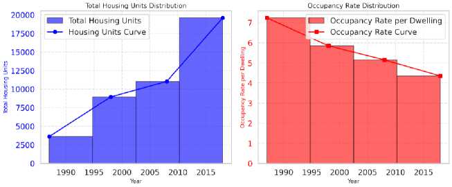
Source: National Office of Statistics (2018) + Researcher’s Data Processing
Between 1998 and 2008, Tissemsilt experienced significant demographic expansion, with the population growing from 52,451 inhabitants in 1998 to 66,084 in 2008, reflecting an average growth rate of 2.38% over the decade as showed in Figure 2. While such growth is a testament to the city’s increasing prominence, it also underscores the necessity for a cohesive urban planning strategy that can accommodate future demands. As the city continues to expand, challenges related to land-use management, housing adequacy, and public service distribution will require innovative solutions. This includes leveraging new technologies in urban planning, involving communities in decision-making processes, and ensuring that policies are flexible enough to adapt to rapidly changing urban realities. Moreover, the city’s housing stock has steadily increased over the decades, as illustrated in the table below. By 2018, Tissemsilt had 19,604 housing units, compared to just 3,622 in 1987. Over the same period, the occupancy rate per dwelling decreased from 7.24 persons per unit to 4.35 persons per unit, signaling an improvement in housing availability. However, this improvement does not entirely alleviate concerns over urban density and the adequacy of residential infrastructure. Instead, it highlights the ongoing challenge of balancing growth with the provision of quality housing, infrastructure, and public amenities that meet the needs of a growing population.
-
Fig. 3 . Residential Pattern in Tissemsilt City
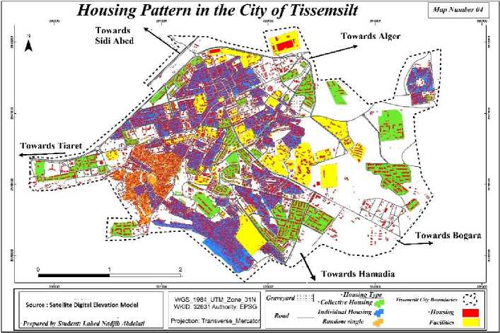
Source: National Office of Statistics (2018) + Researcher’s Data Processing
-
4 . Demographic and Economic Dynamics of Tissemsilt
-
4 .1 Population Growth and Age Distribution
-
The continuous increase in the housing stock as showed in Figure 3, coupled with fluctuating occupancy rates, paints a picture of a city in transition. While more people have access to housing, the rapid pace of urbanization places significant strain on Tissemsilt’s infrastructure, public services, and urban environment. This dynamic calls for targeted interventions in land-use planning, infrastructure investment, and spatial equity in the distribution of public services. By addressing these challenges, Tissemsilt can move toward a more sustainable urban future that maintains its regional importance while ensuring that its growing population benefits from equitable and efficient urban systems.
Table 1: Population and Growth Rates in Tissemsilt
|
Year |
1987 |
1998 |
2008 |
2012 |
|
Population |
34,131 |
61,155 |
75,197 |
84,289 |
|
Growth Rate (%) |
- |
9.9 |
8.31 |
11.8 |
Source: Tissemsilt Municipality Statistics Office, 2015
The demographic evolution of Tissemsilt has been marked by steady population growth over the years. As shown in Table 1, the population increased from 34,131 in 1987 to 84,289 in 2012, with fluctuating growth rates reaching a peak of 11.8% in 2012. This rapid expansion highlights the city's increasing urbanization and its growing role as a regional center.
Table 2: Age and Gender Distribution in Tissemsilt (2012)
|
Age Group |
Males (%) |
Males (Count) |
Fema les (%) |
Females (Count) |
|
0-15 years |
6.38 |
6,538 |
6.08 |
3,513 |
|
15-45 years |
26.60 |
22,446 |
26.22 |
22,193 |
|
45-65 years |
13.99 |
11,180 |
13.63 |
4,971 |
|
Over 65 years |
3.64 |
1,729 |
3.46 |
2,917 |
|
Total |
50.61 |
42,549 |
49.39 |
41,740 |
Source: Tissemsilt Municipality Statistics Office, 2015
A key characteristic of Tissemsilt’s population is its youthful demographic structure, with over 70% of residents under the age of 30. Table 2 presents the age and gender distribution for 2012, revealing a significant concentration of individuals in the 15-45 age group, which represents the active working population. This demographic trend necessitates targeted policies in education, employment, and housing to accommodate the increasing demands of a young and growing population.
-
4 .2 . Economic Structure and Employment Challenges
Table 3: Economic Structure of the Population in Tissemsilt (2012)
|
Category |
Count |
Percentage (%) |
|
Active Population |
35,992 |
42.75 |
|
Inactive Population |
17,554 |
20.85 |
|
Employed |
22,858 |
27.15 |
|
Unemployed |
7,787 |
9.24 |
Source: Tissemsilt Municipality Statistics Office, 2015
The economic composition of Tissemsilt reflects a moderate level of workforce participation, with an active population of 42.75% as shown in Table 3. However, unemployment remains a significant challenge, with a jobless rate of 9.24%, which underscores the need for stronger economic policies and job creation initiatives. The presence of a large inactive population (20.85%) indicates structural imbalances in labor market accessibility and economic opportunities.
-
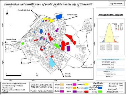
Fig. 4 . Commercial Establishments and Markets in Tissemsilt
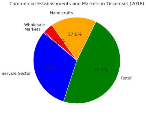
Source: Tissemsilt Municipality Statistics Office, 2015
-
5 . Urban and Spatial Development in Tissemsilt
-
5 .1 Population Density and Spatial Division
-
The city's commercial activities are highly concentrated in the retail and service sectors, accounting for over 78% of the total economic establishments in Figure 4. Despite this, wholesale trade and handicrafts remain underdeveloped, signaling untapped economic potential. Strengthening industrial, trade, and service infrastructure could play a vital role in fostering economic growth and reducing unemployment in the region.
Table 4: Spatial Division of Tissemsilt
|
Sector |
Area (ha) |
Housing Units |
Population |
Population Density (persons/ha) |
|
City Center |
156.4 |
3,188 |
20,803 |
133.01 |
|
Ain El- Borj |
356.3 |
1,668 |
9,830 |
27.58 |
|
El-Wiam |
258.8 |
3,488 |
20,683 |
79.91 |
|
D’harb |
371.1 |
4,178 |
32,973 |
88.85 |
Source: Tissemsilt Urban Development and Planning Report
Tissemsilt is divided into multiple urban sectors, each exhibiting distinct population densities and development characteristics (Table 4). The City Center remains the most densely populated area, with 133.01 persons per hectare, reflecting its role as the economic and administrative hub. In contrast, other sectors such as Ain El-Borj and El-Wiam exhibit lower population densities, indicating ongoing urban expansion into suburban and peri-urban zones.

Table 5: Population Growth Projections (2005-2026)
|
Year |
2005 |
2006 |
2011 |
2016 |
2026 |
|
Main Urban Area |
68,090 |
70,814 |
86,156 |
109,959 |
170,743 |
|
Municipality |
78,174 |
81,122 |
97,517 |
122,843 |
188,255 |
Source: National Office of Statistics, 2018
Population projections (Table 5) suggest that by 2026, the municipality’s population will reach 188,255 inhabitants, with the primary urban area expected to accommodate 170,743 residents. This anticipated growth underscores the urgent need for spatial planning, infrastructure investments, and equitable distribution of public services to support sustainable urban expansion.
Fig. 5 . Longitudinal Population Growth in Tissemsilt
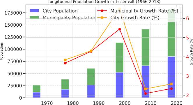
Year
Source: National Office of Statistics (2018) + Researcher’s Data Processing
The Figure 5 illustrates the longitudinal population growth in Tissemsilt from 1966 to 2018, highlighting both total population figures and growth rates for the city and municipality. The bar chart shows a consistent rise in population, with a notable surge between 1987 and 1998, where the municipality's population grew from 34,131 to 61,155, and the city's population more than doubled. This rapid growth suggests increased urbanization, migration, or infrastructural developments during that period. However, the line chart reveals fluctuations in growth rates, peaking at 6.49% for the city in 1998 before declining in subsequent decades. The drop in growth rates after 2008 suggests a stabilization phase, possibly due to shifts in economic conditions, migration trends, or housing limitations. While the overall population continues to rise, the declining growth rates indicate a need for sustainable urban planning to manage future expansion efficiently.
-
5 .2 Public Facilities and Green Spaces Distribution
Table 6: Distribution of Public Facilities Across Urban Sectors
|
Administrativ |
Healthcare |
Commercial |
Educational |
Cultural |
Touris |
Religious |
Total |
|
ector |
e |
m |
||||||
|
15 |
9 |
3 |
10 |
4 |
1 |
2 |
41 |
|
|
2 |
11 |
12 |
2 |
10 |
10 |
0 |
2 |
40 |
|
3 |
14 |
7 |
2 |
8 |
6 |
2 |
2 |
36 |
|
4 |
4 |
3 |
2 |
6 |
6 |
0 |
2 |
22 |
|
otal |
44 |
29 |
9 |
34 |
26 |
3 |
8 |
139 |
Source: 2008 Urban Development Plan
Public facilities in Tissemsilt are distributed unevenly across different urban sectors (Table 6). The city center and core urban areas have a higher concentration of administrative, healthcare, educational, and commercial establishments, whereas peripheral sectors lack adequate access to essential services. This spatial imbalance in public service distribution calls for strategic interventions to ensure equitable access and reduce disparities between central and outlying districts.
Table 7: Green Spaces and Recreational Facilities in Tissemsilt
|
Type |
Count |
Percentage (%) |
|
Green Spaces |
2 |
9.09 |
|
Playgrounds and Recreational Areas |
18 |
81.82 |
|
Public Squares |
2 |
9.09 |
|
Total |
22 |
100 |
Source: Department of Sports, 2018
Additionally, green spaces and recreational areas remain scarce (Table 7), with only two designated green spaces and 18 recreational areas. The limited availability of public spaces highlights the need for improved urban planning strategies that prioritize environmental sustainability and quality of life enhancements. Expanding green zones, playgrounds, and cultural centers will be essential for creating a more livable and well-balanced urban environment in Tissemsilt.
-
6. Urban Expansion and Infrastructure Development in Tissemsilt
-
6.1. Urban Expansion and Implementation of the Master Plan
-
The study of urban expansion in Tissemsilt employed the supervised classification technique to analyze the city's growth footprint over different periods. This method allowed researchers to track urban development patterns and the extent of built-up areas, offering insights into the spatial evolution of the city.
-
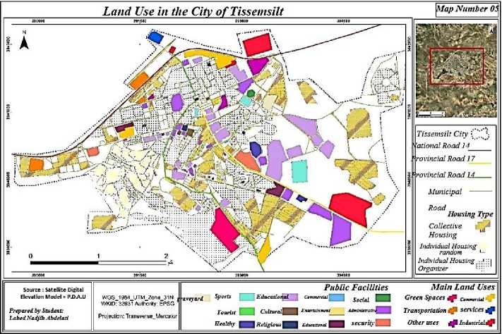
Fig. 6 . Land Use Patterns and Public Facilities Distribution in Tissemsilt
Source: National Office of Statistics (2018) + Researcher’s Data Processing
The Figure 6 shows the spatial organization of Tissemsilt through a clear depiction of its main land use categories and road networks. Residential zones (in light tones) occupy much of the central and peripheral areas, reflecting the city’s ongoing urban expansion. Public facilities—such as educational, health, and administrative buildings—are concentrated primarily in and around the urban core, suggesting a centralization of services that may challenge accessibility for outlying districts. Notable road corridors, including National and Provincial Roads, traverse the city and connect key sectors, fostering economic and social interaction. Commercial and industrial activities, displayed in darker hues, are dispersed but tend to cluster near major transportation routes, reflecting strategic placement for trade and logistics. Overall, the map highlights both the dense urban center and the more fragmented suburban and rural fringes, emphasizing the importance of balanced land use planning to enhance service accessibility, preserve agricultural land, and support sustainable urban growth.
-
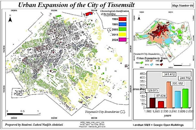
Fig.7. Urban Expansion of Tissemsilt City
Source: National Office of Statistics (2018) + Researcher’s Data Processing
This Figure shows the progressive growth of Tissemsilt’s built-up area over several key periods (1985, 1995, 2005, 2015, and projected 2024). Each color band highlights a different phase of urban development, illustrating how residential and commercial structures have extended outward from the city center to peripheral zones. An inset chart tracks the increasing population figures alongside the expanding footprint, underlining the link between demographic pressure and spatial sprawl. Notably, the green areas represent more established sections of the city, while recent (and future) expansions are marked in brighter hues. Overall, the figure emphasizes Tissemsilt’s rapid urbanization, underscoring the need for strategic planning to manage growth effectively and ensure balanced development across its evolving neighborhoods.
-
6.2. Housing Developments and Typologies in Tissemsilt
Table 8: Major Objectives and Implementation Status of the Urban Master Plan
|
Objective |
Implementation Status |
|
Preservation of agricultural land surrounding the city |
Not implemented |
|
Directing urban expansion towards peripheral clustered centers (Ain Loura, Ain El-Borj, etc.) |
Implemented |
|
Limited expansion feasibility in the west and southwest, while expansion in the east and northeast is more viable due to suitable topography |
Implemented, but at the cost of agricultural land |
|
Establishment of a passenger transport hub in accordance with national standards |
Implemented, but revised |
|
Improvement of roads and sidewalks in urban districts |
Partially implemented |
|
Renovation of 881 colonial-era housing units with partial renewal in the short term |
Partially implemented |
|
Rehabilitation of city entrances |
Implemented, but revised |
|
Identification of new water sources for potable supply |
Implemented |
|
Construction of a wastewater treatment plant |
Not implemented |
|
Rehabilitation of sewage systems, particularly for stormwater drainage in winter |
Partially implemented |
|
Provision of essential facilities for the 105-Housing Neighborhood, including a middle school, market, pharmacy, library, and green spaces |
Partially implemented |
Source: Directorate of Urban Planning, Architecture, and Construction, 2018 + Data Analysis by the Researcher
The Urban Master Plan for Tissemsilt outlined several key development objectives, yet their implementation has varied. Some measures have been fully realized, while others remain partially implemented or unaddressed. Table 8 provides a detailed breakdown of the major objectives and their implementation status. Notably, while urban expansion was directed towards peripheral clustered centers, the preservation of agricultural land was not achieved, indicating challenges in balancing urban growth with environmental sustainability. Similarly, critical infrastructure projects, such as the construction of a wastewater treatment plant, remain unimplemented, highlighting gaps in urban service provision. The disparities in urbanization trends across Algeria have significantly impacted the structural development of cities, with northern urban centers developing at a faster rate than smaller, isolated cities like Tissemsilt. This imbalance has exacerbated spatial inequalities, reinforcing the need for comprehensive planning that ensures equitable access to urban services and infrastructure.
Table 9: Pre-Master Plan Housing Development Projects in Tissemsilt
|
Location |
Housing Type |
nits |
Implementation Status (2004) |
|
El-Wiam 1 |
Collective |
88 |
Completed |
|
Hamadia Road |
Collective |
38 |
Completed |
|
- |
Collective |
10 |
Not initiated |
|
- |
Individual |
65 |
Not initiated |
|
Bougara Road |
Collective |
18 |
Completed |
|
- |
Collective |
8 |
Under construction |
|
- |
Semi-collective |
26 |
Completed |
|
- |
Individual |
66 |
Ongoing construction |
|
Hamadia (La Rocade) |
Collective |
8 |
Under construction |
|
- |
Collective |
0 |
Not initiated |
|
Marja |
Collective |
00 |
Completed |
|
- |
Collective |
02 |
Under construction |
|
- |
Individual |
25 |
Completed |
|
Ain El-Borj |
Collective |
00 |
Not initiated |
|
- |
Individual |
07 |
Completed |
|
Algeria Road |
Collective |
90 |
Under construction |
|
City Center |
Individual |
58 |
Completed |
|
105-Housing Neighborhood |
Individual |
22 |
Completed |
|
Hospital Road |
Individual |
5 |
Completed |
|
Nawadir |
Individual |
46 |
Ongoing construction |
|
Sid El-Houari (D’harb) |
Individual |
96 |
Not initiated |
|
Ain Loura |
Individual |
Not initiated |
|
01 |
|||
|
Dallas |
Individual |
54 |
Completed |
Source: Directorate of Urban Planning, Architecture, and Construction, 2018 + Data Analysis by the Researcher
The evolution of urban expansion in Tissemsilt has been closely linked to its housing developments. Table 9 presents a summary of housing projects planned before the revision of the Urban Master Plan, detailing their implementation status. Several projects, particularly in El-Wiam, Hamadia Road, and Bougara Road, were successfully completed, whereas others remain under construction or uninitiated, reflecting delays in urban planning execution.
The diversity in housing typologies in Tissemsilt reflects the socio-economic conditions and historical influences shaping the city’s residential landscape:
-
1 .European-style Individual Housing – Characterized by a grid-like layout, built with brick and stone, featuring ceramic tile roofs and open courtyards. Predominantly found along National Road No. 14 and in the city center.
-
2 .Traditional Individual Housing – Constructed from stone and cement, featuring a shared groundfloor layout with tiled roofs. Typically located behind the European-style housing sector.
-
3 .Modern Individual Housing – Emerged in the 1980s, typically two to three stories high, with concrete slab roofs.
-
4.I nformal Individual Housing – Found in southwestern districts, characterized by irregular layouts and varying construction styles.
-
6.3 . Spatial Distribution of Public Facilities and Infrastructure
Additionally, collective housing consists of apartment buildings ranging from ground floor + three floors to four floors, with varying apartment sizes. This diversity in housing types reflects different urbanization waves, economic factors, and policy interventions over time.
The spatial distribution of public facilities in Tissemsilt has been a fundamental concern in urban geography, influencing both urban structure and accessibility. The placement of essential infrastructure plays a key role in shaping urban equity and service availability.
Tissemsilt functions as a regional hub for healthcare, education, and administrative services, with public facilities categorized into two levels based on their influence:
-
• City-wide level: Facilities catering to daily needs and essential services, including healthcare, administrative offices, and educational institutions.
-
• Provincial level: Larger-scale infrastructure, such as the administrative district, commercial complexes, and central markets, serving both Tissemsilt and surrounding settlements.
-
7. Conclusion
However, as indicated in urban planning reports, the spatial allocation of public facilities is highly uneven. Most facilities are concentrated in the city center and northeastern sectors, leading to accessibility challenges for residents in peripheral and rural areas. This underscores the need for strategic interventions to decentralize public services and improve urban infrastructure in underserved districts.
By addressing these challenges—implementing master plan objectives, improving housing policies, and enhancing public service distribution—Tissemsilt can foster sustainable urban expansion and balanced regional development.
The study of urban expansion and public facility distribution in Tissemsilt reveals that the city's spatial growth has been characterized by imbalanced infrastructure deployment, unstructured urban sprawl, and disparities in accessibility to essential services. The findings highlight that while urban expansion has been driven by rapid population growth and economic transitions, the unequal distribution of public facilities has created functional imbalances, concentrating key services in central districts while neglecting peripheral and emerging urban areas. This uneven spatial development has led to challenges in service accessibility, land-use efficiency, and urban mobility, ultimately affecting the city’s livability and long-term sustainability.
Moreover, the analysis indicates that existing urban planning frameworks have struggled to keep pace with Tissemsilt’s rapid expansion. While strategic planning efforts have sought to direct urban growth through clustered peripheral expansion and infrastructure investment, key objectives such as the preservation of agricultural land and the implementation of wastewater treatment facilities remain unfulfilled. Additionally, the housing sector presents a mix of formal and informal developments, reflecting socio-economic inequalities and inconsistencies in regulatory enforcement. The lack of green spaces, recreational areas, and integrated transport systems further exacerbates urban inefficiencies, highlighting the need for comprehensive spatial planning reforms.
To achieve a more balanced and sustainable urban future, Tissemsilt must adopt adaptive urban planning strategies that prioritize equitable distribution of public services, improved infrastructure, and inclusive governance mechanisms. By integrating geographic information systems (GIS), community participation, and data-driven policy frameworks, urban planning can transition towards a more flexible and responsive approach, ensuring that infrastructure development aligns with demographic shifts and socio-economic needs. Only through strategic, sustainable, and inclusive planning measures can Tissemsilt overcome its current urban challenges and foster a more cohesive, accessible, and well-structured urban environment for its growing population.
