The Impact of Relief, Geological, and Geomorphological Structure on the Formation of Forest Ecosystems: A Case Study of Zangilan and Gubadli Districts, Azerbaijan

Автор: Aslanova K.
Журнал: Бюллетень науки и практики @bulletennauki
Рубрика: Естественные науки
Статья в выпуске: 6 т.12, 2026 года.
Бесплатный доступ
The article studies the influence of relief, geological structure, and geomorphological factors on the formation of forest ecosystems on the example of the Zangilan and Gubadli regions of Azerbaijan. Remote sensing (decoding of satellite images), mathematical-statistical, and comparative analysis methods were used during the study. As a result of the analyses, it was determined that the altitudinal zones of the territory (mainly 400–1200 m), the slope inclination, and vernalization are the main factors directly regulating the species composition and density of the vegetation cover. In particular, the Topographic Wetness Index (TWI) and the slope degrees have determined the zones of soil erosion and moisture accumulation. The complexity of the geological structure — its diversity from Jurassic and Cretaceous sediments to volcanogenic rocks — affects the processes of soil formation and, as a result, the structure of forests. The results of the study are of significant scientific and practical importance in planning measures for the ecological restoration of the region, the establishment of forest belts, and the protection of soil from erosion.
Geomorphology, forest ecosystem, TWI index, geological structure, digital elevation model
Короткий адрес: https://sciup.org/14138227
IDR: 14138227 | УДК: 502.3+528.8+630+911 | DOI: 10.33619/2414-2948/127/17
Влияние рельефа, геологического и геоморфологического строения на формирование лесных экосистем: на примере Зангиланского и Губадлинского районов Азербайджана
Исследуется влияние рельефа, геологической структуры и геоморфологических факторов на формирование лесных экосистем на примере Зангиланского и Губадлиского регионов Азербайджана. В ходе исследования использовались методы дистанционного зондирования (декодирование спутниковых снимков), математико-статистического и сравнительного анализа. В результате анализа было установлено, что высотные зоны территории (в основном 400–1200 м), уклон склона и яровизация являются основными факторами, непосредственно регулирующими видовой состав и плотность растительного покрова. В частности, топографический индекс влажности (ТВИ) и уклон склона определили зоны почвенной эрозии и накопления влаги. Сложность геологической структуры — ее разнообразие от юрских и меловых отложений до вулканогенных пород — влияет на процессы почвообразования и, как следствие, на структуру лесов. Результаты исследования имеют важное научное и практическое значение при планировании мероприятий по экологической реставрации региона, созданию лесопоясываний и защите почв от эрозии.
Текст научной статьи The Impact of Relief, Geological, and Geomorphological Structure on the Formation of Forest Ecosystems: A Case Study of Zangilan and Gubadli Districts, Azerbaijan
Бюллетень науки и практики / Bulletin of Science and Practice
UDC 502.3+528.8+630+911
Forest ecosystems, being an important component of the biosphere, play an indispensable role in preserving biodiversity, regulating water balance and maintaining the ecological stability of the landscape [4].
The formation, species composition and distribution of forest cover in the territory depend on the interaction of a number of natural and geographical factors [10].
Among these factors, relief, geological structure and geomorphological features form the fundamental basis determining the structure of vegetation cover [9].
Zangilan and Gubadli regions, located in the southwestern part of Azerbaijan, are characterized by a complex orographic structure and a diverse geological history [1].
These territories, covering the southeastern end of the Lesser Caucasus, are distinguished by their location in a sharp transition zone of both mountainous and plain relief forms [2].
The height differences of the relief, the inclination and exposure of the slopes lead to an uneven distribution of solar radiation and precipitation, which directly determines the microclimatic conditions and the differentiation of forest types in vertical zonation [3, 5].
The complex geological structure of the region, the presence of rocks and sediments of different periods have a direct impact on soil formation processes and the development of the root system of vegetation [7, 8].
In this regard, scientific analysis of the geomorphological framework and lithological characteristics of rocks is essential to assess the current state of forest ecosystems and predict their future development prospects [6].
The main purpose of this study is to analyze the impact of morphological elements of the relief (height, slope, TWI index, etc.) on the formation and distribution of forests using modern methods, and to determine the role of geomorphological factors in the stability of ecosystems, using the example of Zangilan and Gubadli regions.
Material and methods
During the research, we used both traditional and modern methods. During the research, we preferred to use field research and decoding of remote sensing materials. At the same time, we also used mathematical-statistical, comparative, and historical methods. We analyzed the morphological elements of the relief by decoding satellite images.
Resuld and discussion
The study area is located at the southeastern end of the Lesser Caucasus valleys. The area borders Lachin to the north, Hadrut to the northeast, Jabrayil to the east, Iran to the south, and Armenia to the west (Figure 1).
The geological development of the area is complex. To analyze the geological structure, we have prepared a geological map of the area (Figure 2).
The Bergushad range (Susan Mountain, 1304 m), which enters the territory from the northwest of Zangilan, descends and forms the Ag Oyug inclined plain (height 400-600 m) between Bazarchay and Okchuchay. In the northeast, the slopes of the Karabakh range descending towards the Araz and Hakari rivers pass into the hilly Gayan (Gayan) plain. In the west, the eastern edge of the Mehri (Mehri-Güney) range is Bartaz Mountain (2270 m). The height of the relief is an important factor for the formation and development of forests. As the altitude increases, the temperature and atmospheric pressure decrease, which changes the bioclimatic conditions of plants. Broad-leaved and mixed forests are usually formed at low and medium altitudes, while coniferous forests predominate in high mountainous zones due to the harsh climate. Altitude also affects the soil type and water regime, which determines the structure and species composition of forests. For this purpose, we have compiled an altitude map of the area and then conducted analyses.
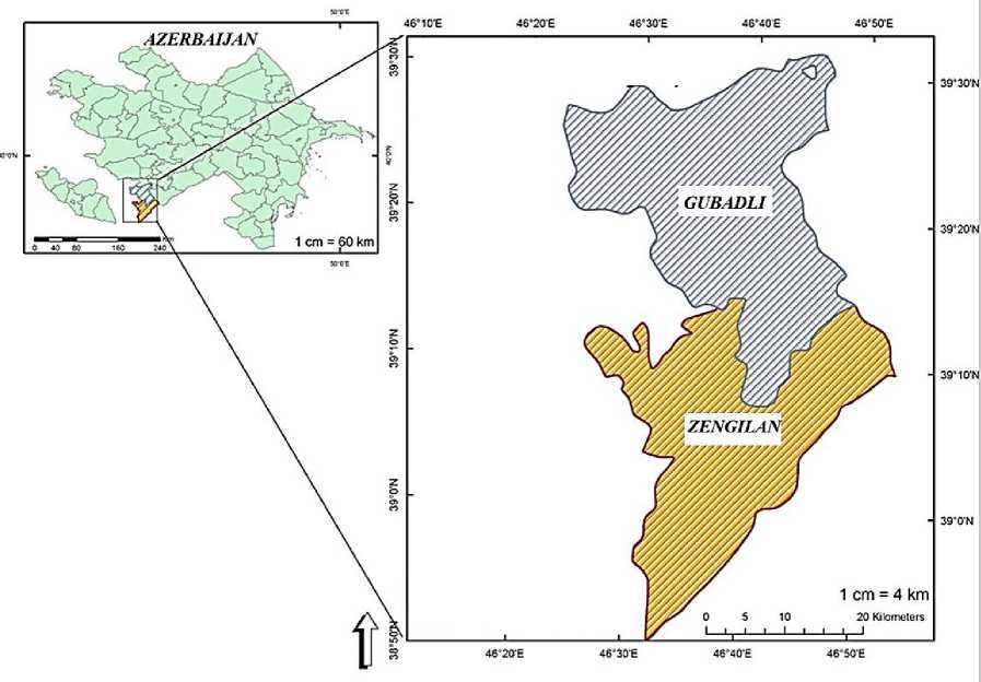
Figure 1. Location of the study area
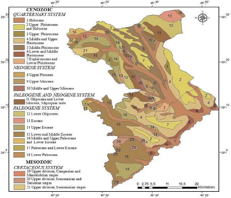
Figure 2. Geological map
The largest part of the territory of Zangilan district is located at an altitude of 401-800 m (40904.98 ha). It covers an area of 14555.04 ha at an altitude of251-400 m, 11921.86 ha at an altitude of 801-1200 m, 2726.96 ha at an altitude of 1201-1600 m, and 844.15 ha at an altitude of 1600-2251 m. Thus, the district is mainly concentrated at low and medium altitudes (Figure 3).
The distribution of Gubadli district by altitude is as follows: the largest part of the district is located at an altitude of 401-800 m (42417.71 ha). It covers an area of 2793.01 ha at an altitude of 322-400 m, 24453.45 ha at an altitude of 801-1200 m, 7407.45 ha at an altitude of 1201-1600 m, and 815.62 ha at an altitude of 1600-2003 m. Thus, the region is mainly concentrated at low and medium altitudes (Figure 3).
815,6233
Gubadli Zengilan
844,146
7407,4529
2726,9616
24453,4519
11921,8647
42417,7085
40904,9773
2793,0142
14555,041
-
Figure 3. Relief height in Gubadli and Zangilan regions, ha
The slope of the relief is directly related to the movement of water and the susceptibility of the soil to erosion. In steeply sloping areas, the thinness of the soil layer and the rapid flow of water limit the access of plants to water and nutrients, therefore, forests in these zones are sparser and less diverse. In gently sloping and flat areas, since the soil is deeper and more water-retaining, forests are formed more densely and of various types. For this purpose, we have compiled a slope map of the study area, and then conducted analyses. The distribution of Zangilan district by slope is as follows: the largest part of the district consists of areas with a slope of 0-10° (34946.57 ha), areas with a slope of 10-20° are 21293.75 ha, areas with a slope of20-30° are 1008.49 ha, areas with a slope of 30-40° are 3509.01 ha, and areas with a slope of 40° and higher are 625.05 ha. Thus, the district consists mainly of low-slope areas (Figure 4).
The distribution of Gubadli district by slope is as follows: the largest part of the district consists of areas with a slope of 0-10° (35889.17 ha). Areas with a slope of 10-20° are 2765.19 ha, areas with a slope of 20-30° are 11361.37 ha, areas with a slope of 30-40° are 2338.63 ha, and areas with a slope of 40° and higher are 229.60 ha. Thus, the region consists mainly of low-slope areas (Figure 4).
The slope determines the light regime and microclimate of the relief. Since sunlight is abundant on the southern and southwestern slopes, the photosynthesis activity of plants is enhanced and forests develop more densely. Since humidity is high and sunlight is weak on the northern and northeastern slopes, the vegetation cover is sparser and richer in coniferous species. Thus, the height, slope and slope of the relief together have a significant impact on the composition, structure and distribution of forests. For this purpose, we have compiled a slope map of the study area, and then conducted analyses. Distribution of slope in Zangilan district: The largest part of the district consists of plain areas (11731.13 ha). The area of the region is 8399.27 ha in the North, 9279.76 ha in the North-East, 8985.84 ha in the East, 8522.99 ha in the South-East, 7940.06 ha in the South, 6451.27 ha in the
South-West, 5202.51 ha in the West, and 3946.41 ha in the North-West. The region consists mainly of plains and slopes of various directions (Figure 4).
229,6039
625,0505 Gubadli Zengilan
2338,6259
3509,0056
11361,3656
1008,48751
2765,1947
21293,7508
35889,1662 34946,5733
-
Figure 4. Slope inclination in Gubadli and Zangilan districts, in ha
Distribution of pastures in the Gubadli region: the largest area is in the plain (13842.29 ha). It covers an area of 8141.77 ha in the North, 8675.41 ha in the North-East, 8492.90 ha in the East, 8751.10 ha in the South-East, 8589.29 ha in the South, 7817.67 ha in the South-West, 7144.59 ha in the West, and 6015.69 ha in the North-West. The region is mainly characterized by plains and moderate slopes (Figure 5).
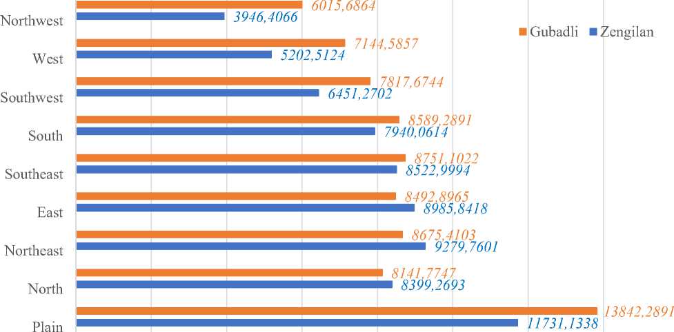
Figure 5. Slope exposure in Gubadli and Zangilan regions, in ha
Topographic Wetness Index (TWI) is a geomorphological indicator that assesses the moisture accumulation potential of the relief. This index determines the probability of water accumulation in the soil based on the slope inclination and the area of accumulation of water flowing from the upper part. High TWI values indicate areas where water accumulates more and the soil is moist, while low values indicate dry areas with good drainage. TWI is widely used in studying soil moisture, vegetation distribution and erosion risk. For this purpose, we have compiled a Topographic Wetness Index map of the area (Figure 6).
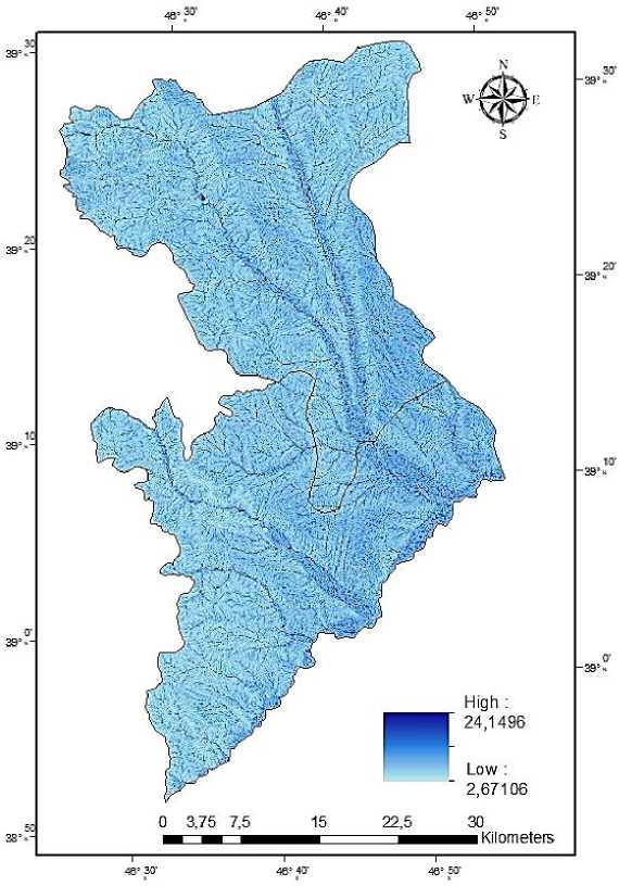
Figure 6. Topographic Humidity Index
The orography of the study area is complex, fragmented and has a sharp relief. Based on the conducted geomorphological and geological studies, the region can be divided into three zones: 1. Denudation mid-mountain zone. 2. Foothills (low mountains) 30 m. 3. Deluvial foothills sloping plain zone. Denudation mid-mountain zone. It covers the southeastern slopes of the Bargushad Mountains and the southwestern slopes of the Karabakh Range. The highest point in this zone is located at 1704 m. Here, the southern slope is more sharply dissected than the northern slopes. Natural factors play a more important role in this dissection. The Bargushad Mountains descend sharply in the south and northeast directions. While the northern direction of these mountains is covered with forest, the southern direction has forestless, phrygana-type vegetation. Therefore, the southern direction has undergone a sharp process of fragmentation, especially in the southeastern foothills of the Bargushad Mountains. In addition, as a result of the influence of erosion and weathering processes, uniform rocks have been formed in the territory of the Gubadli region.
The largest branch of the Karabakh Mountains within the region is considered to be Mount Yalyurd. The highest point of this mountain reaches 1410 m. The Yalyurd branch gradually descends to the south and forms the Qizildas rock massif. This massif is composed of Cretaceous sediments. In many places, limestones protrude to the surface. The southern continuation of the Karabakh mountain range descends from it to the south, where the Siyarat mountain descends. These areas have formed a complex relief form consisting of deep valleys dissected by the left branches of the Hakari
River. Blackthorn bushes and sparse, low-growing juniper trees dominate in these valleys. The middle mountainous zone descends and is replaced by a foothill or low-mountain zone.
Foothill (low-mountain) zone. This zone extends from north to south. Forest cover is almost non-existent here. Blackthorn bushes, etc., are found occasionally as low-growing trees. The highest peaks of the foothill zone are located in the northern and western parts of the region, descending towards the sloping plain. Along with dissected areas, there are also plain areas in the zone.
“U” - shaped valleys dominate the relief of the foothill zone. Such ravines and goblets are most widespread on the terraces of rivers. Most of these valleys have steep slopes. Such steep slopes are most often found near Muradkhanli-Farajan. The poor development of vegetation here, the absence of water-collecting relief forms, leads to the occurrence of silt phenomena, as a result of which agriculture (gravel fills the fields) and transport are damaged. Porphyry rocks are most widespread in this zone.
Deluvial foothill sloping plain zone. The foothill sloping plain zone is wavy and is cut by ravines and ravines in different directions. Examples of this include the Kuru dere, Meydan dere, Gobu dere, Tumas dere, etc. Small hills are found on the plain, which also slightly disrupt the slope of the relief. The sloping plain descends steeply to the Hakari and Bargushad river valleys in some places, and gradually in others. This zone is covered by deluvial, alluvial and alluvial-prolluvial deposits. The Gayan plain is covered by volcanogenic sediments and alluvial-prolluvial deposits with a thickness of 160–170 m.
The Yazy plateau has a large area with a high plateau and continues to the village of Khanlig. The plateau's height in the north is 600–700 meters. The plateau expands near the village of Hamzali and is replaced by fragile and soft stony-rocky parts downwards.
The Gorus stratum is composed of an alternation of large and small clastic materials, tuff breccia, tuff and clay. The Gorus stratum is the southern plume of the Işıklı volcano and was formed from its eruption materials.
The alluvial meadow formed on the materials brought by the Hakari and Bargushad rivers expands from north to south.
In the plain, volcanogenic materials decrease compared to the mountainous part, and instead, river valleys increase.
The area has a complex geological structure. Thus, all rocks starting from the Jurassic sediments to the Quaternary sediments are distributed.
The area is geologically divided into two parts. The first covers the mountainous area. This area is covered with tertiary sedimentary products. These are exposed in the upper and middle reaches of the Hakari, Okchuchay, and Bargushad rivers. The areas covered with secondary and tertiary sediments occupy a small area in the Gubadli region of the study area.
Intrusive rocks of volcanic origin are widespread in the southeastern part of the mountainous area, which are composed of porphyry, basalt, granodiorite, and diorite.
Considering the diversity of rocks and the concentration of erosion materials in different areas depending on the relief, the following soil-forming rocks were found to be widespread: alluvial, delluvial, prolluvial sediments.
In the territory of the Gubadli region, alluvial sediments have developed in a relatively small area of the relief in the front high parts of the Karabakh and Bargushad mountains.
Delluvial sediments cover a large part of the study area in terms of volume. The soils formed in these sediments have very little skeletal content. They are heavy and light clayey in terms of their mechanical composition.
Prolluvial sediments are most common in valleys and ravines, and alluvial sediments are widespread in the ancient and modern terraces of the Hakari and Bargushad rivers.
Conclusion
The study of the impact of relief, geological and geomorphological factors on the formation of forest ecosystems on the example of the Zangilan and Gubadli regions gives rise to the following conclusions:
-
1. The relief of both regions is mainly concentrated in low and medium mountainous zones (400-1200 m). This altitude range creates favorable bioclimatic conditions for the development of broad-leaved forests and shrub plants in the region. As the altitude increases, the decrease in temperature and changes in humidity lead to direct differentiation in the structure of the vegetation cover.
-
2. The study shows that although most of the territory has a slope of 0-20°, on steep slopes (3040° and more) the thinness of the soil layer and intensive surface washing lead to thinning of the forest cover. Especially in the Gubadli region, in inclined areas with weak vegetation cover, flood and erosion processes are activated.
-
3. The slope of the slopes plays a decisive role in the formation of the microclimate. The northern and northeastern slopes are more humid, so they are suitable for forest restoration. In the example of the Bargushad range, it can be seen that while the northern slopes are covered with dense forests, the southern slopes are drier due to the influence of solar radiation and xerophytic (phrygana-type) plants dominate here.
-
4. The complex geological structure of the area (rocks from the Jurassic to the Quaternary period) and the distribution of sediments of various origins (eluvial, delluvial, alluvial) affect soil fertility and water regime. Topographic Wetness Index (TWI) analysis shows that the depressions of the relief and river terraces create conditions for the creation of more stable ecosystems by forestshrub plants due to the accumulation of moisture.
-
5. In general, when planning measures for the restoration and protection of forest ecosystems in the Zangilan and Gubadli regions, the degree of fragmentation of the relief, the inclination of the slopes and the potential for moisture accumulation must be taken into account.
