The incipient Neolithic of the Kurile islands: the culture of long barrows

Author: Grishchenko V.A., Pashentsev P.A., Vasilevski A.A.
Journal: Archaeology, Ethnology & Anthropology of Eurasia @journal-aeae-en
Section: Paleoenvironment, the stone age
Article in issue: 2 т.50, 2022.
Free access
This study introduces a recently discovered Neolithic culture of insular Northeast Asia. The initial stage of the Kurile Neolithic is described using findings from the 2019–2020 excavations at Kitovyi-2 and -4 on Iturup Island, the Greater Kurile Chain, Sakhalin Region. Several types of Neolithic feature were first revealed on the Kuriles by excavating large areas. The site includes dwellings mostly of two types–terranean with wooden frames that are not dug into the ground, and semisubterranean. Artifacts include linear-relief pottery and retouched bifacial stone tools on flakes and entire singularities, processed by advanced polishing. For the first time on the Kuriles, long barrows encircled by basalt plates along the perimeter were detected. These structures with evidently non-utilitarian enclosures made of plates, tentatively identified as places for cremation burials and funerary rites, indicate symbolic behavior. On the basis of this key criterion, we propose to attribute Kitovyi-2 and -4 to the culture of long barrows. Stratigraphic evidence, supported by radiocarbon analysis, allows us to establish the initial stage of the Kurile Neolithic, dating to 13.0–8.5 cal ka BP.
Kurile Islands, incipient Neolithic, long barrows, ritual behavior, linear-relief pottery
Short address: https://sciup.org/145146784
IDR: 145146784 | DOI: 10.17746/1563-0110.2022.50.2.003-012
Text of the scientific article The incipient Neolithic of the Kurile islands: the culture of long barrows
Archaeological studies on the Kurile Archipelago were carried out by researchers from Russia, Japan, America, and Europe, and have been going on for almost a century and a half (Milne, 1882; Kono, 1905; Torii, 1919; Schnell, 1932; Chubarova, 1960; Golubev, 1964, 1972). However, owing to the inaccessibility of the islands, the studies have had a sporadic character. The situation improved to some extent in the last quarter of the 20th century, with the participation of the USSR Geographical Society in organizing the study of Russian settlements of the Modern Age (Shubin, 1994). But the goals of the rest of the research projects still followed the patterns of the initial stage of the studies: survey of the coast, surface collection of artifacts, exploratory excavations, compilation of archaeological maps, and formation of collections (Steshenko, Gladyshev, 1977; Knorozov, Spevakovsky, Taksami, 1984; Prokofiev, 1986, 1995, 2001, 2003; Zaitseva et al., 1989).
The Kurile Archipelago still remained terra incognita as compared to achievements in world and domestic archaeology. The first decade of the 21st century was marked by a comprehensive international program of collaboration between Washington State University (USA) and a number of scientific institutions in Russia. The series of derived radiocarbon dates and arrays of scientific data provided the researchers
with the possibility to carry out analyses based on an informational ecological-archaeological approach, which was conceptually new for the archipelago (Fitzhugh et al., 2002, 2004; Phillips, Speakman, 2009). In the 2000– 2010s, regional studies in the country intensified, owing to the streamlining of rescue archaeology programs. New hypotheses and chronological classifications have been proposed, the approximate boundaries of the Stone Age, Late Bronze to Early Iron Ages, and Middle Ages have been determined, and a geographical atlas showing locations of archaeological objects has been compiled (Atlas…, 2009; Vasilevski, Grishchenko, Orlova, 2010; Shubina, 2012; Samarin, Shubina, 2013; Vasilevski, Potapova, 2017). On the basis of the surface collections and radiocarbon dates derived from the Yankito-1 samples, the hypothesis on the Early Neolithic on the Kurile Islands has been proposed (Yanshina, Andreeva, Pantyukhina, 2008; Yanshina, Kuzmin, 2010; Kuzmin et al., 2012). From the standpoint of modern knowledge, these works, which were not backed up by thorough field procedures (i.e. planigraphic, stratigraphic observations and typological series), are perceived as preliminary, which, however, corresponds to the pioneering nature of archaeological research on the archipelago in the 19th and 20th centuries.
A systemic progress occurred in 2016–2020, when seven multilayered sites of Rybaki-2, Kurilsk-6, and Kitovyi-2–6, with a total area of 11,364 m2, dated to the Stone Age, Late Bronze to Early Iron Ages, and Middle Ages, were studied on Iturup Island during three seasons. The derived data make it possible to determine,
reasonably and with sufficiently high accuracy, the content, chronological boundaries, and characteristics of the three above-mentioned epochs and their stages, as well as to introduce the concepts of the “Incipient Neolithic of the Kurile Islands” and the “culture of long barrows”. This article is the first in a series scheduled for publication. The goal is to describe the stratified materials from the ongoing excavations in the Kurile Islands and to discuss a new concept of archipelago archaeology. This paper introduces a new Neolithic culture and substantiates the initial stage of the Neolithic of the Kurile Islands.
The objects of archaeological heritage— settlement sites of Kitovyi-2 and -4
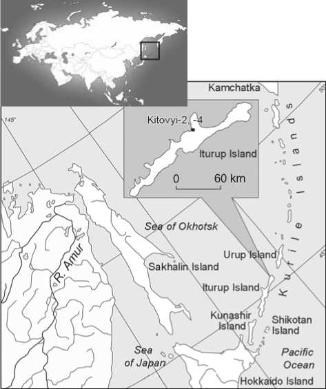
The sites are located on the Sea of Okhotsk coast of Iturup Island (the Greater Kurile Chain), on the borderline between the village of Kitovyi and the city of Kurilsk. The sites are located in the nearest vicinity to each other on a volcanic plateau on the coast of Kitovyi Bay (Fig. 1, 2). The area is dominated by the Holocene stratovolcano Bogdan Khmelnitsky, 1585 m high; within a radius of 10–30 km, a group of other active volcanoes (Baransky, Ivan Grozny, Machekha, and others) is situated. The described plateau is a gently sloping plain, ending in a 20 m high abrasion ledge facing the bay. The areas containing the sites were previously known as the locations of surface collection of artifacts. In 2014–2019, during the historically and culturally expert works under the construction project, cultural layers were revealed at the both sites. In 2019 and 2020 rescue excavations of the settlements of Kitovyi-2 (1014 m2) and -4 (4071 m2) were carried out. As a result, in the lower layers of both the sites, dwellings and ritual objects from the Stone Age were found, with no parallels either on the neighboring islands, or on Hokkaido and Sakhalin. Since the settlements are adjacent to one another and the archaeological complexes from their lower horizons are stratigraphically, typologically, and chronologically (according to the results of radiocarbon dating) well correlated, in this article they are considered together.
Stratigraphy. The coastal part of the plateau containing both sites is characterized by the following features, revealed by excavations in 2019–2020. The sequence of loose deposits was formed during the transformation of parent volcanogenic rocks by subaerial processes, with the active participation of diluvium drift, and consists of a sequence of sandy-loamy sediments.
Fig. 1. Location of the archaeological sites of Kitovyi-2 and -4.
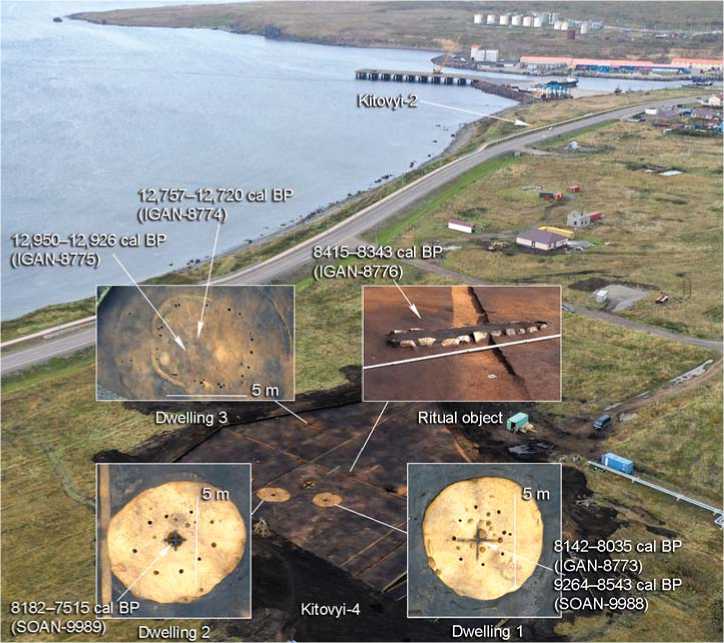
Fig. 2. Objects identified in excavation 1 of 2020 at Kitovyi-4 (south view).
Characteristic horizontal layering, granulometric composition, and the predominance of dark tones due to soot pigment in the color range of loose deposits are typical of both excavation areas. Dense sandy loams, abundantly saturated with small pyroclastic inclusions, alternately in light and dark colors, mark episodes of active volcanic activity in the Holocene.
In the upper horizons at the settlement of Kitovyi-2, medieval artifacts were found, which had been redeposited in a layered sequence of volcanogenic deposits. The underlying light loam layer, intensely colored with soot pigment of volcanic origin, does not contain signs of human presence. At Kitovyi-4, the stratigraphic situation is similar: solitary finds from recent periods in the upper layers of the sequence are separated from the Neolithic objects by an archaeologically sterile layer.
The dwelling-remains identified in horizon 4 at both sites were filled with dense sandy loam varying in color from black to light brown, interleaved with carbonized lenses. The underlying layers of dense sandy loam and still lower heavy yellow loam cover the bedrock and form the base of loose deposits. The loam layers are archaeologically sterile and have been taken as the bottom of the excavations. The objects of various ages in horizons 1 and 4 are mutually isolated, making it possible to consider the complexes of the Stone Age and the Middle Ages identified on the plateau as the objects in situ separated stratigraphically.
Dwellings. A dwelling designated as number 5 (Fig. 3) was identified in horizon 4, excavation area 1 of the Kitovyi-2 settlement (2019). After cleaning, at the bottom of the layer of dense sooty sandy loam, a rounded dwelling depression was revealed, 6.5 m in diameter and up to 0.4 m deep. The floor was even, without gradients, dense, composed of bright yellow loam. In the center, a hearth was noted—a rounded pit, 1.0 m in diameter and 0.2 m deep. Barrier stones (pebbles and boulders) serving as heat accumulators were found in its filling. The trampled floor and the smeared coals of the hearth indicate the northeast exit from the dwelling, in the direction opposite to the sea winds. Five concentric rows of pole holes were noted within the dwelling depression: three between the walls and the center; one in the center, remaining from powerful supporting poles surrounding the hearth; and one more row of shallow, elongated pits under the walls—these are traces of placement of inclined framerafters. The identified system suggests the tent-roof of a semi-dugout (Fig. 3). The task of the construction was to maintain the stability of the dwelling on the open seaside plateau, with the hurricane winds and extreme snow-load typical of the Kurile Islands.
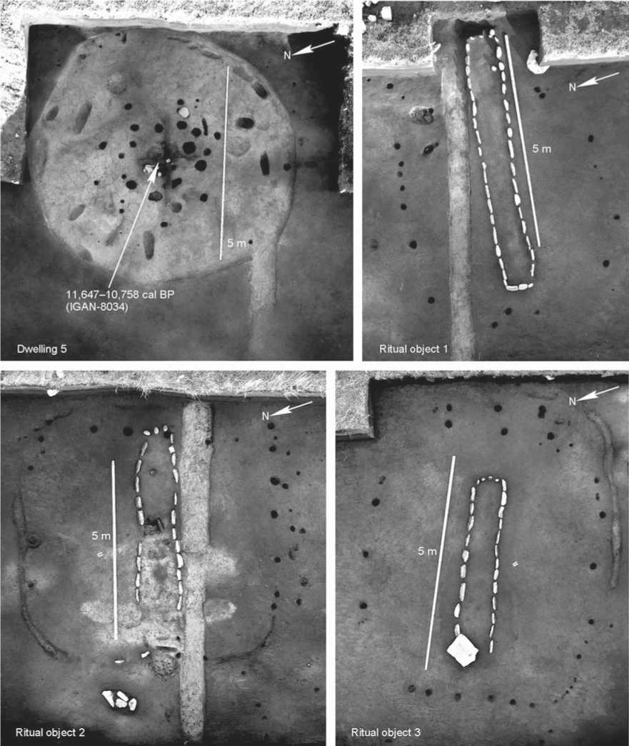
Fig. 3. Dwelling and ritual structures in excavation 1 of 2019 at Kitovyi-2.
In the lower layers of the excavation 1 at Kitovyi-4, three semisubterranean (1 and 2) and terranean (3) dwellings were cleared (see Fig. 2). The dwellings are similar in shape and size. Dwelling 1 rested on a rounded depression, 0.5 m deep and 6.3 m in diameter; dwelling 2 on an oval-shaped depression, 7.8 × 6.6 m in size, and 0.4–0.6 m deep. Both are dug into a layer of dense, dark gray sandy loam and go through the sooty layer of volcanic origin, reaching dense yellow loam. The ancient builders dispersed soil heaps along the edges of the dwelling depression, forming a banking. The floor in both dwellings is gently sloping from the walls to the center. Clusters of artifacts were found under the banking of dwelling 1. Hence, dwelling 1 was built later than dwelling 2.
In dwelling 1, 24 pits from vertical poles were noted on the floor. The pits’ diameter is 0.2–0.3 m; the average depth is 0.25 m. Five grooves up to 0.25 m deep and up to 0.45 m wide were found along the walls. Additional six grooves up to 0.25 m deep were noted on the ledge- shoulder along the margins of the dwelling depression. The configuration of pits and grooves suggests the tentroof of the dwelling, which fits geometrically into a circle. The rafters rested against holes in the walls and were tied to a frame that united the poles around the hearth in the center. Thus, the lower hanging edges of the roof (eaves) rested against the grooves and pits on the ledge-shoulder. The walls of the frame fixing the wooden structure were supported by the rafters, which strengthened the structure’s rigidity. Dwellings 2 and 5 at Kitovyi-2 and -4 respectively show similar construction. The profiles of hearth depressions contain several levels of carbonaceous lenses, which reflect not only the long-term, but also the discrete use of hearths.
The remains of a terranean dwelling were found in the western part of excavation 1 at Kitovyi-4 (see Fig. 2). Its outlines appeared in the course of cleaning the excavation’s floor. The oval dwelling was 5.4 × 4.2 m in size, slightly dug into the underlying sterile layers. Within the dwelling, 34 pole holes and a series of grooves dug in antiquity along the floor’s boundaries were found. In fact, this dwelling differs from the rest only in that it is not buried in the ground. This can only be explained by the absence of such a need.
Ritual objects . Three features at a distance of 7–8 m from one another were noted 12 m southwards of dwelling 5, at the base of excavation 1 at Kitovyi-2 (see Fig. 3). These are oval platforms contoured by pole holes. Feature 2 is additionally outlined along its semi-perimeter by narrow grooves. Each platform has a low (0.2–0.3 m) mound, up to 5.5 m long and 0.8 m wide, oriented along the E-W line, i.e. perpendicular to the surf-line. All of them are neatly fenced with basalt pebbles, selected by shape and size. In two cases, basalt plates are located at the mounds; such plates can be still found on the shore of the bay. The mounds are composed of sandy loams of brown and pale ocher color, with pieces of charcoal and inclusions of volcanic origin. Ceramic beads of cylindrical and biconical shape were the only finds in the mound’s filling.
In excavation 1 at Kitovyi-4, a feature similar to those described above was found 9 m north of dwelling 1 (see Fig. 2). This is a subrectangular blockwork of flattened basalt plates and boulders, set along perimeter of the mound, which is 2.8 m long, 0.5 m wide, and 0.2 m high. A calcined spot was revealed at the base of the mound, and a pit filled with dark gray sandy loam to the east of the spot. The mound was surrounded by 33 pole holes forming a closed line measuring 4.7 × 3.8 m. Structurally and by elements, all four features were created according to the same technological pattern, which suggests the same goal that we understand as a ritual, and sustainable tradition, which will be discussed below.
Lithic industry. The lithic industry of Kitovyi-2 and -4 is typical of the Neolithic in the insular and coastal-continental parts of the south of the Russian Far
East. The lithic industry is based on multiplatform core reduction; parallel flaking technique was not noted. The inexhaustible resource of raw material for this industry, the basalt plateau at the foot of the Bogdan Khmelnitsky volcano, is located not far from the sites, which largely explains the absence of blades. The analysis of the composition of the artifacts in clusters at the site of Kitovyi-2, located near the shore, leads to the conclusion that the primary reduction of solid basalt pieces, as well as of basalt pebbles and plates, and producing flakes for the subsequent manufacture of tools, took place not at the settlement, but at the rock deposit or on beach placers. In contrast, at Kitovyi-4, located far from the sea, several working zones were noted, where split flint pebbles, one preform, and multiplatform radial cores with negative scars of removals, as well as spalls, flakes, and chips, were found. The main blanks are unprepared rocks and large flakes.
The developed industry was focused on the manufacture of bifacial fishing/hunting and processing tools. The category of retouched tools includes knives— bifaces of foliate-rhomboid, laurel-leaf, and willow-leaf forms (Fig. 4, 1 ). Arrowheads, possibly harpoon-heads, also show traditional triangular, rhomboid, or willowleaf shapes (Fig. 4, 3–5 ); these tools were made from yellow jasper, typical of the island, or of very poor-quality flint. Obsidian, in the form of solitary tools and flakes, is extremely rare.
A few completely polished biconvex adzes and chisels of medium and small sizes were made from pebbles. There are specimens with carefully sharpened edges, polished and leveled corners, and faceting (Fig. 4, 2 , 7 ). At the present stage of the study, it is not clear whether the absence of large chopping tools is due to an undeveloped tradition, or these were used in other places—where boats were made, etc. Among the solitary finds, noteworthy is a concave basalt plate with a rectangular picked out cavity in the central part, interpreted as a fat lamp (Fig. 4, 6 ).
A large number of blanks and fragmented tools in the space between dwellings at Kitovyi-4 attest to active economic activity, which apparently took place all year round. This is indicated by the features of the complete operation chain of tool-production. No such features were observed at Kitovyi-2.
Ceramics. The most striking feature of the site, and an indicator of its cultural and chronological affiliation, is the peculiar ceramic complex, which includes vessels and ornaments (beads) (Fig. 5). The vessels are thin-walled (5–7 mm), made of mineral-tempered clay; ceramic body is orange-brown. The bottoms of some vessels show a technical décor in the form of imprints of a wicker backing. The vessels were formed manually, through the bottom-wall coiling design technique. The pots do not bear cord impressions, which is a characteristic feature of this ceramic complex, distinguishing it from other
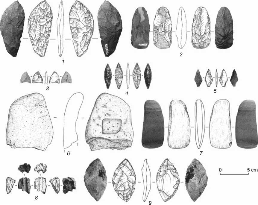
Fig. 4. Stone tools.
1–4 – Kitovyi-2, dwelling 5 and inter-dwelling area; 5–9 – Kitovyi-4, dwelling 1 and inter-dwelling area.
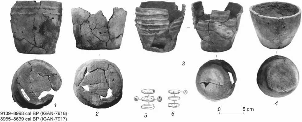
Fig. 5. Incipient Neolithic ceramics from Kitovyi-2 ( 1 , 2 , 5 , 6 ) and -4 ( 3 , 4 ).
ceramics of the Kurile Islands, Hokkaido, and Sakhalin. The closest parallels are the linear-relief pottery of the Ryukisenmon type in the northern part of Honshu Island. Thus, the above features suggest attribution of the ceramic complex from Iturup Island to the Incipient Neolithic, i.e. to the period before the appearance of the cultural phenomenon of Jomon pottery with cord imprints on the Kurile Islands.
Major results and interpretations
In the course of the excavations of the archaeological sites Kitovyi-2 and -4 on Iturup Island, several types of Neolithic objects were discovered, which were first recorded on the Kurile Islands as part of excavations over a large area. Two types of dwellings—terranean (without deepening of the wooden frame) and semisubterranean— were noted. The latter type is well-known from the Early and Middle Neolithic records of the islands of Sakhalin (Vasilevski, 2008: 191–192; Grishchenko, 2011: 80–81, 165–167; 2018: 22–24, 100) and Hokkaido (Obihiro…, 1988: 28, 31–32; 2006: 247–259). Terranean dwellings have not been previously studied on Sakhalin and the Kuriles.
Three original objects are platforms with long mounds and basalt plates laid out along the margins. The only acceptable interpretation of these structures is a ritual imitation of a terranean house with a burial bed in the center, where a double fence protects the “house of the deceased” and prevents the soul of the deceased from wandering in the world of the living, which corresponds to the more recent ideas of the Ainu about the souls of the dead as independent beings capable of coming back and harming people (Spevakovsky, 1988: 145–147).
We consider the mound to be a grave in which the remains of the cremated individuals were buried. The cremation ritual is indicated by the identified spots of calcined soil at the base of each object. Apparently, after burning, basalt plates brought from the coast were installed along the margins, and the space between them was filled with soil from a nearby pit. A fence was created around the lining; it is traced by a system of pits from poles around ritual mounds, similar to that of the terranean dwelling at Kitovyi-4, but without a gap marking the entrance/exit. Noteworthy is the conical profile of the pits, suggesting that the poles were not dug in, but that their ends were pointed and they were beaten into the ground. This indicates the symbolic nature of the structure surrounding the object. Since there are distances between the pits, we believe the poles were connected with wattle fence. The ceramic cylindrical beads found in mound 2 at Kitovyi-2 confirm indirectly the non-utilitarian nature of the structures.
Let us turn to the most general ethnographic parallels. The considered ritual mounds (let us call them long barrows) resemble stylistically the burials in boats described by L.Y. Sternberg, which are common among various peoples of the world. It was believed that such a burial allowed the deceased to return to the land of the ancestors in the same way that they once moved to a new place (Sternberg, 1936: 339). This parallel looks especially appropriate if we take into account the location of the described ritual complexes on the island, which clearly implies that the first generation of new
Kurilians crossed the sea on their way from their place of origin. The absence of earlier cultural layers suggests the pioneering nature of the settlement on Iturup by the bearers of the culture of linear-relief pottery and long barrows. And this supports the hypothesis of the boatburial tradition.
Apparently, there is an interrelation between the burials and specific dwellings at both settlements under study. The cemetery was built right next to the houses where the deceased lived. This can be interpreted both as the attachment of the living to their ancestors, and as a fear that animals or other people could harm the deceased relatives. In any interpretation, this fact speaks of the existence of the cult of ancestors, stable familyhousehold and religious-mystical traditions and rules of conduct, taboos and moral values. This indicates fairly developed public relations and regulated social behavior, as well as the rich spiritual world of Iturup dwellers. The very existence of settlements on the island of the Greater Kurile Chain, isolated from the mainland, suggests a sufficiently high level of development of storm navigation in the Sea of Okhotsk and the coastal economy, thanks to which the people of this culture could live off marine fisheries. These assumptions, as well as the described complex of dwellings, lithic industry, and pottery, attest to interpretation of the settlements of Kitovyi-2 and -4 as the Neolithic sites. The excavations of 2019–2020 revealed several functional zones in the studied area. The first is semisubterranean dwellings of year-round habitation; the second is summer dwellings or terranean warehouses; the third is a zone of economic activity in the space between dwellings; the fourth is a zone of ritual actions—fenced areas of ancestor worship.
Chronology
In total, nine radiocarbon dates have been derived for the settlements of Kitovyi-2 and -4* (see Table ): two dates were obtained from the samples of charred remains on the inside and outside of the walls of a ceramic vessel with a linear-relief ornament (see Fig. 5, 1 ); the others from the charcoal pieces in the hearths of dwellings and one ritual object (see Fig. 2, 3 ). Thus, at the present stage of the study, their age has been established in
Data of radiocarbon analysis
|
Lab code |
Sample description |
Date, yrs BP |
|
|
Noncalibrated 1σ (68 %) |
Calibrated 2σ (95.4 %) |
||
|
Kitovyi-2 |
|||
|
IGAN - 8034 |
Charcoal from hearth in dwelling 5 |
9 800 ± 130 |
11,647–10,758 |
|
IGAN - 7916 |
Charred remains from ceramic vessel, scrape from the outside |
8140 ± 35 |
9139–8998 |
|
IGAN - 7917 |
Charred remains from ceramic vessel, scrape from the inside |
7940 ± 40 |
8985–8639 |
|
Kitovyi-4 |
|||
|
IGAN - 8774 |
Charcoal from the filling of terranean dwelling 3 |
10,775 ± 30 |
12,757–12,720 |
|
IGAN - 8775 |
Charcoal from the floor of terranean dwelling 3 |
11,115 ± 30 |
12,950–12,926 |
|
IGAN - 8773 |
Charcoal from the hearth depression of dwelling 1 |
7375 ± 30 |
8142–8035 |
|
SOAN-9988 |
ʺ |
7990 ± 120 |
9264–8543 |
|
SOAN-9989 |
Charcoal from the hearth depression of dwelling 2 |
7005 ± 175 |
8182–7515 |
|
IGAN - 8776 |
Charcoal from the filling of the pit at ritual object 1 |
7570 ± 30 |
8415–8343 |
the fairly wide range of 13,000–8000 years BP; which undoubtedly requires clarification, but indicates the extreme chronological boundaries of the identified period of the Stone Age of the Kurile Islands—namely, the Incipient Neolithic.
Stages of the Neolithic on the Kurile Islands
Summing up the data available for the Neolithic of the Kuriles, we propose the following periodization.
-
1. Incipient Neolithic (13.0–8.5 cal ka BP). The stage is illustrated by complexes with linear-relief pottery and is associated with the culture of long barrows. The lithic industry of this stage is characterized by the predominant bifacial technologies in the manufacture of retouched tools from flakes and entire singularities with advanced stone polishing, based on development of local basalt deposits. The occurrence of a few obsidian items suggests early exchange ties with the population of Hokkaido.
-
2. Early Neolithic (9.0–7.5 cal ka BP). This stage is identified hypothetically, because excavations of complexes of this period on the Kuriles have not yet been carried out. However, relying on the data of adjacent regions—primarily Sakhalin, Hokkaido, and Kamchatka—we assume that the early stage was associated with the blade arrowheads culture. The lithic industry is dominated by blade technology and the use of obsidian from Hokkaido and jasperoids and basalts from the island region. Pottery from this period is diverse and comprises several types—Akatsuki, Urahoro, and
-
3. Middle Neolithic (7.5–6.0 cal ka BP). Archaeological complexes of the Yankito-1 and -2 type on Iturup Island, with pottery bearing traces of wall-smoothing with a solid comb, and lithic industry based on the bifacial technique of tool-manufacturing from flakes and entire singularities, are associated with the Early Jomon in Japanese historiography and were considered by some authors as the Early Neolithic complexes of the Kurile Islands (Kuzmin et al., 2012). Given the recent research results, in terms of the generally accepted periodization, this stage should be identified as the Middle Neolithic.
others. Separate traces of this stage were recognized during exploratory studies on the islands of Iturup (Rybaki-3), Shikotan (Malokurilskoye-1), and Kunashir (Lagunnoye-15).
Further studies of the archaeological sites of the Kurile Islands by excavating large areas are necessary to clarify the periodization of the Stone Age of the archipelago.
Conclusions
During excavations of the lower horizons of Kitovyi-2 and -4 in 2019–2020, an original archaeological complex was discovered that has no parallels on the Kurile Islands, as well as on Sakhalin and Hokkaido, to this day. It seems that in ancient times both sites belonged to a single large settlement on the coast and in the coastal zone of Kitovyi Bay. The most noteworthy elements of the complex are ritual structures in the form of mounds encircled by fencing of plates; these are presumably places for the burial of the cremated remains of the deceased, and for the worship of ancestors. On the basis of this distinct and important feature, we propose to associate the studied Neolithic complexes with the Early Neolithic culture of long barrows.
The morphological similarity of the Iturup pottery with the linear-relief pottery of the Early Jomon culture dating back to 12–14 ka BP from the islands of Honshu and Kyushu (Special exhibition…, 2009: 35–38) is noteworthy. The northernmost point of occurrence of this pottery in Japan is the Hacchazawa-1 site in the far north of Honshu Island (Hacchazawa…, 1988: 36). Given the geographical gap between the north of Honshu and the Iturup, we assume a one-time migration of a well-organized group of fishermen on boats in the meridional direction from south to north.
References The incipient Neolithic of the Kurile islands: the culture of long barrows
- Atlas Kurilskikh ostrovov. 2009 Moscow: Dizain. Informatsita. Kartografiya; Vladivostok: Feoriya.
- Chubarova R.V. 1960 Neoliticheskiye stoyanki na o. Iturup. Sovetskaya arkheologiya, No. 2: 128-138.
- Fitzhugh B., Moore S., Lockwood C., Boone C. 2004 Archaeological paleobiogeography in the Russian Far East: the Kuril Islands and Sakhalin in comparative perspective. Asian Perspectives, vol. 43 (1): 92-122.
- Fitzhugh B., Shubin V.O., Tezuka K., Ishizuka Y., Mandryk C.A.S. 2002 Archaeology in the Kuril Islands: Advances in the study of human paleobiogeography and Northwest Pacifi c prehistory. Arctic Anthropology, vol. 39 (1/2): 69-94.
- Golubev V.A. 1964 Po sledam drevnikh kostrov. Dalniy Vostok, No. 2: 149-151.
- Golubev V.A. 1972 Arkheologiya Kurilskikh ostrovov: Cand. Sc. (History) Dissertation. Novosibirsk. Grishchenko V.A. 2011 Ranniy neolit ostrova Sakhalin. Yuzhno-Sakhalinsk: Sakh. Gos. Univ.
- Grishchenko V.A. 2018 Levoruchyinskiy kompleks ranney fazy srednego neolita ostrova Sakhalin: Raskopki poseleniya Leviy ruchey 2, punkt 2 v 2011 godu, raskop No. 2. Yuzhno-Sakhalinsk: Sakh. Gos. Univ. (Trudy Sakhalinskoy laboratorii arkheologii i etnografi i; iss. 1).
- Hacchazawa (1) iseki [Hacchazawa-1 Site]. 1988 Aomori: Aomori-ken Kyoiku Iinkai. (In Japanese).
- Knorozov Y.V., Spevakovsky A.B., Taksami C.M. 1984 Piktografi cheskiye nadpisi aynov. In Poleviye issledovaniya Insituta etnografi i: 1980-1981. Moscow: Nauka, pp. 226-233.
- Kono T. 1905 Chashi or fortresses of the Ainu. Transactions of the Sapporo Natural History Society, vol. 1: 73-90.
- Kuzmin Y.V., Yanshina O.V., Fitzpatrick S.M., Shubina O.A. 2012 The Neolithic of the Kurile Islands (Russian Far East): Current state and future prospects. Journal of Island and Coastal Archaeology, vol. 7 (2): 234-254.
- Milne J. 1882 Notes on the Koro-pok-guru or Pit-dwellers of Yezo and the Kuril Islands. Transactions of the Asiatic Society of Japan, vol. X (2): 187-198.
- Obihiro Archaeological Records No. 7: Obihiro. 1988 Akatsuki site 3. Obihiro: Board of Education. (In Japanese, with English titles).
- Obihiro Archaeological Records No. 27: Obihiro. 2006 Taisho sites 2. Obihiro: Board of Education. (In Japanese, with English titles).
- Phillips S.C., Speakman R.J. 2009 Initial source evaluation of archaeological obsidian from the Kuril Islands of the Russian Far East using portable XRF. Archaeological Sciences, vol. 36: 1256-1263.
- Prokofi ev M.M. 1986 Arkheologicheskiye pamyatniki o. Iturup (po rezultatam razvedok 1983, 1985 gg.). In XXVII syezd KPSS i zadachi muzeynogo stroitelstva v Sakhalinskoy oblasti. Yuzhno-Sakhalinsk: Sakh. obl. krayeved. muzey, pp. 18-20.
- Prokofi ev M.M. 1995 Nakhodki keramicheskikh izdeliy kultury satsumon s kalendarnoy simvolikoy na o. Iturup. Krayevedcheskiy byulleten: Problemy istorii Sakhalina, Kuril i sopredelnykh territoriy, No. 3: 135-139.
- Prokofi ev M.M. 2001 Noviye materialy po arkheologii o. Iturup (iz polevogo dnevnika 1986 goda). Krayevedcheskiy byulleten: Problemy istorii Sakhalina, Kuril i sopredelnykh territoriy, No. 3: 21-35.
- Prokofi ev M.M. 2003 Keramika rannego dzyomona s Yuzhnykh Kuril. Krayevedcheskiy byulleten: Problemy istorii Sakhalina, No. 1: 89-94.
- Samarin I.A., Shubina O.A. 2013 Pamyatniki istorii i kultury Yuzhno-Kurilskogo rayona. Yuzhno-Sakhalinsk: Sakh. obl. krayeved. muzey.
- Schnell I. 1932 Prehistoric fi nds from the Island world of the Far East, now preserved in the Museum of the Far Eastern Antiquties, Stockholm. Bulletin of Museum of Far Eastern Antiquities, Stockholm, No. 4: 15-104.
- Shubin V.O. 1994 Aleut in the Kuril Islands. In Anthropology of the North Pacific Rim, W.W. Fitzhugh, V. Chaussonet (eds.). Washington: Smithsonian Institution Press, pp. 337-345.
- Shubina O.A. 2012 Obzor kollektsiy Rannego i Srednego Dzyomona Kurilskikh ostrovov iz fondov Sakhalinskogo oblastnogo krayevedcheskogo muzeya. Vestnik Sakhalinskogo muzeya, No. 19: 125-172.
- Special Exhibition: Beginning of the Jomon Culture: What Took Place in 15,000 Years Ago? 2009 Sakura: National Museum of Japanese History. (In Japanese, with English titles).
- Spevakovsky A.B. 1988 Dukhi, oborotni, demony i bozhestva aynov (religiozniye vozzreniya v traditsionnom aynskom obshchestve). Moscow: Nauka.
- Sternberg L.Y. 1936 Pervobytnaya religiya v svete etnografii: Issledovaniya, statyi, lektsii. Leningrad: Izd. Inst. narodov Severa TsIK SSSR.
- Steshenko T.V., Gladyshev S.A. 1977 Drevniye pamyatniki Kurilskikh ostrovov. In Issledovaniya po arkheologii Sakhalinskoy oblasti. Vladivostok: Dalnevost. nauch. tsentr AN SSSR, pp. 21-37.
- Torii R. 1919 Les Ainou des Iles Kouriles. Journal of the College of Science. Imperial University of Tokyo, vol. XLII (1): 1-337.
- Vasilevski A.A. 2008 Kamenniy vek ostrova Sakhalin. Yuzhno-Sakhalinsk: Izd. Sakh. Gos. Univ.
- Vasilevski A.A., Grishchenko V.A., Orlova L.A. 2010 Periods, boundaries, and contact zones in the Far Eastern insular world of the Neolithic (based on the radiocarbon chronology of sites on the Sakhalin and Kuril Islands). Archaeology, Ethnology and Anthropology of Eurasia, No. 1: 10-25.
- Vasilevski A.A., Potapova N.V. 2017 Ocherki istorii Kurilskikh ostrovov. Vol. 1: Istoriya Kurilskogo arkhipelaga s drevneishikh vremen do Sankt-Peterburgskogo dogovora 1875 goda. Yuzhno-Sakhalinsk: IAET SO RAN, Sakh. Gos. Univ.
- Yanshina O.V., Andreeva M.A., Pantyukhina I.E. 2008 O rannem neolite Kurilskikh ostrovov: Stoyanka Yankito-1. Rossiya i ATR, No. 1: 75-87.
- Yanshina O., Kuzmin Y. 2010 The earliest evidence of human settlement in the Kurile Islands (Russian Far East): The Yankito site cluster, Iturup Island. Journal of Island and Coastal Archaeology, vol. 5: 179-184.
- Zaitseva G.I., Knorozov Y.V., Spevakovsky A.B., Prokofiev M.M. 1989 Absolyutnaya khronologiya drevnikh seleniy Kurilskikh ostrovov. In Issledovaniya po arkheologii Sakhalina i Kurilskikh ostrovov: Tezisy vystupleniy na II arkheologicheskikh chteniyakh, posvyashchennykh pamyati R.V. Kozyrevoy. Yuzhno-Sakhalinsk: pp. 24-28.
