The islands of the White Sea, from the Mesolithic to the Middle Ages (the ancient development of the White Sea islands on archaeological data)
")
Author: Martinov А.Y.
Journal: Arctic and North @arctic-and-north
Section: History
Article in issue: 5, 2012.
Free access
The article is devoted to the history of development of the White Sea Islands (Solovki, Kuzova, Zhizhgin, Mudyug) in the Stone Age − Iron (VI millennium BC. E. − I millennium AD. E.). On the basis of archaeological sources and experimental data it contains answers to questions about the nature of the ancient island of settlements, the culture of their inhabitants, cultural ties with continental cultures, ancient sea routes, origin and destination of stone labyrinths of the White Sea.
White Sea, Solovki Islands, an ancient settlement, excavations, artifacts, pottery, stone tools, labyrinth, an experiment, a boat
Short address: https://sciup.org/148320473
IDR: 148320473 | UDC: 904(470.116) (045)
Text of the scientific article The islands of the White Sea, from the Mesolithic to the Middle Ages (the ancient development of the White Sea islands on archaeological data)
A short geological - geographical characteristic
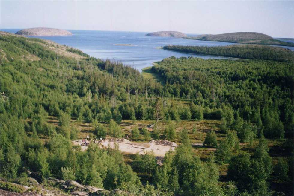
The White Sea - one of the few, and the smallest sea in the Arctic Ocean. Its area - 90000 square meters. km length of coastline - 2,000 kilometers. From the North Sea is limited to south -Terek and Kandalaksha - shores of the Kola Peninsula, the west is washed by the Karelian and Pomeranian coast (Karelia), to the south - Onega, Summer and Winter shore (Arkhangelsk region). White Sea Islands mainly concentrated in the western half of the pond. The largest of these are great Solovki, Anzersky, Myagostrov, Kondostrov and Russian body. Two of them are united around the island's largest archipelagos of the White Sea: Solovki and body.
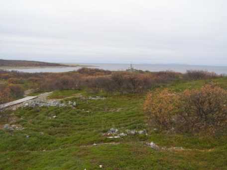
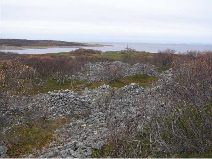
The Solovki archipelago consists of 6 large and 110 small islands in the western part of the White Sea at the entrance to Onega Bay. The shortest distance from the main island of the archipelago - Solovki - to the west coast, "as the crow flies" is 35 miles from the island Anzerskogo to the south-east coast - the arrows of the Onega Peninsula - 25 km. In respect of archaeological interest are the greatest major islands: Big Solovki (225.28 sq. km.), Anzersky (48.51 sq. km.), Big Muksalma (19.91 sq. km.), Greater and Lesser Zayatsky (respectively 1.38 and 1.24 sq. km.). Total area of the archipelago naturalist determined in 295.23 sq. m. km (Schwartzman, Bolotov etc, 2007, p. 184).
The archipelago Body (translated from Sami - "Spruce Island") is located 20 km west of the Solovki Archipelago in the 12-15 km east of the Karelian White Sea coast. Separated from the three-kilometer strait Kem Islands, the archipelago consists of twenty islands, which are rocky dome, composed of crystalline rocks and protruding from the water to a height of 123 meters. The islands are visible signs of tectonic activity, rock is visible from afar interrupted gully with taiga vegetation. At the base of the cliffs, as a rule, there are convenient for the residence of Bani-important area of human groups 8-10 and 16-20-meter height above sea level, adjacent to sources of fresh water - isolated, but rather large springs, and many rocky basins and depressions that fill with rainwater during the summer. The area of the largest islands of Russian and German body is approximately 7 and 1.5 square meters. Miles. Other islands in the archipelago are
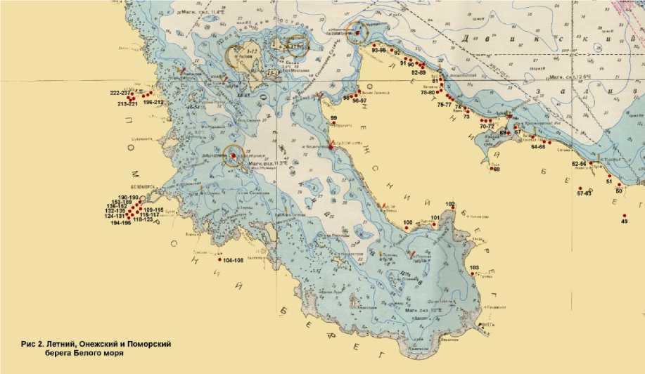
much smaller in size, their height above sea level ranges from 15 to 65 m (Pic. 1).
The beginning of the geological history of the archipelagos, as well as the entire White Sea, goes back to antiquity (late Archean times), when the thickness of the White Sea was formed gneisses (Demidov, 2002, p. 10). Recent geological history of the White Sea islands is very complicated. Simply put, they are formed by Quaternary glacial and fluvioglacial sediments of the last glaciations, overlying the mounting platform of an ancient, formed by crystalline rocks. As the melting of the ice sheet and reduce its area occurred compensatory uplift of islands that bore an intermittent nature. Then there was the formation of "ladders" of marine terraces above the cur- rent level of the White Sea to a height of from 5-10 to 20-23 m (Kheladze, 1926, Kolosov, Novikov, 1996, p. 134-135; Demidov, 2002, p. 10).
The research of primitive monuments of the White Sea Islands
Professional archaeological study of prehistoric past the islands of the White Sea is the second half of 1920. Over the years, archaeologists have worked on Solovki Vinogradov (1926-1931), A.A. Kuratov (1964-1981) and Alexander Martynov (1984 to Present. Time).
-
Н. N. Vinogradov was first surveyed about 1,000 stone additions (mazes, mounds, "symbolic" computations), published the first and only in the XX century book on archeology Solovki (Vinogradov, 1927), as well as a number of scientific and popular articles. They formulated the basic problems associated with the stone maze, and proposed a hypothesis about the dating, cul-
- tural background and purpose of "Babylon."
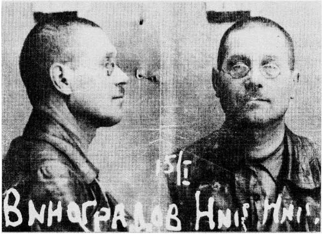
Pic. 2. N.N. Vinogradov
A.A. Kuratov and he founded the Arkhangelsk archaeological expedition carried out a second survey is open stone calculations, stationary investigated three stone embankment, discovered and partially excavated the first two parking Archipelago (Bronze Age), and thus were the first real archaeological sources. Researcher published several articles and a monograph (Kuratov, 2008), devoted to problems of prehistoric archeology Solovki archipelago.
-
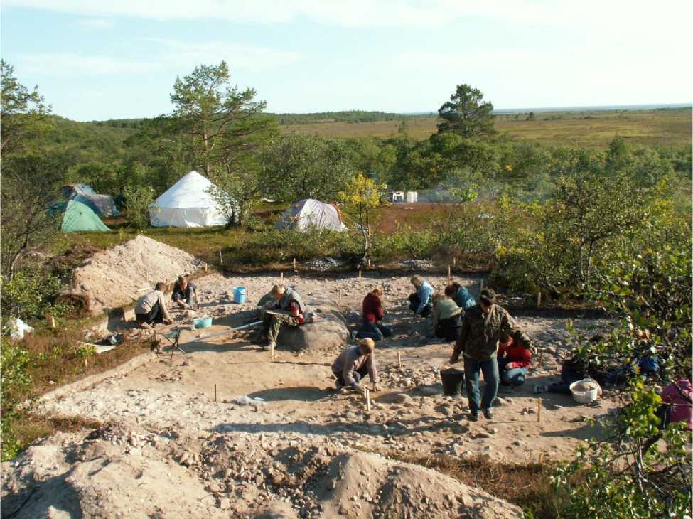
A. Martynov and members of the archaeological expedition of the Solovki museum opened 58 primitive sites, workshops and locations of waste stone industry VI millennium BC. Oe. - I millennium AD. Oe. They excavated 25 sites and 20 stone embankments received more than 30,000 artifacts discovered and studied the monuments' before monasteries period "Middle Ages. Successfully implemented the project "Solovki - the continent: the ancient sea routes. Reconstruction of routes and modes of transportation on the White Sea in the antiquity and middle Ages. "Published three books (Martynov, 2002, 2006, 2010) and over 40 articles on the history of development and culture of the islands of the White Sea in the Mesolithic - the Middle Ages.
The primitive Bodies parking lot of the archipelago have been discovered and investigated Kuratov AA (1989) and A. Ya Martynov (1990, 2002, 2004), as well as the Karelian archaeologists
NV Lobanova, and JS Manyuhinym (2002), A. Zhulnikovym M. (2007) and M. Shakhnovich (2007). Campsites on Zhizhgin partially excavated by the author of the article (1995, 1998), about the parking. Mudyug to investigate the A. Ya Martynov (1984, 1995) and A.E. Belichenko (1995, 1996)
Ancient parking of the White Sea Islands
The history of the ancient development of the White Sea islands away in the late Mesolithic period, from mid-sixth to the middle of the fifth millennium BC. It is dated to this time the remains of ancient camps and workshops are open to the archaeological expedition Solovki Solovki.
And it was at this time are the most recent parking Mesolithic era and the oldest (earliest) the settlement of North Karelia with ceramics (pottery), whose appearance is considered to be the main feature of the next period of history - "New Stone Age," Stone Age. However, full confidence in the fact that archaeologists do not find a more ancient island park with us, of course, not.
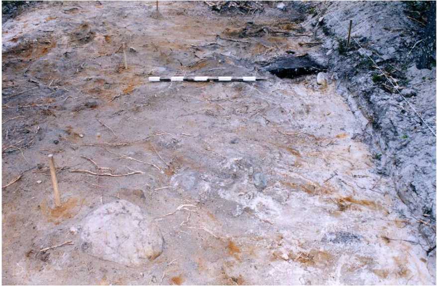
The oldest island settlements - a seasonal (summer), parking lots, which are located some distance from the modern coast and the Solovki Islands Anzerskogo, as well. Muksalma, high (18-
20 m above sea level) of sand and sand-stone terraces, near lakes or marshes (Pic. 3).
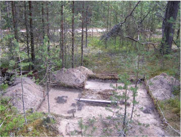
The size of areas that are occupied by the discoverers of the islands are small (from 400 to 2500 sq. m.). The thickness of the formed with their participation of the cultural layer (from 3 to 20 cm) is such that you can with some reason to believe: they lived in a small (10-15 people) group of people who are likely to have visited the place many times, they have chosen to stay. This is confirmed by radiocarbon dates of samples of coal from the hearths of several parking lots and parking of multi-ceramic workshop Muksalma-6.).
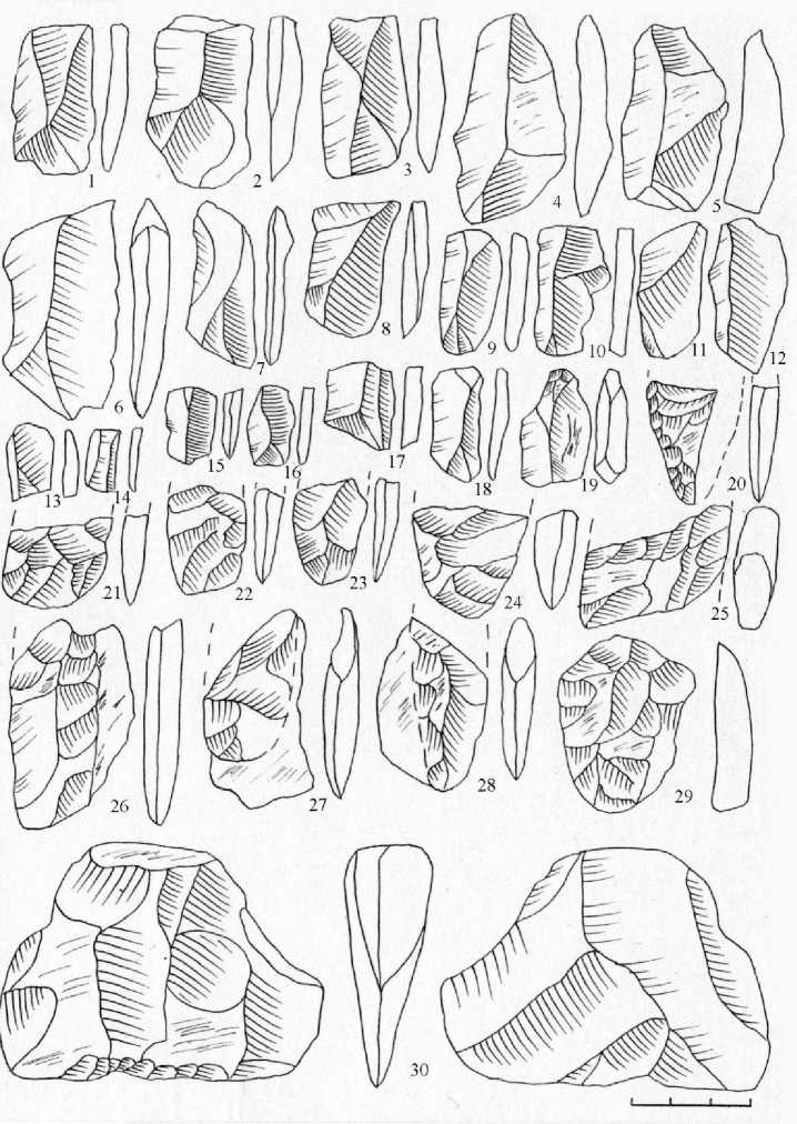
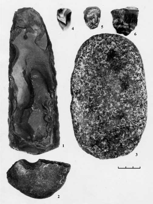
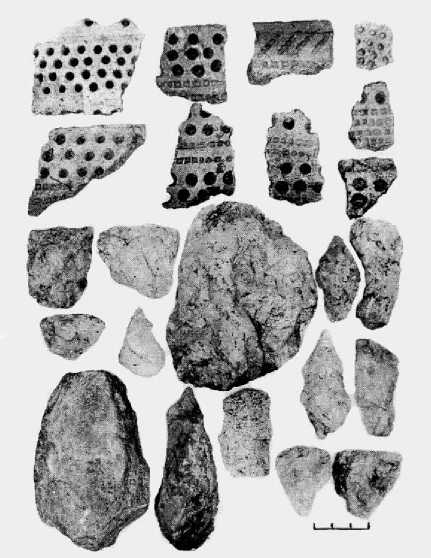
During the excavation of these seasonal settlements was gathered an impressive collection of stone implements, among which there were also fragments of hunting weapons (composite spear, dart tips and arrowheads), and household tools (axes, scrapers, fragments of knives, awls, chisels, scrapers ) and commercial products (fishing weights) (Pic. 4).
No less interesting were observations of how the discoveries were located on the grounds of parking. The majority of them were revealed in the form of clusters of different size, archaeologists have received the title "master of the place." The most common (eg, parking Solovetskaia-4 and Small Kumin) is quite large in size, but individual clusters, sometimes (in German Body-3) a group of smaller clusters, arranged in a circle with a boulder, "anvil" near one of them. As a rule, meets an archaeologist in such places whatever, except for whole articles: chipped stones, cores, large flakes, prepared for further processing, chips, flakes (small and tiny flakes), and harvesting of various products and parts procurement, of broken in the manufacturing process. "Place Wizard" - it's really kind of mini workshop in the open, where he worked who have sufficient ability, physical strength and patience to transform amorphous silica chips with a nodule in a different shape, sometimes beautiful, axes, scrapers, knives. The experiments were specialists from the Institute of Archaeology leave no doubt that this was done not very easy.
Another category of finds - individual artifacts found on the entire area of the settlements in different horizons of the cultural layer at different distances from each other. Their presence can be explained by several reasons. Some of them were discarded masters were fabricated tools (flakes, chips), other (gun, suitable for use) dropped by owners of products, and others (fragments of "work" guns) discarded as useless. There have been specifically brought to the parking lot "from the" items: coasters, "anvil", sinkers, anchor stones, large quartz nodules. Location of inventory accumulation and individual findings led us to the conclusion that at some sites of their inhabitants is quite clearly separated two "zones": the production, which was attached to the edges of the terraces and are often located on the moraine rocks, and "living", separated from the slopes of 10 - 15 meters and is located on the sand. This separation is yatno and explained: on the stones easier to split the quartz nodules, it is more convenient to move around in the sand, stand, sit, make fire, roost...
Binding sites are part of the ancient campfire, or foci, near which, presumably, the primitive "islanders" spent a lot of time. They vary in size (diameter, thickness of coal fly ash-layer texture) and shape (oval, round, amorphous), suggesting a different life in a particular settlement: very short on the shore of the lake is very small cumin and long-stationary-Solovetskaia 15. Laboratory analysis of coal from the hearth parking Solovetskaia-4 (Fig. 5) allowed to set a date for one of the oldest to date archeological White Sea islands - 6460 ± 70 BP (years ago).
Even more impressive is the dating of charcoal from the cultural layer is open in 2011 and has not yet excavated parking Solovetskaia-21, established the Laboratory of Isotope RSPU. AI Herzen - 7600 ± 70 BP.
Judging by analogy to the stone inventory (axes, harvesting tips from the lateral plate, scrapers, chippers, cores) in the raw material (quartz) and in the earliest samples of pottery ornamented with a patching material for parking Pribelomorya, the inhabitants of the oldest island settlements came Solovki from the west coast of the White Sea, or rather from the lower reaches of the rivers Kemi and Vig.
The Solovetskii Islands in the period of the Neolithic
The development of White Sea islands was continued in IV-III millennium BC. Oe., but this time the islands were already different. Strictly speaking, they changed their shape and dimen- sions of all ages, but judging from the topography of the sites Kolguevskaya-2, 3 and 4, cemeteries, Muksalma-2, 5 and 9, the most notable changes have taken place just in the developed and the Late Neolithic. It can even determine the location of ancient monuments. If early Neolithic parking Solovki, and body separated from the modern shoreline at a distance of not less than 500 meters and situated at a height of not less than 18 m above sea level, the Late Neolithic are much closer to the coast (50-150 m), and their height does not exceed 14 - 15 meters.
However, in the second half of the IV millennium BC. in the history of navigation and exploration of the northern White Sea islands have been significant changes . They concluded that in addition to the west (with the Karelian coast) came south-east "sea" way to Solovki Pribelomorya from the South, with the Onega Peninsula
(today's Arkhangelsk region).
The island populations of these people are very different from all previous and subsequent.
The ancient monk The summer beach dune hollow-mastered pits Kolguevskogo Cape Anzerskom on the island. Cavities are holes in the sandy terrace depth of four meters and an area of 100 to 1,500 square meters with fairly high walls. In one of them, they settled down, judging by the impressive cultural layer, on a very long time (Pic 7).
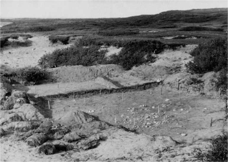
A dozen other basins were used as places where they split the master quartz nodules, and of the formed in the primary cleavage flakes produced blanks of different tools: scrapers, proko-lok, knives, arrowheads and darts.
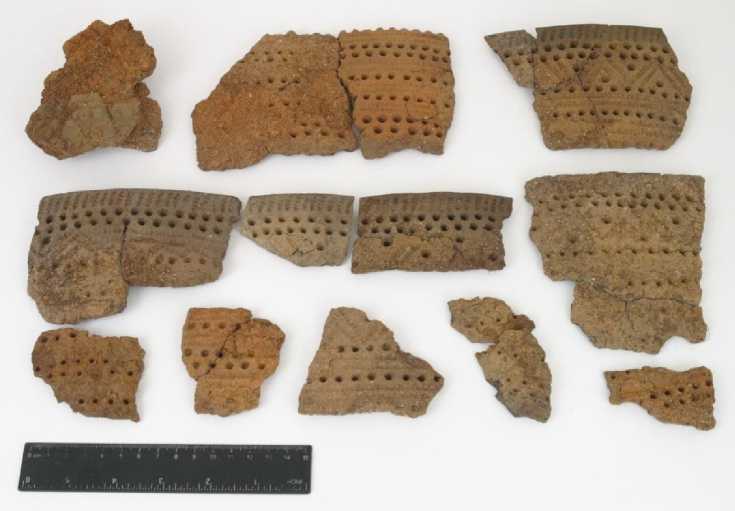
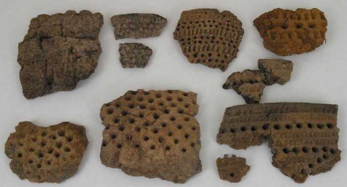
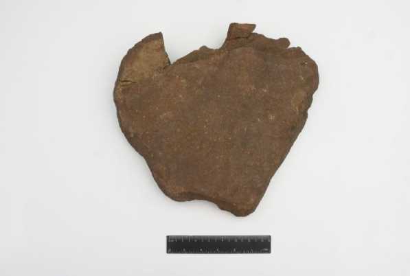
The selection of dune depressions and stone-working for a living "workshops" was not accidental, as no accident, and the fact that the only settlement on the damn-zhe Onega peninsula, where archaeologists in the first half of the XX century have been found similar to 'kolguevskoy "pottery and stone tools, was parking in a dune hollow on the banks of the river Galdarei. In all likelihood, that the inhabitants of the settlement Galdareya-1 were the first "onezhan" who, from that time until the beginning of a new era, from time to time visited the Solovki Archipelago. Monk parking Kolguevskaya-2 not only owned quartz stock, although he was more than 90% of all products, but also tools, made of flint, slate gray and red sandstone. A set of commercial inventory of these people was much wider, and made themselves the product more closely than their predecessors. Among them are a variety of weights (oval with "interception" and round with holes), scrapers, grinding slabs, hunting ax, and the reader is familiar knives, scrapers, awls, drills, fragments of arrowheads and spears, pieces of chopping tools. Dishes, which used to Kol-guevskoy-2, was a large and small vessels poluyaytsevidnoy form, fashioned from yellow, red and gray clay and decorated with ornaments of conical pits alternating with impressing the so-called "comb".
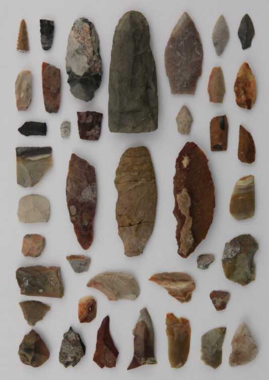
Judging by the fishing gear, discovered in the parking lot, its inhabitants were hunting migratory birds, marine and island animals, catch fish, not only archaic hunting techniques (with a bow, arrows and darts), but also by fishing nets or other projectiles, requiring the use of weights. They brought with them implements of flint (Pic. 8), which is not in Solovki, and perhaps found in the parking lot of the pottery.
Flint brought exclusively in the form of finished products. In this clearly indicates the complete absence of the monument in the cultural layer of flakes, chips and flakes - waste flint industry, always accompanying the stone tools there, where the initial cleavage and production of flint tools. As for the ceramics, we can not exclude that some vessels were made on Solovki, in any case, the clay of similar colors we found in different parts of the archipelago. Judging by the traces of smoothing on the inside of blood vessels, they produced the so-called tape method. Well mixed with sea sand and plant fibers clay rolled in a rather narrow bands, which are superimposed on the spiral of a "bottom up" and then his hands and tufts of grass, wipe out the inner and outer vessel wall. Causing the ornament on the entire outer
surface of the "pot", an ancient wizard burned him at the stake (Pic.9).
Quartz equipment manufactured in two stages. First, split the old masters of quartz and schist boulders and knocked them to the so-called nodular crust to check the quality of raw materials, and then cleaved flakes - the basis for future tools. Is carried out in the "shops" - dune depressions, located near the settlement. Flakes and chips which were good for secondary treatment, was transferred to the parking lot, and there is first turned their guns in the blanks, and then "adjusted" (if able) to the products ready for use.
Of particular interest is the oldest found in the White Sea populations anchor stone. It is not a stone anchor, because there are no openings for tench and wooden or bone anchor the "horns", but the shape of
the object, the traces of processing and, in particular, artificial grooves on opposite faces can confidently assert that it used in this quality.
To IV-III millennium BC include a number of parking spaces, located on the open sandy terraces Anzerskogo (Kolguevskie 3 and 4, cemeteries), B. Solovki (Solovetsky-3, 5, 15), B. Muksalmskogo (Muksalma-2, 3, 5, 9) of the islands. On-site parking repeatedly visited Workshop Muksalma-6 in the 2006 excavation (fig. 10) also found several sculptured vessels and stone tools dating from the late Neolithic.
The materials of these settlements are very much complementary to our understanding of the insular culture of the time. Their inhabitants were molding thin-walled and thick-walled ves- sels of specific shapes of different sizes. Their diameter varies from 20 to 40 cm, height - 30 to 45 cm outer surface of stucco "pots" primitive masters covered the so-called comb-patching ornamentation, which prints stamps comb prevailed over the number of pits. Together they accounted for very diverse and original combinations. They are produced and very small cup diameter of 12 cm and a height - 6-8 cm, decorating them with rows of tiny pits and shallow impressions "comb". As for the stone tools, in addition to normal household and hunting implements of the inhabitants of these settlements quartz schist used sinkers "interception", grinding slabs, chippers, as well as stand-massive "anvil" of hard sandstone, which rested in a quartz nodules in shear with these flakes. Parked Muksalma-6 was detected strongly touch stone with mysterious notches on the side face of the product and the two triangular indentations on the sides, for which the tool is tied to his belt with the strap.
Solovki in the period of an early metal
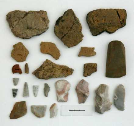
In the culture of mainland hunters and fishermen who visited the White Sea islands in the early metal in II-I millennia BC has several important tures. Noticeable changes in the material culture of the island population can be traced in the second half of the III millennium BC. Eneolithic sites in the materials and they are related primarily to the re- placement of quartz raw materials to better and more flexible to handle the flint. If more ancient sites of quartz products and waste industry are 95-97% of all items made of stone, in the Chalcolithic ("copper-stone age") imported flint 'gains' of up to 30%. The tools made of flint, quartz is much stronger, the form of tips, scrapers and knives becomes stable, they are beautiful and attractive. Flint delivered Solovki not only in the form of finished products, but also instruments of work pieces, and in the form of cores - shot up from all sides of flint nodules, from which you can still shear off flakes. This is evidenced by a fairly large amount of waste flint industry found in the cultural layer Eneolithic sites Solovetskaia Muksalma-13 and-8. Judging by the analogues in the mineral known deposits of Karelia and the basin. Northern Dvina, flint sites of this time was taken to the island with Lake Onega, and from Orlets. At the Chalcolithic settlements are new items for the Solovki: the massive "cutting board" found broken into three parts, an elegant adze, made clear on the mainland, and most curious thing in the island archeology - amber button, similar to such ornaments in the Eneolithic sites of North Karelia. The appearance of her colleagues in the area associated with the existence of cultural ties between the primitive inhabitants of Karelia and the Baltic States. Dishes of this time are different from the previous form and ornamentation. The vessels found in the parking lot Solovetskaia-13, smaller in size, shape, they are close to spherical, and in the ornamentation of pits have almost entirely disappeared (Pic. 11).
Especially notable changes can be traced to the culture of island settlements of the Bronze "age". Stone tools at these sites in the 90-93% consists of imported (from the Northern Dvina), flint and slate and sandstone. Local minerals - quartz - in the cultural layer are almost no parking. A set of products different from the Neolithic even wider range and better treatment. Among the items found by archaeologists have at least five types of arrowheads, darts and spears, six varieties of pigs, three types of knives, a variety of shapes and sizes awls, scrapers, scraper, axes (Pic 12).
In contrast to the Neolithic settlements Kolguevskoe-2 and Muksalma-6, and 9 residents parking an early metal Solovetskaia-13-1 Muksalma, Kaporskaya, Kolguevskaya-1, Body-2 German and Russian Body-1 produced spherical mediumsized vessels, which were decorated with "comb "or" grid "pattern. The pits were deposited on the surface of blood vessels is extremely rare, and they do not play a significant practical role.
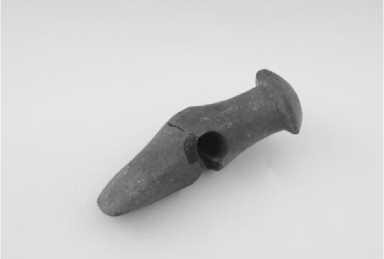
For all the dislike of archaeologists to the word "unique" several items of the time will have to enroll in this class. One of
them - polished ax, a similar "battle-ax with a perforated pistil ax," was once a distinguished archaeologists A.Y. Bryusov and M.P. Zimin (1966, p. 27-28) from a variety of other chopping tools. Solovetskaia finding such ax was seventeenth in the USSR and the most northerly, indicating a very distant relationship with the holders of the ancient tribes who lived on the Upper Volga. Features of the island ax (size, curved shape, the hole for the handle diameter 1.5 cm) are such that use it as a battle and even more so as the owners, respectively was impossible. Therefore, we could draw only one conclusion - this ax on Solovki was wearing a ritual function (Pic. 13).
In addition to this, the archaeologists have found a few flint figures, images of animals -seals, are also extremely rare finds on the islands of the White Sea.
The archeologist link the parking of the period of an early metal with the inhabitants of the southern coast of the White Sea.
The development of the ancient White Sea islands in ancient times ended in the early Iron Age, in the first half of I millennium AD. Campsites are located at this time of low marine terraces, and their stock (plain household items and rough flat-bottomed dishes) shows the decline of Stone "production" due to the gradual "occurrence" in the primitive culture of the North metals: copper, bronze and iron. Travel the continental Early Iron Age inhabitants, according to the small number of sites have been rare, and possibly associated with the burial of the dead fellow and visiting the so-called "sanctuaries" of the Solovki archipelago, far more well-known reading public, rather than prehistoric campsites and "workshops".
The main occupations of the ancient «islanders»
What were the occupations of the ancient inhabitants of the White Sea islands in the VI-I millennia BC? What has been their subject of the daily life?
Obtained in our expedition materials indicate that their constant concern was to manufacture stone tools, for which they found in the archipelago are several types of raw materials: quartz and quartzite of varying quality (gray, porous transparent to high), gray and red sandstone and shale. Quartz did the bulk of commercial and consumer equipment (arrowheads and spears, axes, knives, scrapers, scrapers, scraper, borers), sandstone and shale - anchor stones, sinkers and "anvil".
«A special "song" - the ancient "Workshops" are open to the expedition of Solovki and body. There are only three, but each is so individual that deserves a separate description and interpretation.
The first of them, our intelligence discovered in 2002 on the east coast of the island B. Muksalma. Notice it was due to the large quartz boulder that lay in the middle of a sloping terrace, which consisted of several stone ridges. One edge of the boulder had been shot up, and next to him beneath the turf, could be seen half a dozen flakes. In the pit, laid next to the boulder, an area of 1 sq. m. m, 10 centimeters of cultural layer were discovered more than 600 items. Among them are pieces of blank products (scrapers, tips), cores, chips, flakes, flakes. The site, which served the old master, is small - not more than 6 square meters and the choice of location for such a "mini workshop» due to two factors: the presence of the above mentioned boulder and the nature of the terrace on which you can now find a lot of quartz. It is clear also that at this point was carried out only primary cracking of quartz material and it’s processing prior to harvesting, which has turned into instruments of the nearby parking lots "Muksalma-2, 5 and 6.
The second workshop is an exact opposite: a long, narrow terrace of the northern coast of the island of Solovki we recorded up to a dozen different concentrations of quartz objects: ready-to-use tools, blanks, quartz waste industry. There were also investigated several oval-shaped depressions with a cultural layer inside them - most likely short-term summer dwellings of the ancient fishermen. These features (the presence of shells and remnants of dwellings), new object prehistoric archeology suggest that the workshop was both a seasonal fishing camp.
The third workshop was found on the side of a granite cliff Russian Body, about a quartz "veins" and was a rather large waste collection industry with some things, which were clearly not well made, blanks arrowheads.
Thus, over several millennia the ancient inhabitants of the White Sea islands of stone tools were made in different places: during short stops in the workshop "open air", linked to the outputs of raw materials - quartz, quartzite and slate, in parking lots - workshops and temporary settlements.
However, even then mainland residents brought with them a stone implements, made of more durable and high quality minerals - flint, which is practically not on the White Sea islands. Judging from the extremely rare finds in the cultural layer of the oldest island sites only fragments of the broken items, but their inhabitants were imported ready to use household and hunting implements. This practice is likely related to the small number of flint, prevailed, as shown by archaeological excavations of Karelia, on the West Coast settlements early Neolithic the White Sea. The latter is a historical fact is explained by the absence of natural output of flint in North Karelia. According to research by A.M. Zhulnikova, Flint delivered Pribelomore with Lake Onega and the Onega River, and its number increased gradually. With increasing supplies of flint at sites of western and southern coasts of the White Sea and its growing number of car parks on the island until it is almost completely replaced the use of the main local mineral - quartz
The main daily activities of these people were, of course, getting food. Judging by the composition and size of the stone implements of hunting guns, the most ancient "natives" themselves and hunted sea mammals, and the island game. On the seal and bearded seal are hunted with composite shells, the remnants of which form the so-called "cross-liners" (fragments of knife-like blades), we were able to detect the early lots. Migrating birds can strike with bows and arrows, blanks which were found at sites Solovetskaia-4 and German Body-1. The cultural layer is not sites preserved for us, no tree, no bones, but rare occurrences of weights suggest that fisheries, including the Uses of some braided fishing devices, were also one way of obtaining food. And the gathering, probably made by a certain variety in the menus of people who lived "at sea", which gave all sorts of shellfish, edible seaweed and plants.
The hunt for the sea and the forest primeval beast gave the Islanders not only vital product - meat, but also fat and skin. If the nature of the first we can only guess at during the experiments, the dressed skin of an animal killed replaced the old "Pomorie" much of what modern man enjoys. From the skins sewed clothes and shoes, wrapped in a skin newly born babies were sleeping on the skin, and it is sheltered, marine animal fur trim on the frame was a boat on the roof of the hut, as it did from the quivers for arrows, cut belts, ropes, straps ...
The ancient inhabitants of the Solovki Islands undoubtedly prepared their own food on the fire, but the use of pottery, we can speak only since the turn of V-IV millennium BC. Oe. By this time (5900 years ago) are the fragments of vessels with patching ornamentation found in the parking lot, the studio Muksalma-6 (Pic 14).
The earliest vessels used islanders had specific shape, large size (height 45 cm, diameter 40 cm) thick walls, entirely covered with the outside of the pits. This pattern served at least two functions: to provide a relatively rapid heating of the contents of a thick-walled pot and contributed to its preservation by roasting on a fire. These vessels are likely to have been brought from the mainland, but we can not exclude the fact that poverty could cause temporary inhabitants of the islands manufactured dishes right on the Solovki. Perhaps this is evidenced by the pieces and lenses of clay, recorded at sites Solovetskaia-4, cumin and Small Muksalma-6.
Were the settlements of the ancient inhabitants of the White Sea islands of any permanent dwelling designed for long stay? Archaeological materials while give a negative answer to this: no obvious traces of artificial construction of residential parking in the cultural layer, we have not detected. No parking on the main and indisputable signs of winter shelters - oval-shaped depressions with a "wave" around them, which almost, dies before our time, if the dwelling-huts were once built on an ancient settlement. One can only assume that the primitive "natives" were building some kind of a simple summer shelter from the rain and wind, such as tents and canopies that are not preserved any traces. Anyway, to cut down thin trees they could with a small ax, and his release from the cortex, crop and sharpen allow multiple household tools: scrapers, scrapers, knives and knife-like raw plate.
These observations lead to the unequivocal conclusion that the resident population that can live in the White Sea islands year-round for several years, in ancient times was not. Since prehistoric archeology confirms this for a long time, but without sufficient scientific evidence, concluded that the first residents of Solovki monks were Herman and Savatie, two of the three founders of Solovki monastery, and it happened only in the first half of the XV century.
How often visited the islands of the White Sea ancient monks of the western and southern coasts? Given the total number of open far island sites and locations (not more than 75), a rather high power of the cultural layer of some of them, big time gaps between the radiocarbon dates, sites, and differences in elevation of settlements within the "parking Heights' western White Sea, can be quite confident to draw some conclusions and assumptions. First, a number of island sites of settlements (Muksalma-6-4 Solovki, German Body-1) were used repeatedly. Secondly, the frequency of visits to the islands at different times of the primitive era was different. Considering that seven dozen primitive sites and locations that are open to the White Sea islands occur in 6000 years (!), It becomes clear that between visits to the ancient people there were great breaks, and new generations had to rediscover for themselves and Bodies and Solovki.
Stone labyrinth and «sanctuary» of the Solovki Islands
A separate big topic, and partly related to the primitive monuments of material culture -the so-called "religious-symbolic" computations White Sea islands: "Sanctuary", stone labyrinths and other calculations of the stones. Her broad perspective is reflected in dozens of articles (Martynov, 2010. Bibliography), as well as in several books of researchers (Vinogradov, 1927; Kuratov, 2008; Martynov, 2002, 2006, 2010) and interpreters (Kodolov, Sochevanov, 2003). The vast majority of published hypotheses, ideas and thoughts on labyrinths, unfortunately, can not be any proven. Yet coverage of prehistoric and medieval past the White Sea islands without presenting these monuments would be the same one-sided, which is repeated for many decades and the only description of the labyrinths.
During the years of searching, archaeologists have recorded on the Solovki Islands for more than 20 mazes and three clusters of artificial stone additions, A.A. Kuratov interpreted as a primitive "sanctuary" (Vinogradov, 1927; Kuratov, 1973, p. 63-76). In our view, part of the labyrinth, apparently, really is a part of the ancient "shrines" and the rest probably do not have to do with them. All of them are located on the shores of three of the six major islands: Solovki, and the Big Anzerskogo Zayatsky. Part of the calculations was recorded by researchers in the first half of XX century, but later destroyed by the inhabitants of Solovki in the process of construction. In addition to the mazes and "sanctuaries," among the "religious-symbolic" monuments can presumably be attributed not yet studied in stationary conditions, artificial computations that accompany some of the components of the maze, or independent groups.
Given the controversial nature of the definitions and interpretations of archaeological data sources, the concept of "sanctuary", "complex", "cult-burial" and "cult-symbolic" monuments of intentionally placed in the article in quotation marks.
«Sanctuary»
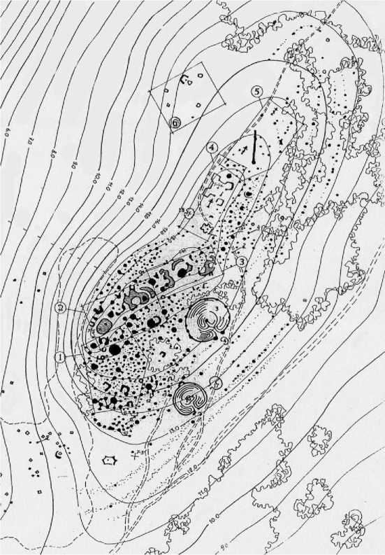
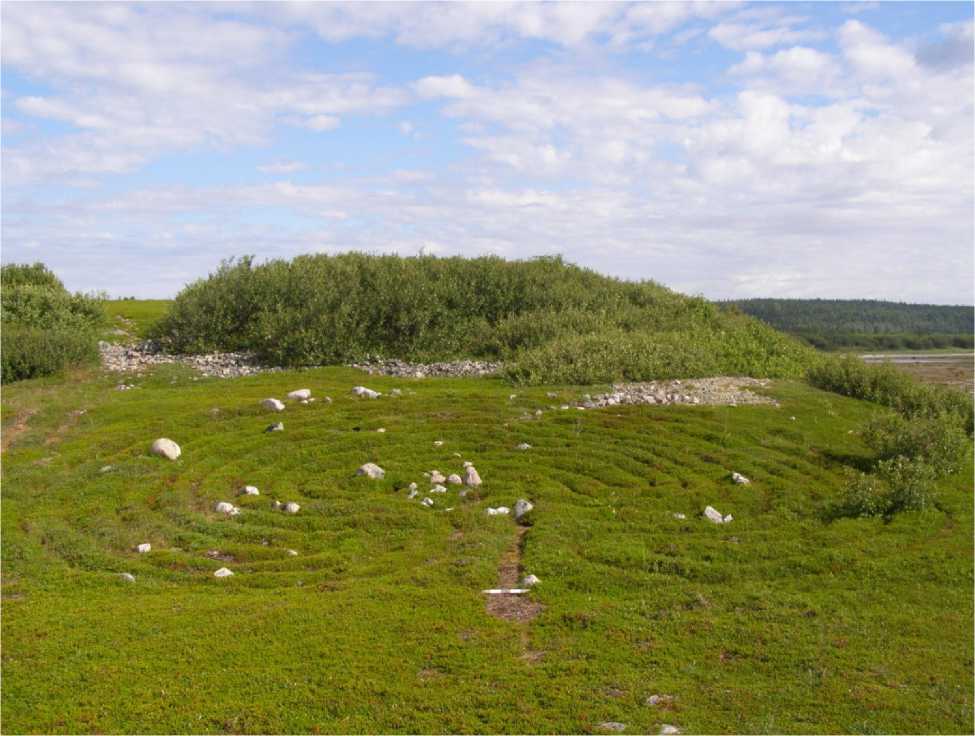
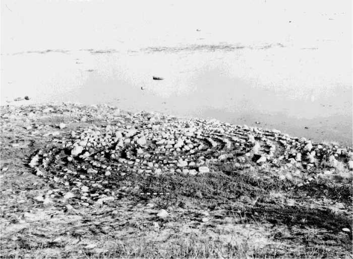
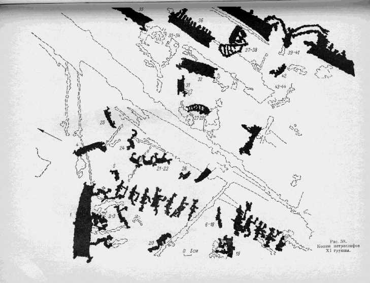
According to A.A. Kuratov "sanctuary" Solovki included "ritual and funerary monuments." Their composition may include "stone labyrinths and piles of stones, dolmens, stone ridge, and other calculations figured stone" (Kuratov, 1973, p. 73). Taking this definition as a hypothetical, it should be noted that as long as there is no steady-state study carried out "other curly calculations," the archaeologists, there are some grounds for inclusion in the alleged "sanctuaries" only part of the maze and embankments. Registered to date can be considered a "sanctuary" in B. Za-yatsky Island and Cape Labyrinths Anzer Island (preserved), as well as at Cape Fireplace between the School and Sour lips Greater Solovki Islands (demolished in the 1930s - early 1950s).
Sanctuary "B. Zayatsky Island is one of the largest in the North European part of Russia" complexes "artificial stone calculations (" cult-burial "sites), once numbering not less than 13 mazes, over 600 boulder mounds and perhaps tens of others were not significantly interpreted, artificial manipulations. Overall, B. Zayatsky Island registered 900 artificial stone additions (Skvortsov, 1990, p. 291). The main group of buildings located on the top and slopes of the Signal and includes two of the maze and about 600 mounds. Height of "sanctuary" above the level of the White Sea ranges from 13 to 18 meters. Strictly speaking, only that part of the whole "Zayatsky" assembly of artificial manipulations can presumably be interpreted as remnants of the primitive sanctuary (Pic. 15).
The basis for the dating of the end of calculations, the primitive age can be considered:
-
> Waste quartz industry, found under the mounds of excavated most of which can be dated to the Iron alleged "age";
-
> much larger size mazes number 2 and number 3 in comparison with other such calculations, indicating that other, perhaps more ancient technology;
-
> Big number of dern at the second and third mazes, as well as the adjacent rock piles;
-
> similar, similar in size, lichens, fixed on the rocks excavated mounds and labyrinths number 2 and number 3;
-
> location of this group calculations on the terrace with sufficient elevations (12-16 m above sea level), in contrast to most of the maze, located on the terraces of height from 2 to 5 meters
The remaining composition recorded in different places of the island in the form of clusters or detached mounds. All man-made structures are built of boulders and resting on moraine deposits - a powerful layer of stones. They were not excavated, the time structure and purpose of these calculations are not known.
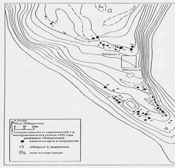
"Sanctuary" at Cape Labyrinths - a compact group of "religious and burial" of objects, among which also includes mazes and stone mounds. Addition located in the direction of the cape, on the east side of the bounding Kaporskuyu Anzerskogo Bay Islands. In the northern part of Cape intersects the east-west natural moraine ridge. Most of the archaeological sites located south of Stone Ridge, and mazes - about her, and piles of stone - along the ridge and along the eastern and western shores of the Cape. Several embankments crossing the Cape in the middle. He has a gentle slope to the sea, so that the height of the terrace to the archaeological monuments ranging from 4 to 15 m above sea level. At the present time "sanctuary" consists of two stone labyrinths and 36 mounds (Pic. 16).
Labyrinths and и embankments
So, the basic elements of the hypothetical "sanctuaries" Solovki archipelago can be expected to assume the stone labyrinths and embankments ("heap", "pile" "mounds" in the interpretation of different specialists).
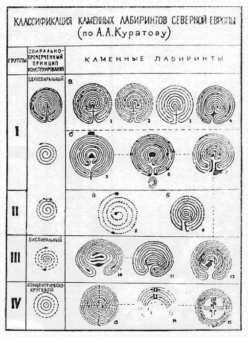
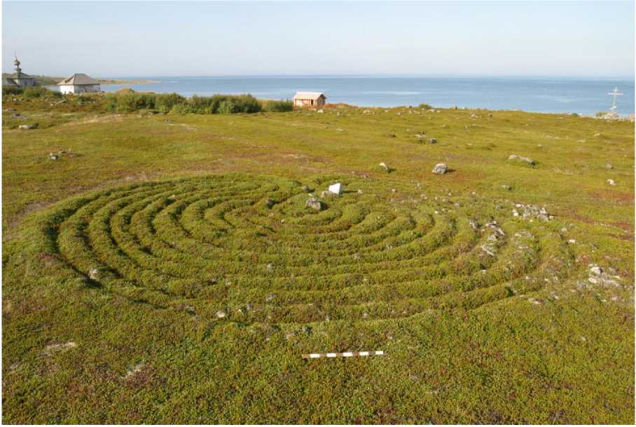
Labyrinhts typologically divided into circular spiral, horseshoe shaped, "classic" and concentric circular (Pic. 17).
Unique is the "labyrinthine" figure of concentric rectangular shapes. You must first be noted that the labyrinths B. Zayatsky island, as well as the stone embankment, do not leave the impression of a whole, and can be reasonably divided at least into two groups. The first of these are figures of number 2, 3, located on the southern slopes of the Signal in a complex with mounds (Fig. 18), the second - the rest of the calculations, which occupy a larger area of the second terrace western tip of the island.
They shared a space of not less than 150 m, mazes number 2 and 3 differ from the other additions in this category a number of significant features (much larger dimensions, the calculation of the walls in the form of a "roller coaster" and not one -two rows of stones, the presence of a large number of mounds in the structure calculations, including a pronounced central structure). The labyrinth is a number and geographically, and by their appearance intermediate between these groups of addi- tions in this category. It is a direct analogue of the maze to the number 1 pm Labyrinths An- zerskogo Island, presumably dated by archaeologists era of an early metal (Pic. 19).
Embankments are a heap of stones round or oval in shape, which can be divided into three categories according to the parameters and the presence or absence of these additional elements. Most of the mounds is characterized by medium-size (base diameter - 1.5-2.3 m, height 1 m) and large (up to than half-stack) of dern. The second group is composed of small (diameter 1.5 m and height 0.5 m) not dern heap. Some of the "mounds" before large, partly turf-covered mounds (diameter up to 4 m, height 1.5 m), which are sometimes accompanied by additional clutches in the form of so-called "fences" - in terms of the oval boulder walls - up to 0.7 m and a width of 0.8 m.
Stationary studies of stone embankments B. Zayatsky isles over the years, K.P. Reva (1907, p. 107), A. J. Bruce (verbal information), A.A. Kuratov (1969, p. 19-20) and author (2010, p. 200-207), but only the last two archaeologists managed to get positive results. Under the first of the two excavated mounds (1.8 x 1.3 x 0.75 m) at zero AA Kuratov recorded "black humus horizon in the form of lenses burned soil mixed with cobble stones, filled with ashes, charcoal and crushed calcined bones."In the same layer were found two human bones calcined (femur and tibia bones) and two quartz flakes. Disassembly of the second (small) pile (1.3 x 0.7 m) made it possible to detect an oval spot of humus with no signs of dumping. At the level of the spots were found several quartz flakes (Kuratov, 1969, p. 32). Proceedings of the excavations have allowed the researcher to consider the stone piles B. Zayatsky Island gravestones structures containing the remains of graves, "provides for cremation" (Kuratov, 1973, p. 72-73).
The expedition Solovki museum so far excavated 22 embankments, selected on a repre- sentative basis (pic 20).
Comparative analysis of materials excavated mounds gives the following picture. When disassembling small piles at the surface moraines identified in one case, a large flat boulder with a baked surface, the other seven -a layer of small stones unburned. In the six cases under the cap mounds were found quartz and quartzite flakes and chips. Exca- vation of medium-sized mound yielded largely similar, although more informative, picture. Under the three mounds were recorded soil horizons of burned to 10 cm, mixed with stones, which were found when disassembling a few calcined bones of mammals, as well as quartz flakes, cores and blanks scrapers.
The same results were gotten in the process of the research in the ruined stone embankments from the «sanctuaries» in the M. Labyrinths and M. Kirillova of the Anzerskii Island.
Thus, the materials of our excavations have substantially broadened the understanding of the nature of the stone piles. On the one hand, they have reinforced the hypothesis of A.A. Kuratov funeral appointing some of them, on the other - a problem complicated the interpretation of the stone embankments Solovki Archipelago in connection with the findings in their structure of objects that do not fit into the perception of them as "gravestones" primitive structures "sanctuary."
The main problems «funery - cult » monuments of the Solovetskii Islands.
The range of problems associated with the prehistoric archeology of Solovki Archipelago and other islands of the White Sea, was formed during the time of search and study of ancient monuments. Originally identified three main issues relating exclusively to the stone maze: Who, when and why built the data addition (Vinogradov, 1927, p. 140, 144, 149). Were later formulated the problems of classification of labyrinths and "technology" of their facilities, as well as "raised" the question of "sanctuaries" (Kuratov, 1970, p. 37-46, 1973, p. 73-76). With the accumulation of sources in the field of studies in recent decades, a problem of chronology and periodization of the monuments of primitive culture of the archipelago, the ratio of parking and the "cult-burial" of objects, reconstruction of material culture and beliefs of the ancient inhabitants of the island, features an island of culture in different epochs. In recent years, questions have been formulated about the reasons for visiting Solovki ancient people, as well as on the means, methods and routes of movement between the archipelago and the mainland (Martynov, 1990, p. 22-23, 2002, p. 94-122, 2004, p. 5 -17, 2007, p. 80-96).
The problems of dating and cultural identity "cult-burial" monuments of Solovki archipelago are closely interrelated and can not be discussed without considering this relationship. All comments made about this hypothesis in more or less unsatisfactory, primarily because of the finite time of uncertainty and cultural definitions ("date back to II-I millennium BC. E.", "Belong to the circle of circumpolar cultures," " belong to the Bronze Age, "" built in the Middle Ages "). Such conclusion is partly acceptable, as long as we think about the stone maze in Northern Europe in general, but critics call when it comes to issues of specific local cultural facilities such as "sanctuaries" Solovki archipelago. In our opinion, methodologically correct is the following statement of these problems. When construction began on the formation of labyrinths and Solovki "sanctuaries" and when the practice of their construction has been discontinued? At what time they stopped the original (old) function? What exactly geographically separate cultural group they belonged to the White Sea? Are all the mazes of the archipelago can be attributed to the number of primitive, or they were built in different eras?
Studies of the last two decades allow us to formulate a hypothesis about the "pribelomor-skom" primitive origins of the founders of Solovki "sanctuaries." The earliest discovered in their vicinity and parking Kaporskaya Kolguevskaya-1 located on the 8-meter sandy terraces. Their pottery is characterized by a comb-like ornamentation, as well as stone tools, which is dominated by silicon products characteristic of the White Sea area of Southern types. These monuments are dated in the second half of the II-I millennium BC. and most likely were related to parking Onega Peninsula this time. Topography, pottery and implements settlements Solovetskaia-1, 2, and Andrew's deserts can be more likely to associate their origin with a population of early Iron Age culture Pozdnebelomorskoy from the west coast of the White Sea.
We define a chain of "mainland parking lot « -» Island Park - "Sanctuary" link, which requires study is the relationship of some of the island sites and "sanctuaries." The work of AA Kuratov and our long-term excavations make it possible to give a number of arguments in favor of the existence of such a connection. First of all, it is of territorial proximity of parking and the "religious-funerary monuments," as well as their topography. The maximum distance between them is 0.4 km, the minimum - 150 m part of the labyrinth and the piles located at a height of 8-14 m above sea level, which corresponds to elevation sites. Secondly, this may indicate the analogs in the inventory of settlements and mounds. The collection of finds from the "mounds", excavated in the 8-15 meter B. Zayatsky areas of the island, dominated by quartz items, equipment under the mounds on the m dungeon consists of quartz, shale, and flint flakes and scrapers. Inventory Muksalma-1-1 and Kolguevskoy Kaporskoy made mostly of flint, as well as slate, quartz and sandstone, and this allows for a specified time-cultural communication. Natural (natural) in the presence of such a connection is present in the inventory-Muksalma a ritual ax, and in the collections of Kaporskoy Kolguevskoy-1 - flint figurines of game animals, as well as the discovery of flint stone sculptures of seals in the embankment near the labyrinths M. Zayatsky island.
Thus, the analysis of all available to the research of archaeological material leads us to the assumption that the complexes of the Solovki "cult-burial" sites were established in the second half of the II-I millennium BC. with the appearance of Fr. Anzer and parking Kaporskaya Kol-guevskaya-1 and, apparently, the first stone labyrinth, labyrinth, and mounds (Pic 21).
The oldest period of construction and "functioning" island "sanctuaries" has ended, apparently, in the first half of I millennium AD. Perhaps this is due to the disappearance of the early Iron Age sites late be-lomorskoy cultural group in the lower reaches of the rivers Kemi and Vig (Kosmen-ko, 1991, p. 212-213). с. 212-213).
All other labyrinths, which
are located on the terraces of height from 3 to 5 m and is not associated with stone embankments, could be posted no earlier than the Middle Ages (Pic 22).
The most difficult and complicated problem Solovki "sanctuaries" was and remains the question of their appointment. Do not forget about the controversy of interpretation of clusters of mounds and labyrinths as a primitive "sanctuaries", it is essential to allocate her two aspects: the appointment of a "sanctuary" as a complex of burial and ceremonial objects and purpose of labyrinths as one of the elements of the "sanctuaries." It is equally relevant to the nomination of the so-called "single" maze, laid out in the field of fisheries and related marine animals (Cape Beluga, Cape Kirillov).
So far, the only archaeologist who studied the problem of special-purpose "religious-funerary complex" Solovki Islands, has been and remains AA Kuratov. The researcher notes that "the shrine visited by people for the burial of the dead, as well as for the administration of various rites of primitive religion ... There have been hunting and fishing, and fishing magic ... conducted initial operations" (Kuratov, 1973, p. 73, 1974, p. 18 -20). Agreeing with this view as a hypothetical, it should be noted that the new archaeological materials can add to it a number of important considerations. First, we note that the formula "the burial of the dead" does not disclose the na- ture of the rite and does not provide information about the sequence of operations may be made at his departure. Analyzing the entire set of data obtained during the excavation of stone mounds, one can not ignore the significant differences in a set of cultural remains. In some cases (OB Za-yatsky) there is reason to believe that the mound was built over the decomposed and burned at the site of the sanctuary a symbolic funeral pyre (the cultural layer of charcoal, human-centered pits and waste management industry, quartz), remnants of which were strewn with shells of mollusks . The other (labyrinths of. B. Zayatsky) the entire ritual would be to be placed on a platform of the future "mound" or unfired calcified bones of mammals, quartz, and subjects them to lay the boulders. In the third, where it was laid out on the operation of the stone heap on the moraine ridge. The presence of "barrows" spaces of bones of mammals and birds permits the assumption of sacrifices, committed in the process of burial and is probably part of the rite of burial.
The list of possible rites of primitive religion, committed to the maze, researchers including actions related to the cult-commercial magic and initiations. Justification first saw Gurin NN (Gurin, 1948, p. 126-142):
-
> at the location (some - AM) labyrinths on the coast in places developed (by ethnographic data) of sea fishing;
-
> — in the similarity calculations with some traditional fishing projectiles (eg, kill, and Venter);
-
> the choice to build a maze coastal areas, resembling in form the outer contour of horseshoe-shaped labyrinths
These characteristics also apply to some island of addition (in the m Beluga, Cyril M.), with the difference that the traditional mammals and fishing in these areas have been artificially interrupted in the first half of XX century.
In general, agree with this assumption can be one important caveat: we have in mind only a single (not accompanied by stone embankments) maze, located near the sites of sea fishing.
With regard to the rite of initiation, the author of the hypothesis VR Cape justify it, given the archaeological analogues, distribution of such facilities in Australia, Aboriginal people who served for the rites of initiation. In general, the hypothesis is based on the general philosophical understanding of death as a rite initiate and returns it to a new life (Cape, 1969, p. 309-314).
Various ceremonies of primitive religion, which could be committed to "sanctuaries" are probably not confined to religious-magic and initial commercial operations. Findings in the cultural layers of parking lots and near the "sanctuary" B. Zayatsky island figurines game animals suggests the hypothesis of the existence of the inhabitants of the island settlements - the creators of "sanctuaries" - sea fishing worship animals - seals, and (or) the beluga. The presence in the beliefs of the population of the island is a natural element of totemism, and due to the fact that his life is largely dependent on the success or failure in the maritime industry (fat, skin, meat, seal). Could play an important role and the fact that it is the white whale and the seal were the representatives of the fauna in the White Sea, which has the strongest emotional impact on the primitive inhabitants of the archipelago.
A small number of sources make it possible to include in the hypothetical number of their beliefs, worship the sun god. On a certain probability of existence of the cult of the primitive belief in the White Sea population showed, in my opinion, some petroglyphs Zalavruga (Savvateev, 1970, p. 66). To perform rituals of worship to the sun-god in Solovki, may indicate some of the stone composition of the archipelago, as well as the very conditions of life and economy of the ancient population of the coast and islands of the White Sea. Seasonal hunting, fishing, sailing for long distances, harsh climate conditions in which the sun was one of the few sources of heat and light, as well as a guide for determining the direction of movement, there were compelling prerequisites for the treatment of Aboriginal people as the supernatural power of the sun, people who awards heat and light.
But could there be something to do with the cult of the sun to the Solovki "sanctuary"? A positive answer to this question is justified, given that the two types of Solovki mazes correlate well with the sun. Labyrinths of these types are one spiral structures, which follows the outer wall of the circle and concentric-circular shape in the form of a system, each refined stone rings. If other than a close resemblance to consider the fact that the "sanctuary" located on the headlands, which are seen from a sunrise or sunset, it can be assumed that some of the mazes and symbolic figures in the shrines were built for the administration of ritual action, the proper cause disappearing from time to time shining. Construction on the shrines of stone symbols of the sun is quite acceptable for many days of absences during the last hunting season, a cold rainy summer, and in other adverse situations.
So, the old "sanctuary" could be places where the place of the "ritual" of life of the primitive inhabitants of the White Sea. Presumably they were committed ceremonies connected with the symbolic burial of the dead, the worship of ancestors, hunting and fishing magic, initiation, worship the sun god, and perhaps others not identified or understood, magic acts.
* * *
In light of the foregoing, it becomes more certain and the appointment of stone labyrinths of prehistoric items as "sanctuary." It should be noted that in the scientific literature, there are a number of different hypotheses about the appointment of these enigmatic structures, and the vast majority of their views as a maze of objects that are functionally related to other ancient artificial structures. This circumstance led to the vulnerability of the assumptions and the impossibility of their distribution to all sites in this category. Without going into an analysis of existing hypotheses concerning the appointment of mazes (this is done Kuratov A.A.), one should first of all, notice that the original, ancient, and the later Middle Ages, the appointment of stone labyrinths in Northern Europe was obviously different. Most likely, the different functions of mazes located groups and accompanied by mounds of "sanctuaries" Solovki Islands, on the one hand, and individual labyrinths of the archipelago and the Kola Peninsula, on the other. Ambiguous it seems the use of single figures and clusters in the labyrinths of burial cult complexes Solovki Islands. We can not exclude also the specific function of different types of figures. Different functions can perform maze and in the process of committing various ceremonies of primitive religion.
Archaeological materials are not allowed to reliably identify the function of ancient stone labyrinths, however, allow us to formulate some ideas on this subject.
As a symbolic burial place of Solovki islands were chosen is obviously no accident (which was easier and safer to bury the dead on the mainland), and in connection with some ideas about the afterlife1 and the death. In analyzing the likely sequence of steps in the process of "funeral," one can agree with the assumption N.N. Vinogradova, that they were committed with a conscious purpose - to provide a non-return of the deceased or his soul from the afterlife, which is at such ideas about death could be perceived alien and hostile . But the presence of mounds near the labyrinths, which are a system of intricate passages, suggests that in their understanding of these procedures were insufficient. Probably for the administration to another world and could constructed, primarily, those figures have undergone at Solovki evolution from the simple (circle and spiral) to a much more complex ("classical"). From this it follows that the Solovki stone labyrinths "sanctuaries", built on the border of two worlds, can be symbols or hereafter - "the bottom" - a world in which entangled souls of the dead, or the way in it. This conclusion is consistent with the common in the ancient northern European views of the islands as a "staging" areas on the way to the "land of the setting sun" (Ravdonikas, 1940, p. 61), where the ancient mounds were formed with different, sometimes very specific, burials (Deer Island on Lake Onega) (Gurin, 1956, p. 47). In this symbolic role could be, in our opinion, the main function of labyrinths, implemented through the magic of special operations.
The second, more concrete and materialized purpose data structures in the sanctuary lay, apparently, in their use of magic as a tool to perform various rituals (dancing, fortune-telling, divination, communication with spirits, etc.)
Who, why and how went to the islands in the ancient times»?
Examining the ancient island parking area and comparing them to the topography, pottery and stone tools from the materials of known settlements of the time on the mainland, we are easily found in only two analogues, but the most important for the understanding of ancient historical situation in the White Sea, places. This - the west coast, the lower reaches of the rivers Kemi and Vig to the surrounding areas, as well as the Summer White Sea coast. And the elevation and location of parking areas on the moraine and sand, and geomorphology (a thin, weakly stained cultural layer), and stone implements of mainland and island sites are similar. The very geography of (the existence between the west coast and the body of many islands, separated by distances of 0.5-1.5 km) eliminates any doubt that the pioneers were the inhabitants of the islands, and Kem late Mesolithic and early Neolithic settlements (Martynov, 1995, p. 68-79; Manyuhin, Lobanov, 2002, p. 19-27).
So, the first islands discovered in ancient times in the White Sea, were closest to the mainland Body, and should be considered the pioneers west coast of the population that lived there from the VII millennium BC.
Opening of the Solovki archipelago was also in the Mesolithic. In addition to the equally expressive analogies between the two parking lots adjacent archipelagos, as indicated by another circumstance, as now, in ancient times as a goal Solovki voyage was visible only from the rocky peaks of German and Russian bodies, and even with the arrows of the Onega Peninsula - Cape UHT-Navolok . But on the Onega Peninsula, no Mesolithic or Neolithic sites with quartz stock, and a few dozen meters from the rocks of the German Body has already been excavated village and a workshop this time (pic. 23).
Yes, and without any sensible person of archeology it is clear that ancient people could explore the White Sea island only on the principle "from the mainland - to the nearby island of it - to the next and so on," going to the apparent target distance sea travel. The oldest by sea from the mainland to the Solovki Islands, which exists in the middle of VI millennium BC and to this day, is the "West": the lower reaches Kem Body through the archipelago (pic 24).
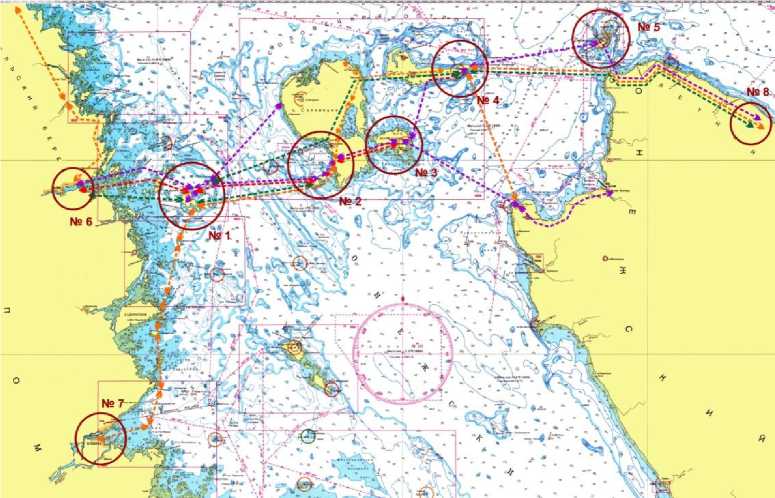
Of particular interest is the question of the root causes of the opening of the Solovki Archipelago, which, of course, was dangerous and risky business. Traditional archeology is the view that the migration to new lands in ancient times were caused by the disappearance of most of the object of hunting - the beast and the need to search for untapped, rich in game animals and fish areas. In this situation, when one of the objects were hunting marine animals, such a cause can be considered possible if the hunters have observed in the body of the migration of seals or whales in the direction of the Solovki archipelago. However, to be the main cause of the dangerous walking "across the sea," it could not, it was much easier to produce and forestry, and marine mammals along the coast. Much more represented a different root cause - inherent in human nature at all times, inquisitiveness, curiosity, overwhelming desire to consider the dark stripes near the far shore. Watching from the rocky peaks of German Bodies are weird, viewed only in clear weather, the rise on the horizon, they could decide, and decide on the first trip. The important fact was, and their experience of coastal navigation (Kem between the islands and the body), the existence of which no doubt.
***
An interesting problem, the solution of which depends largely on the reliability of our understanding of the primitive navigation is a reconstruction of the vehicles on the White Sea. Terms of archaeological sources for this very narrow and not indisputable, however, and they provide a basis for formulating hypotheses.
First of all, this stone "anchors," or, more precisely, the "anchor stones" found in the cul- tural layer of the Solovki camps-4-2 and Muksalma Kolguevskaya-2. "Anchor stones" are a slate or sandstone slabs with slightly prominent or well-defined (in Kolguevskoy-2) grooves, performed on opposite sides for the tench, which joined rock the boat. Dimensions "anchor stones" ranging from 32 x 30 x 4 to 44 x 31 x 5 cm, weight of products - from 5 to 18 kg (Pic. 25).
A separate group of sources is the stone tools, used for logging and wood processing (chopping tools, scraper, scrapers), hunting for marine animals (spearheads, axes, hunting) and the processing of skins (knives, scrapers, borers). This category of sources in one way or another is present in most of the settlements of the Stone Age and Early Metal.
Important sources for the re- construction of marine vehicles can be considered as one category of rock art found in the lower reaches of the river Vyglodki. According to its Karelian researchers Professor A. Savvateeva (1970, p. 92, 172) and in concert. Mr. Zhulnikova A.M. (2006, p. 143-144), among the White Sea petroglyphs were depicted and framed dugout boats that could carry the 1 to 24 man (Pic.26)
Now available to archaeologists, sources indicate the two most likely way to get around on the White Sea in ancient times: in the frame boats and boat-dugout. But indicate only indirectly. Looking for additional arguments in favor of this hypothesis could be done one of two things: either to find the remains of boats in the cultural layer of the island sites, or build such
a boat and go at them from the west coast to Solovki. Because wood and leather in the sand of the primitive sites Solovki islands have not been preserved, are experiments.
In 2009-2010 the White Sea were carried out two experiments. Their participants: employees Solovki museum-reserve A. Martynov, SB, and A.L. Balan Sharkov, People's artist of bark A.V. Shutihin (Kotlas), a master wood A.A. Kazakov (the village of Borodino Ustyansky district of the Arkhangelsk region), and their associates.
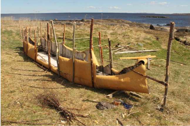
Experiment № 1: frame boat «berestyanka»
Construction of the "sea" frame boats and pilot tested it in the White Sea was carried out in several stages.
Step 1. Procurement of material (birch bark, pine root, resin and branches of conifers and deciduous trees).
For the manufacture of boats needed a young, flexible, crack-free and the "evils" of birch bark with a minimum thickness of 3 mm. Material should harvest in late May - early June, when the crust is moving away from a good barrel. The removed bark should be twisted together into a roll and stored in this form prior to construction. Can be considered an ideal case where the construction of the boat starts immediately after harvesting, while elm is still wet. Cortex of two birch trees with a diameter "in the butt" is not less than 30 cm is enough for one boat.
The branches of the firs go to the ribs and the upper edges of the boards ("frame"). To "frame" must be 8 long (over three meters), gently curved at the base of the branches with a diameter of 4 to 5 cm frames are used for branch length from 1 to 2 m thick and 2.5 cm. All the branches selected for the construction, must be cleaned of bark and twigs.
To form a gasket between the birch and fir paneling frames can be used long (2-2.5 m) and thin (1.5-2 cm) of young stems of deciduous trees, pre-"barked" (partially released from the cortex and completely - from knots). Provisional title of these boat are the parts – stringers.
Harvesting pine root most easily in the sand to make (bor) terraces, which are generally located north parking lot of the Mesolithic and early metal. The root of the pines exhibit at a distance of 23 m from the tree at a depth of 5-10 cm thickness of the root should be from 5 to 15 mm. Before use, the root soaked in water, purified from the bark and split in two.
Fir resin is collected on the ground in spruce stem damage (a broken twig, a natural fissure, etc.). To use the good and the dried and fresh resin. When heated, it melts and adds it to any animal fat (pork, goose, seals, and whales). The standard ratio of 10 parts resin to one part of the animal fat.
Step 2. Building.
For the construction of boats used simple tools: an ax, a knife and an awl. On the ground, the contours of the bottom of the next boats were driven stakes height of 60-70 cm, birch bark laid between the sticks and stones pressed to the ground. To the bottom of the boat used very long, tough pieces of birch bark (3 x 1 m). They sewed the pine root on top, additional pieces of bark, which formed the sides (pic 27).
The top sides clamped between two thick branches of the top "frame," which tied with pine roots. After 60-100 cm the upper side joined together by six transverse 'ties', which later served as a backrest for the rowers. Frames placed every 7-12 cm, resting in the side. Between frames and birch bark laid "stringers", fashioned thus, the second - wood - the bottom and the second side. The seams on bark cloth missed spruce resin. The working group composed of A. Shutihina, A. Polezhayev, V. Yarysh, A. Martynov, J. and M. Dubrovsky Hohlinoy built a "sea" boat for three days (Pic. 28).
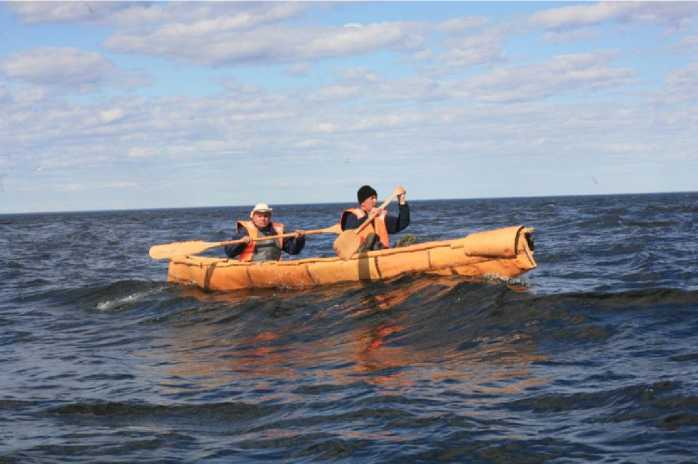
Period 3. Go along the route of Kem (Port) - Body - Solovki
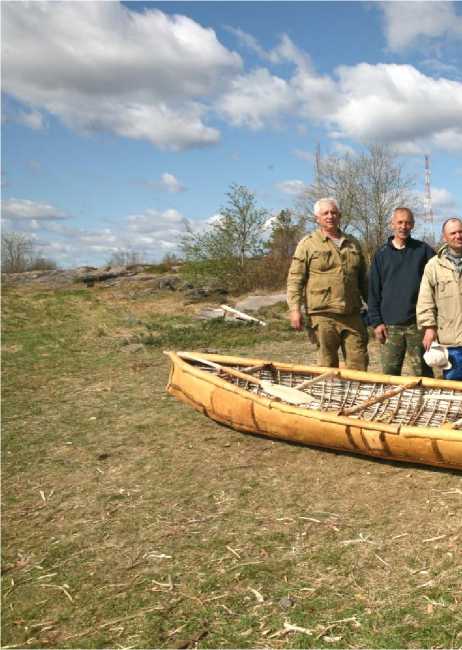
The transition from Kemi to Fr. German Body (about 23 km) was carried out for 6 hours with an average speed of 3-3.5 km / h with two short (15-20 minutes) stopping at intermediate islands, which were caused by the need to pour out the accumulated water in the boat and the "stretch feet "paddlers (A. Martynov and A. Shutihin).
The first two hours of transition coincided with the mean low water phase, when the flow velocity is greatest, so at this stage was recorded maximum boat speed - 6 km / h. Rest of the way I had to go in a situation where, on the one hand, the movement contributed to gradually weaken during the ebb, and the other - it prevented a headwind, so the boat speed dropped to 2.5-3 km / h. Depending on the location of the boat wave height ranged from 20 to 80 cm, and the direction -from the "bow" to the board. These circumstances complicate the movement, but at the same time, allow the possibility of faith-boats in the natural environment of the White Sea (pic. 29).
After a brief stop on the island Nemezkii in submarine Body has set its sights on the island of B. Zayatsky Solovki archipelago. The movement on this, the most complex and lengthy, the way the site was complicated by two factors: a strong head wind and the fatigue of a long day. For these reasons, managed to get two and a half hours of the most difficult part ("Suvorov" between Fr. Oleshin about. B Top), as part of the way to the Gulf Wealth Pesey ludy done "in tow." The final section of this part of the journey was passed in a boat without interference .
During the summer of 2009 on it occasionally went to the Holy Lake. In July, the museum staff Alexander Martynov and S. Balan has been successfully passed a route length of about 10 km from the royal pier B. Solovki islands of the harbor. B. Zayatsky.
Experiments № 2: boat - dolbenka
Step 1. Harvesting of the materials.
According to ethnographic data, the only kind of deciduous trees, of which the XIX-XX centuries. Produced in the North dugout boat ("odnoderevki") was aspen. This explains the origin of the name of another northern dolblenok - "Osinovka." The modern practice of building dolble-nok suggests that "Osinovka" size 4.5-5 m is capable of carrying no more than 3 people, boats of greater length on the rivers is not just built, it was not necessary. For the construction of "marine" version dugout were pre pared two aspen stem length of 10 m and 80 cm in diameter in the field saw cut.
Step2. Building of the boat - dolblenki.
"Marine" version of the dugout boat ("Osinov-ka", "odnoderevki", "kamya-gi") was executed by order of the Solovki museum master A.A. Kazakov in 2010. Assistant foreman in the con- struction of the boat were his countrymen A. Ipatov and author of the article.
The main periods of the work (pic 30):
-
> exemption from the bark of the trunk (okarivanie) in the warm season, when the bark is detached from the shiny surface of the wood with a crackle;
-
> markings on the trunk of the future boat, with an overlap on the crop and at its end;
-
> registration form bow and stern of the future boat;
-
> gouging a steel timber (in ancient times - quartz, flint and shale) with an adze on the principle: first, the central part, and then the side;;
-
> cleaning inside and outside of the boat a steel scraper (in ancient times it could be done with stone scrapers and scraper);
-
> Phased wiring boards to the required width by heating to boiling water poured into the ship (in ancient times - putting hot stones into the water) and bursting with thick sides with fir branches;
-
> Installation of frames of spruce branches bent by attaching them to the ledge - clamp;
-
> drying and impregnation of the boat seal fat.
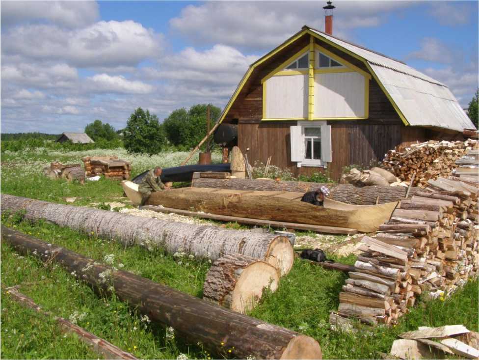
Parameters of the "sea" boats: length - 8 m, maximum width - 1.2 m, depth of 40-45 cm, weight -200 kg load capacity - more than 1.2 m According to our data, a boat of this size built Archangel on the north for the first time in the last two centuries.
Step 3. Test of the doblenki in the conditions of the White Sea.
Invaluable assistance in the implementation of the project was provided by the sponsor company "Ecological Technologies" (leader - Y. N. Rogachev, pos. October Ustyansky district of the
Arkhangelsk region), have provided the master source material, as well as deliver a boat manufac- tured over 1200 km to the west bank of the White Sea (in pic 31).
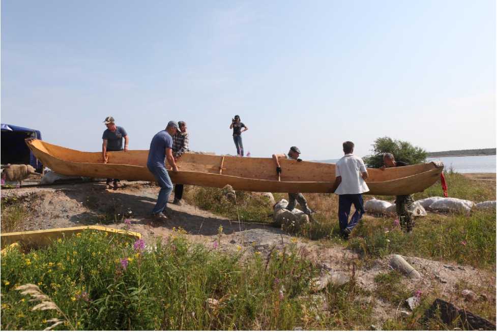
In the process of building boats formed a crew consisting of six persons: A. Martynov - the captain and the helmsman, S. Balan and Sharkov (Solovki), A. Kazakov and Y. Rogachev (mouth), Denisov (Moscow). Tests of the boat, dugout held in July 2010 in different weather conditions: with a tail, a head and side winds up to 5 m / sec downstream and upstream, against the tide and wind, the wave height of 30 cm and calm. We worked with five oars, allowing paddlers to rest in turn. The transition from Kemi (Port) to a. German body was carried out for 6 hours with a short (20 minutes) rest in one of the Kem islands (Pic 32).
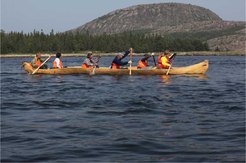
Due to strong winds and high waves in the area of Zayatsky, and not being able to stay on bodies until the next day, this part of the route the boat was dragged on a tow boat for the museum Pechak, ensuring at the same time its ability to float in a wave of up to 1 m in height and flow rates up to 8 nodes.
The transition from the harbor to the XVI century on Zayatsky to the monastery of Solovki islands dock was carried out during calm weather for two and a half hours. The maximum speed recorded at the site, and was 8 km / h.
* * *
Observations of the "behavior" of boats, carried out in the process of transition, led to several conclusions that are important to the practice of walking on the White Sea on so small and fragile vessels:
-
1) The bark and dugout boat is stable, provided that the seats for the rowers and passengers are at the waterline (the lower the seat, the more stable the boat). The degree of stability depends also on the total weight of the rowers, and weight (more weight, more stable boats);
-
2) The speed depends on several factors. Maximum speed (6-8 km / h) reached the boat moving in a line of the main flow, the minimum (1.5-2 km / h) was recorded during the motion against the tide and wind in the strait between the islands of Russian and German Body. The average speed was 3-4 km / h;
-
3) the motion of the sea in a frequently changing wind (primarily between the islands), you must use different methods of rowing in the dugout: pairs of oars with a tail or head wind, the three (or four), rowing against a crosswind, the oars with all five one side with strong gusts of wind drift;
-
4) The holding of the specified rate on a heavy boat, dugout, in contrast to the light frame boat, you need to constantly work the steering oar, and to monitor and regulate the work of the rowers;
-
5) and "canoe" and dugout boat "cut" the oncoming wave, wave board up to 50 cm in height
raises and lowers them when they met with a wave "in cheek" in the boat gets a small amount of water;
-
6) by impregnating the bottom and sides Spruce gum and seal fat boat passed a small
amount of water ("canoe"), or does not pass water, get into the dugout, it can only be through the side;
-
7) on the bark boat length 5.5m to walk of 3-4, the dugout 8 m long - up to 12 people.
* * *
Thus, experiments were carried out Solovki museum – reserve, masters A.Shutihinym and A.Kazakov, and the working group and the crews have proved the possibility of building birch bark frame boats and boats –dolbenok and sailing by them in the White Sea in any of them was studied by archaeologists in the North eras. They also confirm the authenticity of images of two types of boats in the petroglyphs Zalavruga (made in the technique of a continuous contour, and a knockout), and the validity of their interpretation as a frame and hollowed. As the historical evidence of the existence of such a practice in ancient times could only serve the immediate archaeological sources - fragments of birch bark and wooden boats dolblenok associated with primitive parking and perhaps the areas adjacent to them (eg, marsh, adjacent to the terrace on which there are six ancient sites marked with the names "Solovki-4, 5, 6, 13, 15, 21 '). Given the small area of the excavated sites (no more than 10% of the total area of the cultural layer of the primitive sites White Sea), it is hoped that such sources will appear in the future steady-state operations. As for the boat with rocker and sail catamarans and other "small size" of vessels, the possibility of their use on the White Sea also be verified experimentally. Leather boat is built, and tested in the White Sea was planned in May 2012.
* * *
As revealed in the course of our work, the answers given by other sites - lost in the woods and hidden under the tundra lichens prehistoric campsites and workshops. If the maze is still a mystery to all, the settlements and artifacts as you can see, it is able to reliably tell us about the prehistoric past, the famous archipelago.
References The islands of the White Sea, from the Mesolithic to the Middle Ages (the ancient development of the White Sea islands on archaeological data)
- Bruce A. J., Stone, MP Zimin perforated battle-axes in the territory of the European part of USSR / / Code of archaeological sources. No. B-4. - Moscow: Nauka, 1966.
- Vinogradov, N.N. Solovetskie mazes. Their origin and place in a number of homogeneous prehistoric monuments / / Proceedings of the SOC. Volume VII. Solovki, 1927.
- Vinogradov, N.N. New mazes Solovki archipelago / / Proceedings of the Solovki Society local history. Volume XII. Solovki, 1927.
- Gurin NN Stone labyrinths of the White Sea / / Soviet archeology. - 1948. - № 10. - P. 125-142.
- Gurin NN Oleneostrovsky repository / / IEA, 1956.
- Demidov I. The history of the landscape reserve "Body" in the White Sea in the late-and post-glacial / / Cultural and Natural Heritage of the White Sea islands. Petrozavodsk, 2002.
- Zhulnikov AM Petroglyphs of Karelia. The image of the world and the worlds of images. Petrozavodsk,2006.
- Cape VR The origin and early history of Aboriginal Australia. M., 1969.
- Kodolov O.E., Sochevanov VN path of the labyrinth. St. Petersburg, 2003.
- Kolosova, G.N., Novikov VS brief physical and geographical characteristics of the island of Great Muksalma / / Solovki Islands. Most Muksalma. M., 1996.
- Kosmenko MG genesis and chronology of the cultural formations of the Iron Age in southwestern and northern Karelia / / The chronology and periodization of the archaeological monuments of Karelia-workers. Petrozavodsk, 1991.
- Kuratov A. Proceedings of the archaeological expedition AOKM and ACRI them. MV Lomonosov Moscow State University in 1969 / / Archives AOKM. 462a.
- Kuratov A.A. stone labyrinths in Northern Europe. The experience of the classification / / CA. - № 1. - 1970.
- Kuratov A. Stone labyrinths Arkhangelsk White Sea. On the appointment of labyrinths in Northern Europe / / Historical and Regional Studies collection. Vologda, 1973.
- Kuratov A. On the appointment of an irrational stone labyrinths in Northern Europe / / Problems of the Soviet Finno-Ugric. XV All-Union Conference of the Finno-Ugric. Abstracts. Petrozavodsk, 1974.
- Kuratov A.A. Solovetskie maze - the ancient monuments of culture in Northern Europe / / Culture of the Russian North. L., 1988.
- Manyuhin IS, Lobanov NV Archaeological sites of the archipelago Body / / Cultural and Natural Heritage of the White Sea islands. Petrozavodsk, 2002.
- Martynov, A. J. Some problems in the Solovki sanctuaries / / the study of historical and cultural environment of the Arctic. M., 1990.
- Martynov, A. J. Primitive Bodies parking lot of the archipelago in the White Sea / / Bulletin of the Karelian Museum. Petrozavodsk, 1995.
- Martynov, A. J. Archaeological monuments of Solovki Archipelago and other islands in the southern part of the White Sea. III millennium BC.. - XV century. Arkhangelsk - Solovki, 2002
- Martynov, A. J. Prehistoric archaeological past of the islands of the White Sea: Results and problems in the study / / Journal Pomeranian University. Number 1 (5). Arkhangelsk, 2004.
- Martynov, A. J. Ancient Paths Solovki Islands. M., 2006.
- A. Martynov, J. On the beginning of the Northern Maritime (according to archaeological sources) / / Russian culture of the new century: problems of study, preservation and use of historical and cultural heritage. Vologda, 2007.
- Martynov, A. J. prehistoric archeology of islands south of the White Sea. Arkhan-Gel, 2010.
- Okorokov, AV ship anchors. M., 1986.
- Ravdonikas VI Neolithic burial site on Lake Onega / / CA. - 1940. - № 6.
- Reva K., On excavations in 1907 / / KLA in 1907
- Savvateev A. Zalavruga. Archaeological Site of p. Vig. Part 1. Petroglyphs. - L.: "Science", 1970.
- How Skvortsov AP sites in Solovki? / / The study of historical and cultural environment of the Arctic. M., 1990.
- Kheladze I. A brief sketch of the geological structure of the Solovki Islands / / Proceedings of SOAOK. - 1926. - Issue 1.
- G. Shvartsman, I. Bolotov, etc. The environment Solovki archipelago under the conditions of a changing climate. Ekaterinburg, 2007.
