The potential for integration of the transport complex of the east of Russia into the international market of transport services

Author: Bardal Anna B.
Journal: Economic and Social Changes: Facts, Trends, Forecast @volnc-esc-en
Section: Branch-wise economy
Article in issue: 6 (66) т.12, 2019.
Free access
The eastern regions of Russia are the convenient zone in which Russia cooperates with the actively developing Asian region. The key states of North-East Asia such as China, Japan, and the Republic of Korea are the largest participants in world trade at the present stage. The servicing of large-scale commodity flows with the European Union and the U.S. is provided by the market of transport services, by means of which the most effective schemes of delivery are built. Under these conditions, the transport system of the East of Russia has objective prerequisites for integration into the international transport system. The goal of our present study is to assess the potential of integration of the transport system of the Far East in the market of transport services in North-East Asia. At the same time, we assess integration opportunities with the help of dividing the territory of the East of Russia into districts based on the results of cluster analysis. Considering the achievement of the research goal, this approach is a new one. The need for division is due to the fact that the Far East is quite a large region, extremely heterogeneous in its internal composition, economic-geographical and socio-economic characteristics. Constituent entities of the Russian Federation as part of the Far Eastern Federal District have, among other things, different integration potential and level of development of the transport system. In the course of cluster analysis we use indicators of transport network development and the scale of foreign economic activity as the criteria for division. As a result of our calculations, we divide the Far East into five regions that differ in the potential of integration interaction of the transport system with the market of transport services in North-East Asia. The paper presents specific features of the selected areas, characteristics of transport systems and prospects for participation in the international transport market. In the future, it is possible to conduct a study taking into account the projects for development of the transport system of the Far East, which adjust the prospects for integration interactions.
Integration, transport system, russian far east, cluster analysis, northeast asia, transport services market
Short address: https://sciup.org/147224228
IDR: 147224228 | UDC: 332.1+339.924 | DOI: 10.15838/esc.2019.6.66.8
Text of the scientific article The potential for integration of the transport complex of the east of Russia into the international market of transport services
The boundary position of the Eastern regions of Russia creates preconditions for interaction with large-scale economically developed countries in the Asian region (China, Japan, Republic of Korea). These countries to date have developed trade interaction with the global economy and extensive transport links serving the trade. Thus, by the end of 2018, the total merchandise exports of PRC, Japan and Republic of Korea have amounted to 3.8 trillion US dollars, imports amounted to 3.4 trillion US dollars1. While the most important trade partners of the leading Asian countries are the United States and the European Union.
The Far East of Russia geographically belongs to the North East Asia (NEA), having the preconditions of integration into the ongoing processes. Under these conditions the transportation system in Eastern Russia in collaboration with the international transport system could participate in the service trade flows of the countries of the North East Asia. The active involvement of the Far East transport system into the international transport market can be considered as a potential driver of economic development in the Eastern regions corresponding to the actual directions of Russia’s state policy at the present stage. To date, however, the extent of such participation is negligible.
The purpose of this research is to assess the potential for integration of the transport system of the Far East in the transport market of the North East Asia selecting the areas on the basis of cluster approach. The scientific novelty of the conducted research the results of which are reflected in this article is the analysis of the integration potential of the Russian transport system on the testing ground of the North East Asia, as well as the possibility of increasing the degree of diversity, respectively, sustainability and efficiency of the international transport integration systems currently designed in the North East Asia. The use of cluster analysis is an element of the novelty allowing to expand the range of instrumental methods in achieving this goal.
The work on fundamentals of economic integration do not directly affect the problems of transport maintenance [1; 2; 3]. The presence of a transport infrastructure is assumed as one of the elements supporting the integration processes when considering different forms and levels of integration.
The close study of transport systems integration processes in modern literature is associated first and foremost with the construction of effective interactions in United Europe. In this context, we discuss the issues of interlinking between the transport systems of individual countries in the framework of the common transport system of the European Union (EU), in particular the effectof individual types of transport on the environment and the identification of the most extensive issuers of pollutants in the transport sector. The negative impact of road transport and the relevance of the application of measures to reduce carbon emissions in the medium term (the period of 2020-2030) are emphasized. According to the estimates the delay of the processes of decarbonization of the transport system will lead to an increase in the cost of this process in the framework of the EU in the period after 2030 [4; 5]. The dynamics of transport emissions in the European countries, the largest emitters of hydrocarbons, including the calculation in the context of cross-sectoral linkages is estimated [6].
Border crossing is one of the most important issues when considering the integration of transport systems. This problem is also most evident on the example of the EU. In the current literature the spatial characteristics of network development and other determinants of transport mobility in transboundary movements of the United Europe, including transport corridors, are being discussed. The availability of adequate transport links is one of the key factors contributing to the creation of a common economic space. We propose to evaluate the boundaries’ permeability using the ratio of the demand and supply for cross-border movements along the routes of the used modes of transport, and to consider the integration of transport systems in transport corridors as the process of achieving sustainability from the point of view of not only the environment but also the socio-economic development [7; 8; 9].
Another research direction is the field of transport systems integration refers to the inclusion of the former Soviet republics into the global transport space. In the publications of the comparative advantages of transit routes of Central Asian countries and the Eurasian Union, estimated the magnitude and direction of transport links and promising options for the transport projects of the Eurasian economic Union [10; 11; 12].
In the scientific papers concerning integration in the NEA including those from the point of view of transportation systems the possible effects of creating different conditions of operation, the application of measures of state regulation, the reduction of ecological load on the environment are discussed [13; 14; 15]. Thus, for air transport relevant in the absence of a single terrestrial networks between the countries in the region, the competitive strategies of key airports, network vulnerability settings, the consequences of the introduction of “open skies” by the leading northeast Asian countries are examined [16; 17]. The positive effects for both the users of air transport services, and the airlines in the case of air transport market liberalization are shown. The policy of space distribution for domestic and international flows in airports is revealed as an important complementary measure. The operational stability of the airport network in NEA and the units that are mostly exposed to risk are determined [18; 19].
The research on the problems of development of maritime transportation, serving trade flows within the northeast Asia region, and economic relations of the countries of the region with the world are devoted to the analysis of development trends of the key states’ ports, the strategies of cooperation in the field of maritime transport. Thus, when comparing the competitive advantages of container sea ports of the three leading northeast Asian countries – China, Japan, Republic of Korea – we have identified (20 criteria were selected for evaluation and experts’ survey was conducted) the leading market position of Busan port [20]. The transition from competition between ports to cooperation in individual countries is noted. It is shown that in Japan, the expansion of sea ports’ cooperation allows using the existing capacity more efficiently, and public and private financing of targeted investments in new assets [21]. The strategy of cooperation of sea ports in China is being considered, where encouraging methods and the possible implementation schemes are elaborated by the government at national and provincial levels [22; 23].
Description of the research methodology and substantiation of its choice
The question of assessing the potential for integration of the transport system in the Russia’s Eastern regions into the transport market of the North East Asia is debatable, its solution may not be simple and straightforward. First, the study object seems to be difficult – the transport system of the Far East including different types of transport operating in the territorial systems differ in their internal characteristics, interaction and communication between them and other agents of the transport services market and the economy as a whole. Secondly, the study is complicated by the instability of the situation arising in the process of transformation of individual elements of the transport complex of Russia, and under the influence of fluctuations of economic systems (at the national and international levels).
The first of the above-mentioned circumstances leads to the consideration of the potential for integration of the Far East transport system without taking into account inner differentiation of such a large object, seems to be unproductive. A more efficient approach is based on the study of key characteristics, dynamics and prospects of transport in the region in order to separate homogeneous segments. In this case there is the possibility of determining the areas historically associated by the specialization of the transport system, economic interactions, the level of foreign economic relations and possible areas of further integration into the transport market of the North East Asia.
Segmentation of the Far East can be conducted with different purposes [24; 25; 26; 27; 28; 29]. Despite the fact that the characteristics of the transport network is one of the criteria determining the classification of units in some works, there are no studies identifying homogeneous areas from the point of view of the integration potential of the transport complex. However, there are works close to it in terms of tasks.
Thus, in the research works of the Pacific Geographical Institute of the Far-Eastern Branch of the Russian Academy of Sciences the options of economic zoning of the Far East coast subject to the geopolitical interests are discussed for the study of the processes of the coastal-marine natural resources use. On the basis of a complex of factors, geographical, historical, political and others, which are interacting and have a great influence on the strategic potential of the state and its foreign policy, the five areas are highlighted: Arctic, North Pacific, Okhotsk Sea, Sea of Japan, Tumangan. The areas are different by their strategic functions, problems, and also the “vector of action”, a key area of functioning of the economy. The highlighted areas have no correlation with the existing grid of administrative-territorial division and include part of the territory of the Far East, and coastal waters ( Fig. 1 ) [30].
This version of the regionalization indirectly reflects the availability of potential cooperation in the field of transport with the countries of the North East Asia, but cannot be used for the author’s purposes as it does not cover all the territory of the Far Eastern Federal District, but only its coastal areas.
Transport is also taken into account in other works of the team of the Pacific Geographical Institute when studying the dynamics of the economic structures of the Far East: a variant of the economic zoning and development of the region’s trunk roads with the transport networks of neighboring countries is proposed [31], which helps analyze the processes of formation and development of a network of railways and roads as a result of regional economic policy ( Fig. 2 ).
Figure 1. Zoning the Far Eastern coast from the standpoint of geopolitical interests of Russia
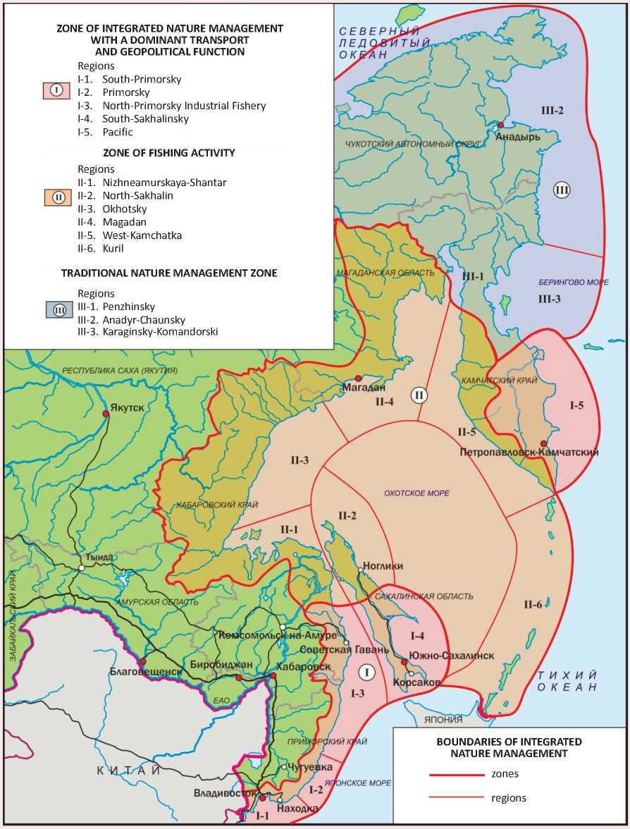
Source: Compiled by V.D. Khizhnyak using: Karkin V.P., Preobrazhensky B.V., Zharikov V.V., Stepan’ko A.A., Arzamastsev I.S., Romanov M.T. Regionalization, delimitation of coastal zones of the Russian Far East and their functional zoning In: Coastal-Marine Management: Theory, Indicators, Regional Differences . Vladivostok: Dalnauka, 2010. 308 pp. P. 220.
Figure 2. Economic zoning and development of trunk road network in the Far East of Russia
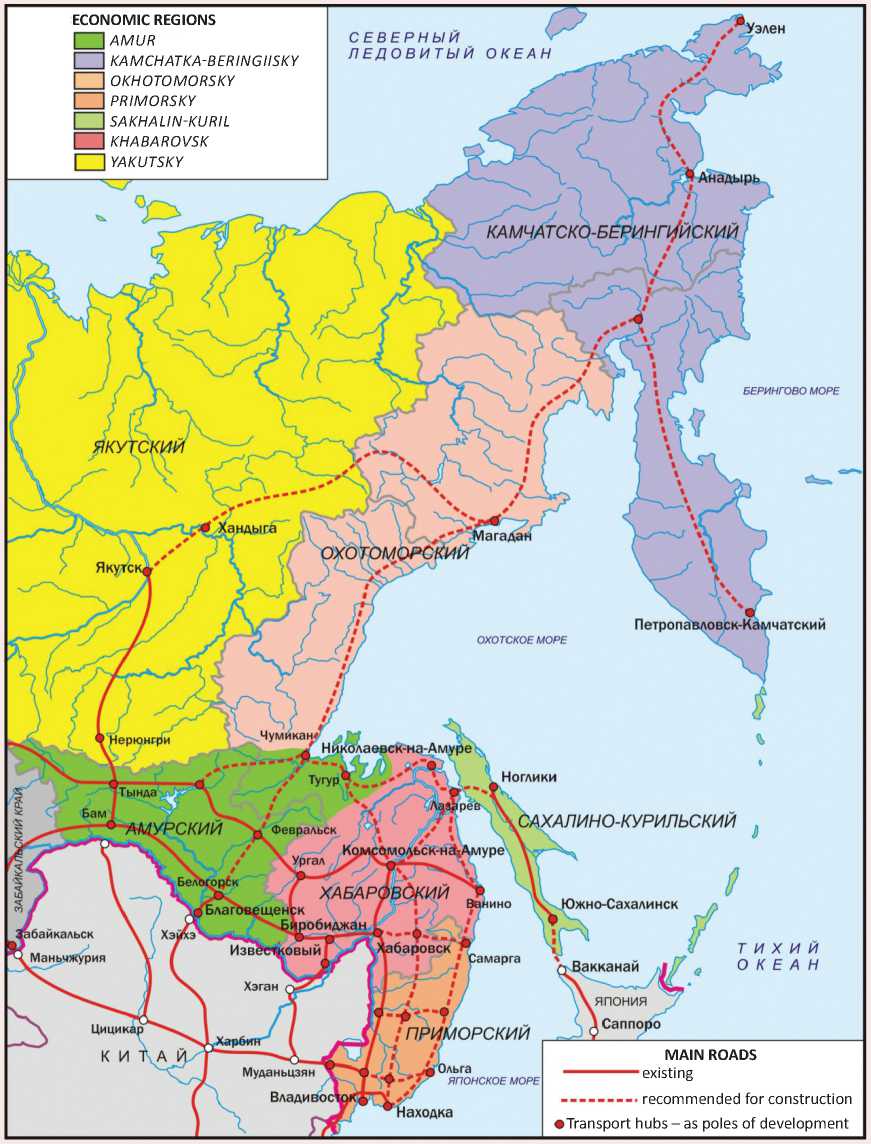
Source: Compiled by V.D. Khizhnyak using: Baklanov P.Ya., Moshkov A.V., Romanov M.T. Territorial organization of the economy in the long-term development of the Russian Far East. Proceedings of the Transbaikal State University, 2013, no. 1 (48), p. 152.
This version of the Far East zoning also could not be accepted as a baseline for the ongoing research because: a) it does not cover the entire territory of the Far Eastern Federal District; b) it is directed to the substantiation of managerial decisions on the region’s development and, accordingly, takes into account not only current but also future status of the road network; c) it takes into account the extremely limited list of parameters of the transport complex.
When assessing the potential of the Far Eastern transport system integration into the NEA transport services market, a particular interest is presented by the scheme of the economic and geographical gravitation of the constituent entities of the Russian East to the Pacific Ocean, where there are two areas within the boundaries of the Far Eastern Federal District taking into account the economic proximity to the Asia-Pacific region [32]. The first area includes the constituent entities of the Russian Federation having access to the Pacific Ocean: Kamchatka, Primorsky and Khabarovsk krais, the Magadan and Sakhalin Oblasts, Chukotka Autonomous Okrug. The second area includes the territories gravitating economically towards the Asia-Pacific region but not extending to the Pacific Ocean: the Republic of Sakha (Yakutia), the Amur Oblast and the Jewish Autonomous Region ( Fig. 3 ).
This zoning corresponds the research objectives to a certain extent, but needs further elaboration taking into account the indicators of the Far East transport complex.
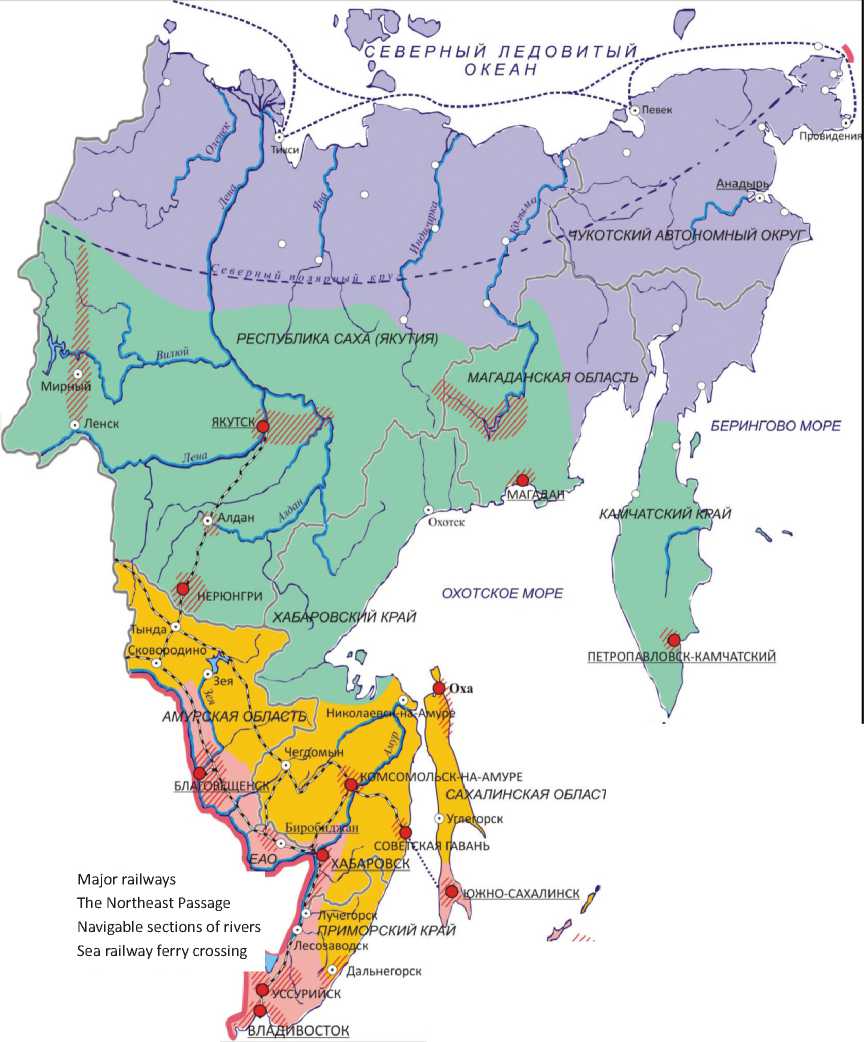
The approach proposed by the Economic Research Institute of Far Eastern Branch of the Russian Academy of Sciences is of considerable interest from the point of view of economic regionalization. In the framework of this approach the territory of the Far East is divided in terms of natural and social diversity of economic activity [33]. The approach offers a selection of four macroeconomic areas defined by a system of landscape zones and areas: the Extreme North (the Subarctic region), the Far North, the Middle North and the South (Fig. 4).
The selected macroeconomic areas allow taking into account natural factors affecting the development of the Far East transport complex and informatively justify the ongoing zoning. Therefore, when interpreting the results of cluster analysis, we will take into account the options of zoning presented in Figures 3 and 4.
The division of the Far East into smaller areas is carried out by applying the cluster analysis2. The calculations were made in the constituent entities of the Russian Federation as part of the Far Eastern Federal District (by the beginning of 2018, there were 9 entities of the Russian Federation: Republic of Sakha (Yakutia), Kamchatka Krai, Primorsky Krai, Khabarovsk Krai, Amur Oblast, Magadan Oblast, Sakhalin Oblast, Jewish Autonomous
Oblast, Chukotka Autonomous District) and municipal districts (Khabarovsk Krai). The constituent entities of the Russian Federation in the Far East, with the exception of the Khabarovsk Krai, were considered as integral units. The territory of the Khabarovsk Krai was divided into two parts during the territories’ allocation given the macroeconomic zoning (see Fig. 4): a) the Northern part, b) the Southern and Central part. The Northern part includes Ayano-Maysky, Okhotsky and Tuguro-Chumikansky municipal districts; the Southern and Central parts –Amursky, Bikinsky, Vaninsky, Verkhnebureinsky, Vyazemsky, Komsomolsky, n.a. Lazo, Nanaysky, Nikolaevsky, n.a. Polina Osipenko, Sovetsko-Gavansky, Solnechny, Ulchsky and Khabarovsk municipal districts of the region.
Figure 3. Zone of gravitation of the constituent entities of the RF in the East of Russia to the Pacific Ocean
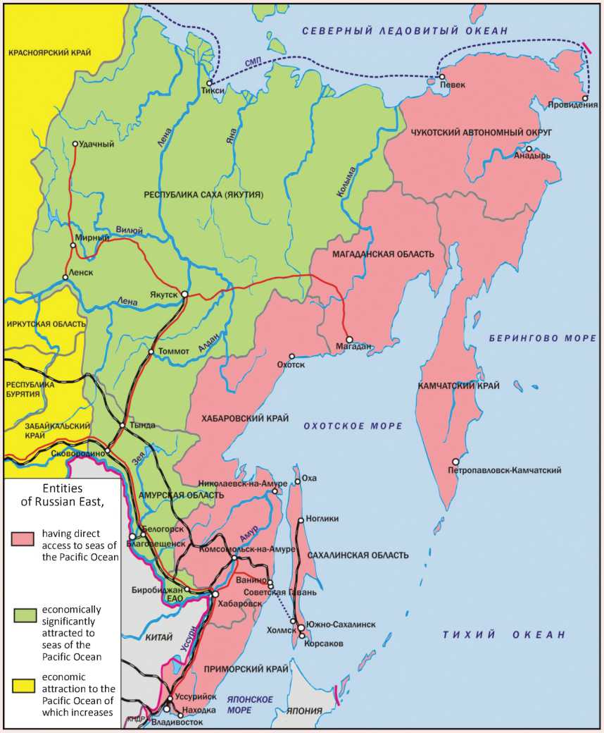
Source: Compiled by V.D. Khizhnyak using: Baklanov P.Ya., Romanov M.T. Economic-Geographical and Geopolitical Position of Pacific Russia . Vladivostok: Dalnauka, 2009. 168 pp. P. 48.
The cluster analysis is conducted on the basis of the indicators of development of transport infrastructure, transport system and the scale of foreign economic relations for 2018: railways density (km per 10 thousand km2), auto-road’s (km per 1 thousand km2), inland waterways’ density (km per 1 thousand km2), the volume of cargo transportation by railway transport3 (million tons), the volume of cargo
Figure 4. Macroeconomic areas of the Far East
TRANSPORT COMMUNICATIONS
•)Певек
>идени?
Анады^
ЧУКОТСКИЙ АВТОНОМНЫЙ ОКРУГ
ЮКАЯ ОБЛА(
МАГ/
ЯКУТС!
Ленек
БЕРИНГОВО МОРЕ
' МАГ/
ДАТСКИЙ щам
Охотск
ОХОТСКОЕ МОРЕ
:рюнгри
ЮВСКЙЙ КРАЙ
Гында юдино
ПЕТРОЛ,
■КАМЧАТСКИЙ
Никола<
HeyfoMi
Биробйд;
COBI
)ЖНО-САХАЛИНСК
Дальнегорск
I ВОСТОК
СЕВЕРНЫЙ ЛЕДОВИТЫЙ % ОКЕАН /"у
РЕСПУБЛИКА С/
Т^Лучегбрсу
Р ПРИМОРСКИЙ КР/ гЛесозаводск
Major railways
The Northeast Passage Navigable sections of rivers Sea railway ferry crossing
ЮЛЬСК*1А-АМУРЕ
I САХАЛИНСКАЯ ОБЛАСТЬ
;КАЯ ПАВАНЬ
Farthest North
SOCIO-ECONOMIC CENTERS
• Centers (cores) of areas © Local centers
AREAS OF CONCENTRATION OF ECONOMIC ACTIVITY
BORDERS
State
RF entities
Я тихий и ОКЕАН
MACROECONOMIC ZONES
Centers of municipal YAKUTSK – centers of the RF entities districts in the Far North
Source: Compiled by V.D. Khizhnyak using: Vishnevskiy D.S., Dem’yanenko A.N. Intraregional diversity. In: Pacific Russia–2030: Scenario Forecasting for Regional Development . Khabarovsk: Economic Research Institute FEB RAS, 2010. 560 p. Pp. 160-161.
transportation by road transport (million tons), cargo turnover of road transport (million t-km), export (million US dollars), import (million US dollars), the volume of exports (thousand tons), the volume of imports (thousand tons). The official data of Rosstat and the Far Eastern customs administration were used in the calculations.
Since we used the indicators of different dimensions, they were normalized according to the range of values before conducting the clustering procedure [34]:
X
X * =
Xmax where x* – normalized values of the indicator; x – the original values;
x min – the minimum value of the indicator; x max – the maximum value of the indicator.
Inclusion of export and import operations of constituent entities of the Russian Federation in the Far East into the list of the analyzed indicators modifies the previously obtained only on the basis of parameters of transport networks and evaluation of transport activity [35].
Analysis and explanation of the obtained results
According to the results of the cluster analysis on the territory of the Russian Far East the five regions have been identified ( Fig. 5 ): region I – Republic of Sakha (Yakutia), region II – Chukotka Autonomous Okrug, Kamchatka Krai, Magadan Oblast and the Northern part of Khabarovsk Krai; region III – South-Central part of Khabarovsk Krai, Amur Oblast and the Jewish Autonomous Oblast; region IV – Sakhalin Oblast; region V – Primorsky Krai. The transport characte-ristics in the context of the obtained results of the Far East Federal District regions’ clustering are shown in Tables 1, 2 and 3 .
Let us consider the specifics of the selected regions from the point of view of the characteristics of the transportation system and potential for integration into the transport market of the North East Asia.
Within region I the largest share in the transport structure is taken by the inland waterway. This region includes the territory of the Republic of Sakha (Yakutia), where much of the traffic is traditionally performed by river transport in the framework of the “Northern delivery” system4. However, in recent years, the problems of rivers shallowing and the development of surface transport infrastructure alter the structure of transport operation [36]. The most significant infrastructure changes are associated with the completion of the construction of railway Berkakit – Nizhny Bestyakh in 2014 (area was in the mode of temporary operation for freight traffic until 2018), as well as an active roads construction, for the period of 2010-2018, the length of public roads increased by 51.7%, which makes up to 30.4 thousand kilometers5. Currently the railroad in Yakutia is laid up to the Nizhny Bestyakh station, the line connects the Baikal-Amur railway with the right Bank of the Lena river (the city of Yakutsk is located on the opposite bank). 5.5 million tons of cargo had been transported by means of the exploited road section for 20186. On the territory of region I there is only one air checkpoint across the state border in the city of Yakutsk.
The allocation of Yakutia in a separate region seems reasonable. This constituent entity of the Russian Federation is geographically distant from the countries of the North East Asia and, consequently, cannot be integrated into the international transport market to the same extent that the southern Far East regions (region III, region V). However, large-scale construction of roads and railways creates the potential for the development of integration relations of the Republic of Sakha (Yakutia).
The prospects of integration of region I into the market of NEA transport services are associated with the development of land
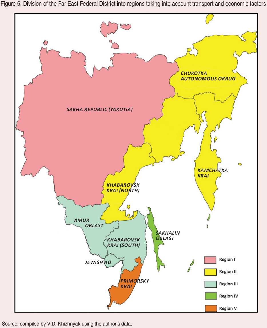
transport network and the increased use of the Northern sea route (NSR), a significant part of the Eastern section of which runs along the Northern borders of the Republic of
Sakha (Yakutia). Thus, the current integration capabilities into the market of NEA transport services for region I are low, however, there is considerable potential.
Table 1. Characteristics of the transport networks of the allocated areas
|
Region |
Length of transport networks, km |
||
|
Railways |
Roads |
Inland waterways* |
|
|
Region I |
524.5 |
30353.0 |
7734.0 |
|
Region II |
0.0 |
7601.7 |
1417.1 |
|
Region III |
5575.8 |
29512.7 |
3437.0 |
|
Region IV |
835.2 |
4987.6 |
0.0 |
|
Region V |
1558.7 |
16811.2 |
222.0 |
|
Regions |
The density of transport networks |
||
|
Railways, km per 10 thousand km2 |
Roads, km per 1 thousand km2 |
Inland waterways km on 1 thousand km2 |
|
|
Region I |
1.7 |
98.4 |
25.1 |
|
Region II |
0.0 |
36.7 |
6.8 |
|
Region III |
72.8 |
385.4 |
44.9 |
|
Region IV |
95.9 |
572.6 |
0.0 |
|
Region V |
94.6 |
1020.7 |
13.5 |
* The length of inland waterways with guaranteed dimensions of a ship course was meant.
Calculated using: Transport. Rosstat. Available at: (accessed: 10.10.2019).
Table 2. Characteristics of transport operation and foreign economic relations of the allocated regions
|
Region |
Transportation of cargo, mln t |
Cargo turnover of road transport, million ton-km |
|
|
Railway transport |
Road transport |
||
|
Region I |
13.1 |
14.3 |
1934 |
|
Region II |
0.0 |
8.8 |
595 |
|
Region III |
91.5 |
48.3 |
1315 |
|
Region IV |
2.1 |
8.8 |
362 |
|
Region V |
119.4 |
18.2 |
1130 |
Calculated using: Transport. Rosstat. Available at: (accessed: 10.10.2019).
Table 3. Characteristic of foreign economic relations of the allocated areas
|
Region |
Export |
Import |
||
|
thousand tons |
million US dollars |
thousand tons |
million US dollars |
|
|
Region I |
6202.8 |
4643.0 |
27.5 |
271.6 |
|
Region II |
4651.3 |
2384.4 |
84.6 |
248.0 |
|
Region III |
8669.6 |
2093.1 |
327.0 |
822.9 |
|
Region IV |
40396.2 |
15272.7 |
117.5 |
690.4 |
|
Region V |
6882.8 |
3439.9 |
2106.8 |
4131.8 |
Calculated using: Transport. Rosstat. Available at: (accessed: 10.10.2019).
For region II a key mode of transport is waterway, used mainly for the organization of intraregional transportation. Maritime transport serves for cabotage and coastal passenger transportation. River transport is used in the organization of the “Northern delivery”.
Region II includes the territories of the Russian Far East which are the least provided with land transportation networks: Kamchatka Kray, northern part of Khabarovsk Krai, Magadan Oblast and Chukotka Autonomous
Okrug. In these constituent entities of the Russian Federation (territories) there are no railways, the density of roads with hard surface is very low – 2.7 km on 1 thousand km2. In the absence of year-round roads, and given the harsh climatic conditions the winter roads are widely used7.
Although region II includes nine operating checkpoints across the state border of the Russian Federation, they do not have a significant influence on the integration potential, because the five of them operate on an irregular or seasonal basis. Only the checkpoints in seaports of Magadan, Okhotsk, and Petropavlovsk-Kamchatsky, and the air crossing point of Petropavlovsk-Kamchatsky are constantly operating.
The integration potential of the transport system of region II from the point of view of possibility of participation in the transport market of the North East Asia is expected to increase significantly when intensifying the traffic along the NSR. In this case, the ports of the constituent entities of the Russian Federation included into region II can become reference points in the organization of the movement along the NSR and will be used for communication centers allocation as intermediate and repair bases, the points of rescue units of the Ministry of Emergency Situations of Russia, etc.
Region III represents the areas having the most diversified transport infrastructure, including in the framework of cross-border interactions with the Asian region. Region III includes Amur Oblast, Jewish Autonomous Oblast and the central and southern parts of Khabarovsk Krai, i.e. territories having a developed land transportation network. The transport of this region performs transit and contact functions. The transit function means that latitudinal trunk roads and railways run through the region’s territories: the TransSiberian and the Baikal-Amur Railways, Federal highway “Amur”, through which the transportation of goods from Eastern Siberia to the markets of APR countries is performed. The contact function implies that owing to the edge position of these constituent entities of the Russian Federation transport is intended to serve external economic ties. This is facilitated by the presence of sections of the state border with China (along the river) in region III. To implement the contact function within the boundaries of region III there are 14 checkpoints across the state border, including five within the Amur Oblast, two in the Jewish Autonomous Oblast and eight in the central and southern parts of the Khabarovsk Krai. Half of them (7 points) are mixed cargo and passenger checkpoints, transporting by river in summer and by cars on ice in winter.
The integration potential of region III will increase in the future with the completion of transport infrastructure of international cooperation: the railway (Jewish Autonomous Oblast) and automotive (Amur Oblast) bridges between Russia and China, the completion of which is planned in 2020/ Thus the integration potential of region III in the transport market of the North East Asia is significant, however, the integration is likely to be limited to the cooperation with China.
The allocation of the Sakhalin Oblast into a separate region IV in the context of the division is explained by a combination of a poorly developed transport system and a significant amount of foreign economic relations (export, 89% of value export8 are made up by crude oil and LNG). There are six checkpoints across the state border, including five marine ones in region IV.
The increase of the integration potential of region IV is related to the implementation of projects on transport infrastructure development. Indeed, the ongoing reconstruction of the railway network on Sakhalin island, which began in 2003 (project completion in 2020), in conjunction with the program of development of sea ports, airports and the prospective construction of a transport crossing to the mainland (bridge, dam or tunnel through the Nevelski strait), will greatly enhance the capability of the transport system of region IV in cooperation with the countries of the North East Asia. Assuming positive externalities in the longer term, the implementation of transport connection of Sakhalin Island with the Islands of the Japanese archipelago is possible.
Region V includes the territory of Primorsky Krai. The territory is highly diversified by the type of transport, it has an extensive network of railways and roads, there are large transport hubs of regional and national significance. Having certain similarities with region III by the level of development of transport infrastructure, it has a high degree of implementation of integration potential currently available.
Geographically this region is the area of the outlet of the Trans-Siberian railway and a number of Federal roads to the sea ports of the Pacific coast: these are Vladivostok, Nakhodka, Vostochny. By the end of 2018 the ports of Primorsky Krai accounted for 70% of the total volume of transportation by sea9 in the Far Eastern Federal District. There are six checkpoints across the state border of the Russian Federation in the ports.
There are 15 checkpoints across the state border in region V, including three railway border checkpoints of the Russian Federation with China and the DPRK: 1) Grodekovo (RF) – Suifenhe (PRC); 2) Makhalino (RF) – Hunchun (PRC); 3) Hasan (RF) – Tumangan (DPRK) and five car border checkpoints.
Transport infrastructure of region V continues to evolve. Having relatively high current level, the prospects of integration of region I into the transport complex of NEA are high. There is integration potential is the development of traffic via ITC “Primorye-1” and “Primorye-2” using road, rail and sea modes of transport.
Dispute about the results
The conducted research extends the ideas about the future scope of international transport cooperation as a condition of general economic integration in the area of the North-East Asia, and complements the analytical framework for the comparative analysis of the options of design of the international transport system in this region of the world.
The proposed zoning of the Far East is based on the attempt of taking into account the level of transport infrastructure development and the scale of foreign economic interaction of the constituent entities of the Russian Federation as part of the Far East Federal District with the countries of the North-East Asia. The obtained results allow us to assess the current capabilities of integration of the transport system of the Far East into the international transport market. The five regions allocated according to the results of cluster analysis differ in both the level of transport network development, and the scale of transport activity and foreign economic relations.
The presented zoning allows us to approach the management of integration of the Far East and the North-East Asia interactions differentially and could serve as a basis for the formation of a targeted incentive policy of the state [37].
Certainly, the research results can be refined in the future. There are two possible directions of the research development. First, a more accurate division not tied to the constituent entities of the Russian Federation may be done in case we having more detailed information on the characteristics of the Eastern regions’ transport system (e.g. in the context of municipalities). Second, the future research may be conducted taking into account not only the current performance but also the ongoing/ planned projects of development of transport system in Russia’s Eastern regions. This will allow to understand the strategic vision for integration better.
References The potential for integration of the transport complex of the east of Russia into the international market of transport services
- Balassa B. The Тheory of Economic Integration. Homewood, Ill.: R.D. Irwin, 1961. 324 p.
- Balassa В. Trade creation and trade diversion in the european common market. The Economic Journal, vol. 77, 1967, pp. 1-21. DOI: 10.2307/2229344
- Viner J. The Customs Union Issue. New York: Carnegie Endowment for International Peace, 1950. Pp. 41-55.
- Heinrichs H., Jochem P., Fichtner W. Including road transport in the EU ETS (European Emissions Trading System): A model-based analysis of the German electricity and transport sector. Energy, 2014, vol. 69, pp. 708-720. Available at: DOI: 10.1016/j.energy.2014.03.061
- Siskos P., Zazias G., Petropoulos A., Evangelopoulou S., Capros P. Implications of delaying transport decarbonisation in the EU: A systems analysis using the PRIMES model. Energy Policy, 2018, vol. 121, pp. 48-60. Available at: DOI: 10.1016/j.enpol.2018.06.016
- Sajid M.J., Cao Q., Kang W. Transport sector carbon linkages of EU's top seven emitters. Transport Policy, 2019, vol. 80, pp. 24-38. Available at:
- DOI: 10.1016/j.tranpol.2019.05.002
- Medeiros T. Cross-border transports and cross-border mobility in EU border regions. Case Studies on Transport Policy, 2019, vol. 7, no. 1, pp. 1-12. Available at:
- DOI: 10.1016/j.cstp.2018.11.001
- Oberg M., Nilsson K.L., Johansson C. Major transport corridors: the concept of sustainability in EU documents. Transportation Research Procedia, 2017, vol. 25, pp. 3694-3702. Available at:
- DOI: 10.1016/j.trpro.2017.05.339
- Cavallaro F., Dianin A. Cross-border commuting in Central Europe: features, trends and policies. Transport Policy, 2019, vol. 78, pp. 86-104. Available at:
- DOI: 10.1016/j.tranpol.2019.04.008
- Sultanov T., Suleimenov T., Tlepiyeva G., Sansyzbajeva Z. Development of transit potential in conditions of integration of the Republic of Kazakhstan into the world transport system. Procedia Computer Science, 2019, vol. 149, pp. 430-435. Available at:
- DOI: 10.1016/j.procs.2019.01.158
- Tsvetkov V.A., Zoidov K.Kh., Medkov A.A., Chernyshov M.M. Formirovanie global'noi Evrazii: problemy sopryazheniya tranzitnykh system [Formation of global Eurasia: problems of interfacing transit systems]. Мoscow: FGBUN Institut problem rynka RAN, 2018. 131 p.
- Larin O.N. Prospects for integration of transport systems of the Eurasian economic Union. Problemy natsional'noi strategii=National Strategy Issues, 2017, no. 4(43), pp. 152-170. (In Russian).
- Ha H.-K., Oh J.E. (Eds.). Building an Integrated Transport Market for China, Japan, and Korea: Building a Regional Coordinating Institution. Sejong: Korea Transport Institute, 2003. 245 p. Available at: https://english.koti.re.kr/user/bbs/BD_selectBbs.do?q_bbsCode=1017&q_bbscttSn=2012051900000070602&q_clCode=6&q_lang=eng
- Chia S.Y. ASEAN economic integration and physical connectivity. Asian Economic Papers, 2019, vol. 15, no. 2, pp. 198-215.
- DOI: 10.1162/ASEP_a_00438
- Kim T.-S., Breazeale K. (Eds.). A Design for Northeast Asian Transport Market Integration - The Cases of ASEAN and NAFTA. Sejong: Korea Transport Institute, 2004. 226 p. Available at: https://english.koti.re.kr/ user/bbs/BD_selectBbs.do?q_bbsCode=1017&q_bbscttSn=20161121152201318&q_clCode=6&q_lwprtClCode=-1&q_lang=eng
- Adler N., Fu X., Oum T.H., Yu C. Air transport liberalization and airport slot allocation: the case of the Northeast Asian transport market. Transportation Research Part A, 2014, vol. 62, pp. 3-19. Available at: https://
- DOI: 10.1016/j.tra.2014.02.003
- Kim S., Yoon Y. On node criticality of the Northeast Asian air route network. Journal of Air Transport Management, 2019, vol. 80, 101693. Available at:
- DOI: 10.1016/j.jairtraman.2019.101693
- Chung T., Han J. Evaluating competitiveness of transshipment cargo in major airports in Northeast Asia: airport branding. The Asian Journal of Shipping and Logistics, 2013, vol. 29, no. 3, pp. 377-394. Available at:
- DOI: 10.1016/j.ajsl.2013.12.005
- Zhang Y., Zheng X., Lu W. Measuring the openness of Chinese international air transport policy. transport policy, 2018, vol. 72, pp. 208-217. Available at:
- DOI: 10.1016/j.tranpol.2018.03.014
- Yang Y.-C., Chen S.-L. Determinants of global logistics hub ports: comparison of the port development policies of Taiwan, Korea, and Japan. Transport Policy, 2016, vol. 45, pp. 179-189. Available at:
- DOI: 10.1016/j.tranpol.2015.10.005
- Shinohara М., Saika T. Port governance and cooperation: the case of Japan. Research in Transportation Business & Management, 2018, vol. 26, pp. 56-66. Available at:
- DOI: 10.1016/j.rtbm.2018.02.009
- Huo W., Zhang W.,Chen P. S.-L. Recent development of Chinese port cooperation strategies. Research in Transportation Business & Management, 2018, vol. 26, pp. 67-66. Available at:
- DOI: 10.1016/j.rtbm.2018.01.002
- Wu S., Yang Z. Analysis of the case of port co-operation and integration in Liaoning (China). Research in Transportation Business & Management, 2018, vol. 26, pp. 18-25. Available at:
- DOI: 10.1016/j.rtbm.2018.02.007
- Planovo-ekonomicheskii atlas Dal'nevostochnogo ekonomicheskogo raiona. Vyp. 2. Obshchaya kharakteristika razvitiya i razmeshcheniya proizvoditel'nykh sil [The planning and economic atlas of the Far Eastern Economic region. Vol. 2. General characteristics of the development and deployment of productive forces]. Khabarovsk: IEI DVO RAN, 1989. 33 p.
- Ekonomicheskaya politika: regional'noe izmerenie [Economic policy: a regional dimension.]. Vladivostok: Dal'nauka, 2001. 224 p.
- Romanov M.T. Territorial'noe ustroistvo khozyaistva i naseleniya na rossiiskom Dal'nem Vostoke [Territorial structure of the economy and population in the Russian Far East]. Vladivostok: Dal'nauka, 2004. 232 p.
- Tikhookeanskaya Rossiya - 2030: stsenarnoe prognozirovanie regional'nogo razvitiya [Pacific Russia-2030: scenario forecasting of regional development]. Khabarovsk: IEI DVO RAN, 2010. 560 p.
- Minakir P.A. Issledovaniya ekonomiki Dal'nego Vostoka. 1975-2000 [Studies of the economy of the Far East. 1975-2000]. Khabarovsk: IEI DVO RAN, 2017. 912 p.
- Baklanov P.Ya., Karakin V.P., Sheingauz A.S. Nature management of the Russian Far East and adjacent territories. Prostranstvennaya ekonomika=Spatial Economics, 2005, no. 1, pp. 27-45. (In Russian).
- Karakin V.P., Preobrazhenskii B.V., Zharikov V.V., Stepan'ko A.A., Arzamastsev I.S., Romanov M.T. Zoning, delimitation of coastal zones of the Russian Far East and their functional zoning. In: Pribrezhno-morskoe prirodopol'zovanie: teoriya, indikatory, regional'nye osobennosti [Coastal and marine nature management: theory, indicators, regional features]. Vladivostok: Dal'nauka, 2010. 308 p. (In Russian).
- Baklanov P.Ya., Moshkov A.V., Romanov M.T. Territorial organization of the economy in the long-term development of the Russian Far East. Uchenye Zapiski Zabaikalskogo Gosudarstvennogo Universiteta=Scholarly Notes of Transbaikal State University, 2013, no. 1 (48), pp. 143-155. (In Russian).
- Baklanov P.Ya., Romanov M.T. Ekonomiko-geograficheskoe i geopoliticheskoe polozhenie Tikhookeanskoi Rossii [Economic-geographical and geopolitical position of Pacific Russia]. Vladivostok: Dal'nauka, 2009. 168 p.
- Vishnevskii D.S., Dem'yanenko A.N. Intraregional diversity. In: Tikhookeanskaya Rossiya - 2030: stsenarnoe prognozirovanie regional'nogo razvitiya [Pacific Russia-2030: scenario forecasting of regional development]. Khabarovsk: IEI DVO RAN, 2010. 560 p. (In Russian).
- Mirkin B.G. Metody klaster-analiza dlya podderzhki prinyatiya reshenii: obzor: preprint [Cluster analysis methods for decision-making support: review: preprint.]. Мoscow: NIU HSE, 2011. 88 p.
- Bardal' A.B. Transportnyi kompleks Dal'nego Vostoka: transformatsiya i integratsiya [Transport complex of the Far East: transformation and integration]. Khabarovsk: IEI DVO RAN, 2019. 336 p.
- Egorova T.P., Delakhova A.M. Methodological tools for a comprehensive assessment of transport security of local economic systems in the regions of the North. Trendy i upravlenie=Trends and Management, 2018, no. 1, pp. 14-28. 10.7256/2454-0730.2018.1.24926. (In Russian).
- DOI: 10.7256/2454-0730.2018.1.24926.(InRussian)
- Minakir P. A., Prokapalo O. M. Far Eastern priority: investment and institutional combinations. Zhurnal Novoi ekonomicheskoi assotsiatsii=The Journal of the New Economic Association, 2018, no. 2(38), pp. 146-155. (In Russian).
