The use of remote sensing, geophysical methods and soil analysis in the study of sites disturbed by agricultural activity

Author: Zhurbin I.V., Nazmutdinova A.I., Milich V.N., Petrov R.P., Ivanova M.G., Knyazeva L.F., Borisov A.V., Modin R.N., Vorobieva N.G., Zinchuk S.V.
Journal: Archaeology, Ethnology & Anthropology of Eurasia @journal-aeae-en
Section: The metal ages and medieval period
Article in issue: 2 т.47, 2019.
Free access
Short address: https://sciup.org/145145419
IDR: 145145419 | DOI: 10.17746/1563-0110.2019.47.2.103-111
Text of the review article The use of remote sensing, geophysical methods and soil analysis in the study of sites disturbed by agricultural activity
Intensive farming in the second half of the 20th century resulted in destruction of large number of archaeological sites across contemporary Russia. Plowing flattens terrain features of settlements (ramparts, ditches, foundation pits, etc.), intensifies erosional processes, and contributes to displacement and eventual obliteration of cultural layers. Such destruction commonly impacts medieval sites of the Polom (late 5th to early 9th centuries) and Cheptsa (late 9th to early 13th centuries) cultures located in the Cheptsa River basin in western Russia, where more than one hundred such sites exists (Ivanov et al., 2004: 53–55). Research in the region has shown that settlements destroyed by plowing can be subdivided into several zones: those with a superficially disrupted cultural layer, whose lower part is preserved in situ; those where cultural layer has been completely replaced so that only bottom parts of structures are preserved, partly overlaid by a thin cultural lens; and those of the “household periphery”, where neither cultural layer nor structures are visible, but the plow layer and the one underlying it nonetheless contain artifacts. Two first zones delimit the area of settlement, while the adjoining “household periphery” marks the boundaries of the archaeological site in terms of historical and cultural heritage preservation. Interdisciplinary studies of Kushmanskoye III—a medieval Finno-Ugric settlement in the Yarsky District, Udmurt Republic, shows the successful application of this scheme in tracing settlement location in agricultural zones.
Preliminary archaeological investigations
Kushmanskoye III was discovered by G.T. Kondratiyeva in 1959 (Ibid.: 202–203). The absence of terrain features, and its proximity to a large medieval fortified settlement at Uchkakar suggested that the site was an unfortified village. In 2012, a test pit measuring 1 × 1 m was made in the site’s center (Fig. 1). The pit revealed a cultural layer up to 0.7 m thick, containing artifacts of the 9th–12th centuries AD. Its upper portion was destroyed by many years of plowing, while its lower part remained intact (Kirillov, 2013: 45–47, fig. 88–96). This settlement was attributed to the Kushmanskoye complex of sites, which includes the fortified settlement of Uchkakar, three unfortified settlements, and a burial ground (Ivanova, Kirillov, 2012). On the basis of landscape features, the spatial extent of the site was tentatively assessed (Fig. 1).
Aerial photography from unmanned vehicles
Remote sensing methods can significantly aid the search for archaeological sites (Borisov, Korobov, 2013: 52–58; Garbuzov, 2003; Zhukovsky, 2010). Under optimum flying altitude and weather conditions, unmanned aerial vehicles or drones allow task-oriented aerial photography of specific areas.
We conducted aerial photography to assess the Cheptsa culture area, totaling over 70 km2, orthophotographic mapping, and digital modeling of landscape and relief using the MSK-18 coordinate system (Vorobieva, Zhurbin, Knyazeva, 2016). The orthophotomap was then correlated with data obtained through thermal and multispectral imaging.
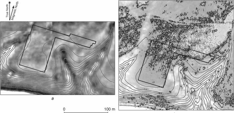
Thermal imaging survey records land surface temperature distribution, which reflects the thickness of the overlying humic soil layer. To process the images we employed a Gaussian filter, piecewise linear transformation, background subtraction, and band-pass filtering (Fig. 2, a ). Sections of the replaced cultural layer appear as high-contrast (light areas of the image) in the promontory part of the settlement, while remains of the superficially disrupted cultural layer are most visible in its central part (dark areas). Differences between these zones are otherwise untraceable in terms of surficial terrain or vegetation.
Multispectral imaging allows us to receive similar information on the basis of phyto-indication. We classified vegetation areas on the basis of Shannon-Kotelnikov wavelet data. Features were based on average values and standard deviations calculated from a 2D discrete wavelet-transformation (Nazmutdinova, Milich, 2016). Areas of the superficially disrupted cultural layer correspond to higher values of characteristic features, such as compact contours of images with local phyto-indication attributes (Fig. 2, b ). Comparison with geophysical data corroborates this observation (Nazmutdinova, Milich, Zhurbin, 2017). We found good agreement between the results of thermal imaging survey and multispectral imaging with regard to location of thick areas of organic-rich soil.
Complex geophysical and soil studies
Aerial photography shows contrasting areas of a thick humic layer that could reflect either natural soil accumulation in negative relief forms or human activities (cultural layer). Pairing our analysis with geophysical methods decreases ambiguities in the interpretation of this aerial photographic
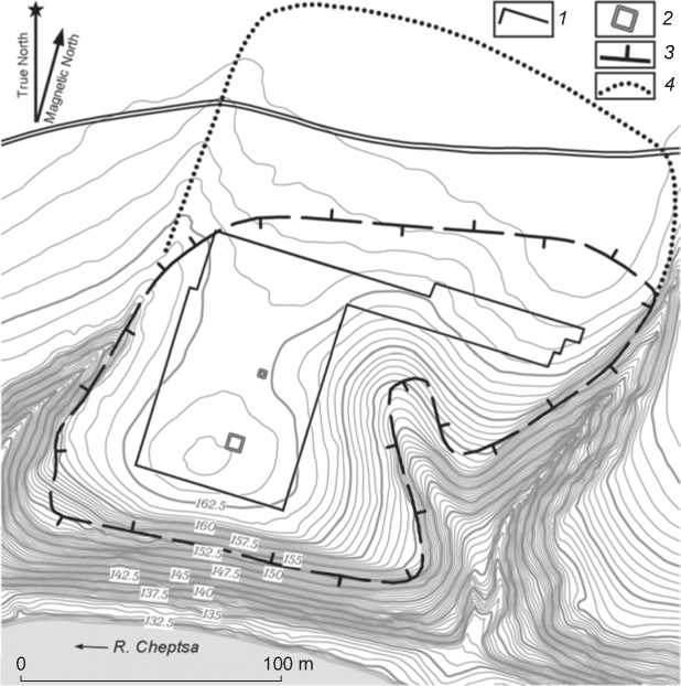
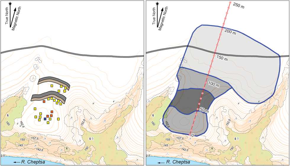
Fig. 1 . Topographic plan of Kushmanskoye III (based on the plan by LTD “Finko”, corrected and supplemented by R.P. Petrov). Contour interval is 0.5 m; the system of elevations is conventional.
1 – boundaries of the resistivity survey area; 2 – test pit and excavation; 3 – boundaries of the settlement after (Kirillov, 2013: Fig. 84); 4 – boundaries of the settlement according to the results of multimethodological investigations.
b
Fig. 2. Maps showing the thickness of humic layer according to thermal imaging survey ( a ), and areas with characteristic features according to multispectral imaging ( b ), with indicated area of resistivity survey.
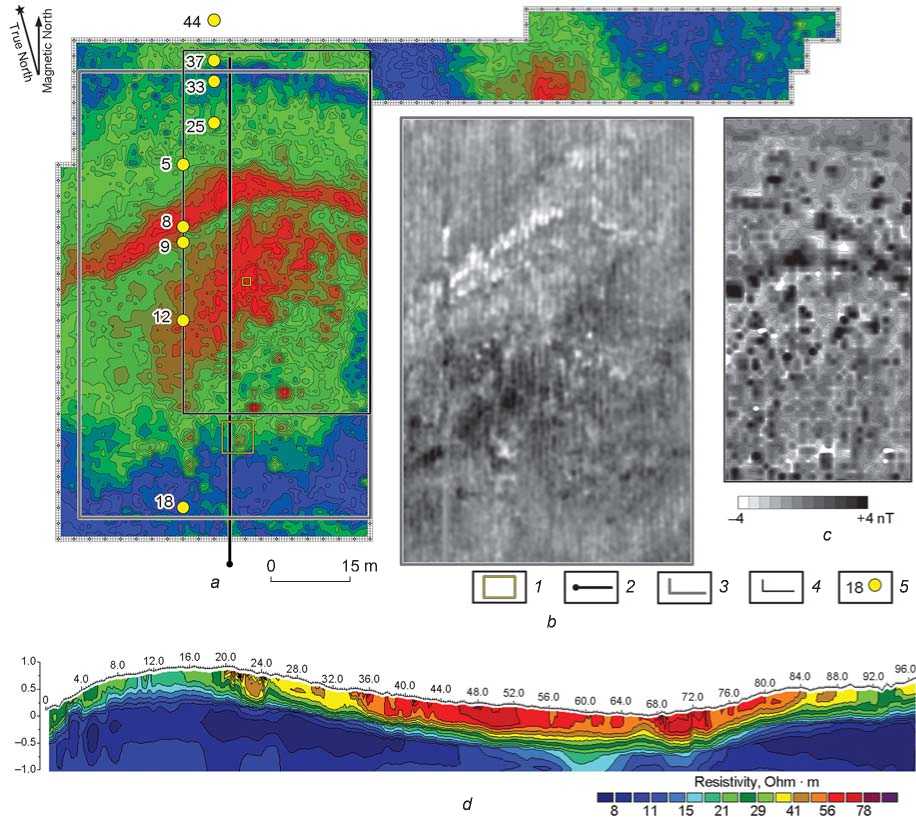
Fig. 3. Results of geophysical studies.
a – resistivity survey; b – ground penetrating radar (calculated depth, 0.77 m); c – magnetogram; d – geoelectric section.
1 – test pit and excavation; 2 – electrical resistivity tomography profile; 3 – boundary of the ground penetrating radar survey; 4 – boundary of the magnetometry survey; 5 – soil drilling.
data. Specifically, the integration of geophysical methods (resistivity and magnetometry surveys, ground penetrating radar, etc.) is often required when geological background is heterogeneous or noise/ interference is high (Geophysical Survey…, 2008: 13–18; Lockyear, Shlasko, 2017; Mozzi et al., 2016). At Kushmanskoye III, we conducted geophysical investigations across the whole area suspected of yielding archaeological features*. On the basis of this work, we identified two lines of defensive constructions, previously invisible on the terrain surface, and assessed differences in the thickness of cultural deposits across the site.
Defensive constructions appear to delineate the boundary and physical structure of the settlement. Resistivity survey revealed a ditch serving as an inner fortification line, represented by an arc-shaped high resistivity zone traversing the site area from west to east (Fig. 3, a). Ground penetrating radar (Fig. 3, b) and magnetometry (Fig. 3, c) surveys, and electrical resistivity tomography (range of 68– 74 m in Fig. 3, d) corroborated inferences of the presence of a ditch. Results of geophysical surveys agree with data obtained through soil analysis (Fig. 4, core 8)*. The ditch in the outer fortification line is less pronounced. It appears in the data as an arc-shaped high resistivity zone “connecting” mouths of ravines (Fig. 3, a; Fig. 4, core 37). Ramparts appear in the geophysical survey as elongated areas with rather stable physical parameters. The base of the inner rampart is located across the 64–68 m range, while that of the outer rampart is within 90–96 m (Fig. 3, d). Soil cores also corroborate the presence of the ramparts (see Fig. 4, cores 9 and 33).
The fortifications are thus located between ravines that delimit the territory of the settlement from west and east. Such an arrangement of fortifications is typical of fortified settlements associated with the Cheptsa culture and located on promontories. Characteristic features include the incorporation of natural landscape boundaries and the construction of fortifications on gradual slopes along the settlement’s unprotected side (Ivanova, 1998: 214–225; Ivanova, Zhurbin, 2015). At present, fortifications of Kushmanskoye III appear to have been near-completely obliterated through plow activity.
Data obtained through geophysical, soil, and archaeological investigations made it possible to reconstruct the layout of the settlement (Fig. 5, a ). Excavation in the zone of the replaced cultural layer (Fig. 3, a ) revealed lower portions of three noncontemporaneous constructions (Ivanova, 2016: 51–63). The archaeological assemblage recovered from this area is typical of medieval Finno-Ugric sites of the early 2nd millennium AD.
Resistivity and ground penetrating radar surveys also clearly show areas of superficially disrupted and fully replaced cultural layers. The configuration of the high resistivity zones coincides almost perfectly with corresponding sectors in thermal and multispectral images (cf. Fig. 2 and 3, a ). Data from electrical resistivity tomography also support these observations (Fig. 3, d ), showing a thick and organic-rich layer at across the range 34–84 m. On this matter, geophysical data also agree with the results of soil drilling. The cultural layer is nearly absent in the highest elevation portion of the site, where a plowed layer overlies bedrock (see Fig. 4, core 18). Then follows a section of well-preserved cultural layer composed of gray loam with charcoal, fragments of burnt clay, and artifacts (see Fig. 4, core 12). The original test pit that confirmed the presence of the settlement is located within this deposit (see above). This deposit extends up to the inner fortification line. North of it,
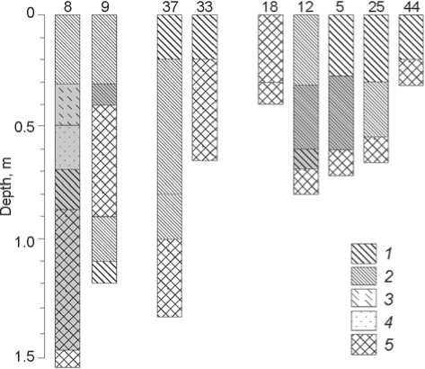
Fig. 4. Lithologic structure of the cores.
1 – heavy loam; 2 – light loam; 3 – sandy loam; 4 – sand; 5 – subsoil clay. Shading points to the presence of archaeological remains (ceramics, bones, etc.).
the thickness of the cultural layer diminishes to 0.3– 0.4 m (see Fig. 4, core 5). However, magnetometry survey recorded several anomalies in this part of the settlement (Fig. 3, c ). Presumably these are associated with traces of ground-based constructions annihilated by plowing. It is possible that the boundary between zones of the superficially disrupted and replaced cultural layer occurs near the location of this soil core, as no archaeological remains were found in cores taken in front of the inner fortification line (see Fig. 4, core 25). This pattern is also visible in the thermal image, but it is indistinct in the multispectral image and barely traceable in geophysical data. Outside the outer fortification line, the plowed layer overlies subsoil clay (see Fig. 4, core 44). Thus, the comparative analysis of several lines of parallel data demonstrates the presence of the cultural layers and helps to define their borders at the site.
Geochemical and microbiological studies
In order to assess the extent of the cultural layer outside the settlement, soil samples from plow and subplow horizons were taken every 10 m in catena across the site and adjacent areas (see Fig. 5, b ). We estimated magnetic susceptibility, content of phosphates, and viable microbial biomass (Fig. 6). High concentration of phosphates serves as an integral indicator of anthropogenic impact, while magnetic susceptibility can reveal accumulations of pyrogenic matter in the
И212Го!3 ГВ~| 4I ® I5 □678 0 100 m аb
Fig. 5. Layout of the settlement ( a ), and areas with various degrees of disruption of the cultural layer ( b ), according to the data of interdisciplinary studies.
1 – defensive constructions; 2–4 – features revealed through geophysical investigations, including 2 – confirmed by excavations, 3 – confirmed by soil drilling; 5 – soil drilling; 6 – area of the superficially disrupted cultural layer; 7 – area of the fully replaced cultural layer;
8 – “household periphery”.
soil. Finally, viable microbial biomass can point to the influx of anthropogenic organic substances into the soil. In our analysis, the content of phosphorus was determined by extraction of 2N HCl, while magnetic susceptibility was evaluated by means of kappameter KT-5, and viable microbial biomass was estimated using the substrate-induced respiration method (Anderson, Domsch, 1978).
The boundaries of the areas with high phosphate content in the plow layer correspond precisely to the boundaries of the settlement established by aerial and geophysical data. High phosphate content is also observed outside the outer fortification line. It is possible that during the Middle Ages, human activities proceeded far beyond the boundaries determined by fortifications (see Fig. 5, a ) and landscape features (see Fig. 1).
Analysis of microbial biomass in the plow layer, particularly within the subplow layer, also led to the same conclusion. Areas with high biomass concentration were recorded outside the defensive constructions. High values of microbial biomass in the subplow layer in some units far from the site suggest an influx of large amounts of organic matters into the soil (Chernysheva et al., 2014).
A concomitant increase in the amount of phosphates and in magnetic susceptibility clearly points to the presence of the cultural layer and an anthropogenic soil change far from defensive constructions in the subplow layer across the 170–190 m range. In this lower, undisturbed area of the soil, it is likely that original anthropogenic soils are still preserved. We suggest to term this area “household periphery” of the settlement (see Fig. 5, b ), and to attribute it to the object of historical and cultural heritage (see Fig. 1).
Significance of multimethodological investigations
Areas where the cultural layer is only superficially disrupted are best revealed by thermal and multispectral images (see Table ). The “warmest” zones and areas displaying phyto-indication features with an
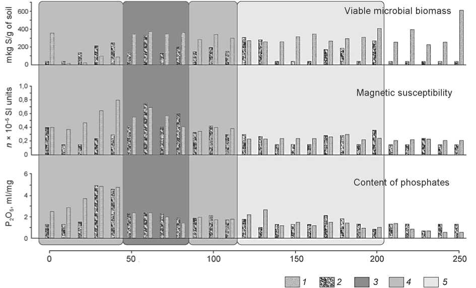
Fig. 6. Chemical and microbiological properties of the plow and subplow layers.
1 – plow layer; 2 – subplow layer; 3 – area of the superficially disrupted cultural layer; 4 – area of the replaced cultural layer; 5 – “household periphery”.
The informative potential of various science-based methods for assessing the structure of archaeological sites
|
Methods |
Zones |
||
|
superficially disrupted cultural layer |
replaced cultural layer |
“household periphery” |
|
|
Aerial photography in the visible range |
± |
± |
– |
|
Thermal imaging survey |
+ |
+ |
± |
|
Multispectral imaging |
+ |
+ |
– |
|
Resistivity survey |
+ |
+ |
– |
|
Magnetometry survey |
+ |
+ |
± |
|
Ground penetrating radar |
+ |
± |
– |
|
Electrical resistivity tomography |
+ |
+ |
– |
|
Analyses of grain size distribution and morphological properties of soil |
+ |
+ |
– |
|
Geochemical and microbiological soil analyses |
+ |
+ |
+ |
Note: “+” denotes a nearly universal efficiency; “±” efficiency in combination with other methods; “–” efficiency under certain conditions only.
inhomogeneous structure correspond to the thick organic-rich layer. This approach can distinguish clearly between zones of the superficially disrupted and fully replaced cultural layer, but fails to indicate the “household periphery” in a distinct way (see
Fig. 2). The application of geophysical methods allows us to outline the region more accurately. A well-preserved cultural layer is traceable as a structurally heterogeneous zone with higher values of physical parameters (Fig. 3). Morphological and chemical properties of soils in the zones of geophysical anomalies provide help to differentiate the contribution of the site layout from that of ground composition (Fig. 4), while electrical resistivity tomography reveals both physical parameters of archaeological features and the boundaries of superficially disrupted and replaced zones in the cultural layer (see Fig. 3, d). These data supplement significantly the information received before.
Data obtained through thermal imaging survey and multispectral imaging are also useful for identification of replaced areas in the cultural layer. The “coldest” zones and areas showing no distinct local phytoindication properties correspond to areas of thin organic cover. Using contrast changes in these thermal and multispectral images, the boundary between superficially disrupted and replaced zones of the cultural layer in the promontory part of the settlement can be accurately defined (Fig. 2). Resistivity and magnetometry surveys show this boundary as a field with a relatively uniform structure, while local anomalies are associated with layout features (see Fig. 3, a , c ). Electrical resistivity tomography (Fig. 3, d ) combined with soil analyses (Fig. 4) makes it possible to determine the source of geophysical anomaly (properties of parental rocks or anthropogenic impact) and enables us to assess the preservation of cultural horizons.
The “household periphery” can be reliably identified only with the aid of geochemical methods and microbiological soil analysis (see Fig. 5, b ; 6). However, an indirect indicator of such an area may be heterogeneous patterning on the thermal image, correlating with irregular geophysical anomalies, which together indicate accumulations of pyrogenically transformed soil and subsoil, caused by plowing and erosion.
Conclusions
Comparative analysis of data received through aerial photography, geophysical studies, soil analysis (grain size distribution, morphological, geochemical, and microbiological properties of soils), and archaeological excavations, enable us to establish the layout of Kushmanskoye III. We successfully delineated areas with various degrees of disruption of the original cultural deposit, documenting the site’s broader extent for the purposes of historical and cultural heritage preservation. In sites that have been significantly disturbed through agricultural activity, individual methods are only indirectly informative with regard to the preservation and structure of the cultural layer. The collation of various data makes the information about the archaeological sites more and more accurate, and the reconstruction thereby becomes more and more reliable.
Acknowledgement
This study was supported by the Russian Foundation for Basic Research (Project No. 18-49-180007 p-a).
