Wells as a source of cultural and chronological information: the case of Kamennyi Ambar, southern Trans-Urals

Author: Epimakhov A.V., Panteleeva S.E., Koryakova L.N.
Journal: Archaeology, Ethnology & Anthropology of Eurasia @journal-aeae-en
Section: The metal ages and medieval period
Article in issue: 4 т.48, 2020.
Free access
This article presents 44 radiocarbon dates from 18 water wells of different Bronze Age periods at Kamennyi Ambar settlement, in the southern Trans-Urals. At the preliminary stage, statistical outliers were identifi ed, which enhanced the reliability of the conclusions. Potsherds from the fi lling of the wells, contextual analysis of dating samples, and 14C dates allowed us to carry out the cultural attribution of nearly all wells (31 out of 34). The analyzed wells were subdivided into four chronostratigraphic groups corresponding to various settlement phases. Their duration and chronological limits were estimated. Most wells were found to belong to the Sintashta-Petrovka period (densely spaced linearly arranged blocks of structures inside fortifi ed areas). This period comprised three construction phases, the latest of which correlates with the Petrovka ceramics. The second period, marked by randomly arranged structures, is associated with the Srubnaya-Alakul artifacts, and is represented by only four wells. The simulation results suggest that the site existed for less than one and a half centuries, including a short chronological gap between the two periods. The Sintashta (phases 1 and 2) and Petrovka (phase 3) were two consecutive traditions, which may have overlapped during the late period. In the Srubnaya-Alakul period (phase 4), a transformation of the architectural tradition took place, and the layout and construction of the wells changed too.
Bronze Age, Trans-Urals, wells, radiocarbon dating, simulation
Short address: https://sciup.org/145146045
IDR: 145146045 | DOI: 10.17746/1563-0110.2020.48.4.095-105
Text of the article Wells as a source of cultural and chronological information: the case of Kamennyi Ambar, southern Trans-Urals
An ancient settlement appears to be an open complex. In this regard, the determination of its chronological position can hardly be considered a trivial task, even if we are talking about monocultural objects of study. Ceramics of different cultures having been discovered within the framework of one site is typical of the Bronze Age of the Trans-Urals. There are also frequent traces of repairs and reconstructions, which,
given the small thickness of the cultural layer and unclear stratigraphy, do not have a singular cultural and chronological attribution. Some of these problems can be solved with a comprehensive study of wells (Alaeva, 2002; Epimakhov, Berseneva, 2012; Rühl et al., 2016; Koryakova, Panteleeva, 2019; Chemyakin, 2020; and others), but, unfortunately, large series of well-documented results are rare.
The fortified settlement of Kamennyi Ambar is a fortunate exception (Koryakova et al., 2011;
Multidisciplinary Investigations…, 2013: 68–85; Culture…, 2020; and others). The purpose of this study is to identify and culturally attribute groups of wells corresponding to different phases of settlement development by comparing radiocarbon dating data and the spatial distribution of ceramic material. The conclusions should become the foundation of the cultural-chronological scheme of a particular site and the reconstruction of the model of its functioning.
Characteristics of the site
As a result of the research, two periods of the settlement’s functioning were identified. The early one (Sintashta-Petrovka) is represented by densely situated regular buildings within the boundaries of the fortification line. The late period (Srubnaya-Alakul) is marked by separately standing dwellings, during the construction of which the previous cultural layer was often destroyed.
The structure of the main elements of the settlement was reliably established by geophysical methods. In some cases, the location of the wells is well diagnosed. As in other synchronous settlements, the well was an indispensable attribute of every building. However, in our case, the excavations showed a very complex history of the functioning of the buildings and a large number of wells. They were studied at two sites in the northeastern and northern parts of the site (total area 1840 m2). A total of 34 wells were discovered within the boundaries of the excavations. Twenty-five of these wells have been fully archaeologically studied, and nine have been examined only in the upper filling. Selected wells were subjected to low invasive drilling in order to obtain samples for archaeobotanical studies and radiocarbon dating, as well as to identify the sequence of filling layers.
Some objects were completely filled with clay a long time ago, in antiquity; others stood open for a long time, and others were reused. The last category is the most numerous. Despite the complexity of interpretation, it is of particular interest for chronological conclusions. Detailed stratigraphic observations made it possible to establish that a significant part of the wells was filled only partially, which created the so-called lock (shut away) above the level of the aquifer, and then in the remaining depressions, pits-furnaces, less often utility pits, were built. The furnace pits were filled with calcined and carbonaceous layers, and often contained evidence of small-scale metal production. These structures could presumably be used for the recycling of metallurgical waste. Some wells bear traces of repeated reuse. For example, first, a utility pit was built in an abandoned well, and then a furnace pit was built on top.
The wells in the Kamennyi Ambar settlement are not simultaneous even within the boundaries of individual buildings. It is enough to look at the plans of some of them or to correlate their number with the investigated area. This conclusion is in solid agreement with the numerous traces of redevelopments and repairs of dwellings, as well as differences in the complex of material culture, primarily ceramics. Most of the wells contained remnants of wooden formwork (timbering) parts of various designs and preservation.
In the filling of the structures, 870 fragments of ceramic dishes were found. The identifiable part is subdivided into three typological groups: Sintashta (84 spec.), Petrovka (53 spec.) and Srubnaya-Alakul (355 spec.). Analysis of the conditions of occurrence of various types of ceramics provides additional opportunities for studying the cultural-chronological relationship of wells. The greatest interest is the material from the middle and bottom filling of the wells (the period of construction and use for its intended purpose), as well as the material associated with well-identifiable structures of secondary use.
An attempt to differentiate objects by cultural affiliation and the corresponding construction phases met with some difficulties: some of the wells did not contain identifiable ceramics, some did not have radiocarbon dates, or the obtained dating results formed rather wide calibrated intervals. Only the latest structures were confidently diagnosed, primarily due to stratigraphic observations, structural features, and the predominance of the Srubnaya-Alakul ceramics in the filling.
Methods of analysis
A total of 18 wells were dated, eight of which were provided with an only single analysis. The sampling strategy was adjusted during the work on the site. As a result, a series began to form. The largest samples in terms of volume are associated either with the study of botanical spectra or with the obvious stratigraphic heterogeneity of individual objects. Among undated wells, some were examined only in the upper filling or with a drill use. The latter greatly reduced the chances of finding not only culturally diagnosed materials, but also organic residues in sufficient quantities for analysis. A total of 44 samples were obtained
Table 1. Results of radiocarbon dating of the wells *
|
Lab code |
Age, BP |
Location |
Material |
Source |
|
1 |
2 |
3 |
4 |
5 |
|
MAMS-11649 |
3989 ± 67 |
Building 4, well 4/1, upper filling |
Coal |
(Rühl et al., 2016) |
|
MAMS-11654 |
3976 ± 53 |
Building 2, well 2/8 |
Wood |
(Multidisciplinary Investigations…, 2013) |
|
UGAMS-16777 |
3760 ± 25 |
Building 5b, well 5/10, lower filling |
ʺ |
(Culture…, 2020) |
|
Hd-28408 |
3644 ± 31 |
Building 2, well 2/1a, lower filling |
Wood, outer ring 5 |
(Multidisciplinary Investigations…, 2013) |
|
Hd-28458 |
3636 ± 26 |
Building 2, well 2/4, lower filling |
ʺ |
(Ibid.) |
|
Hd-28431 |
3618 ± 31 |
Building 2, well 2/1, lower filling |
Wood, inner ring 10 |
ʺ |
|
Hd-28430 |
3617 ± 31 |
Building 2, well 2/1a, lower filling |
Wood, inner ring 4 |
ʺ |
|
MAMS-11651 |
3601 ± 38 |
Building 2, well 2/7 |
Coal |
ʺ |
|
Hd-28432 |
3594 ± 31 |
Building 2, well 2/1, lower filling |
Wood, outer ring 5 |
ʺ |
|
MAMS-15087 |
3592 ± 30 |
Building 5b, well 5/1, lower filling |
Seeds of plants |
(Koryakova, Kuzmina, 2017) |
|
MAMS-11660 |
3577 ± 21 |
Building 2, well 2/9, lower filling |
Wood, outer ring 2 |
(Multidisciplinary Investigations…, 2013) |
|
Hd-29289 |
3572 ± 23 |
Building 4, well 4/1 |
Coal |
(Chechushkov, Molchanova, Epimakhov, 2020) |
|
MAMS-19904 |
3570 ± 30 |
Building 5b, well 5/9, lower filling |
Buds of plants |
(Koryakova, Kuzmina, 2017) |
|
MAMS-15084 |
3564 ± 23 |
Building 4, well 4/1, middle filling |
Coal + seeds of plants |
(Rühl et al., 2016) |
|
MAMS-19903 |
3561 ± 27 |
Building 5b, well 5/9, lower filling |
Wood |
(Koryakova, Kuzmina, 2017) |
|
Hd-28457 |
3559 ± 26 |
Building 2, well 2/4, lower filling |
Wood, outer ring 5 |
(Multidisciplinary Investigations…, 2013) |
|
MAMS-21412 |
3559 ± 23 |
Building 5c, well 5/4, lower filling |
Charred seeds of plants |
(Koryakova, Kuzmina, 2017) |
|
MAMS-15083 |
3558 ± 28 |
Building 6, well 6/1, lower filling |
Seeds of plants |
(Rühl et al., 2016) |
|
MAMS-15086 |
3551 ± 28 |
Building 5b, well 5/1, middle filling |
ʺ |
Not published |
|
MAMS-11652 |
3550 ± 24 |
Building 7, well 7/1, lower filling |
Coal |
(Multidisciplinary Investigations…, 2013) |
|
MAMS-11661 |
3548 ± 25 |
Building 2, well 2/4 |
Pinecone |
(Ibid.) |
|
MAMS-11656 |
3540 ± 27 |
Building 2, well 2/9 |
Wood |
ʺ |
|
MAMS-11659 |
3539 ± 22 |
Building 2, well 2/9, lower filling |
Wood, inner ring 1 |
ʺ |
|
MAMS-19902 |
3537 ± 29 |
Building 5b, well 5/9, lower filling |
Seeds of plants |
Not published |
|
MAMS-15085 |
3537 ± 22 |
Building 4, well 4/1, lower filling |
Wood |
(Rühl et al., 2016) |
|
MAMS-27513 |
3534 ± 31 |
Building 6, well 6/1, верхнее заполнение |
Coal + seeds of plants |
(Culture…, 2020) |
|
MAMS-11655 |
3531 ± 24 |
Building 3, well 3/1, middle filling |
Coal |
(Multidisciplinary Investigations…, 2013) |
|
UGAMS-16778 |
3530 ± 20 |
Building 5b, well 5/3, lower filling |
Wood |
(Culture…, 2020) |
|
MAMS-19901 |
3530 ± 27 |
Building 5b, well 5/9, pit-furnace |
Charred seeds of plants |
Not published |
|
MAMS- 11658 |
3526 ± 24 |
Building 5b, well 5/2 |
Coal |
(Chechushkov, Molchanova, Epimakhov, 2020) |
|
MAMS-19907 |
3518 ± 26 |
Building 5b, well 5/7, lower filling |
Seeds of plants |
(Koryakova, Kuzmina, 2017) |
|
MAMS-19906 |
3508 ± 22 |
Building 5b, well 5/7, middle filling |
Charred seeds of plants |
Not published |
|
MAMS-27516 |
3505 ± 24 |
Building 4, well 4/1, lower filling |
Seeds of plants |
(Culture…, 2020) |
Table 1 (end)
|
1 |
2 |
3 |
4 |
5 |
|
MAMS-27518 |
3505 ± 29 |
Building 5b, well 5/10, lower filling |
ʺ |
(Koryakova, Kuzmina, 2017) |
|
MAMS-19908 |
3502 ± 32 |
Building 5b, well 5/7, lower filling |
ʺ |
(Ibid.) |
|
Hd-29412 |
3482 ± 45 |
Building 6, well 6/1 |
Coal |
(Chechushkov, Molchanova, Epimakhov, 2020) |
|
MAMS-10885 |
3478 ± 27 |
Building 4, well 4/1 |
ʺ |
Not published |
|
MAMS-27515 |
3474 ± 25 |
Building 6, well 6/1, lower filling |
Seeds of plants |
(Culture…, 2020) |
|
MAMS-11653 |
3471 ± 25 |
Building 2, well 2/5, middle filling |
Coal |
(Multidisciplinary Investigations…, 2013) |
|
MAMS-15082 |
3462 ± 22 |
Building 6, well 6/1, lower filling |
Seeds of plants |
(Rühl et al., 2016) |
|
Hd-29225 |
3442 ± 33 |
Building 6, well 6/1 |
Coal |
(Chechushkov, Molchanova, Epimakhov, 2020) |
|
MAMS-27514 |
3433 ± 25 |
Building 6, well 6/1, lower filling |
Charred seeds of plants |
(Culture…, 2020) |
|
MAMS-11650 |
3433 ± 25 |
Building 6, well 6/1, middle filling |
Wood |
(Chechushkov, Molchanova, Epimakhov, 2020) |
|
UBA-26188 |
3348 ± 36 |
Building 6, well 6/1, upper filling |
Charred seeds of plants |
(Rühl et al., 2016) |
*Statistical outliers are marked in italics.
(Table 1)*. The dating was carried out using accelerator technology in four laboratories. Calibration of individual values and modeling were carried out in the OxCal 4.3.2 program using the IntCal13 calibration curve (Bronk Ramsey, 2017; Reimer et al., 2013).
The dating materials were mainly coal, branches, and wooden stakes for casing the watered part of the wells (in some cases, it was possible to date their outer layers), seeds, and fruits of plants. These are optimal for obtaining “narrow” time intervals due to their short life cycle. The greatest uncertainty is usually associated with coal, for which the old wood effect cannot be ruled out**. However, in our case, both examples of a sharp difference from the entire series (3976 ± 53 BP (MAMS-11654), well 2/8; 3760 ± ± 25 BP (UGAMS-16777), well 5/10) related to the analysis of a tree***.
Serial dating of the same objects (including analysis in different laboratories) and the distribution of samples by depth and context (phases of the well shaft use and the presence of culturally diagnosed ceramics) were critical for assessing the reliability of the results. In addition, in some cases, the stratigraphic position of objects relative to each other was established, which made it possible to express these differences in numbers.
At the stage of preliminary assessment of the available calibrated dates, we noted the chronological heterogeneity of the sample outside the Srubnaya-Alakul part. The resulting intervals on the timeline form three blocks: the end of the 21st century to the second half of the 20th century BC, the second half of the 20th century to the 19th century, and the early 19th century to the first half of the 18th century BC. The latter, at first glance, almost coincides with the operation time of the Srubnaya-Alakul objects. These groups of dates have been assigned to specific wells.
Further work included carrying out a statistical analysis of radiocarbon dating results to check the correctness of identifying chronological groups and clarifying their boundaries, as well as studying the archaeological context. The first step was to check the consistency of the results for individual objects (“Combine” procedure) and to explain the deviations. The list of analytical procedures also included the analysis of samples for the presence of statistical outliers (plotting a range diagram* and “Outlier” procedure in the OxCal program); statistical check of
*Used only at the preliminary stage when studying the sample as a whole.
the synchronicity of groups of dates within individual phases; routine calibration of individual dates; a sum of probabilities (“Sum of probabilities”) in order to assess the homogeneity of the series for the selected groups; modeling the boundaries of date ranges of objects or phases (“Boundary”). In a number of cases, we have reliable stratigraphic arguments for assessing the synchrony / asynchrony of events. The listed procedures revealed contradictions in some series. In each case, they were explained based on the context of the findings. Critical analysis made it possible to cut off obviously implausible results and increase the reliability of conclusions.
The program that was used provides the simulation of the duration of phases and hiatuses. The values obtained are not absolute and are in direct proportion to the size of the sample, as well as to its quality and the assumptions made, including stratigraphic information and hypotheses about the ratio of events on the timeline.
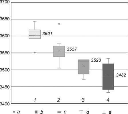
Fig. 1. Plot of uncalibrated values to determine statistical outliers and medians.
1–4 – chronostratigraphic groups.
a – outlier (point of single data); b – average; c – median; d – maximum; e – minimum.
Dating results
At the first stage of the analysis (before calibration), the presence of statistical outliers was checked by plotting a range diagram for the series as a whole. Values were used without taking into account the standard deviation. This procedure reduced the number of dates used to 40, mainly due to deliberately older dates (MAMS-11649, 3989 ± 67 BP; MAMS-11654, 3976 ± ± 53 BP; UGAMS-16777, 3760 ± 25 BP; UBA-26188, 3348 ± 36 BP). As a result, one object turned out to be outside the analysis—well 2/8, with a single date*.
Work on identifying statistical outliers (“Outlier”) within the groups showed (Fig. 1) that some values that do not have a reliable cultural context do not fit into the main aggregates. Thus, one of the dates of well 6/1 (MAMS-15083, 3558 ± 28 BP) turned out to be much older than the results of dating the layers with the Srubnaya-Alakul ceramics located above and below in the stratigraphic column. It is close to the date of the layer that marks the termination of the functioning of this well (MAMS-27513, 3534 ± 31 BP). The presence of early materials within it is explained by the history of the place—the Srubnaya-Alakul building destroyed the Sintashta one.
*Its location and structure indicate chronological proximity to neighboring wells 2/7 and 2/9, which were probably built sequentially and belonged to the early period of development.
Another example, this time later concerning to the expected date (MAMS-10885, 3478 ± 27 BP), is associated with a coal sample from well 4/1*. For this object, there are four more dates obtained from the materials of the layers of debris in the bottom part and above. The batch does not pass the χ2 consistency test. If this value is rejected, the combined date is successfully formed, i.e. 3545 ± 11 BP, which, according to the results of calibration, provides intervals of 1920–1880 (1σ) and 1940–1780 (2σ) BC**. The reasons for this deviation are not clear.
Checking the consistency of the series within each of the four groups (phases) showed that they also contain outliers—far-distant extreme values: 3551 ± 28 BP (MAMS-15086), 3636 ± 26 BP (Hd-28458), 3471 ± 25 BP (MAMS-11653). With a high degree of probability, it can be assumed that this is not about dating problems, but about inaccuracies in the attribution of the context of the finds. In one case (MAMS-15086, 3551 ± 28 BP), this is well 5/1, for which dates were obtained from the drill samples, and there is a greater value for a stratigraphically earlier sample (MAMS-15087, 3592 ± 30 BP). In another case
Table 2. Results of the analysis of distribution of dates over chronostratigraphic groups
|
Group No. |
Number of dates (without outliers) |
Medians of uncalibrated values, BP |
Summation of probabilities |
|
|
68.2 % |
95.4 % |
|||
|
1 |
6 |
3601 |
2025–1920 BC |
2130–1880 BC |
|
2 |
14 |
3557 |
1950–1820 BC |
1980–1770 BC |
|
3 |
4 |
3523 |
1900–1770 BC |
1930–1760 BC |
|
4 |
11 |
3482 |
1890–1740 BC |
1920–1680 BC |
(Hd-28458, 3636 ± 26 BP), the outer rings of the tree are dated, but the date from a pinecone from the bottom of well 2/4 is much younger (MAMS-11661, 3548 ± ± 25 BP)*. Apparently, the dating of this object should be guided by a later result, and the deviation is associated with the effect of an old tree (unless, of course, the episodes of the construction and abandonment of the well are separated in time by many tens of years).
All other values form groups with distinct areas of overlap of uncalibrated values (taking into account standard error). This situation is repeated (more precisely, it is aggravated) when summing up the probabilities (“Sum probabilities”) for each of the groups (Table 2). The complex profile of the plots for some of them is a direct reflection of the nature of the calibration curve and, in part, a small number of statistical observations.
Cultural attribution of chronostratigraphic groups
The identified chronostratigraphic groups were attributed by ceramics from the infill or by overlapping structures clearly correlated with the development phases.
Group 1 includes four objects: three in the northeastern part of the settlement (2/1, 2/1a, 2/7), and one in the northern (5/1). The presence of ceramics of the Sintashta type in the average filling of wells 2/1 and 2/1a makes it possible to attribute this group of structures to the first construction phase associated with the Sintashta people.
Group 2 includes six objects: three in the northeastern part of the settlement (2/4, 2/9, 7/1), and three in the northern part (4/1, 5/4, 5/9). Also related to this period is the date obtained for the average filling of the earlier well 5/1, apparently confirming the time of its filling. Although the wells did not contain identifiable ceramics in their middle and bottom fillings, nevertheless, presumably they can be attributed to the Sintashta construction phase. The reason for this is the archaeological context of well 5/4: it was found under the ruins of the southern wall of building 5b and is associated with an earlier structure—Sintashta building 5c. Ceramics of the Sintashta type were found in the upper filling of this well. Above the shafts of wells 7/1 and 5/9, pits-furnaces were built in a later period. One (above the first object) contained ceramics of the Petrovka type, the other (above the second)— Sintashta and Petrovka (mainly). This circumstance allows us to conclude that the construction of the second group of wells could precede the Petrovka construction phase in time.
Group 3 includes four objects: one in the northeastern part of the settlement (2/5), and three in the northern part (5/2, 5/3, 5/10). In addition, a corresponding date was obtained for the foundation of a kiln pit above an earlier well 5/9. Analysis of the distribution of ceramic material in these structures shows a rather variegated picture. The typological composition of the ceramics collected at different levels of the shaft of well 5/10 allows us to conclude that the construction time of the object and both stages of its secondary use (utility pit and furnace pit) can be correlated with the Sintashta phase of the settlement’s functioning. A fragment of the Petrovka vessel was found in the furnace pit above the 5/3 well. Finally, the furnace pit above well 5/9 contained predominantly Petrovka-type ceramics. It can be assumed that the objects under consideration date back to the time when the Sintashta tradition was replaced by the Petrovka one. At least some of these wells may have been built and/or reused during the Petrovka construction phase.
Group 4 includes wells 6/1, 5/7, and 3/1. They were distinguished by their large sizes and were recorded from the uppermost horizons of the cultural layer in the form of deposits of a dark humus layer formed above the mine pits. For the facing of wells 3/1 and 6/1, stone slabs were used along with wood. These objects, apparently, stood open for a long time and gradually collapsed. After well 5/7 was abandoned, the
Table 3. Results of the simulation of chronological limits of phases and periods
Based on stratigraphic observations and the features of occurrence of the ceramic material, eight more objects that do not have radiocarbon dates can be confidently attributed to the Sintashta ceramics (1/1, 1/2, 2/3, 2/6, 2/10, 5/5, 5/6, 5/11). For example, fragments of the Sintashta dishes were found in the lower and middle filling of wells 2/10 and 5/11, as well as in the filling of pits-furnaces above the shafts of wells 1/1, 1/2, and 2/6. The clogged well 2/3, according to the authors of the excavations, chronologically preceded wells 2/1 and 2/1a. Wells 5/5 and 5/6 were reliably connected with the Sintashta building 5c and contained the corresponding ceramic material in their upper filling.
Well 15/1 was examined only in the upper part, where the predominant category of finds was Petrovka-type ceramics. It is possible that this object belongs to the Petrovka construction phase or precedes it. Well 2/2 was built, apparently, during the Petrovka period, the corresponding ceramics were found in the well’s middle filling.
Well 5/15, examined only in the upper part, on the basis of its size, nature of its filling, and the level of the first fixation can be confidently attributed as of Srubnaya-Alakul period.
Simulation results
In Russian archaeology, modeling is still rarely used (Schneeweiss et al., 2018; Chechushkov, Molchanova, Epimakhov, 2020), although it opens up new perspectives in evaluating large series of dates. One of the main tasks of the work was the construction of statistical models taking into account the available facts of stratigraphy. The selected groups were considered as successive phases: the first three were combined within the Sintashta-Petrovka period, the fourth was defined as an independent period. The Sintashta phases 1 and 2 were considered as a single line of continuous development, while the Petrovka (phase 3) continued this line. The model does not provide for the presence of chronological gaps between phases and periods.
In the process of defining the boundaries of periods and phases, it was found that some dates do not correspond well with the main series. This applies to both the earliest dates (Hd-28408, 3644 ± 31 BP; Hd-28458, 3636 ± 26 BP) and the latest (MAMS-27514, 3433 ± 25 BP; MAMS-11650, 3433 ± 25 BP). Another date (MAMS-27516, 3505 ± 24 BP) of the second phase was found among the “younger” ones. The calculation option after excluding these values quite adequately reflects the duration of the periods (Table 3): early (Sintashta-Petrovka)—maximum of 85 years (probability 95.4 %), late (Srubnaya-Alakul)— maximum of 61 years. The break between them was 37 years at most. The third (Petrovka) phase is separated from the two preceding Sintashta phases at about the turn of the 20th and 19th centuries BC (1897 (1σ) / 1906 (2σ) BC). Thus, its duration within the framework of the proposed model is approximately 30 years.
Earlier, a similar set of dates was analyzed within the framework of two models, including the assumption of a hiatus between two main periods (without dividing into three phases of the Sintashta-Petrovka period) (Chechushkov, Molchanova, Epimakhov, 2020: 13–14). Discrepancies in the results concern the assessment of the total duration of the settlement’s functioning and individual periods (in our case, it is longer), as well as some details, but the overall picture has not undergone significant corrections.
Conclusions
As a result of the study, it was possible to identify groups of wells corresponding to the main phases of the development of the Kamennyi Ambar settlement and to clarify the chronological framework of these phases and periods. The first two phases are associated with the Sintashta materials and, apparently, illustrate the continuous existence of the population within the boundaries of a densely built-up area. Unfortunately, the available data do not allow us to clarify the differences in the chronology of the southern and northern halves of the settlement, although it is obvious that the latter has a longer history (Epimakhov et al., 2016). The third phase is conventionally attributed to the Petrovka period. Although there are almost no “pure” Petrovka objects at our disposal, the appearance of ceramics of this culture correlates well with the stratigraphically late phase of the settlement’s functioning within the densely built-up area. Its duration, apparently, was shorter than that of Sintashta, which is confirmed by the smaller number of materials and dates.
Finally, the fourth phase, which completes the history of the settlement, within the framework of the
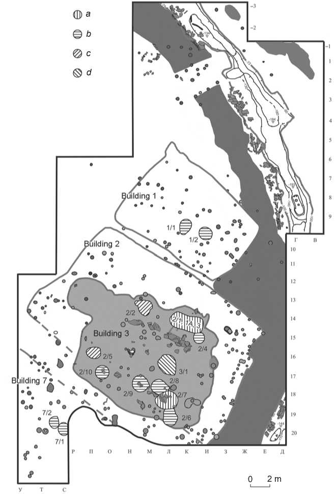
Fig. 2 . Localization of wells in excavations 1–5 according to the results of cultural and chronological attribution.
a – group 1; b – 1/2 and 2; c – at 3; d – group 4.
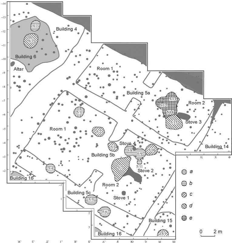
Fig. 3 . Localization of wells in excavation 6 based on the results of cultural and chronological attribution. a–d – see Fig. 2; e – the group is not defined.
proposed statistical model, begins after a short break and illustrates the life of the settlement for about half a century. The new dwellings were built as independent objects, but the early pits and the collapse of the outer wall and ditches were taken into account, which were well traced at the time of construction.
At least 18 wells (twenty-one, if the indirect data is taken into account) at the investigated area are associated with the Sintashta construction phase (groups 1 and 2). A significant number of objects confirm that this period in the history of the settlement was the longest. Numerous reconstructions of dwellings, traces of the transfer of walls, reliably recorded during the excavation process, and the richness of the cultural layer testify to this. The predominance of the earliest Sintashta wells in the northeastern part of the site may suggest that an initial populating of the site may not have taken place simultaneously, i.e. development on the investigated area began from the southeastern line*.
The Petrovka phase was very short, and there were only six wells associated with it. Remains of buildings of this time are so inexpressive and difficult to identify that, before excavations in the northern part of the site, the Petrovka phase was not separated from the Sintashta phase at all, although the sequence of cultural deposits was clearly recorded in the filling of the ditches (Panteleeva, 2020).
The location of the wells indicates that during the Sintashta-Petrovka period, a uniform cluster development model was maintained, despite traces of redevelopment. The wells were dug sequentially, forming “chains” along the central axis of the buildings, which were often closed by the Petrovka objects. This situation can be seen in the northeastern part of the site, where the earliest wells are located in the rear half of the dwellings, and the later ones (Petrovka) are shifted closer to the entrance (Fig. 2, 3). We also emphasize that we do not see significant differences in the design of the Sintashta and Petrovka wells—the technological tradition was clearly the same.
It is probably the wells that mark the earliest planning scheme that was lost during the reconstruction. Particularly expressive in this sense is the picture in building 2 with two lines of wells, apparently reflecting the existence of two earlier structures. A similar situation was observed in the northern part of the settlement: wells 5/4, 5/5, and 5/6 were found directly on the line of the southern wall of building 5b. An analysis of the excavation materials allowed us to conclude that these objects are associated with an earlier structure (building 5c).
In the final (Srubnaya-Alakul) construction phase, the picture is more variable: wells were built in dwellings, small utility rooms, and in open space outside large buildings. Wells of this period significantly differ from earlier ones in size and design.
In general, it can be concluded that there were no large chronological intervals between the construction phases. On the one hand, this is confirmed by the radiocarbon dates obtained for different objects, which have a significant mutual overlap. On the other hand, the continued use of the original layout of buildings in the Petrovka period (including the localization of wells) indicates that the ruins of the previous structures, at a minimum, were still clearly visible on the surface. The same can be said about the final period of the settlement’s functioning. Although in the Srubnaya-Alakul period, the principle of cluster development gave way to chaotic outbuildings, and large residential buildings were often erected in the contours of the previous foundation pits.
The first half of the 19th century BC can be considered as the time of the most intense cultural processes. It was during this period that there was a consistent change in cultural traditions, traces of which were recorded in the materials of the monument. The total duration of the history of the settlement did not exceed one and a half centuries. This conclusion can be adjusted by using all the dates of the site, but, as shown above, even the cultural attribution of specific samples from wells is not always clear; for finds from filling pits or ditches, this problem is even more relevant.
Acknowledgments
The study was supported by the Russian Science Foundation, Project No. 20-18-00402 (A.V. Epimakhov); under the state budget theme of the Institute of History and Archaeology of the Ural Branch of the Russian Academy of Sciences (L.N. Koryakova, S.E. Panteleeva).
