Zotino III: an early iron age metallurgical center in the Trans-Urals

Author: Borzunov V.A.
Journal: Archaeology, Ethnology & Anthropology of Eurasia @journal-aeae-en
Section: The metal ages and medieval period
Article in issue: 3 т.46, 2018.
Free access
Short address: https://sciup.org/145145384
IDR: 145145384 | DOI: 10.17746/1563-0110.2018.46.3.066-074
Text of the review article Zotino III: an early iron age metallurgical center in the Trans-Urals
The fortified settlement of Zotino III is located on the left bank of the Bagaryak River (right tributary of the Sinara River), two kilometers east of the village of Zotino (Kaslinsky District, Chelyabinsk Region), at the border of the eastern slope of the Urals and the Trans-Urals forest foothills (Fig. 1, 2). The site lies on the summit of a high (ca 40–43 m) rocky promontory. The famous Zotino karst cave and the grotto of the same name with an Upper Paleolithic site are on the southeastern side, in the lower part of the cliff.
The area of the fortification is subtrapezoidal, sloping, with a height difference reaching 8 m. It is oriented along the SW-NE line and is bounded by steep and vertical
cliffs on three sides. On the northeastern inland side, it is enclosed by an arcuate rampart and outer ditch with a passage about 2 m wide (Fig, 3, I ). The length of the rampart is 73–75 m; its width is 4.0–4.5 m, and its height reaches 0.75 m. The width of the ditch is 2.5 m; the depth is 0.2–0.3 m. The surface of the promontory is open and sodded. At the edges of the site, the cultural layer tapers out and rock outcrops are visible. The site has a length of 80 m, and a width of 50–66 m, occupying an area of 3800 m2.
In 1770, I.I. Lepekhin, the Head of the Second Orenburg Physical Expedition of the Russian Academy of Sciences, visited the mountain and made a description of Zotino Cave (Prodolzheniye…, 1822: 210). The fortified settlement was discovered in 1911
In 1974, the archaeologist V.T. Petrin with the participation of the biologist N.G. Smirnov excavated the Zotino grotto and its pre-entry area. Upper Paleolithic materials were found in all five layers of the site, but mostly concentrated close to the lower clay horizon. Fragments of hand-molded pottery of the Early Iron Age and fragments of modern pottery were found in the highly mixed upper humic layer (Petrin, 1974; Petrin, Smirnov, 1977: 56, 61–67). At that time, V.T. Petrin and T.N. Nokhrina made an exploratory ditch (12 × 3 m), oriented along the SW-NE line, and two exploratory pits above the cave, in the northern corner of the fortified settlement that they called “Nizhnezotinskoye” (Fig. 3, I ). The report of 1974 does not contain information about those excavations. The collection of finds (No. 1371, collection of the Basic Research Laboratory at the Ural Federal University) contains a copper or bronze knife, fragment of the tip of an iron knife, stone disc with a spiral solar ornamental decoration and hole in the center (Fig. 4, 4 , 8 , 15 ), two objects of unidentified purpose made of non-ferrous metal and iron, two bone artifacts, and 38 pottery fragments. All these items belong to the Itkul culture of the Early Iron Age. The pottery is represented by the fragments of vessels of two groups: all-purpose vessels decorated with a comb stamp (“the Itkul first type”), and production undecorated vessels.
In 1976, the author of this article discovered another fortified settlement of the Early Iron Age in the vicinity of Zotino, and a second defense system was found at the Zotinskoye Nizhneye Pravoberezhnoye site. These sites received new names with Roman numerals: Zotino I–IV (see Fig. 2, 2–5 ). In 1976–1978 and 1980, excavations were made at these sites and at the neighboring Kolpakovo fortified settlement. The results of research at Zotino I (Krasny Kamen) and IV have been fully described (Borzunov, 1981, 1993); the information about the other sites has been presented briefly (Borzunov, 1977, 1978, 2008a, b).
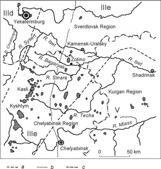
Fig. 1. Present-day natural and climatic zones in the research area (Gorchakovsky, 1968: Fig. 35).
III – forest, taiga: IIId – southern taiga, IIIe – pre-forest steppe pine and birch forests; V – forest steppe.
a – boundaries of zones and subzones; b – eastern boundary of the Ural Mountains; c – boundaries of the regions.
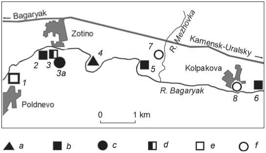
Fig. 2 . Fortifications of the Iron Age and settlements of the Late Bronze Age in the vicinity of the villages of Zotino, Poldnevskoye, and Kolpakovo.
1 – Poldnevskoye; 2 – Zotino I (Zotinskoye Verkhneye Pravoberezhnoye, Krasny Kamen); 3 , 3a – Zotino II (Zotinskoye Nizhneye Pravoberezhnoye, 1st and 2nd areas, respectively; 4 – Zotino IV; 5 – Zotino III (Zotinskoye Levoberezhnoye, Nizhnezotinskoye, Lepekhinskoye, Vesek); 6 – Kolpakovo fortified settlement;
7 – Mezhovka; 8 – Kolpakovo (unfortified settlement).
a–d – fortified settlements and fortified dwellings with pottery: a – Gamayun-type, b – Gamayun- and Itkul-type, c – Gorokhovo-type, d – Gamayun-, Itkul-, and Vorobyevo-Gorokhovo-type; e – unattributed fortified settlement; f – settlements (unfortified) of the Bronze Age.
4 Excavation I
Z////////////////
Excavation I
"Rivets'1
R. Bagaryak
Production ground
Depression (hearth II)
Excavation II
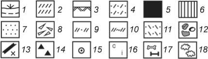
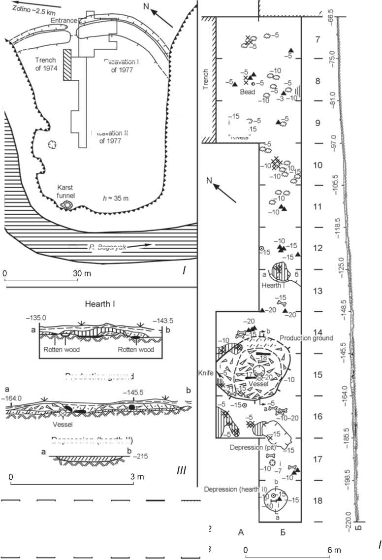
Fig. 3 . Zotino III fortified settlement.
I – site plan; II – plan and section of excavation II of 1977; III – sections of archaeological structures.
Depth marks on the plan indicate the distance from the present-day surface; depth marks on the sections indicate the distances from the zero point.
1 – sod and upper dark gray (black) podzol; 2 – light gray sandy loam with inclusions of ash; 3 – rock formations (natural layer); 4 – light brown sandy loam; 5 – black carbonaceous layer; 6 – calcined yellow and reddish sandy loam; 7 – light yellow sandy loam; 8 – calcined red clay coating; 9 – dark gray sandy loam (ancient buried podzol); 10 – sandy loam of dark ashy color with inclusions of ash and charcoal; 11 – yellow-brown sandy loam; 12 – stones, rubble, pieces of limestone;
13 – charred logs, poles, and large charcoal; 14 – pottery fragments; 15 – ceramic disc with a hole in the center (“handwheel”, “spindle whorl”); 16 – objects of copper (c) and iron (i); 17 – animal bones (unburned and charred); 18 – slag.
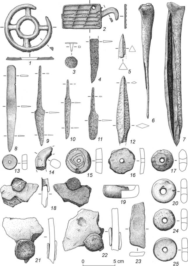
Fig. 4 . The Itkul assemblage from the Zotino III fortified settlement: materials from the excavations by V.T. Petrin in 1974 ( 4 , 8 , 15 ) and V.A. Borzunov in 1977 ( 1–3 , 5–7 , 9–14 , 16–25 ). Drawings by V.I. Stefanov.
1 , 2 – copper; 3 , 4 , 9–11 – iron; 5–7 , 12 – bone; 8 – copper or bronze; 13 , 15 , 17 – talc stone; 14 , 16 , 20 , 24 , 25 – ceramic; 19 , 23 – stone; 18 , 21 , 22 – iron, ceramic.
In 1977, the author of the present article made two adjacent excavations at the Zotino III fortified settlement over a total area of 405 m2: one (I) on the eastern section of the defense system and the adjacent sections of the settlement area; the other (II) along the northwestern edge of the site. Both excavations were oriented along the SW-NE line. The second excavation was adjacent to the exploration trench of 1974 (see Fig. 3, I ).
Defense system of the fortified settlement
The rampart and remains of the defense wall. The investigated section of the slightly spread-out, stony mound with a maximum height of 0.7 m rested on a horizon of partially destroyed buried soil 10–25 cm thick, which included layers of dark gray and light brown sandy loam with fragments of Itkul pottery. The mound was covered with black podzol 5–30 cm thick together with rubble and large pieces of limestone. A thin (3 cm) layer of sod lay on top. The body of the rampart was composed of large gravel (the layer was 5–60 cm thick), sandy loam of dark ashy color with the inclusions of ash and charcoal (8–15 cm), and yellow-brown sandy loam (10–15 cm). The remains of charred wooden structures were found in these strata, mainly in the ashy sandy loam. Spots of calcined yellow and red sandy loam (grids Б–Е/3) were visible over these remains. Fragments of Itkul pottery, which was identical to the finds from the lower horizon, were found in the mound at different depths, but slag was not detected. The total thickness of the cultural layers ranged from 0.3 to 0.9 m. The natural soil consisted of rock formations and monolithic rock (Fig. 5).
At the entrance to the fortification (grids Б/2–3), the rampart narrowed sharply. Two fragments of the neck of a
vessel similar to the Vorobyevo pottery were found there in the northwestern wall of grid Б/2, at a depth of 17 cm. A pottery fragment which was discovered in grid Б/3 (depth of 25–30 cm) might have belonged to the same vessel. Animal bones were deposited at the edges of the spread-out mound in grids Б–В/3; a piece of slag was found in the southern corner of grid Е/3 (depth of 45 cm). In the upper layers of the rampart, present-day objects were found, including an iron rectangular plate (grid Е/10, depth of 10 cm), four-sided forged nail (В/3, depth of 25 cm), and dark red cubic plastic bead (grid Д/2, depth of 15 cm).
Fragments of charred birch logs 10–20 cm in diameter and pieces of birch-bark were found in grids В–Д/3 at a depth of 20–45 cm from the surface of the rampart. The logs lay in two or three rows almost parallel to the mound of the rampart. The width of the scattering of the logs was 1–2 m.
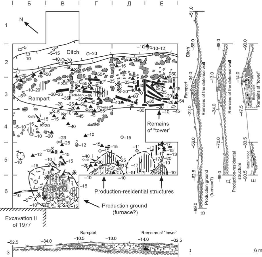
Fig. 5 . Plan and sections of excavation I of 1977 at the Zotino III fortified settlement (depth marks on the plan indicate the distance from the present-day surface; depth marks on the sections indicate the distances from the zero point). Legend same as for Fig. 3.
Tower-like structure. An original object was found in the filling of the rampart, in grids Д–Е/3 12 m to the southeast of the entrance to the fortified settlement (Fig. 5). It was a cage-like structure built of logs 12–18 cm in diameter, subsquare in plan view, and measuring about 3.0 × 2.6 m. This structure was built into the line of defensive wall, and might have slightly protruded in the inland direction. The logs of the three lower layers have been found, and the method of their placement has been identified: one layer on top of another in a structure like a well. The ends of the logs at the corners protruded 10 cm beyond each other. They might have been specially cut for that (in a dovetail notch). When erecting more late, more perfected, and the most stable cribworks, the ends of the logs would also protrude; for that, notches of various shapes were hewn out (a saddle-notch facing upwards or downwards with three varieties: flat-bottomed notches on the top and bottom of the log, a saddle notch facing upwards, and a cribwork of alternating thick and thin logs). The space of the tower-like structure was filled with crushed stone including the fragments of charred logs from the upper layers, and was covered with yellowbrown sandy loam, calcined yellow-pink sandy loam, and pieces of limestone. The remains of the collapsed “tower” in grid Е/3 contained fragments of Itkul pottery (depth of 15–55 cm), and a fragment of a three-edged bone arrowhead (depth of 35 cm) (see Fig. 4, 5). The fragments of a crushed Itkul vessel (depth of 60 cm) were found under the eastern corner of the structure in the layer of the early settlement.
Crepidoma of the rampart, walls, and “towers”. From the inland side, the base of the walls and of the tower-like structure was reinforced with a banking of coarse crushed stone and slanting limestone slabs. The slabs were located in a band running parallel to the outer edge of the embankment and extending from the entrance towards the eastern part of the rampart (1.0–2.4 m) (see Fig. 5).
Ditch. A small section of the ditch, which was adjacent to the inland edge of the rampart on the outside, was studied in the grids Б–Е/2 and В/1. Its width (1–2 m) and depth (0.2–0.4 m) increased in the southeastern direction from the entrance to the fortification. The ditch was segment-shaped in cross-section. Natural rock formed its base. The ditch was filled with black podzol, covered with sod with rare inclusions of slag, animal bones, and fragments of Itkul pottery (see Fig. 5).
Area of the fortified settlement and its structures
Production and production-residential structures, which were located in two isolated groups, have been identified on the cleared interior space of the fortified settlement.
Stratigraphy of the main part of the fortification. A layer of dark gray podzol (3–10 cm) with charcoal, slag, and pottery fragments lay under the sod layer (1–3 cm) outside the structures. In the remaining areas under the sod and podzol (2–5 cm), components of two types were found: 1) hearths and pits 10–20 cm deep in rocky ground and filled with calcined or ashy sandy loam; 2) production adobe platforms 15–25 cm high, under which the remains of the early cultural horizon were detected. That horizon was represented by thin (2–5 cm) layers of buried sandy loam (of light yellow color and in some places of calcined yellow and red-yellow color), containing animal bones and fragments of Itkul pottery. The total thickness of the cultural horizon at the site ranged from 10 to 45 cm. The natural layer was calcareous rock (see Fig. 3, II , III ; 5).
The first group of structures was located in the northeastern part of the settlement, in the immediate vicinity of the rampart (excavation I, grids В–Е/5, В/6), at a distance of 3–5 m from it. One structure was cleared almost completely, and three were cleared partially (see Fig. 5).
A production ground has been identified five-six meters to the south of the entrance to the fortification, in grids Б–В/5–6. The remains of the structure were an adobe platform, oval in plan view and segment-shaped in cross-section, oriented in the meridional direction and measuring 4.9 × 3.6 m with a height of 0.04–0.25 m. The depth from the present-day surface, where the structure was visible, was 15–30 cm; the size of the bottom part was 0.8 × 0.4 m. A large (2.5 × 1.8 m) cup-shaped depression (0.12–0.15 m), filled with calcined pinkish and yellowbrown sandy loam with inclusions of charcoal, was in the center. A cluster of stones (1.5 × 1.0 m) was unearthed within its boundaries at a depth of 10–25 cm. Bones of animals and a collapsed Itkul undecorated production vessel were found near it, at a depth of 15–17 cm. The explored depression resembled a hearth pit, but most of all, that of the inner chamber of a multifunctional (metallurgical and blacksmith) melting furnace (cf.: (Borzunov, 1981: 113, 116, fig. 1, b)). To the south of the furnace, on the adobe platform, spots of calcined loam were found. Pieces of slag, a fragment of the wall of a production vessel with an iron “rivet”, three ceramic discs with holes in the center, and a round stone cup (see Fig. 4, 19, 20) were discovered within the structure and around it, in addition to fragments of Itkul vessels and animal bones. The closest parallels to that cup are stone portable altars and clay hand-molded ritual censers from the Sarmatian burial mounds of the Southern Urals (Moshkova, 1963: Pl. 11, 21, 22–24; Smirnov, 1975: Fig. 19, 7; 23, 9; 1989: 168, 174, pl. 69, 15, 62, 63). Fragments of charred poles 10–20 cm in diameter were found in the remains of the adobe structure. Animal bones were deposited in the layer of dark gray sandy loam under the platform (grid В/6, depth of 20 cm).
An oval depression (0.8 × 0.7 cm) filled with gray sandy loam was found 1.3 m to the north of that object, in the grid Б/5 (depth of 10–16 cm). Two adobe platforms and a pit between them were partially unearthed in grids Г–Е/5. The upper level where these structures were detected was 10.6, and 12.0 cm. The platforms consisted of calcined pinkish-red coating. The northeastern platform was segment-shaped in plan view and measured 3.1 × 1.0 m; on the northeastern side, it was outlined by calcined yellow-brown and pinkish sandy loam with the inclusion of charcoal. The southwestern platform was semi-oval (1.3 × 0.9 m). The pit was rounded; it was 2.3 m in diameter and 0.25 m deep. Its rock base was covered with light gray, sometimes pinkish sandy loam, 5–7 cm thick. A thin (3 cm) interlayer of rotten wood was found in the northeastern part of the depression. All objects were covered by a horizon of dark gray podzol with sod (6–12 cm). Fragments of Itkul pottery, including a large production vessel, iron knife, bone arrowhead, and five “disc-handwheels” (four ceramic and one made of talc stone (see Fig. 4, 9 , 12 , 17 , 25 )) were found in the pit, on the platforms, and around them, at a depth ranging from 13 to 40 cm. Fragments of charred poles 7–15 cm in diameter lay near the adobe platforms.
Finds were more numerous and diverse between the rampart and the components of the first group, and included broken dishware, animal bones, pieces of slag, a bone perforator, iron knife, two copper objects with casting defects—a rectangular plate with ornamental decoration and an openwork wheel-like plaque (see Fig. 4, 1, 2, 6, 10).
The second group of structures was located in the western part of the settlement (excavation II, grids А/14– 16, Б/12–18), at a distance of 17–18 m from the first group, and consisted of an adobe platform, two hearths, and a pit (see Fig. 3 , II , III ).
The production ground in grids А–Б/14–16 was built on the ancient soil layer (buried dark gray sandy loam 3–8 cm thick) and covered with a thin (3–5 cm) sod horizon with dark gray podzol. The natural layer was rock. The production ground was made of adobe; it was calcined, oval in plan view, lenticular in cross-section, measuring 6.0 × 4.2 × 0.23 m, and was oriented along the WNW-ESE line. Two charred logs 84 and 195 cm long and 18– 20 cm in diameter were found in a coating at a depth of 17–18 cm. Interlayers of calcined loam were observed on the northern and western sides of the area. The horizon below the platform was also calcined. A round depression (0.8 m in diameter, 0.18 m in depth) filled with light brown sandy loam was located in the center of the structure. Two limestone tiles lay on the bottom. The bottom part of an Itkul production vessel with an animal bone inside was found under the tiles in the layer of buried soil (depth of 19–20 cm). Fragments of Itkul pottery, animal bones, a fragment of an iron knife, ceramic “disc-handwheels” (an intact disc made of a vessel wall and a fragment of a clay hand-molded disc (see Fig. 4, 11 , 14 , 24 )) were found on the territory of the structure and around it.
Hearth I in grid Б/12 was covered by dark gray podzol and sod. The depth where the hearth was observed was 8–28 cm. The hearth was of irregular oval shape (1.4 × 1.2 m), and was slightly deepened into rocky ground on its western edge. The hearth was filled with calcined light brown (sometimes pinkish and yellow-brown) loam with charcoal. The bottom was covered with a thin (3–4 cm) carbonaceous layer. Rotten wood was found at the edges of the calcined soil. A lens of light yellow sandy loam was discovered under the central part of the hearth. Fragments of a large Itkul production vessel, ceramic “disc-handwheel”, and bone dagger-like point were found 1.5–2.0 m to the northeast of the hearth (see Fig. 4, 7 , 16 ).
Hearth II in grid Б/18 was cup-shaped (1.8 × 1.8 × × 0.15 m); it was dug in rock, was filled with light gray carbonaceous sandy loam with the inclusions of calcified bone, and was covered with dark gray podzol and sod (15 cm). The filling contained three fragments of undecorated Itkul pottery, a “handwheel” of talc stone (see Fig. 4, 13 ), and a small iron plate.
A subrectangular (2.2 × 1.2 m) pit (depth of 0.13 m) oriented in the meridional direction, was cleared between hearth II and the production ground in grids Б/16–17. The bottom was uneven and bumpy; the pit was filled with light brown sandy loam. Pieces of calx and charcoal spots were present on the northwestern side of the pit. This pit could have been used for economic or production purposes.
Fragments of Itkul pottery, a whetstone, and an iron nail-like object with a round cap, apparently an awl or pin (see Fig. 4, 3 , 23 ), were found between the pit and hearth II in grid Б/17.
Space between the two groups of structures . Numerous pieces of iron slag and fragments of Itkul pottery were found under the sod in grids А/7–9, Б/7–11, located in a thin (5–18 cm) layer of dark gray podzol covering a layer of natural rock (see Fig. 3, II ). A small spherical (0.5 cm) cornelian bead (grid А/8, depth of 7 cm) and three wall fragments of production vessels with iron “rivets” (grid А/9, depth of 15 cm) (see Fig. 4, 18 , 21 , 22 ) were also found in this area.
Finds
The material complex of the site has been analyzed in a special article (Borzunov, 2018). The current publication will list the main categories of the inventory (see Fig. 4) and other finds. Itkul pottery of the first type, a bone three-edged arrowhead, and animal bones were found in the layer of the early settlement under the rampart; Itkul dishware, including production pottery was discovered in the mound, and animal bones and slag were found in the ditch. Fragments of Itkul dishware (of the first type) and production pottery, a ritual (?) flat-bottomed cup of talc stone, ceramic and clay discs with holes in the center (probably elements of a bow-type device for procuring fire), a bone perforator, dagger-like blade, copper or bronze wheel-like cast product (personal adornment or psalium), and rectangular ornamented buckle with a hook, heavily worn iron knives and shards with iron “rivets” of indeterminate purpose, as well as animal bones and slag, were found on the ground of the fortified settlement. Part of the Itkul pottery and animal bones lay underneath the adobe platforms. An imported antique bead made of orange carnelian was found near the rampart. Animal bones belonged to wild and domestic animals: wolf, bear, roe deer, elk, large and small cattle, and horse (definition by P.A. Kosintsev). The remains of domestic animals prevailed (227 bones from 18 individual animals as compared to 71 bones from 16 individual animals). The majority of bones in the collection belonged to horses (159 bones from eight individual animals) and roe deer (52 bones from 10 individual animals) (Borzunov, 1982: 106, tab. 5; Kosintsev, 1986: 81, 83, 89, tab. 1, 19 ). The Gamayun (7th–4th centuries BC), Vorobyevo, and Gorokhovo (6th–2nd centuries BC) pottery of the Early Iron Age, as well as medieval Bakal pottery were represented by isolated finds. The Itkul assemblage was dated to the 4th–2nd centuries BC.
Discussion
This settlement of the Early Iron Age was founded on a previously uninhabited site. It was used for a short period of time, without an artificial defensive system. This is evidenced by the presence, under the rampart, of a thin soil layer with rare fragments of Itkul pottery, including production pottery, and by animal bones and the fragment of an arrowhead.
Soon, the early settlement turned into a specialized metallurgical center of the Itkul culture, and was fenced off with a defensive system on the inland side, at the base of the promontory. Fortifications consisted of a two-row wall ca 2 m wide, filled with crushed stone in its lower part, and fortified with limestone blocks on the outside. Judging by the remains of birch-bark, the wall was built of birch logs. Yet, the possibility of using pine typical of the relict pine woods on the opposite bank of the river cannot be excluded. Theoretically, it can be assumed that the inner belt of the defensive wall was lower than the outer belt serving as a pedestal for a platform made of poles, on which guards were periodically on duty. Notably, the protective wall was not of a stockade type (vertical structure), but of a horizontal placement of logs. The erection of palisades on rocks was extremely difficult or even impossible. This distinguishes the Itkul and Gamayun fortifications of the mountainous TransUrals from the southern taiga and forest-steppe fortified settlements of the Tobol-Irtysh region, where defensive systems were built on sandy soils.
The inland wall of the Zotino III fortified settlement was quite ordinary: it was arcuate in plan view and had one passageway. The only unusual feature was a subsquare cage-like structure, slightly protruding from the outer layer of logs of the wall. It may be interpreted as the simplest defensive and watch tower. Bastion-tower structures along the perimeter of walls were typical of the Vorobyevo, Sargatka, and especially Gorokhovo fortifications. They occur in single numbers in the Gamayun and Itkul fortifications, and have been found only on the Bagaryak River (Zotino II fortified settlement, 1st system, and possibly the Dalneye Bagaryak fortified settlement). The roots of this specific element go back to the defense architecture of the Chalcolithic to Bronze Age of Central Asia and the Middle East. Bastion and tower structures became widespread among the forest-steppe population inhabiting the Tobol-Irtysh region in the Early Iron Age from the 6th–4th centuries BC to the 1st–3rd centuries AD, and resulted from the southern semi-nomadic Ugrians’ borrowing this innovation from the Iranian-speaking tribes of the Aral Sea region (Chirikrabat, Dzhetyasar, and Kyuzeligyr cultures, Khwarezm) (Stoyanov, 1989: 99; Borzunov, 2002: 94–95; 2014: 401).
The outer ditch of the Zotino III fortified settlement was narrow and shallow, with a rocky base. Most likely, it was a drainage ditch, which played practically no defensive role. Over time, people started to throw pieces of slag, animal bones, and broken pottery into the ditch. A pattern has been established: the thicker and higher the adjacent section of the rampart was, the wider and deeper was the ditch. This indicates that stones for the crepidoma of the mound were taken from the ditch. The layer of the early Itkul settlement on both sides of the embankment was completely cut off in the process of digging that ditch and constructing the defensive wall. Most of the perimeter of the promontory apparently did not have artificial defensive structures, and was protected only in a natural way by the very steep or vertical slopes of the cliff.
All unearthed peripheral areas of the Itkul fortified center contained remains and structures associated with the production and processing of non-ferrous and ferrous metals, including slag, crucible ceramics, iron and copper products, adobe platforms for metalworking, as well as production and residential structures. Most of the slag occurred between the unearthed adobe platforms; slag was not found in the rampart. It is known that the Itkul production grounds were located next to metallurgical furnaces. Judging by the similar Itkul settlement of Serny Klyuch on the upper reaches of the Ufa River, where the remains of 19 adobe melting furnaces and two adobe platforms for metalworking were discovered (Borzunov, 1998), it can be assumed that all central areas at Zotino III were occupied by metallurgical structures, such as production grounds, blacksmiths’ workshops, and furnaces. One object similar to a furnace was found near the entrance, in grid Б–В/5–6. However, collapsed adobe furnaces with frames made of birch poles, similar to the one discovered at the nearby fortified settlement of Krasny Kamen (Borzunov, 1977), were not found. The remains of oval adobe platforms look more similar to those excavated at the Serny Klyuch site.
It is unlikely that all the fortified settlements which have been studied in the vicinity of the village of Zotino functioned simultaneously. Judging by the pottery and material complex, the earliest of these sites was the Gamayun Zotino IV site, which existed in the 7th to early 6th century BC. The Gamayun Zotino II site (1st area) with peripheral Itkul components was dated to the 6th– 5th centuries BC. The subsequent Zotino I site (Krasny Kamen) with the Gamayun, Itkul, Iset, and Vorobyevo-Gorokhovo pottery was dated to the 5th–4th centuries BC. The latest sites (4th–2nd centuries BC) are the Itkul Zotino III fortified settlement and the 2nd area of the Zotino II site with the Gorokhovo pottery.
The Zotino III fortified settlement was a typical seasonal fortified center of the Trans-Urals metallurgists, and one of the easternmost outposts of the mountainous Ural Itkul population. Downstream on the Bagaryak River, only one site with Itkul pottery of the first type occurs—the Kolpakovo fortified settlement, founded on the ruins of the Gamayun fortification (excavations by K.V. Salnikov in 1953 and V.A. Borzunov in 1978). Further to the east and southeast, along the lower reaches of the Sinara River and at the Karabolka River, they were offset by the westernmost fortified settlements of the Gorokhovo culture of the 5th–2nd centuries BC.
Acknowledgments
This study was performed under the Public Contract of the Ministry of Education and Science of the Russian Federation, Project No. 33.7280.2017/БЧ (“The Urals and Western Siberia in Ancient Times”).
