A Bronze Age site on the northern coast of West Java

Author: Yondri L., Tabarev A.V., Popov A.N., Triwurjani Rr., Umar D.Y.Y., Taniardi P.N., Susilowati N.
Journal: Archaeology, Ethnology & Anthropology of Eurasia @journal-aeae-en
Section: The metal ages and medieval period
Article in issue: 3 т.52, 2024.
Free access
This study describes an early site on the northern coast of West Java, affected by the Austronesian culture—Subanglarang near Binong in the Subang Regency. Geologically, during the 2000–1000 BP interval, it was part of the coastline of the northern coast of West Java, situated more than 5 m asl. During the 2013 surveys and excavations in 2016 and 2018, five burials were revealed. On the basis of the fragments of red-slipped pottery, pickaxes, beads of various shape and size, and metal weapons, the site is dated to the Bronze Age. Artifacts similar to those of early Austronesians were discovered. The analysis of various beads from Subanglarang attests to trade relations with other areas. Further excavations on the northern coast of West Java will hopefully shed more light on the life of the Bronze Age people of that area.
Short address: https://sciup.org/145147219
IDR: 145147219 | DOI: 10.17746/1563-0110.2024.52.3.075-081
Text of the scientific article A Bronze Age site on the northern coast of West Java
The Subanglarang site, which is administratively part of the Binong subdistrict area, is located approximately 20 km north of Subang city, at the edge of the Cijati stream, part of the low-wavy morphological area of the Subang Regency. This regency is divided by three large river streams, which all flow to the northern coast of Java: namely Cilamaya, Ciasem, and Cipunagara. The Cijati is one of the Ciasem’s tributaries (Silitonga, 1973). Subang region is part of the northern coast of West Java, and regionally is included in the Jakarta-Cirebon, Java Island, Indonesia. The Coastal Plain Block is formed from alluvial deposits, whose constituent material comes from the mountains of South Bandung (Bemmelen, 1949: 28). This condition causes the morphology of the region, which can be divided into three types of landscape: 1) coastal plains, 2) swamp plains, and 3) flood overflow plains. This landscape has a slope percentage of 0–2.4 % and an altitude of 0–4.8 m asl. The main vegetation is mangroves and coconut trees. The swampland area is affected by tides of seawater and is uninhabited. The flood
overflow plains area follows the flow of the Cilamaya River in the west, the Ciasem River in the middle, and the Cipunegara River in the east. The villages are scattered in several locations along these rivers, as well as along the irrigation canals and tributaries of the Ciasem and other rivers. The Ciasem River empties into Ciasem Bay in the Java Sea, precisely in the eastern part of Blanakan (Armin et al., 1980: 3–4).
The existence of the Subanglarang site as part of the northern coast of West Java in the past, especially in the period of 5000–1000 BP, can be seen from the reconstruction of changes in the northern coastline of West Java (Fig. 1) carried out based on data obtained from the General Bathymetric Chart of the Oceans (GEBCO) 2014 with a spatial distance resolution of 15 m. The extraction of elevation data ( x , y , and z coordinates) was exported using Global Mapper series 17 software and ArcGIS series 10.3 to produce a 3D-map in Digital Elevation
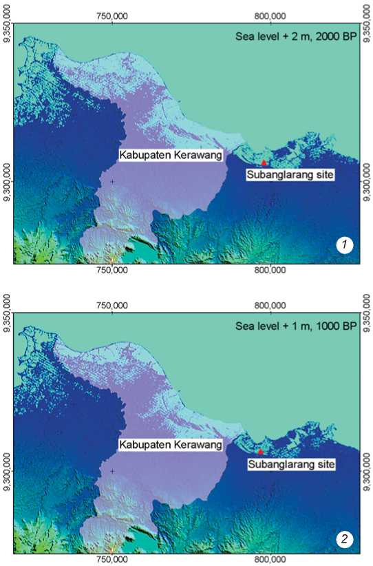
Fig 1. Location of the Subanglarang site in relation to the coastline in the northern part of West Java 2000 ( 1 ) and 1000 ( 2 ) BP (after (Zaim, Hascaryo, 2021: 88)).
Model (DEM) format. DEM maps were then reprocessed using the Triangulated Irregular Network (TIN) method to analyze spatial and height differences more accurately. By referring to the research from de Klerk (1983), which simulated the coastline change on the basis of a DEM map, its influence on West Java’s coastline development could be seen very well (Zaim, Hascaryo, 2021: 4–7).
Judging by the paleontological and archaeological studies that have been carried out so far in the Subang Regency, geomorphologically the evidence was generally found along the Ciasem River. In the upstream part, vertebrate fossils were found (Mulyana, 2004: 9); while in the downstream part, artifacts with Paleolithic characteristics, funnel axes, and kettledrums (Armin et al., 1980: 8; Herlina et al., 2020: 11), as well as pottery fragments and beads partly exposed to the surface owing to agricultural activities (Yondri, 2016: 35). Similarly to the location selection for residential area in the past, the land selection was not done randomly but in a patterned way. In the field of archaeology, the term “settlement pattern” refers to the evidence of the physical remnants of communities and networks within a given region (Hodder, Orton, 1976: 33). That evidence is used to interpret the way interdependent local groups of people interacted in the past (Hirst, 2020).
Study methods
The data used in this article were derived from the archaeological research carried out at the Subanglarang site and its surroundings in 2013 by a collaboration team from the cultural institution of the West Java government, the West Java Archaeological Office, and the Banten Cultural Heritage Conservation Office (Yondri, 2013: 1); the survey and excavation of the Subanglarang site conducted in 2016 by a collaboration team from the cultural institution of the Subang Regency government and the West Java Archaeological Office (Yondri, 2016: 2); and the analysis of the excavation materials conducted by a team from the West Java Archaeological Office (Ramadhani, 2019: 12; Yondri, 2018: 5). The data include the size, type, and technology of the artifacts, the chronology of occupation, and the environment in the Subanglarang area.
Spatial analysis was based on the dynamics of sea-level changes on the northern coast of West Java, which were reconstructed by a geological team through the simulation of the coastline changes during the Late Holocene (Zaim, Hascaryo, 2021: 4). Analysis of artifacts involved determining their technology, typology,
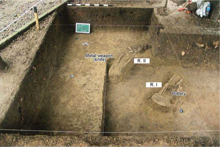
Fig 2. Skeletons R.I and R.II at a depth of 70 cm (after (Yondri, 2016: 24)).
and frequency in the context of the character and intensity of occupation of this territory. The site’s function was determined on the basis of the identification of cultural groups occupying the area, including the artifacts from each object, along with chronological data. Data interpretation then proceeded through several stages by developing explanations based on interrelated patterns of the site locations, the life support resources in the environment, and the characteristics of the finds, as well as the morphology and function of each object. These data are expected to elucidate the behavior of Austronesian speakers in relation to their concepts of the physical environment around the main site (Subanglarang).
Archaeological finds at the Subanglarang site
Archaeological finds from the Subanglarang site became the focus of discussion and the exchange of ideas between Indonesian and Russian scholars during the visit in 2019 as part of a scientific relations and joint publications program (see, e.g., (Nesterkina et al., 2022: 46)). The excavations have yielded various finds, both artifacts and anthropological materials. Five human skeletons were discovered: two in 2016, and three (plus a part of a mandible) in 2018. According to the order of detection, they were given the indices R.I, R.II … R.V. Skeleton R.III was the only anatomically intact one. It was found in a horizontal position, in a SE-NW orientation (Yondri, 2013: 15; 2016: 24; 2018: 16).
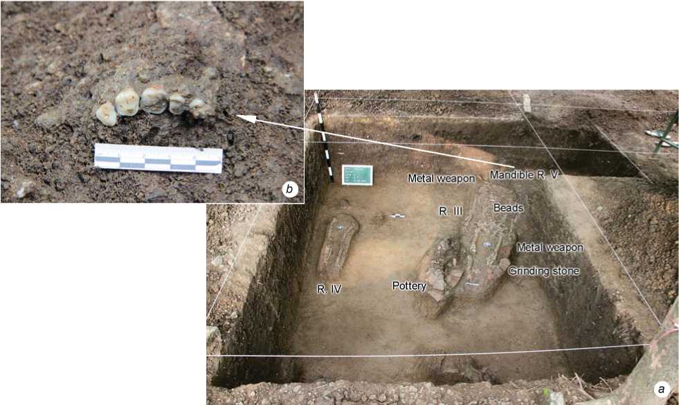
R.III was the most anatomically intact skeleton, although the bones were fragile. The tarsals, metatarsals, and phalanges were missing. The deceased was oriented with its head to the north-west (Fig. 3). Around the skull, there were grave goods, such as a metal weapon stretched over it, 40 cm long and 6 cm wide at the tip. In addition, there were also randomly scattered beads: round-shaped golden beads, single and double round-shaped glass beads, and multifaceted sandstone beads (Fig. 4).
>Ж
Bead:
Pottery
R. IV
а
Metal weapon Mandible R
Fig 3. Skeletons R.III, R.IV ( a ) and fragments of the R.V maxillary ( b ) at a depth of 60 cm (after (Yondri, 2018: 68)).
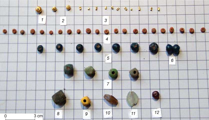
Fig 4. Beads (after (Yondri, 2018: 76)).
1–3 – golden; 4 – clay; 5 , 6 , 11 – glass; 7 – 9 – sandstone; 10 , 12 – carnelian.
tibia, and fibula (Yondri, 2018: 57). The most interesting is the burial position of R.III and R.IV closer to the surface than that of any other finds. This suggests that these burials were made later. In addition to golden beads, excavation yielded fragments of fragile golden plates. These were found in box SBLRG 1/8/2018.
The discovery of golden plates in prehistoric sites has never happened previously in coastal areas in West Java but at the Pasir Angin site, Cibungbulang District, in Bogor Regency. The site is located on a small hill with a height of ca 210 m asl, to the north of the Cianten River. The Pasir Angin site was researched in 1970–1973, and in 1975 by a team from the National Archaeological Research Center. Excavation results included artifacts made from stone, iron, bronze, clay, obsidian, and glass (square pickaxes; bronze and iron axes, including birdtail-shaped funnel axes; bronze sticks; bronze, stone, and glass beads; and spearheads), as well as pottery.
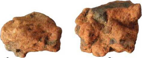
Other artifacts found in excavations at Subanglarang in 2016 and 2018 were fragments of terracotta that had been transformed so that the shape of the vessel was very difficult to recognize, andesite stones, and chunks of iron slag (Fig. 5, 6). The andesite stones seem to have been processed or sharpened to produce oval or rounded shapes. From the traces of use found in the middle parts of the stones, it could be estimated that in the past these were used as grinding stones or hammer stones in the pottery-production process. The chunks of iron slag were found in the form of blackish-brown lumps with hollow cavities caused by air bubbles that came out. The slag is very heavy, which points to the presence of iron content. Iron slags were also found during surface surveys. These are the residues from ironwork in this area (Yondri, 2016: 48; 2018: 83).
Since the 1970s, many residents have found beads and pottery in the Subanglarang area and its surroundings. In addition to agricultural activities, the finds were exposed to the surface owing to an illegal search for treasure (looting). Golden items people found were often traded. Other finds that had no sale value (stone bracelets and beads, glass, terracotta, pottery, square pickaxe, and worn-out bronze axes) were still stored within the community. Those finds were then collected and stored by Mr. Sonjaya. The community formed the Subanglarang Foundation to maintain the discoveries and the locality. Since the discovery of the tomb around the site, which is believed to belong to Prabu Siliwangi’s daughter, Nyai Subang Larang, the treasure-hunting activity has begun to stop. The local people seem to value the tomb more and think that all the artifacts they found while working on the land belonged to Nyai Subang Larang. They give their finds to Mr. Sonjaya to be stored.
There are quite a lot of artifact collections stored in the Subanglarang Foundation, including pottery, stone bracelets, jugs, pickaxes, and bronze axes, as well as beads (1569 spec.) of various shapes, sizes, and colors. When combined with the finds from excavations of 2013, 2016, and 2018, there are 1657 items in total, subdivided into 22 varieties (Ramadhani, 2019: 13; Yondri, 2018: 19; 2020: 58).
Subanglarang site as a trade-traces area on the northern coast of West Java
From the late period of prehistoric times, it may be noted that human and cultural migrations increasingly occurred
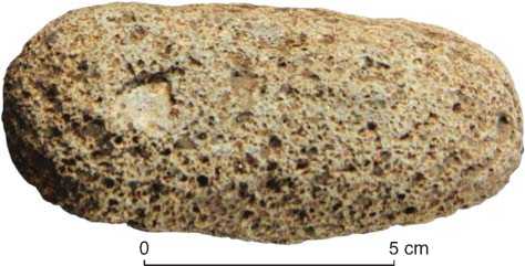
Fig 5. Andesite stone with traces of use (after (Yondri, 2018: 77)).
0 5 cm
Fig 6. Iron slag (after (Yondri, 2018: 78)).
in the territory of Indonesia, which is evidenced by artifacts originating from various regions, including those from outside the archipelago, from 2000–1000 BP. This might be because of Indonesia’s position between two continents, Asia and Australia, and two oceans, the Indian and the Pacific. In the past, it was a strategic crossing of exchange and trade routes. Indonesia’s position certainly intersects various areas, especially those easily accessible and not at high risk for berthing, such as the northern coastal area of West Java.
Judging by the results of geological studies carried out on the coastline by Y. Zaim and A.T. Hascaryo (2021: 4), there were three recorded changes on the northern coast of West Java: 5000 BP, 2000 BP, and 1000 BP. Around the period of 2000–1000 BP, territory of the site was closer to the coast. Looking at the soil layer in the 2018 excavation and correlating it with the outcrops on the edge of the Cijati River, it can be ascertained that it was a land area in the past. Therefore, it was natural for this location to be used for a settlement.
The question has arisen of who lived in Subanglarang in the past. The analysis of artifacts found during excavation and those stored in the Subanglarang Foundation has shown that some have the characteristics of Austronesian society, such as pickaxes or red-slipped pottery. The presence of pig bones and teeth in the materials from the site points to domestic animals. Radiocarbon analysis (14C) of cultural remains has provided a chronology of 1854±100 BP (Yondri, 2020: 8).
Some experts tried to elaborate theories about the distribution and origins of Austronesian culture based on studies of the typology of square pickaxes in mainland Asia and the Asian islands. The comparative analysis has revealed the similarity between the Malayan and Indonesian cutting tools. This led to the assumption that the Austronesian culture originated from the southern part of the Malayan peninsula (Duff, 1970: 145). Wilhelm G. Solheim proposed the theory of distribution of this culture based on pottery finds. His theory states that the initial areas of origin were the islands of Palawan, Western Borneo, and Sulu, marked by the discovery of pre-Sa-Huynh-Kalanay pottery. The area began to be settled from the early 2nd century BC (Solheim, 1975: 146).
The discovery of the main features of the Austronesian culture at the Subanglarang site is related to the Austronesian migration in prehistoric times to the northern coast of West Java. It is quite interesting to analyze more deeply the variety of beads found from surveys, excavations, and by residents around Subanglarang. Although no laboratory-specific analysis has been done, these can be compared with similar finds from various sites in Indonesia and with those described in “The History of Beads: From 30,000 B.C. to the Present” by L.S. Dubin (1995: 112). Noteworthy is the similarity of some beads found at Subanglarang with golden beads of the period around 200 BP from Greece; and the yellowish double-barreled beads show similarity in shape with the 100 BP Roman beads. Specimens made of precious/semi-precious stones (amethyst, quartz, carnelian) and cobaltblue glass are also similar to beads from mainland Asia. Generally, the beads circulating in South and Southeast Asia originated in India around the Early Metal Age (Nasruddin, 2017: 18).
Regarding the discovery of pottery (both simple and red-slipped pottery), as well as square pickaxes, both of which are part of Austronesian cultural products at the site; until the latest survey in the Subang Regency no traces of industry of either of the two categories of artifacts have been found.
Conclusions
On the basis of the above study results, it can be preliminarily concluded that the Subanglarang site, which is now situated along the Cijati stream (a tributary of the Ciasem River) on the northern coast of West Java, was once located in the coastal area. We assume that this site was inhabited by a group of people who had settled in the form of a community that had developed a funerary tradition accompanied by the placement of burial goods in the form of metal artifacts, beads, and clay vessels.
Judging by the results of the absolute dating of two skeletons found in 2016 in a layer of soil that was stratigraphically almost homogenous, we can determine the 14C-date of the finds as ca 1750 ± 70 BP. At that time, the inhabitants of the site had relations with outer regions in the form of both trade and exchange, as evidenced by various kinds of artifacts that did not originate from Subanglarang; including beads that have similar characteristics to those manufactured in Southeast Asia, Persia, Rome, and Europe.
Acknowledgments
Gratitude is extended to the local government of West Java and the Subang Regency, who have supported this research; especially to Prof. Dr. Yahdi Zaim and Dr. Agus Tri Hascaryo, who had carried out geological research in the northern part of West Java. Their findings have supported the team in interpreting the relationship between the Subanglarang site and its past geographical surroundings.
