A comparative study of the layout of Bronze Age fortified settlements in the Southern Urals (3rd to 1st millennia bc)
")
Author: Ulchitsky O.A., Bulatova E.K., Kazaneva E.K., Veremey O.M.
Journal: Archaeology, Ethnology & Anthropology of Eurasia @journal-aeae-en
Section: The metal ages and medieval period
Article in issue: 1 т.47, 2019.
Free access
Short address: https://sciup.org/145145415
IDR: 145145415 | DOI: 10.17746/1563-0110.2019.47.1.064-072
Text of the article A comparative study of the layout of Bronze Age fortified settlements in the Southern Urals (3rd to 1st millennia bc)
The results of historical, archaeological, ethnographic, and other studies in the Southern Urals (Aleksashenko et al., 1973; Zdanovich, 1988; Saveliev, Yaminov, 2004; Zdanovich, Batanina, 2007; Vinogradov, 2007; Epimakhov, Chuev, 2011; Koryakova et al., 2011; Fedorova, Noskevich, 2012; Bakhshiev, Nasretdinov, 2016) show that the general concepts concerning typology and genesis of the ancient structures in that region are still not sufficiently objective. Multiple scholarly interpretations of this issue have triggered the need for considering the available evidence about the fortified settlements of the Bronze Age in the Southern Urals using the comparative method.
In the period between 1969 and 2013, the ruins of over 20 fortified settlements of the Bronze Age were found in the Chelyabinsk and Orenburg regions, the
Republic of Bashkortostan, and Northern Kazakhstan, including Alandskoye, Andreevskoye, Arkaim (Aleksandrovskoye) (Zdanovich, 1988: 8–23), Bakhta (Batanina, 2004), Bersuat (Yagodny Dol), Zhurumbai, Isinei-1 and -2, Kamysty, Kizil-Chilik (Parizh) (Batanina, 2004), Kizilskoye, Konoplyanka, Kuisak, Olgino (Kamenny Ambar) (Koryakova et al., 2011: 71–74), Rodniki, Sarym-Sakly (Sharapov, 2017: 51), Sintashta-1 (Gening V.F., Zdanovich, Gening V.V., 1992: 17–43), Sintashta-2 (Levoberezhnoye) (Petrov et al., 2017), Stepnoye, Ustye, Chernorechye III (Vinogradov, 1995), Chekatai, Shikurtau (Batanina, 2004); Ulak-1 (Saveliev, Yaminov, 2004), Selek (Usmanov et al., 2013), Streletskoye, Shibaevo-1, Kamenny Brod, and Zarechnoye (Chechushkov, 2018: 11–18) (Fig. 1). The best known and explored fort is Arkaim, originally the Aleksandrovskoye fortified settlement (Aleksashenko et al., 1973: 15) (after the
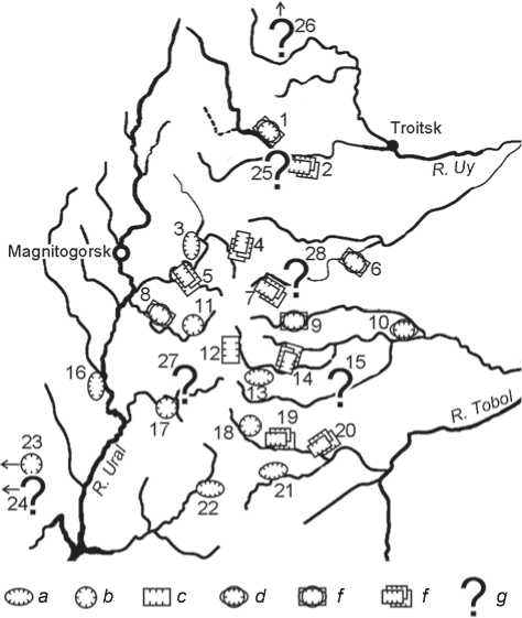
Fig. 1. Location of fortified settlements of the Bronze Age (18th–16th centuries BC) in the Southern Urals.
1 – Stepnoye; 2 – Chernorechye III; 3 – Shikurtau; 4 – Parizh (Kizil-Chilik); 5 – Bakhta; 6 – Chekatai; 7 – Ustye; 8 – Kuisak; 9 – Rodniki; 10 – Isinei; 11 – Sarym-Sakla; 12 – Konoplyanka; 13 – Zhurumbai; 14 – Kamenny Ambar (Olgino); 15 – Kamysty; 16 – Kizilskoye; 17 – Arkaim (Aleksandrovskoye); 18 – Sintashta I; 19 – Sintashta II (Levoberezhnoye); 20 – Andreevskoye; 21 – Bersuat (Yagodny Dol); 22 – Alandskoye; 23 – Ulak I; 24 – Selek; 25 – Streletskoye; 26 – Shibaevo I; 27 – Kamenny Brod; 28 – Zarechnoye.
a – oval, “Early Sintasta” type 1; b – circle, “Sintashta” type 2; c – rectangle, “Late Sintashta” type 3 or “Petrovska” type 4; d – twolayered, type 1/2; e – multilayered, mixed type 1/2/3; f – multilayered, type 3/3 (with habitable walls) or 3/4 (with continuous building pattern); g – structure and shape are not identified or no data.
name of the nearby village). Currently, archaeological works on ancient settlements have been conducted in the south of the Chelyabinsk Region and in the adjacent areas of the Eastern Orenburg region, Bashkortostan, and Northern Kazakhstan.
The main factors that influenced the emergence, development, and decline of fortified settlements in the Southern Urals have been identified and substantiated using scholarly methods (after dissertation research (Ulchitsky, 2006: 10–11)). These factors include: 1) the availability of copper ore deposits located near the surface and accessible for mining by primitive methods (Zdanovich et al., 2003: 140–141), and 2) specific features of the geographical environment of the region in the Middle Bronze Age, which influenced the formation of settlement systems. Early territorial formations typically manifest a symbiosis of nomadic (or semi-nomadic) and sedentary settlements. These factors resulted in a territorial relationship: mine – fortified settlement – unfortified settlements.
A set of planning and constructing methods, as well as presence of religious and funeral features, correspond to each fortified settlement. The area of a single structure within the defensive walls ranged from 8 (Isinei) to 34,000 m2 (Chernorechye). Fortified settlements served as territorial centers, strongly resembling the Early Medieval citadels “akr” and “kale” in the towns of Central Asia and Iran (Lavrov, 1950: 264–268). In the Southern Urals, such centers were located approximately at a distance of 20– 40 km from each other, and were often placed in river floodplains.
Despite the fact that fortified settlements were built according to a single model, which can be traced in their planning structure, three main types had been previously determined (Ulchitsky, 2006: 11): the Early Sintashta type, “classic” Sintashta type, and Petrovka type. Currently, after analysis of the Sintashta-Petrovka
fortified settlements in the Southern Urals (Ulchitskiy et al., 2016), four types have been determined: three types with habitable walls—the Early Sintashta, Sintashta, and Late Sintashta types, and the fourth with a continuous housing pattern—the Petrovka type (Fig. 1). Their subsequent influence on the settlements that were concentrated on the territory of present-day Kazakhstan and Central Asia has also been established. Gradually, the Petrovka type was transformed into a linear regular Sargary-Alekseevka building pattern.
The multilayered nature of the features under study has been established using stratigraphy and planigraphy, based on aerial photographs and layer-by-layer records in excavation pits. There were cases when a later fortified settlement partially overlapped an earlier settlement, and the configuration of the fortifications in the earlier settlement was not taken into account in the construction of the later settlement (Isinei-1 – Isinei-2, Stepnoye-1 – Stepnoye-2, etc.). There were also instances when settlement outlines in plan view completely overlapped the earlier outlines (see Fig. 1).
Reasons, which cannot be reliably established, led to active population movements and emergence of new building traditions in the Alakul and Fedorovka cultures. These traditions typically manifest a chaotic building pattern and large semi-dugout structures, of which traditionally two types are identified: “a farmer’s house” and “a potter’s house” (Zdanovich, 1988: 146).
123 5
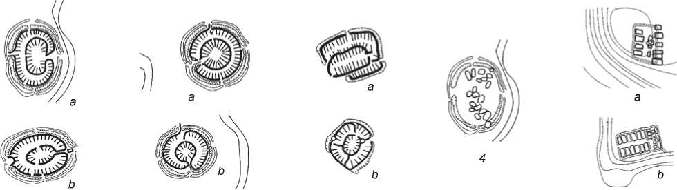
Fig. 2 . Layouts of fortified settlements and residential areas of the Bronze Age in the Southern Urals and Northern Kazakhstan. 1 – “Early Sintashta” type, late 3rd to early 2nd millennium BC: a – Kizilskoye, b – Bersuat; 2 – “classic” Sintashta type, 18th– 16th centuries BC; a – Arkaim, b – Sarym-Sakly; 3 – “Late Sintashta” (Petrovka) type, 17th–15th centuries BC: a – Andreevskoye, b – Kuisak; 4 – the Alakul and Fedorovka settlements at the sites of the former Sintashta fortified settlements, 15th–12th centuries BC (Kizilskoye); 5 – the Petrovka, Alakul, Fedorovka, and Sargary settlements in Kazakhstan, 17th–9th centuries BC: a – Novonikolskoye I, b – Petrovka II.
The architecture of fortified settlements reflected specific aspects of social organization and the geographical environment. The difficulty in determining the genesis of the Sintashta-Petrovka culture is that its range is not geographically related to the borders of the early Indo-European states, and there are no written sources.
The purpose of this study is to expand the knowledge on typology and genesis of fortified settlements of the Bronze Age in the Southern Urals based on a historical and comparative analysis of monuments of the Sintashta-Petrovka culture of the 18th to 16th centuries BC.
This study has the following objectives:
– To clarify the typological attribution of the fortified settlements under consideration;
– To analyze their planning structures and compare them with the parallels;
– To consider possible interrelationships of architectural and building traditions of the Sintashta-Petrovka culture with the ancient town-planning traditions of Central Asia and early Indo-European states, and
– To identify the directions for further research into the objects of ancient fortification and the territories where they were located.
On the basis of the results obtained, a hypothesis about the connection of early fortification architecture of the Bronze Age in the Southern Urals with the traditions of ancient states of Eurasia has been formulated. A new form of systematization of the features under study according to their structural and typological traits has been proposed.
Research methods
This study uses the comparative historical method, which received the greatest development in the works of art historians. It seems to be the most expedient method for studying architectural and archaeological structures, their genesis, and connections with parallels. The comparative method in the study of architecture was first used by a member of the Royal Institute of British Architects Professor B. Fletcher (1896). As applied to ancient architecture, it is constitutive for searching the links between the features under study and the earlier or later parallels based on similarities of space-planning patterns.
Recent studies in the history of architecture using the comparative method were conducted by G. Curinschi-Vorona (1991), who formulated a scholarly conceptual framework for comparative architectural studies. On the basis of his comparative models as the most productive for ancient ruined monuments, one can put forward a working hypothesis regarding the architecture of the fortified settlements of the Bronze Age in the Southern Urals.
This article employs the comparative method as the basis for research methodology, which mainly relies on the concepts of the Russian scholar and architectural historian N.I. Grekov, who distinguished three main aspects in the study of ancient habitation areas (1985: 23). These are the shape of ancient structures as one of the most important historical sources; specific social features (number of structures, sizes, degree of development, etc.); and chronology.
For historical and comparative analysis of planning structures of fortified settlements of the Bronze Age in the Southern Urals, and their comparison to other ancient structures, it is proposed to consider two groups of parallels:
-
1) objects of historical architecture and town planning, which have a distinctive nature and are relatively close (geographically, culturally, and chronologically) to the archaeological monuments under consideration;
-
2) objects of architecture and town planning, similar in structure, but belonging to different cultures, which do not intersect geographically and chronologically with the monuments under consideration.
We limit ourselves to the parallels that are the best typologically suitable for the Sintashta-Petrovka fortified settlements under consideration, that is, religious structures and habitable fortifications. It is also necessary to identify the main criteria for comparison:
-
– morphological: general planning structure and the structure of individual elements of the housing system;
-
– historical: dating, layer-by-layer record of object formation, and
-
– geographical: geographical location of the object.
The comparative historical method has a certain advantage only in the case of complete or partial lack of historical evidence (including written sources) about the object of research, which is in ruins. Such a category includes the architectural monuments of the Petrovka-Sintashta culture. Notably, the comparative historical method has certain drawbacks: it does not give accurate results, and the conclusions drawn solely on its basis may be erroneous. To minimize the risk of false scholarly conclusions, it is necessary to use auxiliary means of research. The development and enrichment of the comparative historical method will make it possible to elaborate a basic model of a comprehensive methodology for researching prehistoric features.
In this study, it is proposed to supplement the comparative historical method with a graphical comparative analysis of planning patterns. This would make it possible to visualize the planning organization (type of planning pattern), specificity of form making, and typical sizes of the features of the ruins.
Results
For examining the parallels to the fortified settlements of the Bronze Age in the Southern Urals, we should first turn to well-known Asian and Indo-European structures, since in this case the geographical criterion acts as a referential criterion. Analyzing planning structures of a certain type, it is possible to build a unified concept of planning traditions from the Sintashta-Petrovka (see Fig. 2) to later Central Asian traditions, which are presumably successive (Fig. 3).
The Khwarazm settlements on the right and left banks of the Amu Darya River give an idea of the pattern of fortified settlements marked as “clan-oriented” (Tolstov, 1948: 18) (communities shifting to the settled life), and sedentary settlements of the 6th to 4th centuries BC. The most archaic type of settlements known in the history of the towns of Central Asia are the so-called fortifications with habitable walls (Tolstov, 1946: 9) Kyuzeli-Gyr and Kalaly-Gyr (6th to 3rd centuries BC). These relatively large settlements also have non-residential, presumably religious buildings or buildings intended for economic purposes. Fortifications of Kalaly-Gyr were quite sophisticated for the fortresses of that time: numerous towers were located along the walls, and there were gates with complex entrance “labyrinths” in the center of each wall. Another type were fortified settlements with a continuous building pattern (“tepe”), known throughout all of Central Asia. The earliest of such settlements with mud-brick buildings were found in Turkmenistan on Anau Hill. They may include a large fortified communal house in the vicinity of Bazar-Kala (the ancient Khwarazm). The patterns of continuous housing have also been observed at the sites of Ak-Tepe (near Ashgabat) and Namazga-Tepe (near Kaakhk). They existed in Central Asia from the late third millennium BC to the 8th century AD, which can be explained by stable cultural traditions in the region.
The study by D.A. Akhundov on the ancient architecture of Azerbaijan contained a drawing reconstruction of multi-room dwelling houses of the 2nd to 1st millennium BC—doubled rectangular and round structures in plan view. The study also included a plan of an ancient settlement of the 3rd millennium BC, consisting of “one round multi-room house and a group of single-room round houses” (Akhundov, 1986: 44).
The structure of the settlement of Dzhanbas-Kala represents the pattern of fortified settlements with continuous housing. Initially, it was a single compact complex of dwellings belonging to a single clan, and later, with disintegration of the clan-oriented organization, the complex also split into a number of quarters-dwellings populated by families (Tolstov, 1946: 15). Noteworthy is the parallel development of town planning traditions in various regions. For
123 4
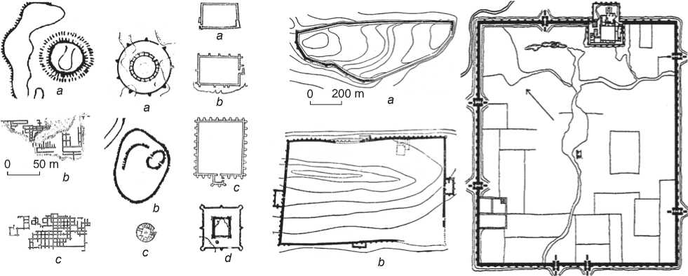
Fig. 3 . Layouts of settlements and residential areas in the period from the Late Bronze Age to the Middle Ages in Central Asia (ancient Khwarazm).
1 – early fortresses and residential areas of the Bronze Age: a – Ak-Tepe fortress, late 4th to second half of the 3rd millennium BC, b – residential area of Ayaz-Kala, late 3rd millennium BC, c – residential area of Dzhanbas-Kala, late 3rd millennium BC; 2 – late fortresses of the Iron Age and the Middle Ages: a – Koi-Krylgan-Kala, 6th–3rd centuries BC, b – Shash-Tepe, 6th–1st centuries BC, c – Deu-Kala, 12th– 13th centuries AD; 3 – fortified settlements with continuous housing pattern, 6th–3rd centuries BC: а – Kurgashin-Kala, b – Ata-Tyurk-Kala, c – Ayaz-Kala, d – Teshik-Kala; 4 – fortified settlements with habitable walls: a – Kyuzeli-Gyr, 6th–3rd centuries BC, b – Kalaly-Gyr-1, 6th–3rd centuries BC, c – Dzhanbas-Kala, 9th century BC to 1st century AD (image scale reduced 2x).
example, similar groups of dwellings existed in the countries of the East and in Sumer-Akkad in the 2nd millennium BC. However, the so-called southern type of dwellings, common in Babylonia, was most similar to ancient settlements with habitable walls of the northern type, known on the territory of the future Assyria, Kazakhstan, and the Urals. At the same time, settlements with the continuous building pattern began to appear. The Khwarazmian settlements with habitable walls were closed fortifications. Dwellings in several rows were placed along the walls. Fortifications simultaneously served as the walls of the outer row of dwellings. The internal free space was intended for communal cattle.
In their structure, the settlements with the continuous housing pattern cannot yet be called towns; they were only large houses located in random order, for which S.P. Tolstov used the term “complex of houses” (1948: 10). Further, they were united inside the fortress walls, forming groups-quarters typical of ancient towns. An architectural and planning basis for the “fortified settlements with habitable walls” was used in the formation of Central Asian towns of the ancient period for arrangement of the structure of fortress walls combined with dwellings.
The last structure that may serve as a parallel to the fortified settlements of the ancient Urals was the medieval fortress of Deu-Kala dated to the 12th–13th centuries AD. “It is a small round fort (51.5 m in diameter) surrounded by a powerful (up to 2 m thick) wall of huge (up to 96 × 53 cm, with a thickness of 16 cm) slabs of ashlar. A courtyard with a well was in the middle, surrounded by living quarters for a garrison made of stone. The location of Deu-Kala makes it possible to perceive it as the outpost of military expansion of the rising Khwarazm against the Central and Western Khorasan” (Ibid.: 21). That fortress reflects the functional typology of ancient fortified settlements, and can be juxtaposed with the structures of the Southern Urals under study, which are the same, but earlier than Deu-Kala. Possibly, these represent one of the earliest forms of garrison forts in Eurasia.
Thus, for the development of a working hypothesis, the location of the fortified settlements of the Petrovka-Sintashta culture must have definite boundaries and a vector of their territorial expansion. However, this is not yet confirmed, since the emergence of the structures was confined to the oecumene of the Ural northern steppe, with the exception of the Isinei fortified settlement, which is located more to the east, and the Alandskoye fortified settlement with individual barrows, located along the southern fringe of the Ural Mountains.
Scholars have observed that at the early stages of the town-planning culture of Central Asia, two types of volume-planning structure with circular and rectangular plan stand out, corresponding to two main architectural and planning techniques: the ring building pattern around an open courtyard, and continuous building pattern created by adjacent premises (typical of the ancient settlements of Kazakhstan).
The question of the continuity and echoes of the Sintashta building traditions in other cultures, in particular, those with developed statehood, still remains open at the present time.
Discussion
The fortified settlements of the Southern Urals can be discussed not only in terms of their belonging to a certain culture or ethnic group, but also to a specific developed civilization with a certain form of state system. By today, there is no agreement among scholars regarding the genesis of the Petrovka-Sintashta culture.
Discussing this issue, we cannot ignore the fact that one and a half millennia later, the Great Silk Road passed through the territory of the fortified settlements of the Southern Urals. A caravan or trade route could have passed through this territory much earlier, building up trade and exchange relations between the nomadic and sedentary tribes.
The agglomeration of fortified settlements demonstrates the presence of a certain territorial cluster or separate trading posts throughout the emerging “oasis of settlements”, from which bronze or products made of bronze may have been exported to Mesopotamia, Egypt, or the Indian lands. If we adhere to our working hypothesis, the territory of the fortified settlements of the Southern Urals functioned as a distant trading post of a certain society with a developed state system.
Based on the Central Asian typological parallels of the 1st millennium BC or later parallels of the 12th–13th centuries AD, which had morphological similarities with the fortified settlements of the Bronze Age in the Southern Urals, it can be assumed that the inhabitants of these settlements led a “garrison” way of life. The functional structure of fortified settlements in the Southern Urals, in fact, differed little from that of the Central Asian fortified settlements. At any time, people could stand up to defend their fortress or move farther inland. Such methods of placing fortifications on the terrain, in floodplains and bends of rivers, in a favorable defensive position, can only be compared to the garrison type of settlement, or purposeful creation of trading posts or oases, where people can gain a foothold for dozens and hundreds of years on a territory developed for the particular purposes of a society showing features of the state system. Such goals could have been both territorial and economic expansion, procurement of resources for the treasury of the state, and long-term military expeditions. This point can be supported by several historical and archaeological facts, for example, the presence of chariot remains in the burials of the 17th–16th centuries BC at the Sintashta cemeteries and in the mound complex of the fortified settlement of Olgino (Kamenny Ambar). The average age of the persons buried in these graves was 35–45 years. Unfortunately, little is known about the causes of their death, and information is insufficient for making any definitive conclusions. Research in this direction is just beginning (Zdanovich G., Zdanovich D., 2010).
Owing to the isolation from civilization, in field conditions, chariot driving could have not fully develop as an institution for training organized troops. Chariots and harnesses were not produced in large quantities in the Southern Urals, but were probably imported, which can describe the phenomenon of chariots in this territory as “foreign”. The remains of chariots or harnesses, with rare exceptions (bone psalia, wheel imprints in the soil of burial chambers: Sintashta cemetery, graves 28–30 (Gening V.F., Zdanovich, Gening V.V., 1992: 200–219), cemeteries near the village of Berlik (Zdanovich, 1988: 71–78)), have not yet been found.
According to archaeological atlases, the territory of the Southern Urals and Kazakhstan since the Neolithic period has been evenly settled along the rivers. By the 16th century BC, the traditions of construction underwent significant changes, but settlements continued to be formed regardless of the developmental stages of the Sintashta fortifications. In some cases, the sites of ruined fortified settlements (for example, Kizilskoye on the Ural River) were used for the Alakul and Fedorovka settlements in the 14th– 13th centuries BC (Zdanovich et al., 2003: 20–22).
Conclusions
The study of typology and genesis of fortified settlements of the Bronze Age in the Southern Urals have yielded definite scholarly results. The analysis of planning parallels has made it possible to identify typological and morphological similarities of
Example of comparative analysis of settlement layouts
Designation Name, type, planning on Fig. 1 structure
Aerial survey or magnetic measurements
Plan deciphering
Morphology of the plan in the unified scale


|
16 0 |
Kizilskoye, type 1, oval, with habitable walls, single-layered |
|
21 0 |
Bersuat, type 1, oval, with habitable walls, single-layered |
|
20 0 |
Andreevskoye, type 3/3, rectangle, with habitable walls, multilayered |
|
8 |
Kuisak, type 1/2/3, mixed, with habitable walls, multilayered |
Arkaim, type 2, circle, with habitable walls, single-layered
Sarym-Sakly, type 2, circle, with habitable walls, single-layered
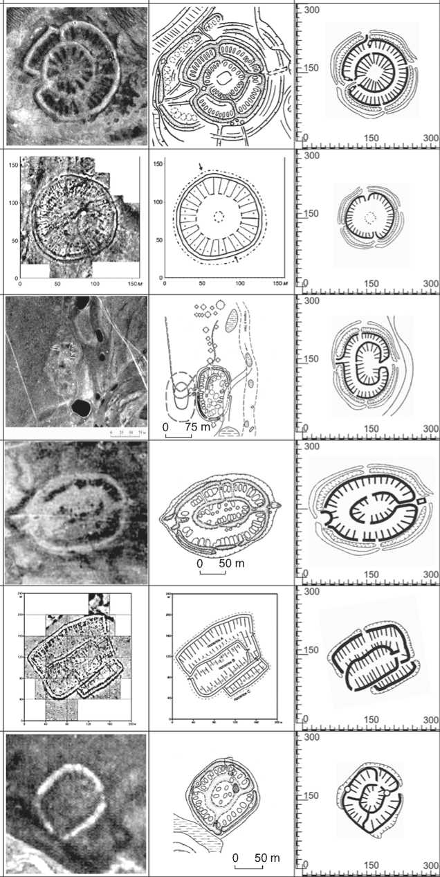
0 50 m
0 50 m
0 75 m
|
—----- |
structures and continuity of building traditions in the territories with developed statehood. The typology of fortified settlements of the Bronze Age in the Southern Urals has been largely determined and substantiated by the method of comparative historical analysis; it is directly related to fortifications with residential and production-artisan function. Such facilities were typical of remote trading posts with a garrison form of human settlement.
A graphical comparative analysis of the planning structures substantially supplemented the methodology for studying fortified settlements of the Bronze Age in the Southern Urals and brought the comparative method to a new level (see Table ). The similarity between the plans of these features and planning parallels from other cultures in terms of structure, shape, size, and organization techniques (see Fig. 2, 3) has been clearly demonstrated.
The results of this work make it possible to speak about the genesis of the Sintashta-Petrovka townforming fortification system and its hereditary and successive interrelations with ancient architectural and town-planning traditions of Central Asia in the early stages of formation of the Indo-European states. This study has contributed to the promotion and improvement of historical and architectural science in the field of historical reconstruction of archaeological features and comparative-historical analysis of monuments of ancient architecture and urban planning.
