A Neanderthal refugium in the Eastern Adriatic

Author: Vishnevskiy A.V., Pavlenok K.K., Kozlikin M.B., Ulyanov V.A., Derevianko A.P., Shunkov M.V.
Journal: Archaeology, Ethnology & Anthropology of Eurasia @journal-aeae-en
Section: Paleoenvironment, the stone age
Article in issue: 4 т.47, 2019.
Free access
Short address: https://sciup.org/145145458
IDR: 145145458 | DOI: 10.17746/1563-0110.2019.47.4.003-015
Text of the article A Neanderthal refugium in the Eastern Adriatic
The results of recent dating of complexes belonging to the Middle to Upper Paleolithic transition suggest non-simultaneous disappearance of Neanderthals in various regions of Europe (Higham et al., 2014). Anatomically modern humans, judging by the earliest evidence of their occurrence in these regions, probably co-existed with Neanderthals over a span of 2.6–5.4 thousand years.
The eastern Adriatic is one of the key regions for study of the Middle to Upper Paleolithic transition process in Southeastern Europe. On the basis of findings at Crvena Stijena in Montenegro, the disappearance of Neanderthals from that region was traditionally attributed to the Campanian Ignimbrite eruption ~40 ka BP (Fedele et al., 2008; Mussi, 2001; Morley, Woodward, 2011; Zilhao, 2006). The most ancient traces of anatomically modern humans in the eastern Adriatic, recorded at Šandalja II in Istria, show a calibrated date of ~32 cal BP (Karavanic, Smith, 2013). Thus, the time gap between the episodes of Neanderthal and modern human populations occurrence in the region could be more than 8 thousand years. Since no transitional complexes have been found in the area from southern Greece (the Kleisoura-1 site on the Peloponnesian Peninsula) to northern Croatia (the Fumane site) (Dogandzic, McPherron, Mihailovic D., 2014), and none of the known Middle Paleolithic industries shows features suggesting maturation of the Upper Paleolithic traditions on the local basis, most probably, the hominins with the Upper Paleolithic industry penetrated this region several thousand years after the Neanderthal population had left it.
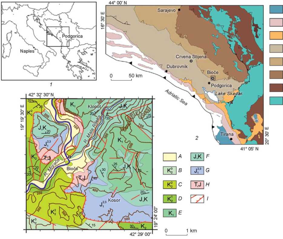
Comprehensive studies at Bioce in the central part of Montenegro, conducted by a Russian-Montenegrin expedition in 2010–2015 (Derevianko et al., 2017; Pavlenok et al., 2017), provided a new look on the cultural and population dynamics at the turn of the Middle and Upper Paleolithic in the region. The site is located under a rock shelter, at the foot of a massive limestone block, at an elevation of about 40 m above the river edge, at the confluence of the Moraca and Mala Rijeka rivers, 20 km upstream from the Podgorica city (Fig. 1,2). The Moraca valley in the neighborhood of the cave has steep shoulders, upright in places. The valley is 350 m wide and 70 m deep, the valley bottom is 250 m wide. The present-day Moraca river bed cuts through the valley bottom to a depth of 35 m, thus forming a canyon 30–40 m wide.
In terms of geology, the central Montenegro area belongs to the folded zone of External Dinarides, which is a complex scaly-overlapped structure (Osnovna Geoloska Karta…, 1971). This structure is formed on the continental base owing to southwestern thrust of tectonic plates being carbonate shelf fragments of predominantly Triassic-Cretaceous age. Northeastwards, in the Durmitor block and Internal Dinarides, oceanic crust fragments with numerous ultrabasite massifs, formed by ophiolitic association rocks, are widely developed. The Bioce site is located in the zone of Pre-Karst block thrust over the High Karst block; both are the main structural units of the External Dinarides (see Fig. 1). Both blocks are dominated by limestones, dolomitic limestones and dolomites, including those with flints and interlayers of slated clay rocks and marls. Carbonate rocks, composed mainly of calcite, dolomite, quartz, and argillaceous minerals, are predominantly developed in the neighborhood of the Bioce rock shelter and upstream from the Moraca and Mala Rijeka rivers.
In the stratigraphic sequence of the site, whose thickness is more than 5 m, four main lithological strata have been identified (Fig. 3) (Derevianko et al., 2015).
Deposits of stratum 1 include four weakly-differentiable sediment generations (1.1–1.4), formed by medium and light sandy and grussy loams of reddish-brown or dark-brown color. In the middle portion of the stratum, reference level 1.3 in the form of ocher-yellow sandy loam up to 10 cm thick stands out. Stratigraphic units of stratum 1 are saturated by humus, and also rock-debris, to various extents. The projective area of the latter is 30–50 % on the average. According to the results of experimental radiocarbon dating of coal and humus samples, accumulation of stratum 1 deposits proceeded from 32 to 40 ka BP (Derevianko et al., 2017; Pavlenok et al., 2017).
Within stratum 2, three stratigraphic units (2.1–2.3) have been identified. The upper and middle portions of deposits consist of gray-colored sandy loams and uneven-grained gray and gray-brown sands; the lower portion is composed of light loams abundantly saturated with fine rubble-crushed stony material (up to 40–50 % of the projective area). All units of the stratum are characterized by the development of carbonate cementation in the form of foci or horizons up to the state of breccia.
Lithological stratum 3 is composed of heavy reddish-brown loams. The upper portion shows abundant inclusion of fractured grus and rubble, the lower portion shows inclusion of single blocks. Genetically, these deposits are sediments of stratum 4, which experienced intense destruction in subaerial conditions under the influence of external environment agents.
Deposits of stratum 4 consist of two sediment varieties, formed by heavy reddish-brown loams. Its upper portion (horizon 4.1) shows inclusions of medium and large rubbles, lying in the form of nestlike accumulations. In the lower portion of stratum (horizon 4.2), lying on the rock base, detrital material consists of fragments of ultimately weathered intracave dripstone crusts and limestone concretions.
а b c d e f g h
Fig. 1. Schematic map showing location of the Bioce site ( 1 ), tectonic map (Schmid et al., 2016) ( 2 ), a fragment of the geological map of the southern part of the Dinar highlands on a scale of 1:100,000 (Osnovna Geoloska Karta…, 1971) ( 3 ). a – Ionian zone; b – Dalmatian zone; c – Budva-Cukali zone; d – High Karst; e – Pre-Karst; f – Eastern Bosnia-Durmitor; g – Drina-Ivanjica; h – ophiolitic zone of Central Dinarides. A – Holocene-Pleistocene sediments; B – grayish-white limestones, dolomitic limestones, and dolomites (the Cenonian Superstage); C – dolomites, dolomitic limestones, and limestones (the Turonian Stage); D – bitumen limestones, dolomitic limestones, and dolomites (the Cenomanian Stage); E – limestones, marly limestones, dolomitic limestones, and dolomites; F – reef, massive, and laminated limestones; G – limestones, clay shales, and slated marls; H – dolomitic limestones, calcareous dolomites, recrystallized limestones with flints; I – tectonic deformations.
In stratum 4, no archaeological materials have been discovered.
Lithic industry of stratum 3 is characterized by the use of parallel, orthogonal, or centripetal flaking, rare use of the Levallois technique, and by predominance of longitudinal simple and double-edged side-scrapers. In terms of the main technical and typological indicators, this industry is the closest to the materials of strata XXII–XVIII of the Crvena Stijena site, which were earlier dated to the MIS 5 time; however currently, strata XXII–XX are attributed to the turn of MIS 5 and MIS 4, while stratum XVIII is associated with MIS 3 (Mihailovic D., Mihailovic B., Whallon, 2017).
In the materials of stratum 2, along with the features relating to the industry of the underlying layer, there were signs of mass detachment of blades and production of elongate points, side-scrapers, and atypical knives on their basis. In its appearance, this industry is mostly similar to that of stratum XVII of Crvena Stijena, earlier dated to substage MIS 5а, and later assigned to MIS 3 (Ibid.).
Lithological stratum 1 contains materials of several habitation episodes, including the Mousterian industry of Charantian type or (according to the regional scale of the Middle Paleolithic) micro-Mousterian facies, which is characterized mainly by radial and orthogonal cores,
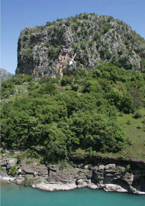
Fig. 2. General view of the Bioce rock shelter.
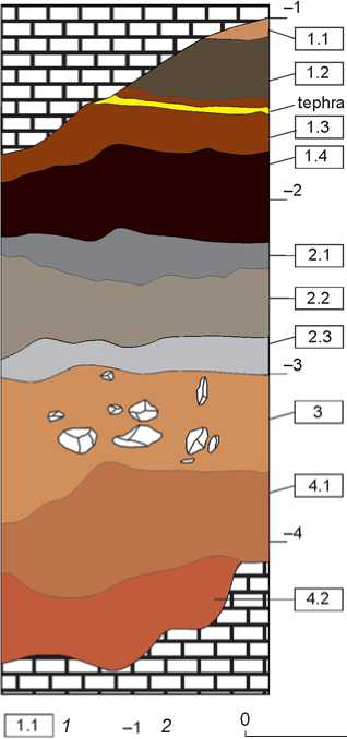
Fig. 3. Structure of the section of Pleistocene deposits at Bioce .
1 – layer number; 2 – bench mark.
1 m
small flakes, scaly retouch, microshapes of longitudinal and transverse side-scrapers, as well as those of atypical end-scrapers. The age of such industries in the eastern Adriatic corresponds to the second half of MIS 3, which is consistent with radiocarbon dates of deposits of stratum 1 at Bioce.
Of special interest in the structure of Bioce deposits are tephra remains lying in the middle portion of the reddish-brown light loams of lithological stratum 1 in the form of ocher-yellow sandy loam 8–10 cm thick (reference level 1.3). The loam is weakly sanded (with separate incompetent inclusions of fine grus-rock or gritty size), homogeneous in composition, loose, porous, with a coarsely nut or fine-grained structure. Inversion (overturning) of horizon during mixing with deposits of the host sequence is observed in places, which is typical for fast defluction-solifluction processes.
This horizon of volcanic deposits is apparently related to the Campanian Ignimbrite eruption, one of the largest volcanic events of the Late Pleistocene and the largest one in Europe over the last 100 thousand years. Numerous studies that have determined that the volcanic center was located west of Naples, in the area of the Phlegraean Fields, associate this event with the formation of the Campi Flegrei caldera ~12 km in diameter (Scarpati et al., 2013). The eruption was accompanied by the spewing of a great amount of solid substances (from 49 to 300 km3 by various estimates) (Civetta et al., 1997; Costa et al., 2012; Scarpati, Sparice, Perrotta, 2014; Fedele et al., 2016; Marti et al., 2016), formation of a thick series of deposits close to the crater, composing the so-called Breccia Museo (Civetta et al., 1997; Fedele et al., 2008; Pappalardo, Ottolini, Mastrolorenzo, 2008), and numerous radial pyroclastic currents, which spread to a distance up to 80 km (Fisher et al., 1993). These currents formed the main volume of eruption material in the Campanian area—volcaniclastic breccias, ignimbrites, and tuffs (Fedele et al., 2008, 2016). The deposits are sufficiently well studied; detailed isotopic, mineralogical, geochemical, and petrological analyses have provided for the construction of consistent models of magma-chamber evolution (Fulignati et al., 2004; Fedele et al., 2008, 2016; and others).
Furthermore, up to 100 km3 of eruptive column solid material (Costa et al., 2012; Marti et al., 2016) ~40–45 km high, which was formed during the caldera collapse, were spread by stratospheric flows (predominantly in the east-northeastern direction) to a distance of more than 2 thousand km, and over an area of 2 to 5 mln km2 (Costa et al., 2012; Smith et al., 2016; Marti et al., 2016). This material formed a widespread tephra layer known as Y-5 or C-13, which serves as a reliable marker in correlation of Mediterranean marine and terrestrial deposits. The last data and models built taking into account variations of composition and distribution of size of glass shards (Smith et al., 2016; Marti et al., 2016) from the distal facies of eruption reveal a more complex propagation of particles of the Plinian and syn-Ignimbrite eruption stages than previously thought (Costa et al., 2012), and explain the reason for anomalously high thickness of tephras in some sections of southeastern Romania (at a distance of more than 1200 km from the volcanic center) (Veres et al., 2013), and at the sites of the Kostenki-Borschevo region (Giaccio et al., 2008).
The age of the main phase of Campanian eruption, which yielded the major part of distal facies materials, is estimated by the 39Ar/40Ar isotope method (according to sanidine crystals from proximal and medial facies) as 39.30–39.85 ka BP (Fedele et al., 2008; Giaccio et al., 2017). This definition correlates with the global freezing epoch—the Heinrich event 4 (HE-4), with the Lachamp-Kargopolovo paleomagnetic excursion (Giaccio et al., 2008), the Antarctic Isotope Maximum AIM-8 (Buiron et al., 2012), and Greenland Stadial GS-9 (the beginning 40,121 ka BP, the plateau 39,372 ka BP according to the study of isotopic signature of methane in ice cores) (Guillevic et al., 2014).
Many researchers are of opinion that the Campanian eruption determined the direction of cultural and population development of the last Neanderthals and the first anatomically modern humans in Europe (Fedele et al., 2008; Mussi, 2001; Zilhao, 2006). At a number of multi-stratified sites in Italy, Central and Eastern Europe, tephra layer marks the boundary between cultural layers of the Middle and Initial Upper Paleolithic on the one side and the Aurignacian industries on the other side (Fedele et al., 2008; Hoffecker et al., 2008; Jöris, Street, 2008). On the Balkan Peninsula, it is recorded in the stratigraphic sequence of Crvena Stijena (Morley, Woodward, 2011), Temnata in Bulgaria, and Franchthi in Greece (Morley,
2007). However, if to the east of Balkan range there are known symbiotic transitional industries that can be considered as evidence of cultural contacts between Neanderthals and anatomically modern humans 40–35 ka BP (for example, Temnata and Bacho Kiro in Bulgaria), then to the west of it, there is no such evidence.
The basic argument in favor of disappearance of Neanderthals in the eastern Adriatic as a result of Campanian eruption is a thick horizon of volcanic ash in stratum XI of Crvena Stijena, classified as tephra Y-5 (Morley, Woodward, 2011). The ash horizon is underlain by deposits of stratum XII, for which a radiocarbon date 40,777 ± 900 BP is available (Mihailovic D., Mihailovic B., Whallon, 2017), with a Middle Paleolithic industry characterized by researchers as Late Mousterian (Basler, 1975), micro-Mousterian (Brodar, 1965), typical Mousterian (Ivanova, 1979), or Mousterian Charantian-like (Kozlowski, 1992). Deposits of stratum X overlying a tephra layer contain remains of a developed Upper Paleolithic industry (Basler, 1975). The represented data, as well as a relative closeness of the eastern Adriatic to the place of eruption, suggest that degradation of vegetation and fauna with subsequent extinction of the Neanderthal population took place in this region, like on the Apennine Peninsula (Mussi, 2001; Zilhao, 2006). Such pattern is consistent with the materials from Mujina Pecina in Croatia, where micro-Mousterian layers obtained AMS- and ESR-dates within 45–39 ka BP (Rink et al., 2002).
Methods and results of the tephra layer study
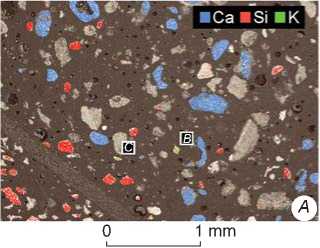
To study the mineral composition of tephra layer at Bioce, a single averaged sample was selected uniformly throughout the thickness, samples of deposits 10–15 cm below and above the tephra layer were taken, and a sample from the humic interlayer 1.2, which lay 0.5 m above the tephra (Fig. 3). Samples weighing 300– 500 g were divided into coarse (> 0.5 mm) and fine (< 0.5 mm) fractions. Coarse fraction composition was classified into several types of debris, whose fragments were assembled into epoxy resin blocks 25 mm in diameter for subsequent study by optical and electron microscopy methods. The same preparations were made from fine fraction weighed quantities. To this end, samples were preliminarily purified from the carbonate component using 5 % hydrochloric acid solution for 1 minute, then non-dissolved residue was carefully washed and dried out. Next, a weighed quantity was mixed with resin, solidifier was added, and the mixture was poured into an aluminum ring. After solidification of resin, the preparations were ground and polished on fat-based diamond pastes.
X-ray phase analysis of a sample from the tephra layer, purified from the carbonate component, was conducted in the Laboratory of Cenozoic Geology, Paleoclimatology and Mineralogical Indicators of Climate, the Sobolev Institute of Geology and Mineralogy SB RAS, on the X-ray powder diffractometer DRON-4 (radiation СuKα, a graphite monochromator). The diffraction patterns were scanned in the 2θ interval from 3 to 65°, with a step of 0.05°, the scanning time at a point is 4 s, the slit is 0.5 mm.
The polished samples were studied using the Carl Zeiss Axio Scope A1 microscope in reflected light. The mineral composition, details of mineral aggregate structures, and special features of mineral chemical mechanism were studied on the Tescan Mira 3 scanning electron microscope (SEM) equipped with the energy-dispersive spectrometer Oxford X-Max 80 at the Center for Collective Use of Scientific Equipment for Multi-element and Isotopic Studies of the SB RAS, the Sobolev Institute of Geology and Mineralogy SB RAS. Spectrum survey parameters: accelerating voltage is 20 kV, electron beam current is 1 nA, spectrum collection time is 30 s. Subsequent processing of energy-dispersive spectra was conducted in the automatic mode, using the INCA Energy software. The composition of minerals per minals was recalculated following the standard procedure, using the MS Excel software.
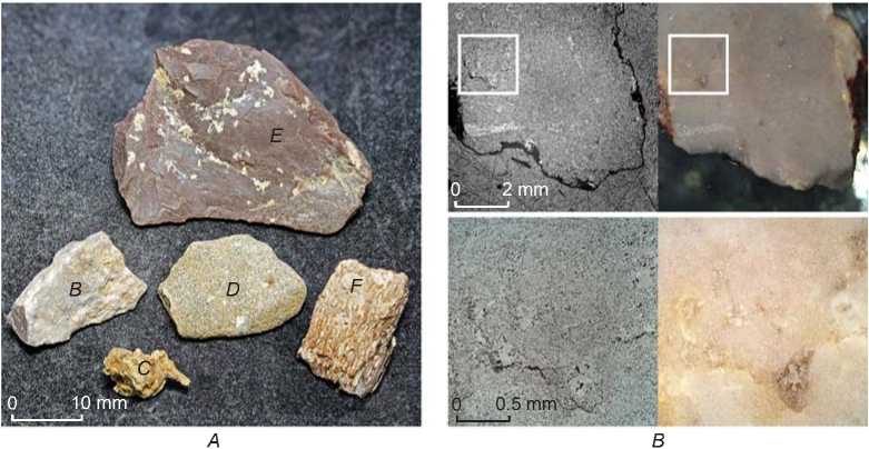
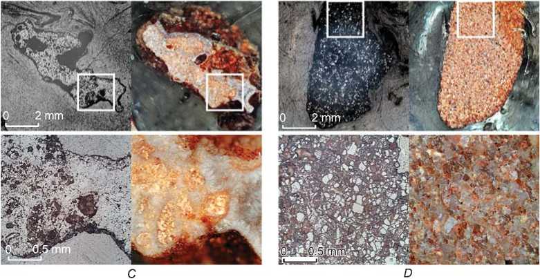
Coarse fraction. The composition of coarse fraction (Fig. 4, A) is dominated by limestone debris corresponding to material of the rock shelter vault (Fig. 4, B). Fragments of intra-cave dripstone carbonate neoformations are also widespread (Fig. 4, C). The second most frequent variety of debris consists of bone fragments in good state of preservation, often charred, which are the remains of economic activities of early inhabitants of the site. Fragments of wax flints that served as raw materials for manufacture of stone tools are also widespread (Fig. 4, E). These raw materials probably originated from the Upper Triassic-Early Jurassic rocks, which included flint horizons, according to geological map (Fig. 1). Fragments of siltstones and fined-grained sandstones pertain to rare materials in coarse fraction (Fig. 4, D). These are obviously the materials from the Early Jurassic sedimentary formations widespread upstream the Morača River. These rocks were also used by humans to manufacture tools.
Fine fraction. Macroscopically fine fraction is a light-colored brownish-yellow, with a gray tint, granular aggregate of sandy-siltstone size. The grains are dominated by tubular and irregular carbonate aggregates, bone fragments, and flint splinters; more rarely, by rounded grains of colorless or yellowish quartz. The yellowish thin-scaled (coarse silt to fine sand) aggregate, at ×200 magnification, shows separate colorless rounded grains of quartz (more rarely, of feldspar), fragments of bone tissue, yellowish limestones, and brownish flints. Noteworthy is the absence of glass particles (shards) of specific laminar, tubular, or Y-like shapes, which are typical of ash deposits. This fact, as well as the presence of well-preserved shards and pumice particles with typical elongate bubbles in the tephra layers of Temnata (Giaccio et al., 2008) and Crvena Stijena (Morley, Woodward, 2011) caves, which correspond to the Campanian event, raised a doubt in the volcanic origin of this horizon. In addition, estimation of the bulk composition by the X-ray fluorescence method has shown the content of P2O5 up to 10 wt%, Na2O 0.4 wt%, K2O 0.5 wt%, while typical Campanian tuffs are characterized by the content of phosphorus by an order less, and a considerably greater content of alkalis (Civetta et al., 1997; Fedele et al., 2016).
X-ray phase analysis of a fine fraction sample treated with HCl solution has demonstrated the presence of large amount of chlorite ((Al,Fe,Mg)6[(Si,Al)4O10] (OH) 8 ) and irregular illite ((K 0.6–0.85 Al 2 [(Si,Al) 4 O 10 ] (OH) 2 ). Quartz (SiO 2 ), K-feldspar ((K,Na)[AlSi 3 O 8 ]), and possibly goyazite (SrAl3(PO4)(PO3OH)(OH)6) are present in smaller quantities.
Chlorites and illite belong to clay minerals and are among the most abundant soil components of various types. Their formation is typical of such surface processes as the building of weathering-crust caused by the destruction of primary (high-temperature— magmatic and metamorphic) rock minerals, and the hydration of silicate volcanic glasses.
Obviously, quartz grains from the fine fraction consist mainly of siltstones and sandstone particles that are a result of the disintegration of erogenous rocks and eolian transfer of materials, while the substantially smaller part of them consists of splinters of flint brought by humans. K-feldspar, peculiar to many magmatic and metamorphic rocks, does not belong to typical soil minerals: under conditions of warm climate and sufficient moistening, it is gradually replaced by clay minerals, predominantly illite and kaolinite.
EF
Fig. 4. Main types of fragments in the large fraction from the Bioce tephra layer.
A – general view of typical fragments; B – fine-grained pale limestone with recrystallization areas; C – carbonaceous fragment of irregular shape—a secondary calcareous crust with cockade-like structure; D – fine-grained quartz sandstone with clay-carbonaceous cement; E – wax flint with globular structure; F – charred bone fragment.
Thus, the presence of a large amount of K-feldspar grains in the sedimentary carbonate formations is not quite typical. The peaks in the X-ray photograph presumably corresponding to goyazite were not confirmed during further study with the use of electron microscopy.
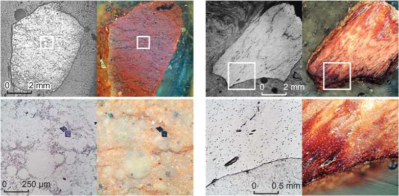
Feldspars. Special attention should be paid to numerous K-feldspar grains discovered in the tephra layer. The grain-size varies from 20 to 470 μm. Fig. 5, A shows elemental areal mapping data laid over the image obtained by SEM. Thus, quartz particles containing a large amount of silicon are tinted with highly-saturated red color, bone fragments rich in calcium are tinted blue, and K-feldspar grains are tinted red and green. These grains are individualized, do not contain mineral or glassy inclusions, and are not in intergrowth with other minerals. Typical features are angular, often weakly elongated shapes, and the presence of reentrant angles (Fig. 5, B–F), including crescentic shapes (Fig. 5, D, F), which are actually not encountered in case of transportation by water or wind. The studied grains are dominated by those rather homogeneous in composition, where variations of main components in the grain are not more than 3–5 mol% of the corresponding minal. The majority of compositions form a compact group with the content of orthoclase minal (KAlSi3O8) of 51–69 mol% and a small admixture of CaO (0.5–0.7 wt%), which corresponds
0 10 0 μm
0 10 0 μm
0 8 0 μm
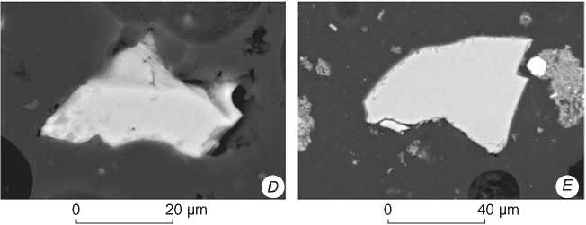
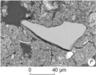
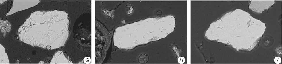
Fig. 5. Back-scattered electron images of a polished samples from the fine fraction of the tephra layer ( A – F ), grains of high-K-feldspars (orthoclase or microcline) of typical (medium- or well-rounded) shape ( G – I ).
A – general view of polished surface with overlaying of results obtained in the element-mapping mode: blue (saturated) color – Ca – bone fragments, red (saturated) color – Si – quartz grains, green color (saturated green touched with red) – K – K-feldspars, bright white grains – Fe oxides and hydroxides, light-gray – clay silicates (chlorite and illite), dark-gray – epoxy resin; B – F – fragments of sanidine crystals with typical acute-angled shapes; G – from the tephra layer; H – from the layer 10–15 cm below the tephra; I – from the layer 10–15 cm above the tephra.
to 2–3 mol% of anorthite minal (CaAl2Si2O8). The points of compositions with a higher content of Na2O correspond either to certain areas of zoned crystals or to separate grains. However, it should be considered that all of them are just fragments of larger crystals. Moreover, these grains are also characterized by a relatively high content of calcium (4–6 mol% of An), which allows the studied grains to be assigned to sanidine—a high-temperature modification of K-feldspar with an intermediate composition between albite and orthoclase, with predomination of the latter. Such compositions are typical of fast-crystallizing magmatic effusive rocks.
One of the groups of feldspar grains stands out from the common trend in terms of composition: it shows a very high content of Or minal, which implies a mineral structure corresponding to orthoclase or microcline. Such compositions are typical of feldspars formed in a wide variety of settings: from authigenic (sedimentary) and hydrothermal to metamorphic and intrusive magmatic. Judging by the images obtained by SEM, the surfaces of these grains are very different from those of sanidine in the presence of shagreen and great quantities of microcracks. The shape of the grains ranges from isometric to elongate, with an aspect ratio of up to 1:3. Their size varies from 20 to 165 μm along the long axis. Unlike sanidine, reentrant angles are not typical of them, and they are well rounded (Fig. 5, G ). It can be assumed that these grains got into the tephra layer either as a result of eolian transfer, or from a secondary collector—siltstones or fined-grained sandstones, whose fragments have also been discovered.
Apart from sanidine and high-K-feldspar, a grain of Na-Ca feldspar (plagioclase, whose composition is consistent with andesine) has been discovered in the tephra layer.
In addition, grains of K-feldspars have been found in the over- and underlying layers. In the underlying layer, two grains have been identified. They are identical to high-K-feldspars in their composition, morphology, and size (Fig. 5, H ). In the overlying layer, apart from high-K-feldspars (Fig. 5, I ), three sanidine grains similar to grains from the tephra layer have been found.
The sizes of the feldspar grains were estimated on the basis of 300 grains. 25 grains studied by SEM, and 275 grains visually identified as feldspar grains, according to the degree of transparency, cleavage, and angular shape, were counted. The size was estimated along the long axis under a binocular microscope at ×40 magnification. Generally, the sample is characterized by unimodal distribution, where 71 % of grains are in the range of 90–250 μm (ϕ=3.5–2.0). The distribution is asymmetrical; a shoulder towards smaller grains stands out: about 16 % of the grains are concentrated in the range of ϕ 4.5–3.5 (44–90 μm). Grains larger than 400 μm are single.
Other characteristic minerals. Apart from feldspars, the composition of clinopyroxenes has been also analyzed. In the sample from the tephra layer, they are represented by small (usually less than 100 μm) lightgreen translucent crystals and fragments. The main composition group of clinopyroxenes from Bioče, in terms of minals (enstatite (En, MgSiO3), wollastonite (Wo, CaSiO3), and ferrosilite (Fs, FeSiO3)) in mol% corresponds to augite having the composition of En36–39Wo47–49Fs13–16 with 1.6–5.0, and 0.5–1.4 wt% of Al2O3 and TiO2, respectively. One grain tends towards the diopside composition (En47Wo44Fs9); besides, it is characterized by a low content of TiO2 (0.3 wt%) and a considerable amount of Cr2O3 (0.6 wt%). Three non-titaniferous grains of more ferruginous and low-alumina (0.5–0.8 wt% of Al2O3) clinopyroxenes are observed, whose composition can be expressed through the MgSiO3 triangle (enstatite minal, En)—FeSiO3 (ferrosilite minal, Fs) = CaSiO3 (wollastonite minal Wol): En 27–34 Wo 47–49 Fs 16–25 .
Also, in the sample from Bioče, grains of moderately titaniferous hornblende, Al-rich chrome spinel, and clay minerals with an increased magnesium content have been found, which indicates a contribution of ophiolitic source to the formation of deposits. The presence of these minerals is explained by the relative closeness of the site to the outcrops of ophiolitic crustal blocks in the central part of the Dinar highlands (see Fig. 1), whose fragments also occur in the Durmitor block.
Discussion
Comparison of sanidine and clinopyroxene grain compositions. Phenocrysts of sanidine, more rarely those of clinopyroxene, plagioclase, and darkcolored minerals, which cumulatively comprise up to 3–6 vol% of the rock, are commonly observed in the scoria deposits and trachyte-phonolitic lithoclasts from the proximal and medial facies of the Campanian eruption (Scarpati, Sparice, Perrotta, 2014). Sanidine forms rather large crystals—up to 4–5 mm along the long axis, its composition varies greatly depending on the eruption phase, and even on a separate impulse (Pappalardo, Ottolini, Mastrolorenzo, 2008; Fedele et al., 2008; 2016). Such large crystals cannot be transferred over long distances; therefore they are widespread only in the deposits of the Campanian Plain and its immediate surroundings. At the same time, smaller crystals and their fragments can be transferred over large distances; they are even observed in the most distant locations of tephra—on the Russian Plain (Giaccio et al., 2008).
According to comparison of the composition-point distribution of studied sanidine grains from the Bioce tephra layer to the data of the temperature dependence of mineral formation in the albite-anorthite-orthoclase ternary system (Ribbe, 1983) (Fig. 6), the majority of studied sanidine grains from Bioce (apart from high-potassium compositions) were formed at temperatures of 700–900 °C, with subsequent fast cooling, and did not transform into orthoclase-albite aggregate, which is typical of intrusive magmatic rocks and forming in the same range of compositions during slow cooling. Obviously, these grains appeared as a result of volcanic events that were contemporary with the accumulation time of this horizon, or destruction and eolian scattering of more ancient alkaline volcanic rocks relatively close to Bioce. Since it has been impossible to find information about the chemical composition of sanidine from the distal facies of the Campanian eruption, the obtained results were compared to the available data on the proximal and medial facies (Pappalardo, Ottolini, Mastrolorenzo,
2008; Fedele et al., 2008; 2016). According to the petrological models, the melt composition changed regularly from differentiated to a more primitive one with a higher K/Na ratio (Fedele et al., 2016), which affected the composition, of not only produced rocks, but also minerals, including feldspars. The early and intermediate stages of eruption (near (proximal) and distant from the eruption center (medial) facies) are characterized by rather high sodium sanidine Or61–66 containing an An component equal to 3–5 mol%; and for the late stage, Or77–85 compositions and 2–3 mol% of the An component (Fig. 6).
Grains from Bioce, which are sanidines in their composition, correspond to the early stages of intermediate eruption phases, and are closest to the lower part of the Welded Grey Ignimbrite (WGI) facie, which prevails in volume among the Campanian Plain deposits pertaining to this eruption.
The composition of studied clinopyroxene grains is also in good agreement with the data obtained from proximal and medial deposits (Fedele et al., 2016). The grain En47Wo44Fs 9 from the Bioce sample can be compared to the high-magnesia clinopyroxene En43–47Wo46–48Fs6–10, similar to diopside, for which xenogenic origin is implied. The main group of clinopyroxene compositions from the Campanian Plain deposits En32–39Wo47–49Fs13–20 is consistent with the range En36-39Wo47-49Fs13-16 of the Bioce site.
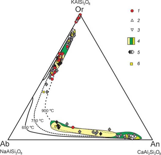
Fig. 6. Composition of feldspar grains from the Bioce tephra layer as compared to proximal (Breccia Museo) and medial pyroclastic deposits of the Campanian Ignimbrite eruption (Pappalardo, Ottolini, Mastrolorenzo, 2008; Fedele et al., 2008;
2016). Isotherms after (Ribbe, 1983).
1 - tephra layer at Bioce; 2 - 10-15 cm over the tephra layer at Bioce; 3 - 10-15 cm under the tephra layer at Bioce; 4 - Breccia Museo (Campi Flegrei), from differentiated to more primitive; 5 – medial tephras from the surroundings of Campanian plateau, from differentiated to more primitive; 6 – distal tephras from stratum XI of Crvena Stijena.
Comparison of grain size. Analysis of the size distribution of tephra particles is also an important method for determining the tephra’s source, geographical abundance of ashfalls relating to various stages of eruptions. Detailed studies of the sizes of glassy ash particles from horizon XI of Crvena Stijena were conducted by M. Morley and J. Woodward (2011).
Fragments of sanidine crystals from Bioce are 20100 цт in size, which generally corresponds to the expected size of ash particles [Ibid.] for this territory, taking into account that many of these grains could have been included in the glassy groundmass replaced by hydrous clay minerals as a result of hydration.
Thus, the composition of the studied grains clearly confirms the volcanic origin and alkali composition of the initial melts.
This fact, and also the characteristic shapes and sizes of fragments when comparing this layer to the regional stratigraphy, allow us to assign these volcanic products to Y-5 tephra.
Conclusions
In the habitation sequence of Bioce, the tephra layer lies inside lithological stratum 1, in stratigraphic unit 1.3. It has been established that artifacts from these deposits, as well as from the underlying (1.4) and overlying (1.2 and 1.1) ones, judging by the main technological and typological characteristics, belong to one and the same lithic industry—the micro-Mousterian facies of the local Middle Paleolithic. The cores of this industry are dominated by radial cores for the detachment of small flakes. Orthogonal shapes are typologically and quantitatively close to them. Longitudinal cores are the most abundant among the monofrontal singleplatform cores. Products of Levallois technology and narrow-face cores are observed. Flakes prevail among the spalls. Blade-blanks are rare. Microforms are most typical for the toolkit. The inventory is dominated by side-scrapers, most frequently longitudinal, more rarely transverse. Another mass group consists of atypical end-scrapers. Atypical knives form the third category in terms of quantity. Pointed and combination shapes are relatively scanty.
The materials from key eastern Adriatic sites with micro-Mousterian industries, such as Crvena Stijena (Mihailovic D., Mihailovic B., Whallon, 2017) and Mujina Pecina (Rink et al., 2002), until recently, in the absence of data on the age and type of Bioce tephra deposits (Buricic, 2006), were considered evidence of a large time-gap between the episodes of Neanderthal population and the occurrence of modern humans in the region. However, according to the results of recent studies of the upper part of the Bioce deposits, the Campanian Ignimbrite eruption apparently did not interrupt the development of the Neanderthal culture in the eastern Adriatic. Consequently, this territory could have been a Neanderthal refugium in Southeastern Europe. This version is supported by materials from the Velika Pecina cave in Dalmatia, where several Mousterian habitation levels were recorded, aged about 32–35 ka years (Karavanic et al., 2014).
Acknowledgement
This study was supported by the Russian Foundation for Basic Research (Project No. 18-09-40062).
