A ritual complex with deer stones at Uushigiin Uvur, Mongolia: composition and construction stages (based on the 2013 excavations)
")
Author: Kovalev A.A., Rukavishnikova I.V., Erdenebaatar D.
Journal: Archaeology, Ethnology & Anthropology of Eurasia @journal-aeae-en
Section: The metal ages and medieval period
Article in issue: 1 т.44, 2016.
Free access
Short address: https://sciup.org/145145253
IDR: 145145253 | DOI: 10.17746/1563-0110.2016.44.1.082-092
Text of the article A ritual complex with deer stones at Uushigiin Uvur, Mongolia: composition and construction stages (based on the 2013 excavations)
In 1970, a team of the Soviet-Mongolian Historical and Cultural Expedition headed by V.V. Volkov and E.A. Novgorodova examined a ritual complex at Uushigiin Uvur (Uushgiin Övör). The first publication of the site-plan and drawing of deer stones made during the survey (Volkov, Novgorodova, 1975) marked the start of a new stage in the research of the latter as a culture phenomenon of nomadic sites. On the basis of the similarity between weapons depicted on the deer stones at Uushigiin Uvur and weapons of the “Karasuk types”, Novgorodova and Volkov attributed the earliest deer stones to the Late Bronze Age (Novgorodova, 1973; Volkov, Novgorodova, 1975: 84; Volkov, 1981: 111; Novgorodova, 1989: 182–183, 211–212). The site-plan published in 1975, showing the deer stones arranged in a row directed southward from the mound (khereksur), was among the reasons for attributing them to a single culture (Hudiakov, 1987: 156–158; Novgorodova, 1989: 202).
In 1999–2006, the Mongolian-Japanese Expedition headed by D. Erdenebaatar, Shu Takahama, and Toshio
Hayashi, examined the site (Takahama Shu et al., 2006)*. A detailed topographic map of the site was made (Fig. 1). The expedition excavated one large khereksur (Kh-1) located to the north of the deer stones, a burial-mound with a circular enclosure to the east of the stones (Kh-12), and several other burial and ritual structures, including stone constructions concentrated in a small area near deer stones 4 and 7 (hereafter, deer stones 1–15, registered in 2013, are numbered as in Volkov’s and Novgorodova’s publication). New drawings of the previously discovered deer stones were made. A new stele discovered in the fringe of the khereksur and showing some of those attributes such as an “earring” and a beveled upper facet, supports, as the authors believe, the idea that those structures are contemporaneous with the deer stones (Ibid.: 77). In addition, four radiocarbon dates were obtained for animal-bones from the studied ritual structures accompanying the khereksur and deer stones. All the dates (after calibration) fall within the range of the 13th to 9th centuries BC (Takahama Shu, 2010: 127).
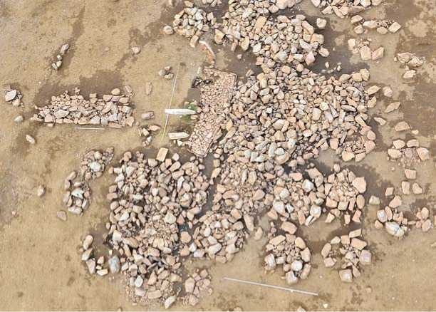
In 2013, the International Central-Asian Expedition headed by A.A. Kovalev and D. Erdenebaatar conducted large-scale excavations at Uushigiin Uvur (Fig. 2) in order to understand the spatial arrangement and construction-history of the ritual complex. During excavations, the central area of the so-called western row of the deer stones was examined.
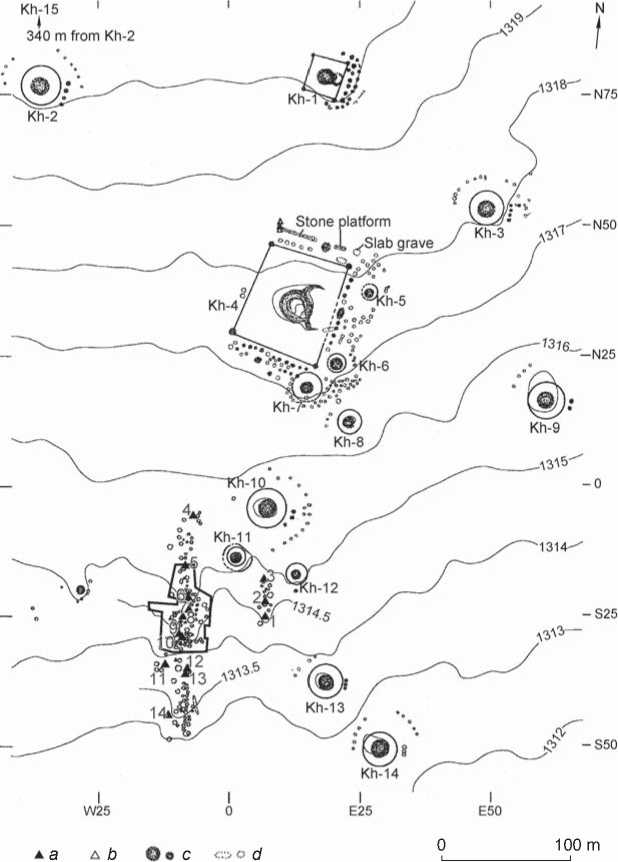
Fig. 1. Plan of Uushigiin Uvur (after (Takahama Shu et al., 2006)). Borders refer to the 2013 excavation.
a – deer stones (1–14, numeration after (Volkov, Novgorodova, 1975)); b – steles; c – stone mound; d – row of stones, stone ring. Kh – khereksur .
The excavation was arranged so as to encompass all the structures near Deer Stones 5 and 10 preserved in situ (their arrangement is shown in Fig. 1), not only the area of the highest concentration of the stone constructions. The maximum north-to-south and west-to-east widths of the excavated area are 75 m and 55 m respectively. The ground (humified loess sediments) was removed over the entire area to the level of rubble overlying virgin soil, to make sure that all the structures and items made at each stage of complex development will be identified. The scale of the drawings was 1 : 10 for maximum detail.
A significant problem for reconstructing the arrangement and history of the complex’s structure was caused by the barbarous activities of those who, in the 1980s or 1990s, had buried the fallen deer stones. Obviously, this was done without any preliminary survey aimed at identifying their original places. New pits could damage the original structures. An especially heavily damaged area was that where Deer Stones 6–8 had been situated initially (Volkov, 2002: 80–81). One can only guess at their original position (Volkov, 2002: 80–81).
The studied part of the complex included two ensembles with similar compositions that consist of the
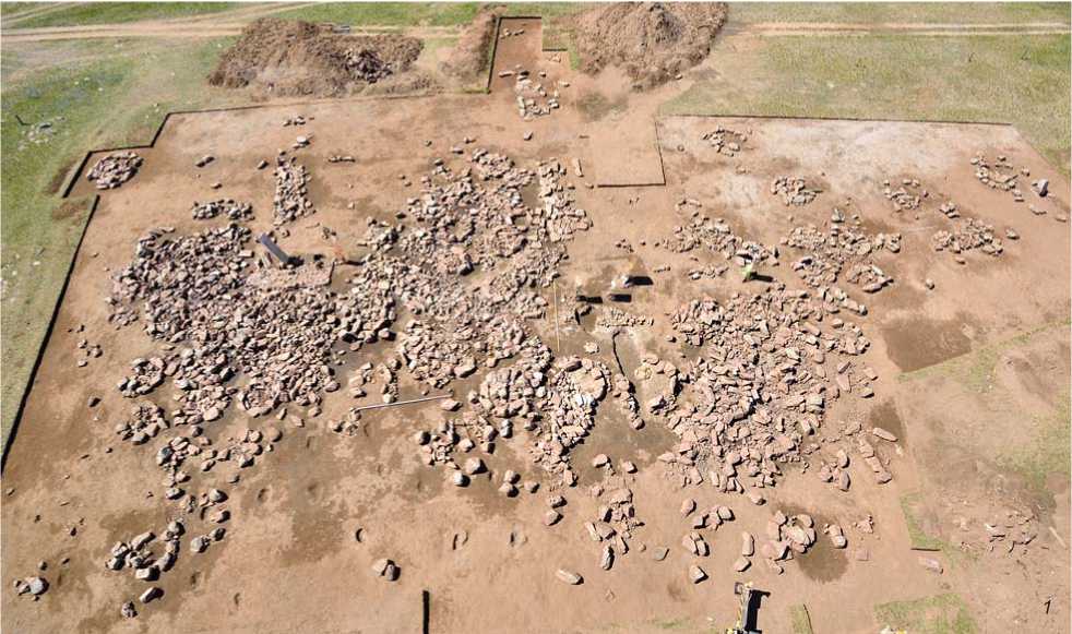
Fig. 2. The 2013 excavation at Uushigiin Uvur. General view from east ( 1 ) and south ( 2 ). Replaced deer stones are retouched.
structures with the deer stones (Fig. 3). Each ensemble rested on two stone platforms: one is curved, with its long axis oriented along the south-south-west to north-northeast line (Platforms 1 and 2); the other is rectangular
(Platforms 3 and 4), extended in the latitudinal direction and accompanied by three stone steles placed at its edges. In both cases, the deer stones were installed along the western edge of the curved platform.
Stele 18
Stele 17 Д
Stele 16
acomb'2
'it for DS f
Ir. 5^
Pit'for DS 7? (06pit 1 (06pit 2)
Pit for DS 8 A(C
Stele 4
Stele 19 д
Stele 20 Д
Stele 21 Л
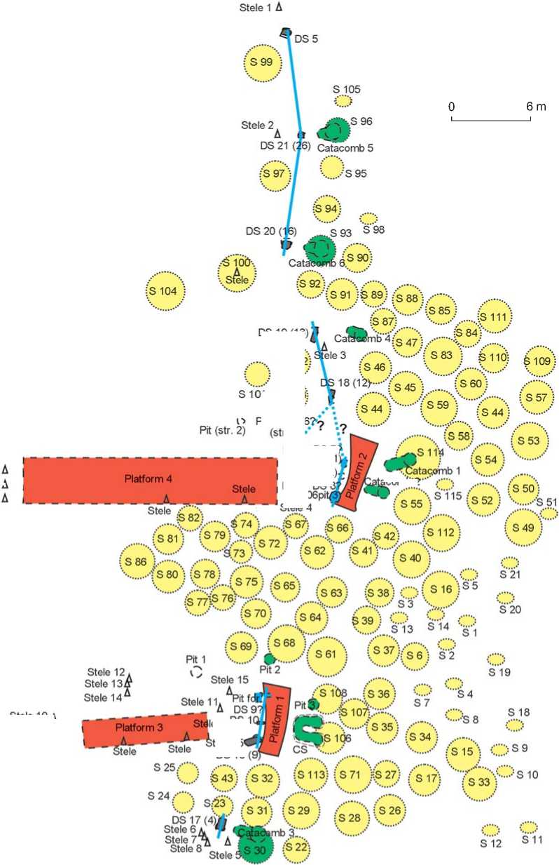
Fig. 3. Plan of the complex area examined in 2013.
S – Sacrifice Structure; DS – Deer Stone (numeration after Volkov’s and Novgorodova’s publication; additional numbers denote newly found stones; field codes of fragments of the deer stones are given in parentheses); CS – “Central Structure”: U-shaped ritual-pit; “06pit” – pit examined in 2006. Items of the initial period (catacombs and ritual-pits) are shown in green, rows of deer stones are shown in blue, structures with buried horse-bones and calcined bone-fragments are shown in yellow.
DS 19(13)
IS 102
S 103
Ie 9ads 1
tele 15
DS16(
Ensemble 1 (Fig. 4, 5). Curved Platform 1 (Fig. 5, 6) is approximately 5.2 m long; its maximum width is about 2.1 m. Its long axis, supposed to align with the chord of the eastern arc, deflects from the meridian by approximately 11° in the northeastern direction. The end sides of the platform are virtually parallel; the southern side is shorter than the northern one. Both longitudinal sides are curved. The eastern side represents part of a circle, while the
Fig. 4. Ensemble 1. View from southeast.
curvature of the western side increases southward. This elaborate shape was doubtless intentional, because it is the same as that of Platform 2 located to the north of it. The area of the platform is covered with a layer of small and flat fragments of granite. Similar granite slabs vertically dug into the ground to a depth of 0.10–0.15 m form the perimeter of the platform.
Approximately 4 m to the west of Platform 1, the rectangular Platform 3 begins. It is extended in the latitudinal direction, deflecting from the parallel by approximately 4° in the southwestern direction (Fig. 4, 5). Its long axis passes approximately through the middle part of Platform 1. The platform is approximately 9.5 m long and 2.1 wide. The walls of the platform are made of one or two layers of stones; two pointed steles are located on the southern side. One to three layers of small stone blocks fill the space between the walls. The western part of the platform is heavily damaged. Three steles of rough stone (No. 19– 21) were buried into the ground less than 2 m to the west
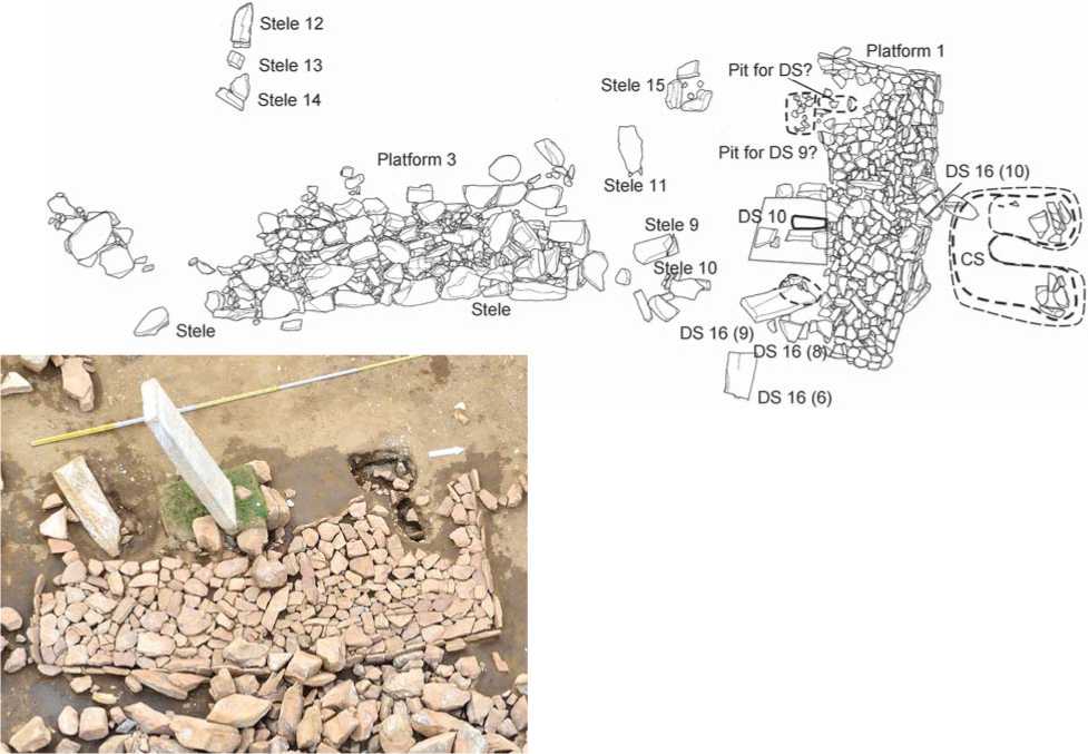
Stele 15
Platform 3
ICS
Stele
Stele
Stele 12
^ Stele 13
Stele 14
DS 16(6)
DS 16 (9) n-DS16(l
Platform 1
DS 16 (10)
Stele 11
Stele 9
Pit for DS? v
Pit for DS 9?
Fig. 6. Curved Platform 1 and Row of deer stones 1 of Ensemble 1. View from east.
3 m
Fig. 5. Plan of the central part of Ensemble 1 with the U-shaped ritual-pit (after the removal of infill).
of it, along the line parallel to the narrow side. A similar row of steles (No. 9–11) is located along the eastern side. Steles 12–15, located to the north of Platform 3, could belong to the same ensemble, although this cannot be traced on the plan.
The middle part of the western side of curved Platform 1 is covered with an infill of the pit containing Deer Stone 10, one of the few stones fully preserved in situ (Volkov, 2002: Pl. 72; 77, 1 ; Takahama Shu et al., 2006: Pl. 18, 1 ) (Fig. 5, 6). The pit was dug on the very edge of the platform. The face of the deer stone is directed strictly to the east. The excavations revealed another deer stone (Fig. 5, 6) located approximately 1.2 m to the south of deer stone 10. The pit dug for this stone passes through the western edge of Platform 1. The pit is oval, with its long axis extending along the west-to-east line. Accordingly, the narrow sides of the deer stone also have to be oriented along this line. The pit contained a fragment of the middle part of the deer stone (fragment of DS 9) installed upside down with an inclination (Fig. 5). The lower part of the stone (fragment of DS 6) rested on the ancient groundsurface, 1 m to the southwest of the pit. Two fragments of the upper part were found to the south of the pit (fragment of DS 8) and on Platform 1 (fragment of DS 10). The arrangement of fragments evidently suggests that it was the one new deer stone (named by us “Deer Stone 16”) that had been originally placed in this pit.
Two more pits, presumably intended for the deer stones (Fig. 5, 6), were found 2 m to the north of Deer
Stone 10. One of them passed through the western side of Platform 1. It was suboval, with its long axis oriented to the latitudinal direction. Probably, a “narrow” deer stone similar to Deer Stone 10 had been initially placed there. No remains of the deer stone were found in the pit. Another pit adjacent to this one on the western side is subrectangular, with its long axis oriented from north to south. Its proportions suggest that it had been fit for Deer Stone 9, which, according to Volkov’s plan, “was lying” 2 m to the north of the standing Deer Stone 10 (Volkov, 2002: Pl. 72; 76, 2 ; Takahama Shu et al., 2006: Pl. 17, 2 ). The deer stone’s upper end was broken off in ancient times. We found it among rubble located at the level of the ancient ground-surface, 3 m to the west of the pit for Deer Stone 16 (fragment of DS 7; Fig. 7). This indirectly confirms the attribution we suggested.
Thus, a row of deer stones oriented along the southsouth-west to north-north-east line was erected along the western edge of Platform 1 (Row 1).
Ensemble 2 (Fig. 8). Curved Platform 2, like Platform 1, is composed of a layer of small slabs, and bordered with similar slabs placed vertically along the perimeter. It was cleared and recorded by the Mongolian-Japanese Expedition in 2005–2006 (Takahama Shu et al., 2006: 72–73). Regrettably, the platform was heavily damaged in the course of excavations. Only separate small slabs, vertically placed along the perimeter, and a part of paved area were found in situ . Excavations conducted in 2005– 2006 had already destroyed the northwestern corner of
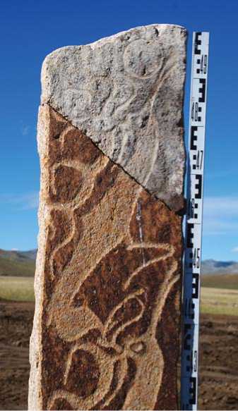
Fig. 7. Deer Stone 9.
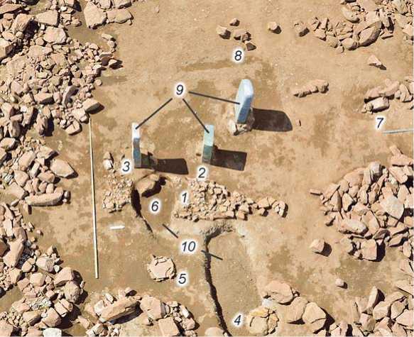
Fig. 8. Ensemble 2. Central part and surrounding items.
1 – curved Platform 2; 2 – pit for installing Deer Stone 7 (?) (pit 1); 3 – pit for installing Deer Stone 8 (?) (pit 3); 4 – Catacomb 1; 5 – Catacomb 2; 6 – Platform 2 sunk into the chamber of Catacomb 2 (destroyed); 7 – Deer Stone 18 in situ ; 8 – pit for installing Deer Stone 6 (?); 9 – displaced Deer Stone 8 and fragments of Deer Stone 7; 10 – trenches made during the 2006 expedition.
the platform; however, survived fragments of the stone perimeter allow reconstruction of the platform’s shape.
Judging by the available data, Platform 2 was similar in shape to Platform 1, though more disproportionate. It was approximately 5.4 m long; its maximum width reached 2.2 m. The narrow sides were straight and parallel to each other, the southern side being shorter than the northern one. The longitudinal eastern side was also straight, while the western side formed an arc, increasingly curved towards the south. Based on the western side, the structure was oriented 20° northeast of the meridian.
Approximately 5 m west of Platform 2, the rectangular Platform 4 begins. It is extended in the latitudinal direction. Its composition is similar to that of Platform 3. The walls are formed by large stone blocks arranged in a straight line; the inner space is filled with one or two layers of smaller blocks. The western part of the structure is heavily damaged. Three steles of rough stone (No. 16– 18) were embedded 1 m west of the platform, along the line parallel to its narrow side. One more stele (No. 4) is located between platforms 2 and 4; however, the plan offers no data as to whether it was a part of this ensemble.
In 1970, when the site was examined by Volkov and Novgorodova, at least the lower part of Deer Stone 7 was located in situ approximately at the place of Platform 2. Volkov depicted the deer stone exactly in this position (top view) on his plan and designated it as “standing” (2002: 80–81, pl. 72). Moreover, the article of 1975 (Volkov, Novgorodova, 1975: 80) reports not only the height of the aboveground part of the deer stone (1.7 m), but also its total length (3.75 m). Thus, “standing” Deer Stone 7, or its lower part, was dug out in 1970 during the survey. In the monograph, Volkov published the drawing of this deer stone with a gap in the place of the break (2002: Pl. 73, 3). So, the aboveground part of Deer Stone 7 most likely had been broken off before the work started in 1970. In 2005, Japanese researchers observed the opposite situation: the upper part of the deer stone was dug into the ground, while the lower part was located near its base. They were encircled with fragments of granite arranged in two or three rows and one layer. This circle and the lying lower part of Deer Stone 7 covered the abovementioned Platform 2. Obviously, the upper part of the deer stone was dug into the ground in this place after 1970. As far as we know, the deer stones were never placed in the center of the stone ring, implying that the ring was made in the end of the 20th century. However, there is a stronger evidence. In 2005 and 2006, the Mongolian-Japanese Expedition extracted the dug fragment of Deer Stone 7 and completely examined “pit 2”, where it was situated. Published drawings and photographs show that the pit was approximately 52 cm deep and had a diameter of 98 cm (Takahama Shu et al., 2006: Pl. 10, 11), which means that such a large deer stone could not have been installed in it. However, north of it, directly under the stone ring, another pit (“pit 1”) was found. It is 1.06 m deep and has a diameter of 0.5 m in the lower part and 1.38 m in the upper part. Its dimensions exactly match those of the lower, originally underground part of Deer Stone 7 (no drawing is provided). The pit is 1.1 m long and tapers smoothly from 0.6 m to 0.3 m toward the bottom (Ibid.: Pl. 16). This is probably the pit from which Volkov dug out the deer stone. Therefore, the stone ring above the pit must have been made after the work of the Soviet-Mongolian Expedition, and thus should not be attributed to the complex.
Pit 1, that supposedly contained Deer Stone 7, is located near the middle of the western side of Platform 2. Therefore, the position of this deer stone (which is similar to Deer Stone 10 in proportions) relative to Platform 2 is the same as that of Deer Stone 7 relative to Platform 1.
Pit 3 passes through the southwestern corner of Platform 2, as in the case of Platform 1 (Ibid.: 73, Pl. 11). This pit, examined in 2006, had a diameter of 165 cm and was 55 cm deep. It contained stones with a maximum diameter of 30 cm. These stones were probably used to fix a deer stone. For some reason, the Japanese archaeologists believed that this pit had been intended for Deer Stone 7. However, simple calculations show that the latter could not have stood upright, given that the height of its tapering underground part is only 55 cm, whereas the twice-as-wide upper part is 3.2 m. The pit most likely was made for Deer Stone 8, that was found in 1970 lying “near standing Deer Stone 7” on the southern side (Volkov, 2002: 81, pl. 72). According to the description, it was 2.3 m long, 0.4–0.5 m wide, and 0.15–0.18 m thick. Volkov’s drawing indicates that the length of its lower plain part (that was dug into the ground) was slightly less than a quarter of the total length, i.e., approximately 55 cm (Ibid: Pl. 76, 1 ). Therefore, it is probable that pit 3 passing through the edge of Platform 2 initially contained Deer Stone 8.
Thus, we can suggest that a row of deer stones (Row 2) oriented along the south-south-west to northnorth-east line was erected near the western edge of Platform 2, as in the case of Platform 1.
North of ensembles 1 and 2, two (?) more rows of structures were found. They included the deer stones, stone rings with horse-remains covered by stone heaps, and stone rings with calcined bones.
Row 3. Three meters northwest of the northwestern corner of Platform 2, we discovered in situ the lower part (fragment of DS 12) of a deer stone, subquadrangular in cross-section (named by us “Deer Stone 18”) (Fig. 3, 8). We found also new Deer Stone 19 that was initially erected north-north-east of it. Its unearthed lower part (fragment of DS 13) is located near a pit, while fragments of the middle part rested on the modern ground-surface. Apparently, this arc included another deer stone, probably formerly known as Deer Stone 6. As mentioned in the 1975 article, it had completed the “row” of the deer stones (No. 6–8, 11, 13, and 15) on the north (Volkov, Novgorodova, 1975: 80). On the plan, it is shown “lying” close to Deer Stone 7 (Volkov, 2002: Pl. 72). Volkov’s drawing (Ibid.: Pl. 75, 1) shows only the aboveground part of this deer stone, though starting from the 1975 article, its total length is described as being 3.4 m. This seems doubtful, since the length of the recorded painted part reaches only 1.9 m. However, there remains the possibility that the position recorded by the Mongolian-Japanese Expedition (Takahama Shu et al., 2006: Pl. 2) is original. Then, it was located in a row between deer stones 18 and 19 and slightly shifted to the east. At present, however, this deer stone is 8 m away from the tentative position of Deer Stone 7, which differs from the plan of 1970. It is possible that the Deer Stone 6 was initially erected farther to the south, 4 m west of the northwestern corner of Platform 2, where we cleared a pit with a diameter of approximately 0.4 m and approximately 0.8 m deep (Fig. 8). Several stone fragments were deepened in the infill of the pit; others are located around at the level of the ancient ground-surface (“structure 5”; see Fig. 3). Deer Stone 6 is 0.38 m wide and 0.27 m thick (Volkov, 2002: 80), so the pit fits for it.
If Deer Stone 6 had indeed been placed in that pit, then Row 3 was separated from Row 2 (that is, passing along the western edge of Platform 2), northwest of it. If, on the other hand, the original position was preserved, then the line which included deer stones 18 and 19 continued the arc formed by the western wall of Platform 2 and, respectively, of Row 2, which included deer stones 7 and 8 (Fig. 3).
Row 4. The next row included Deer Stone 5 standing in situ as well as deer stones 20 and 21, found by us. Only bottom parts of two these deer stones were preserved in situ dug in the ground (fragments DS 16 and DS 26, respectively) (Fig. 3, 9). No broken-off fragments of Deer Stone 21 were found, while the fragments of Deer Stone 20 (at least five) were discovered scattered over a large area of the northern part of the excavation. Row 4 has the shape of a slightly curved arc. We observed similar arrangement of the deer stones at another (10 km to the west) ritual complex with eight deer stones at Surtiin Denzh (Kovalev, Erdenebaatar, 2010: Fig. 4, 5).
South of Platform 1, we discovered isolated Deer Stone 17: its bottom part (fragment of DS 4) was found in situ, and three fragments rested on the ancient groundsurface. The pit for this deer stone was shifted to the west from the axis of Row 1 belonging to Ensemble 1. A row of three steles (steles 6–8) was located southwest of this deer stone.
East, south, and north of the abovementioned ensembles, over a hundred sacrifice structures based on shallow pits with buried parts of horse-skeletons were
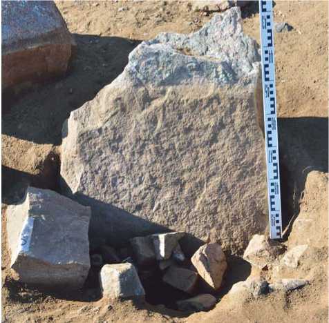
Fig. 9. Deer Stone 20 in situ . View from north.
discovered . Usually, though not in all sacrifice burial (some lack certain elements), four hooves and an upper rib were found in the bottom of the pit, whereas cranial bones and cervical vertebrae were positioned above. The hooves and crania were oriented to the east. This type of burial, frequently recorded during excavations of the structures adjoining the deer stones and khereksurs , apparently testifies to the rite that has survived in Central Eurasia. Precisely this set of skeletal elements remains after the skins, exposed for ritual purposes, decompose (see, e.g., (Potanin, 1883: 78–79)). The upper rib in the burial is supposed to symbolize the horse entrails. Small pits with horse-bones were filled with earth and, as the stratigraphic observations suggest, surrounded by rings made of one to three layers of stones, on which stone debris was heaped. The further from the center of the ensemble, the worse the quality of those structures. In certain cases, the ring is barely marked by certain rocks. On the eastern fringe of the complex, these sacrifice burials without any stone marks were located.
Our thorough examination has revealed no sacrifice structures overlapping one another. Those people who constructed them evidently avoided destroying earlier ones. The sacrifice structures do not overlap or disturb the platforms and rows of deer stones 1–4 either, suggesting that the structure had been designed as a whole . At the same time, we discovered a fragment of Deer Stone 20 in the infill of Sacrifice Structure 52 (Fig. 10). This fact suggests the long-term functioning of the complex. Drawing the lines between sacrifice structures belonging to Ensembles 1 and 2 or between the adjacent rows of Deer Stones 3 and 4 is impossible, although certain borders can be traced.
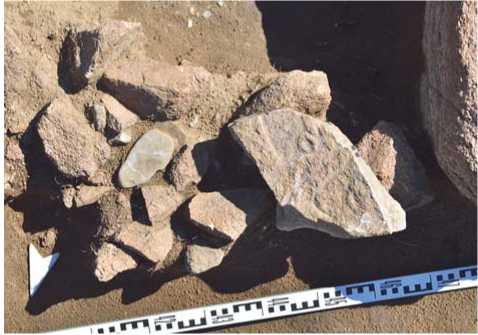
Fig. 10. A fragment of Deer Stone 20 in the infill of Sacrifice Structure 52.
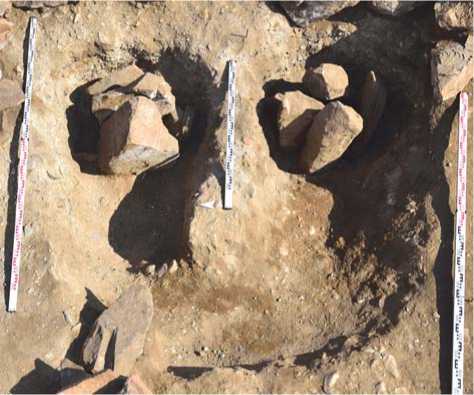
Fig. 11. U-shaped ritual-pit (view from west after the removal of the infill; the edge of Platform 1 is in the foreground).
We also discovered and examined the structures attributable either to the earliest stage of the complex’s existence, or to initial stages of forming some of its components: six catacombs filled with stones and a ritual U-shaped pit with steles dug in its bottom. Judging by stratigraphy, this pit designated in field-records as a “Central Structure” (CS) had been dug out and filled with stones before Platform 1 was constructed (Fig. 3–5). Slabs bordering the platform on the eastern side overlapped the stone infill of the ritual-pit. Moreover, the stones from the pit are located at its edge approximately 10 cm lower than the level of Platform 1. Sacrifice Structures with horsebones 106 and 108 were made above the stone infill of the ritual-pit. However, Deer Stone 10 is dug into the ground on the opposite side of Platform 1 directly along the symmetry axis of the ritual-pit; whereas the platform itself was constructed virtually on the edge of the latter, and the chord of its concave eastern side is nearly perpendicular to this line (the deviation is 3°). So the ritual-pit and the structures of Ensemble 1 were perceived as a whole.
The U-shaped pit (Fig. 11) measured 2 × 2 m in plan; its northern and southern parts were connected by a 40–50 cm bridge oriented along an east-to-west axis, deviating from it at 7° southeast. The bottom of the pit declined toward the east (from the level of approximately 0.3 m from the ancient ground-surface to the level of approximately 0.7 m). Fragments of horse-pelvis and mandible were found located in the bottom in the northern part of the pit. The pit widened toward the ends of the “branches”. Steles of raw granite were dug into the bottom of the pit: three flat steles with their wide sides oriented approximately along the west-to-east line in the northern part, and four steles oriented approximately to cardinal points in the southern part. At the western edge of the northern “branch”, a granite fragment was positioned with a depression in the upper part, possibly a sacrifice structure, oriented exactly along the east-to-west axis.
The pit was filled with stone debris. A stone block measuring 0.7 × 0.6 × 0.5 m was positioned above. The upper facet of the block has a hole with a diameter of approximately 0.1 m (Fig. 12). The surface of the hole is covered with an organic substance (a sample was taken for chemical and genetic analyses). Numerous radial cracks run from the hole. They might have resulted from the freezing of the liquid with which the hole had been filled. No doubt the rock had initially served as a ritual item, but it apparently had been reused as the depression was slanted.
Each catacomb is a vertical shaft, with a diameter of up to 1 m and up to 1.6 m deep. An undercuts 0.8–1.5 m long (Fig. 13, 14) were made at the western walls of pits.
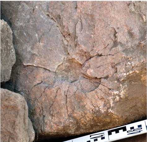
Fig. 12. Stone with a hole in the infill of the U-shaped ritual-pit.
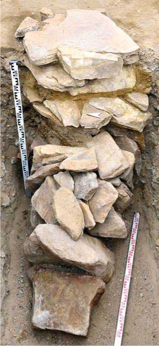
Fig. 13. Catacomb 2. View from west.
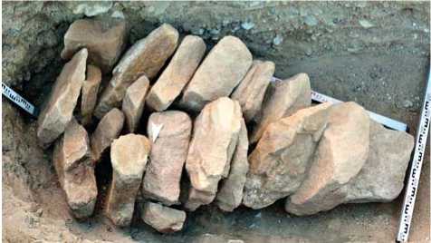
Fig. 14. Catacomb 2. Infill of the chamber. View from north.
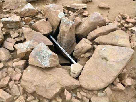
Fig. 15. Catacomb 6. View of the entrance shaft from southeast.
The entrance to the chamber was closed with a stone slab. There were several slabs in Catacombs 1 and 2. The shaft was tightly stuffed with stones. Stone rings accompanied Catacombs 3, 5, and 6 (Fig. 15). These rings (“Sacrifice Structures” 30, 93, and 96) represented shape of the same structures but without horse burials. The shaft of Catacomb 1 was overlapped by sacrifice structure with horse burial 114 (“stone heap 1” according to numbering system of 2006) (Takahama Shu et al., 2006: 71, Pl. 10); same Sacrifice Structure 31 covered Catacomb 3. Part of Platform 2 had sunk into Catacomb 2; in 2006, it was mistaken for “pit 4” (Ibid.: 73–74, Pl. 11, 5 ).
The arrangement of catacombs suggests that they were included in some composition unity with Ensemble 2 (Catacombs 1 and 2), with rows of deer stones 3 and 4 (Catacombs 4–6) and with Deer Stone 17 (Catacomb 3). Because certain shafts were overlapped by sacrifice structures, the people who had arranged the sanctuary either did not know where the entrances to the catacombs were, or ignored them. Therefore, it is not clear if these structures belonged to any ensemble.
The tentative results of excavations at Uushigiin Uvur demonstrate that the structures accompanying deer stones compose exactly the same architectural ensembles as structures around khereksurs of Central Mongolia, as we had already demonstrated at Surtiin Denzh (Kovalev, Erdenebaatar, 2007, 2010). We observe the same composition of stone rings with buried horse-bones and rectangular stone platforms with steles at the khereksurs of Uushigiin uvur, Zhargalantyn am, Urt bulagyn, Tsatsyn ereg B09 and В10, and others (Takahama Shu et al., 2006: Pl. 2; Tөrbat et al., 2011: Vol. 53–54; Allard, Erdenebaatar, 2005: 547–551; Erdenebaatar, 2007; Magail, 2007: 115–116). This confirms the idea that the real mounds with graves were replaced by the deer stones (Kovalev, Erdenebaatar, 2007: 104). Thus, all deer stones in Central Mongolia were used as cenotaphs substituting actual persons who had died but were not buried in the khereksurs for some reason (see (Tishkin, Grushin, 1997) for the notion of cenotaph). Now, we have obtained new evidence of that the Eurasian deer stones were meant as a ritual “substitution” for a dead person. Actually, in certain cases, the deer stones had been intentionally buried in the mounds of the Early Scythian period in Tuva (Kovalev, Rukavishnikova, Erdenebaatar, 2014).
