Albazin, a Russian town on the Amur: population size in the late 1600s

Author: Nesterov S.P.
Journal: Archaeology, Ethnology & Anthropology of Eurasia @journal-aeae-en
Section: The metal ages and medieval period
Article in issue: 2 т.45, 2017.
Free access
Short address: https://sciup.org/145145302
IDR: 145145302 | DOI: 10.17746/1563-0110.2017.45.2.113-122
Text of the review article Albazin, a Russian town on the Amur: population size in the late 1600s
Fort Albazin was built in 1665 by the Cossack ataman N.R. Chernigovsky, at the site of fortified winter quarters destroyed in 1651 (by a detachment commanded by E.P. Khabarov) that, in turn, were erected on the territory of Yaksa town, in the lands of Daurian Prince Albazy (Novikov-Daursky, 1961: 16). In the 1680s, Fort Albazin became the largest settlement in Eastern Russia, and was turned by the Russians into an outpost for development of the Amur River basin (Fig. 1, 2). It is considered the first capital of the Russian Amur region (Cherkasov et al., 2012: 28).
Information on Fort Albazin can be obtained from written sources that describe various episodes of the fortress’s history (Artemiev, 1999: 102), as well as from the abundant archaeological materials discovered during excavations. Finds collected by the Amur Museum expedition “near the base of the western rampart currently being destroyed by flood water” were mentioned by S.G. Novikov-Daursky (1961: 17). Archaeological excavations at the Fort Albazin site were carried in 1974–1976 and 1979–1980 by the Amur party (headed by S.V. Glinsky) of the North Asian Joint Expedition of the Institute of History, Philology and Philosophy of the SB USSR Academy of Sciences, over
*Supported by the Russian Science Foundation (Project No. 14-50-00036).
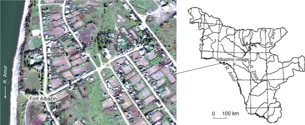
Fig. 1 . Location of Fort Albazin in the territory of Albazino village, the Amur Region.
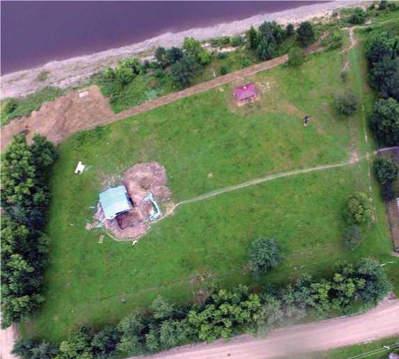
Fig. 2 . View of Fort Albazin from the eastern side (Albazinskiy ostrog…, (s.a.)).
an area of about 400 m2*. From 1989 to the beginning of the 2000s, excavations at Fort Albazin were conducted by the Amur Archaeological Expedition (headed by A.R. Artemiev) of the Institute of History, Archaeology and Ethnography of the Peoples of the Far East FEB RAS. During these years, a fortarea of 819 m2 has been studied (Artemiev, 2007: 131). In 2007 and 2013, a party of the Center for the Preservation of Historical and Cultural Heritage of the Amur Region (headed by D.P. Volkov) carried out salvage operations in an area of 143 m2on the western side of Fort Albazin. In 2011–2016, this site was an object of multidisciplinary studies conducted by the Albazin Archaeological Expedition (headed by A.N. Cherkasov), created by the Petropavlovsk foundation with support from the Center for the Preservation of Historical and Cultural Heritage of the Amur Region. Within a period of six years, the expedition has excavated a fort territory of 236 m2, and discovered numerous artifacts and anthropological remains.
Thus, about 1670 m2 of the Fort Albazin area have been studied by excavations up to now, which totals about 15 % of the 1686 fortress’s territory within its outer boundaries (including towers, ramparts and the moat). Comprehensive studies have yielded a lot of new information about Fort Albazin; however, there are still many issues in its history to be solved.
Dynamics of Fort Albazin’s size
The first issue involves inconsistencies between the data on Fort Albazin’s size and the levels of its destruction in various periods of its existence, which are available in the scientific literature.
The first Russian Fort Albazin had a size of 13 × × 18 sazhens*, or 28 × 39 m (Kradin, 1992: 74), which totals 1092 m2. It was provided with palisade fencing, two towers on the Amur-facing side, and one tower on the field-facing side. In 1677, a moat 2 sazh. (4.32 m) wide was dug out, and a fence in the form of six rows of sharpened pillars, arranged in star-shapes, was erected around the fort. According to a written report by Albazin’s estate-manager A. Voeikov: as early as 1681, as a result of rebuilding, the fort whose sides totaled 165.5 sazh. (357.5 m) in length had two gate-towers and three cornertowers. The voivode ’s yard was located in the northwestern corner. A palisade accommodating 53 dwelling houses was located near the fort (Glinsky, Sukhikh, 1992: 20). In view of the threat of Manchu attacks, new walls and towers had been erected by the summer of 1693 in order to strengthen the defensive capability (Artemiev, 1999: 107). A description of Fort Albazin, signed by voivode A.L. Tolbuzin, who took over the command of the fortification from estate manager M. Voloshnikov in 1684, is preserved in the archive of the Russian Academy of Sciences. This document indicates the lengths of the fort’s sides: the northern side 85 m, the southern side 83 m, the western side 97 m, and the eastern side 92 m (Ibid.: 110).
According to data from the topographic survey conducted by S.V. Glinsky and V.V. Sukhikh in 1974, the fortress, in plan view, had the form of a parallelogram, wherein the northeastern corner was 105º, and the southeastern corner was 85º. The length of the northern side (partially destroyed by caving of its bank) was 70 m, the eastern side reached 90 m, and the southern side (also destroyed by the Amur River) was more than 56 m. The eastern and northern walls were straight, while the southern wall, which followed the shape of the terrace’s edge, curved outwards (Fig. 3) (Glinsky, Sukhikh, 1992: 17–18). According to the archival information and to the present-day archaeological, topographical, and geophysical data on the size and configuration of the walls, the fort had an irregular quadrangular shape (not in the form of parallelogram); in 1684, the area of its interior space was about 7630 m2; and the perimeter was 357 m, which is in agreement with the fortress’s perimeter in 1681. Excavations of portions of wall, carried out by A.R. Artemiev, have revealed the presence around the fort of wooden palisade fencing made of vertical logs (1999: 279–281, fig. 61–63); possibly, voivode Tolbuzin meant the size along the palisade fencing when indicating the length of the fort’s sides.
It is believed that the fort, newly built in 1685–1686, had a length of walls on the inner side similar to that of the fortress burned out in June 1685, after the first Manchu siege: it was erected in the same place. Meanwhile, the earthen base of the ramparts (which was 8.64 m wide and
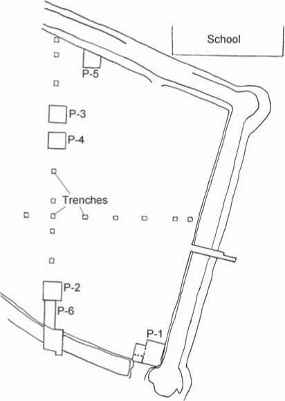
Fig. 3 . Layout of Fort Albazin drawn up by S.V. Glinsky and V.V. Sukhikh in 1974 (Sukhikh, 1979: 169, pl. 1).
3.69 m high) of the new fortification presumably started from the palisade fencing burned out in 1685. This is evidenced by data from the geophysical survey conducted in 2011: the length of the interior portion of the eastern rampart reached 92 m (Cherkasov et al., 2011: 62).
Taking into account that the modern area of the interior space totals 6333 m2—rather than the 4000 m2 according to Cherkasov (2014: 674), and rather than the 7630 m2 according to the data of the 17th century (Artemiev indicates an area of 8000 m2 (Fig. 4) (1999: 109))—the following conclusion can be reached: over a period of 333 years, the fort had lost 17 % of its area, where 15 % (according to Artemiev, who proceeded from the layout drawn by R.K. Maak (1825–1886), an explorer and researcher of Siberia and the Far East) had been lost within 140 years after its destruction (Ibid.: 115); exactly in this period, the 8.64 m wide western rampart, facing the Amur, was totally lost (Fig. 5).
Number of defenders of Fort Albazin in 1686
The second issue involves identification of the number of people who were in the fortress in the first days of battle, and during the siege of 1686; and of the reasons for the great casualties among the defenders, since the available data vary.
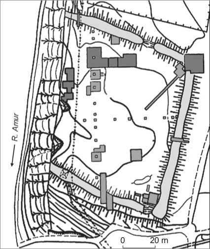
Fig. 4 . Layout of Fort Albazin drawn up by A.P. Artemiev (1999: 276, fig. 58).
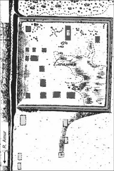
Fig. 5 . Layout of Fort Albazin drawn up by R.K. Maak in 1855 (Artemiev, 1999: 273, fig. 55).
1984: 43), who probably lived in the 53 houses of the palisade rather than in the fortress: i.e. about 550– 640 people in total. As early as the summer of 1684, according to Manchu intelligence data, the size of Albazin population reached approximately 900 people, including 400 people who came from Nerchinsk (Melikhov, 1974: 157). In 1685, during the first siege, 450 persons took refuge in the fortress. Having regard to the fact that the initial area of the fortified settlement was about 7630 m2, there were ca 17 m2 for each of 450 Albazin inhabitants. Their accommodation would have required approximately 50–56 dwellings.
In 1686, the number of defenders became even greater: on July 26 (the beginning of the battle), the Albazin population numbered 826 servicemen, hunters, fishermen, and ploughmen (Bagrin, 2013: 104). In this case, there would be ca 9 m2 for each Albazin inhabitant (whether that be a man, a woman, or a child). To accommodate everybody, at least 100 dwellings would have been required, or at least 50 “earthen houses”, considering that some men kept rotational guard-duty in the first days. In 1686, Fort Albazin did not have so many living quarters, specialized premises (gunpowder magazine, grenade warehouse, church) or auxiliary rooms*.
The layout of Fort Albazin drawn up by Maak in 1855 shows depressions that correspond to 13–14 buildings (Fig. 5) (Artemiev, 1999: 273). The dugout excavated by Artemiev had a size of 6.0 × 3.5 m, i.e. 21 m2, where an area of 2.25 m2 was occupied by an oven. Such dwellings could have accommodated no more than 10–12 persons. “Earthen houses” excavated by Glinsky and Sukhikh were smaller: No. 1 was 3.4 × 2.0 m (6.8 m2), No. 2 was 3.2 × 3.0 m (9.6 m2). According to Sukhikh, each of them could have accommodated 2–5 persons (1978: 143). The conclusion about the small number of log houses follows from the report submitted to voivode I. Vlasov by Cossacks I. Buzunov, V. Baksheev and Y. Martynov, who in November 1686 managed to get out of the besieged fort and leave for Nerchinsk. They particularly noted the lack of firewood: there were not many log structures that could have been dismantled to make it; in addition, the amount of water was insufficient: as was proposed by Sukhikh, during the cold season, it was gone from the fortress’s water-well, while the route to the Amur River was cut off by the besiegers. The excavations of the well revealed that a wooden ladder was lowered down therein, so that accumulating water could have been scooped out by a bailer (also found at the bottom of the well) (Sukhikh, 1979: 85).
In 1682, the population of the town of Albazin, as Manchu called the fort (Melikhov, 1974: 173), consisted of 222 Cossacks of the fortress’s garrison and, according to various estimates, 330–420 peasants (Aleksandrov,
A drawing of the Albazin siege from the Chinese atlas Map Aihun, Luosha, Taiwan, Nei Menggu tu of 1697 shows ca 65 wooden houses, including two adjoining large tent-roofed structures (Fig. 6) (Aihun…, (s.a.)). According to Artemiev, the author, who was probably a witness to the events, presented in the same image the sieges of the fortress conducted both in 1685 and in 1686–1687. Near the northwestern edge of the fortress, he showed a chapel “in log obstacles” burned out in 1685 (Artemiev, 1999: 112–113). The large number of buildings depicted is inconsistent with the data on the scarcity of log houses given in the report of the Cossacks who left the fort in November 1686.
A drawing made by Dutch explorer Nicolaes Witsen (1641–1717) depicts Albazin during the second siege (Fig. 7). Only eight buildings, including three armament depots, are shown in its territory.
Thus, the available stock of housing in the fortress was extremely limited. Obviously, the number of those who took refuge in the fort (450 persons) in 1685 was beyond this limit; the main garrison could have totaled ca 220 persons, as in 1682. The besieged fortress, insufficiently provided with water and firewood, just could not have accommodated 826 persons.
The numbers involved in the Russian losses are startling: as early as December 6, 1686, five months after the beginning of battle and siege, only 150 defenders remained in the fortress, i.e. the decline in population amounted to 676 persons. In May 1687, six months later, there were only 66 persons there, including teenagers. Presuming that 450 persons (in 1685) and 826 persons
(in 1686) stayed in the fortress simultaneously, we can make an assumption about the reasons so many were killed, or otherwise deceased. One is severe overcrowding, which resulted in numerous victims when cannonballs and bullets hit targets inside the fortress. For example, more than 100 persons were killed during just one day of the siege in 1685 (Aleksandrov, 1984: 142). Among other factors were starvation due to insufficient food, shortage of water and firewood, and “siege” illnesses (in October 1686, epidemics burst out even among the Manchus who were besieging the fortress) (Melikhov, 1974: 179). However, according to Manchu intelligence data, Albazin possessed stocks of bread for two years, (Ibid.: 174), and these could barely have become exhausted to the point that people began starving to death massively. It is known that in spring 1687 the fortress defenders handed over a large loaf of bread to the Manchus, who were already seriously starving, as a symbolic “treat” (Artemiev, 1999: 108). People who sheltered themselves in Albazin were probably suffering badly from scurvy. This illness usually starts within 1–3 months in the full absence of vitamin C, and within 4–6 months in the case of insufficiency. V.A. Aleksandrov reported more than 500 people who died of scurvy (1984: 150). The losses among Albazin’s inhabitants over the period till December 1686 and till May 1687 amounted to 82 % and 56 %, respectively. Obviously, they were considerable during the second stage as well, though smaller by a third compared to the beginning of the siege.
The combat activity of the Manchus decreased with the onset of cold weather. In addition, on November 13, 1686, a letter from the Moscow government with a
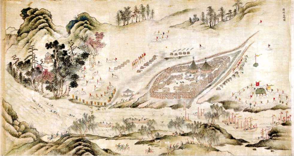
Fig. 6 . Drawing of Fort Albazin siege from the atlas Map Aihun, Luosha, Taiwan, Nei Menggu tu (Aihun…, (s.a.)).
request to abandon the siege of Albazin, signed as early as December 10, 1685, was delivered to the Kangxi Emperor (Chinese ‘Xuanye’). Obviously, the siege that took place in summer 1685 was meant. Kangxi, in light of the political and military situation at hand in 1686, ordered his troops to draw off from the Russian fortress; to move away to the Manchu ships (near the mouth of the Uldugichi River, about 3.0–3.5 km upstream the Amur River from the fortress); not to prevent the Russians from leaving the town and returning; and to permit no arbitrary actions towards them. However, it was only on May 13, 1687 that the Manchus fell back, by a distance of 10 km; while the actual raising of the siege occurred no earlier than August 19, 1687 (Melikhov, 1974: 180–181).
Thus, the heavy mortality among the fortress’s defenders after November 1686 was a result of poor nutrition and illnesses, rather than military activities. Paradoxically, a wrong idea of the size of the town of Albazin can be considered one of the reasons for great losses during the first months of defense.
Boundaries of the town of Albazin
The third issue may be defined as follows: are we correct in restricting the territory of the town of Albazin to the fortress’s limits alone?
Fort Albazin’s remains are situated on the salient promontory of a high terrace. Southward, perpendicular to the Amur River and an abrupt riverside, there is a steep slope with the southern rampart of the fort raised thereon, to which a floodplain terrace adjoins. To the east of the fortress, the terrace’s surface lowers smoothly towards the scour of a dried brook (Glinsky, Sukhikh, 1992: 17).
In 1686, the Manchu troops, having failed to seize the fortress at one go, besieged it and dug moats on three sides, behind which they constructed a wooden fence and chevaux-de-frise, and also built embankments for cannon. Security posts were located everywhere. On the other bank of the river, on an island west of the fort, a Manchu detachment was quartered. Two moats and three ramparts arranged archwise near the fortress, and at a certain distance from it, are clearly seen in the drawing by N. Witsen (Fig. 7). Artemiev discovered three rows of ramparts 800 m east of Fort Albazin. Two of these are preserved in a section 100 m long; the third (outer) rampart has been traced in a section 300 m long. The present-day width of ramparts is 6 m, their height is 1 m, and the moats have a depth of up to 50 cm. One rampart northeast of the fortress runs 300 m from it. In the opinion of Artemiev, the ramparts formed part of the Manchu fortifications. At the same time, the embankment for cannon that was erected by the Manchus on the northern side of the fortified settlement (known as “Batareyka” among the local population) was located as close as 150 m from the fortress (Artemiev, 1999: 115); apparently, the builders took into account the range of artillery-fire in the 17th century.
The impracticality of the double cordon of fortifications created by the Manchus is evident. The fact that the near fortifications were erected for siege and defense is evidenced by the Kangxi’s order that mentioned digging the moats (Melikhov, 1974: 177). Consequently, the Russians were engaged in frequent combat operations. According to the available data, the Albazin’s defenders destroyed the embankments for Manchu cannon south of the fortress, prevented the fortress from being set on fire, etc. None of the written sources contains any information about the construction or the purpose of the three-rampart defense system 800 m from the fort. It is unlikely that the Manchus had cannon capable of bombarding the fortress from such a large distance. There are data only
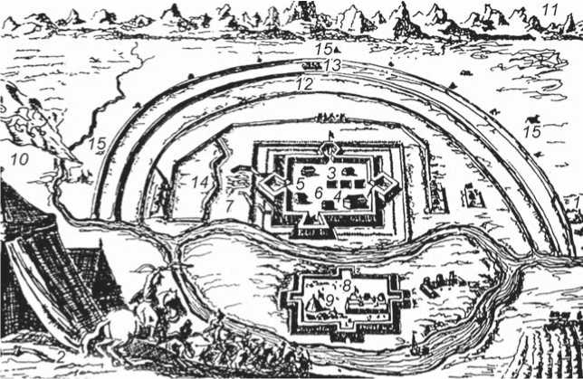
Fig. 7 . Representation of the siege of Albazin fortress in 1686 provided in a book by Nicolaes Witsen (Artemiev, 1999: 275, fig. 57).
1 , 2 – dugouts of the Manchu command; 3 – dugouts; 4 – armory; 5 – grenade magazine;
6 – gunpowder magazine; 7 – firewood for burning the fortress; 8 – Manchu fortifications opposite Albazin; 9 – Manchu general’s tent; 10 – Belaya mountain; 11 – Kamennye mountains; 12 – moat; 13 – trench-lines;
14 – close positions of Manchu; 15 – Manchu camp.
about construction of trenches, a rampart, and four small platforms for cannonry 150–200 sazh. (320–430 m) from the fortress walls (Aleksandrov, 1984: 149).
It is possible that this complex fortification, consisting of three parallel ramparts and moats adjacent to the fort, was erected neither by Russians nor by Manchus (although it might have been used by them). The caption to the drawing by Witsen mentions the “moat excavated by reinforcements of the Manchu cavalry” under No. 12, and “Manchu trench lines (sconces)” under No. 13 (Fig. 7) (Ibid.: 153). This fortification system could have been created by representatives of the Mohe Troitsky group in the Early Middle Ages. It was exactly the Mohe people of the Western Amur region who gradually colonized the territory in the upper reaches of the Amur River and in the Southeastern Trans-Baikal region: their fortified settlements enclosed by a system of ramparts and moats are known near the Shilka River (Alkin, 2012). Promontory Mohe settlements are found in the territory of Far East and Manchuria (Istoriya Amurskoi oblasti…, 2008: 140–142; Dyakova, 2009: 190–196). The results of excavations in the Uldugichi River mouth reveal the presence of Mohe in the area of Albazino (Valchak, Cherkasov, 2014). Possibly, the remains of the triple rampart near the Albazino village are a part of the structure that enclosed the Albazin cape.
The fortified settlements, referred to as Daur in the archaeological literature, were erected following the same principles (in the form of several parallel ramparts and moats). They are attributed to the Vladimirovskoye culture of the Late Middle Ages, whose ethnic representatives were the Mongolian-speaking Daurs (Bolotin, 1995). The Albazin’s ramparts apparently belonged to the Daurs: the town of Prince Albazy, who could have created a defense system enclosing the Albazin cape to ensure additional fortification, was situated exactly in this area. It may well be that the aboriginals of the 17th century used the earlier fortifications of the cape and kept them in working order. The town of Albazy could have included the territory enclosed by three ramparts, and the citadel that was occupied and then burnt out by people of Khabarov in 1650. It is not improbable that in 1680s these ramparts and moats were clearly visible along their entire length, which is why they are present in the drawing made by Witsen.
In preparation for seizure of the fortress, Manchu intelligence established in 1683 that “an additional wooden palisade [my italics – S.N. ] was constructed around the town of Albazin, inside which palisade the above mentioned 53 dwelling houses were located. The peasants from the neighboring lands were resettled to the town. An observation point, from which five people watched over the area in rotation day and night, was established on the top of a nearby mountain” (Melikhov, 1974: 157). In 1684, double wooden walls, with the space between them covered with soil, were erected around Albazin.
According to Chinese intelligence data, the manpower in the Russian forces reached a thousand people (Ibid.: 165). Thus, accommodation for a thousand people (apart from peasants, hunters, etc.) in the fortress with an area about 7.6 thousand m2 was barely probable. Obviously, this number included inhabitants of the territory enclosed by the three ramparts strengthened by the wooden palisade. It is not quite clear where the double wooden walls covered up with soil were constructed, since during the first siege in 1685, Manchu cannonballs penetrated the fortress’s walls. What had happened to the town’s inhabitants, totaling more than a half of the population, if only 450 persons took refuge in the fortress? Probably, a part of the population spread out in the neighboring forests, while another part was killed. After defeat in the first siege, Tolbuzin led 636 Albazin survivors, including 324 men and 312 women and children, to Nerchinsk in the Trans-Baikal region (Aleksandrov, 1984: 143), although only about 350 persons left the besieged town.
Approximate calculations of the size of Albazin’s population in 1683–1686 and the fort’s area during these years allow a conclusion to be drawn that the fortress was only the citadel (stronghold) of the town, whose boundaries were limited by an additionally fortified line of defense composed of three ramparts and two moats. The traces of the trading-quarter in the form of six dwellings south of the fort, marked by Maak in his layout (see Fig. 5), can be considered an indirect proof of this.
The data provided by those who examined the Albazin fortress’s remains in the 19th century differ considerably in details. Thus, N.Y. Bichurin described the fortress as a “quadrangle of up to 60 Russian sazhens (about 128 m) across, which can be noticed even now by an earth threesided rampart surrounded by a moat, with three exits from the fortress. A steep bank slopes down towards the riverside, and no rampart can be seen there” (cited after (Ibid.: 146)). Notably, N.N. Muravyov-Amursky (the Governor-General of Eastern Siberia in 1847–1861) identified the fortress of Albazin as a citadel, which presumes the presence of one more fortification around it. This fortification around a considerable area is also mentioned by ethnographer S.V. Maksimov (1831–1901), who visited Albazino in the early 1860s. He wrote: “…the fortress’s area is so large that a modern Cossack village of 40 households was located inside an earth rampart four sazhens at the base and three sazhens in height; seemingly, remains of a water-well were near the bank, and those of a bricked gunpowder magazine were found upon a mountain” (cited after (Ibid.)). It is unlikely that 40 households could have been accommodated in the territory of Fort Albazin, the more so since the church built in 1858 would have occupied a considerable space therein. There is no mountain within the fortress either (see Fig. 2). The nearest prominence is situated ca 300 m east of the fortress. According to data from military engineer D.I. Romanov, published in 1857, Fort Albazin “had the form of a quadrangle or a square” with a side of 40 sazh. (about 85 m), one of which ran along the crest of a bank cliff (Ibid.).
If the town of Albazin included more than the fort, the reason that the Manchus were unable to seize a rather well-fortified citadel-fortress surrounded by a wide and deep moat comes to be understood. The excavations have demonstrated that the moat’s width on the eastern side exceeded 7 m (the moat was not explored thoroughly, since it went beneath a street of Albazino village), its depth was 2.8 m, the bottom’s width 2.2 m, and the angle of inclination of its sides reached 35º. Besides, there was ground ca 1 m wide between the moat and rampart of the fort (Glinsky, Sukhikh, 1992: 23).
Initially, the main battles would have been conducted beyond the fort’s walls, on the outer defense line composed of triple ramparts with a wooden palisade. This may be evidenced by a report by the Cossacks who arrived to help the Albazin defenders, but were unable to force their way to them. The Cossacks noted that “the combat order was maintained in Albazin, and no particular damage was visible, though the enemy’s cannonry threw continuous fire into the walls and towers of the fortress from three sides” (Aleksandrov, 1984: 149). There might not have been serious damage, because the cannonballs’ flight was impeded by a three-rampart enclosure located at a substantial distance from the fort. Manchu Qing historical records as of September 10, 1686 stated: “…our troops besieged the town of Albazin. The Russians found themselves in a difficult situation” (Melikhov, 1974: 176). But it was not until October, after three months of battle, when the ranks of the defenders thinned, that this line was seized by the Manchus; the remaining Albazin inhabitants (Cossack warriors, women, and children) took refuge in the fortress. Possibly, this event is related to the October orders issued by Kangxi, which mentioned a defense-siege system composed of earthen walls, moats, wooden fence, and chevaux-de-frise created by the Manchus in the immediate vicinity of three sides of the fortress. The Kangxi Emperor noted in his order to the Military Governor of Heilongjiang: “Cold weather is gradually coming, the rivers will freeze soon. Obviously, after return to Albazin [my italics – S.N. ], the Russians will be waiting for reinforcements to arrive; they hope that our troops will move away as soon as the river freezes over” (Ibid.: 177). By the “return of the Russians to Albazin”, Kangxi, most likely meant their leaving the trading-quarter for the fort, to find protection within its walls.
On the basis of the proposed definition of the Albazin town’s boundaries, we can assume that the main military and civil losses were incurred by the defenders beyond the walls of the fortress. And it was there that they should have been buried.
Four mass-casualty burials of people in dugouts (halfdugouts), and separate scattered burials in coffins have been excavated in the territory of Fort Albazin. The first “common grave” was discovered by Glinsky and Sukhikh in 1980. There is no exact information about the number of people buried in dugout No. 3. Study of field-drawings allows the presumption that about 80 people, including children, were buried there. Three mass-casualty burials of the fortress’s defenders from 1686–1687 were found by the expeditions headed by Artemiev and Cherkasov. The remains of 57 people were discovered in a dugout 6.0 × 3.5 m in size, excavated by Artemiev; and only one skeleton was found in a coffin. Among the buried, there were 10 women and a few children (Artemiev, 1999: 113). A mass-casualty burial in a dugout 2.8 × 3.8 m in size (an area of 10.6 m2), found in 2014, contained the remains of 64 people, including 13 children and adolescents. The only persons buried in coffins were: a 4–5-year-old child and a 14–15-year-old adolescent in one coffin, and an adolescent 14–15 years old in another (Sorokin, (s.a.)). One more common grave was found at the end of the 2015 field season. According to Cherkasov, this was a dugout, “where people, who died or were killed during the siege, were nearly stacked up” (Kozyrin, 2015). Anthropological studies have established that it contained the remains of not less than 40 persons (Sezon raskopok…, (s.a.)). Thus, the excavations have determined that about 241 persons were buried in four dugouts (or “in winter huts above the ground”, as the Cossack chief, lieutenant A.I. Beyton, reported to the Nerchinsk voivode (Artemiev, 1999: 108)). Two separate burials were discovered in 1975 near the base of the southern rampart. The skeletons were laid side by side; one of them was between planks, and another one in a coffin. Hearth-masonry was placed at the head of the latter. According to stratigraphic observations, the burials were performed in the period of the fort’s destruction in 1689 (Sukhikh, 1979: 43–44). Cherkasov relates 19 individual coffin-burials discovered in 2015 to the period of fort defense in 1686, when the defenders still were able to observe the burial rite (Kozyrin, 2015). It is logical to assume that the leader of the defense, Tolbuzin, who, obviously, was killed in the western tower during shelling of the fortress from the Amur River side, was honorably buried within the fortress; his death happened on the ninth day of Manchu attacks (Aleksandrov, 1984: 149). Possibly these burials in coffins were performed after capitulation of the Russians in 1685, when more than 100 people perished, or in the period after the siege was raised in 1687–1689. Cherkasov reasons that up to 1 thousand people could have been buried within the limits of Fort Albazin (2014: 674).
When circumstances had forced the town’s defenders to shelter within the fortress’s walls, there was obviously no possibility of burying the deceased outside of the fort. And even after Kangxi issued the directive of December 10,
1686 that prohibited preventing the Russians from leaving the fortress (Melikhov, 1974: 179–180), the latter were already unable to perform proper funeral ceremonies. Furthermore, the local priest died, and Beyton made a decision to put bodies in the “earthen houses”, since there was no possibility of reading a funeral service for the deceased. The main reason for using dugouts was the mass mortality of the fortress defenders from illnesses, and lack of people to perform individual burials (for example, in December 1686, only 45 out of 150 people were able to draw their duties).
Conclusions
Study of changes in Fort Albazin in the second half of the 17th century has made it possible to establish the approximate size of its inner area in 1686, when it was besieged by Manchu troops; and after the Treaty of Nerchinsk (1689) was signed between Russia and China, when it was
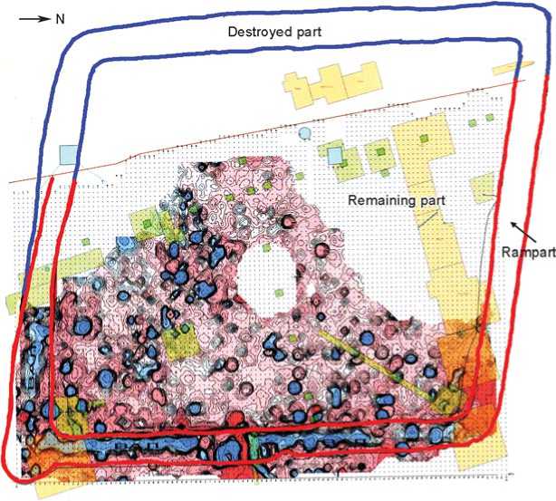
Fig. 8 . Reconstruction of Fort Albazin’s boundaries in 1686, made on the basis of the 2011 geophysical layout.
abandoned and destroyed by Cossacks (Stepanov, 2011: 58). The fortress, 7.6 thousand m2 in area with one waterwell and small number of dwelling houses, could easily have accommodated about 220 members of the military garrison; but it was insufficient to house more than 820 people in a state of siege.
Analysis of Russian losses during the defense of Albazin has demonstrated that by October 1686, as a result of two Manchu assaults (in July and September) and during outfalls, 66 persons were killed, including voivode A.L. Tolbuzin. 50 persons died of scurvy. By this time, according to the report submitted by Beyton, “about eight hundred officers and other ranks remained” in Albazin [my italics – S.N.] (Bagrin, 2013: 104) out of 826 people, according to his own data. That is, the voivode did not possess precise information on the number of people in the fortress, though about 130 persons had already been killed or died by that time. In November-December 1686, another 100 persons were killed during outfalls and shelling, more than 500 persons died of scurvy, and 3 men left the fort to deliver a report. Taking into account 66 people who survived until May 1687, the initial total number of the besieged should have been 866 rather than 826 people. It appears that 800 people died or were killed. Possibly, a considerable part of the more than 500 people who died of scurvy fell on the period before November 1686. At this time, the epidemic might already have been rife in the fortress. Then the figure of 500 people would reflect total losses caused by the illnesses throughout the siege, among which 50 persons died as early as September. So far, the discrepancies in these written sources concerning the number of people who were killed, died of illnesses, or survived do not allow an exact determination of the number of defenders who were found in the fort by November 1686.
Taking into account 241 persons buried in four dugouts, 66 survivors*, and 3 Cossacks who managed to leave the fort to report on the siege as early as November 1686, we may refer to 310 persons who sheltered in the fortress, but not to 826 (or 866) persons. Apart from Cossacks, they included women and children of various ages. It is not improbable that the latter had taken refuge in the fortress since the beginning of the battle, while the Cossacks conducted warfare in the territory of the town enclosed by three ramparts. And only after great losses had been incurred under the onslaught of superior enemy forces, did they retreat to the citadel (Fig. 8), not stopping combat operations even then. The Manchus never succeeded in seizing the last stronghold of the town of Albazin, and passed over to the defensive themselves.
