Ancient irrigated soils of the Bozok archaeological district, Northern Kazakhstan (11th to 12th centuries)
")
Author: Gavrilov D.A., Khabdulina M.K.
Journal: Archaeology, Ethnology & Anthropology of Eurasia @journal-aeae-en
Section: The metal ages and medieval period
Article in issue: 4 т.46, 2018.
Free access
Short address: https://sciup.org/145145403
IDR: 145145403 | DOI: 10.17746/1563-0110.2018.46.4.083-093
Text of the review article Ancient irrigated soils of the Bozok archaeological district, Northern Kazakhstan (11th to 12th centuries)
Irrigation of soils in arid conditions is one of the most ancient and widespread methods for increasing the fertility of agricultural lands (Andrianov, 2016; Groshev, 1996). Irrigation is an indicator of a society’s level of development, and of its adaptation to restricted natural resources (low-productivity soils) when provision of agricultural farming products is necessary. Therefore, ancient irrigation systems are a traditional object of study in archaeology (Gulyamov, 1957; Andrianov, 2016; Sunchugashev, 1990; Groshev, 1996).
When an irrigation system is constructed and operated, the landscape undergoes considerable transformation. Digging of canals, creation of water storage basins, irrigation erosion, compaction of surface soil layer, formation colmatage, landslides, and suffosion result in changes of relief. Traces of irrigation and accompanying natural phenomena under arid climatic conditions persist over a span of many thousands of years, which
allows these to be used as the most reliable evidence of developed agriculture in ancient societies. They are generally studied by conventional archaeological methods (topographic survey, photofixation, and search of similar objects in adjacent territories and in other chronological periods). However, studying evidence of irrigation that appeared during the functioning of an irrigation system in soil as a backbone element of the irrigation system is beyond the compass of archaeology; therefore, the help of science-based methods (pedology, phytolithology, botany, etc.) is invaluable here.
During archaeological works in the Bozok archaeological district, the remains of an ancient irrigation system were discovered, adjacent to the ruins of the Bozok medieval settlement (Fig. 1) (Gavrilov, 2008: 372). In order to reveal traces of irrigation, an archaeological and pedological survey was conducted, and surface and buried soils of structural parts of the irrigation system were studied at various elements of the catena.
Materials and methods
The Bozok archaeological district is situated in the Nura-Ishim interfluve, on the eastern coast of Lake Buzykty, on the residual outcrop of an elevated beach ridge, within the city of Astana (Fig. 1). The area of the Bozok ancient settlement is more than 30 ha. Using archaeological and radiocarbon methods, the site has been dated to the 8th to 14th (15th) centuries (Khabdulina, 2011: 284–290). The functioning of the irrigation system pertains to the 11th to 12th centuries (Gavrilov, 2008). Archaeological and topographic study has demonstrated that the Bozok irrigation system is an architecturally complex aboveground structure (Khabdulina, Gavrilov, 2007).
When creating the irrigation system, the builders took into account special features of the relief that determined the direction and speed of the water flow, and the delimitation of the system into areas with predetermined soil moistening properties. The locations of irrigated soil pits were tied to the functional parts of the irrigation system, located at various parts of the catena, such as El-, Trans-1, and Trans-2 positions.
Ancient irrigated soils are represented by two groups of soils: 1) buried Antroposol (Loamic, Calcaric, Salic, Aric, Irragric) and 2) surface Abruptic Salic Gypsic Chromic Solonetz (Clayic, Cutanic, Hypernatric) of the soil of ramparts, garden beds, principal canals, and diversion canals (aryks) (IUSS Working Group WRB, 2014). Protocalcic Chernozem (Loamic) buried under the rampart of the 7th–8th century settlement was selected as background for analysis (Gavrilov, Dergacheva, Khabdulina, 2011: 8). The general physical and chemical properties of the soils were studied by standard methods accepted in pedology (Khimicheskiy analiz…, 1998).
Ancient irrigated soils have been successfully diagnosed in various arid regions of the world using microbiomorphic analysis (Rosen, Weiner, 1994; Madella et al., 2009; Trombold, Israde-Alcantara, 2005; Grana, Cohen, Maidana, 2014; Jenkins et al., 2016), which is based on studying mineral (phytoliths, sponges, diatom algae) and organic (spores, pollen grains, fungal threads, detriti, etc.) biomorphs. Each of the microbiomorph species reflects the environmental conditions of its formation (Golyeva, 1997, 2001, 2008), and also has a great stability in time.
The materials were interpreted in compliance with the methodological developments proposed by A.A. Golyeva (2001, 2008). This researcher has distinguished the microbiomorph type as a special soil profile type, which is formed throughout the entire life of the soil, and records changes of environment, pedogenic factors, or human-induced impact in its qualitative and quantitative characteristics. As pedogenic conditions and phytocenosis characteristics change, one microbiomorph profile is gradually replaced by another; however, the general stratigraphic regularity of recording these phenomena remains in the microbiomorph’s profile characteristics: lower samples are more ancient than those located closer to the daylight surface level. The depthwise distribution of biomorphs is also a diagnostic feature of a normal pedogenesis model or profile disturbance as a result of erosion losses, material washovers, or agroturbation (Golyeva, 2001; Svirida, Golyeva, 2016).
The most informative part of the microbiomorph profile is the phytolith profile’s composition, which consists of universal (adiagnostic) forms of Dycotyledoneae phytoliths, ecological groups of phytolith complexes belonging to various phytocenoses (taiga, meadow, steppe, dry-steppe), and phytoliths belonging to certain families ( Cyperaceae sp., Pinaceae sp.) or plant species (“signal forms” (after (Golyeva, 2001)), for example, Phragmites spp.
To reveal statistically significant evidence of the soil’s excessive moistening as a result of irrigation on the basis of data on microbiomorph profiles of background and ancient irrigated soils, the following multidimensional statistical methods were used: principal component analysis (PCA), discriminant method, and correlation method. A group of these methods allows the graphical representation of the arrangement of study objects in a multidimensional space according to their discriminating features, and also the revelation of the statistical significance of differences among the study objects and relations among the features and discriminated groups (populations).
Statistical treatment was carried out by means of the Past 2.0 program (Hammer et al., 2001).
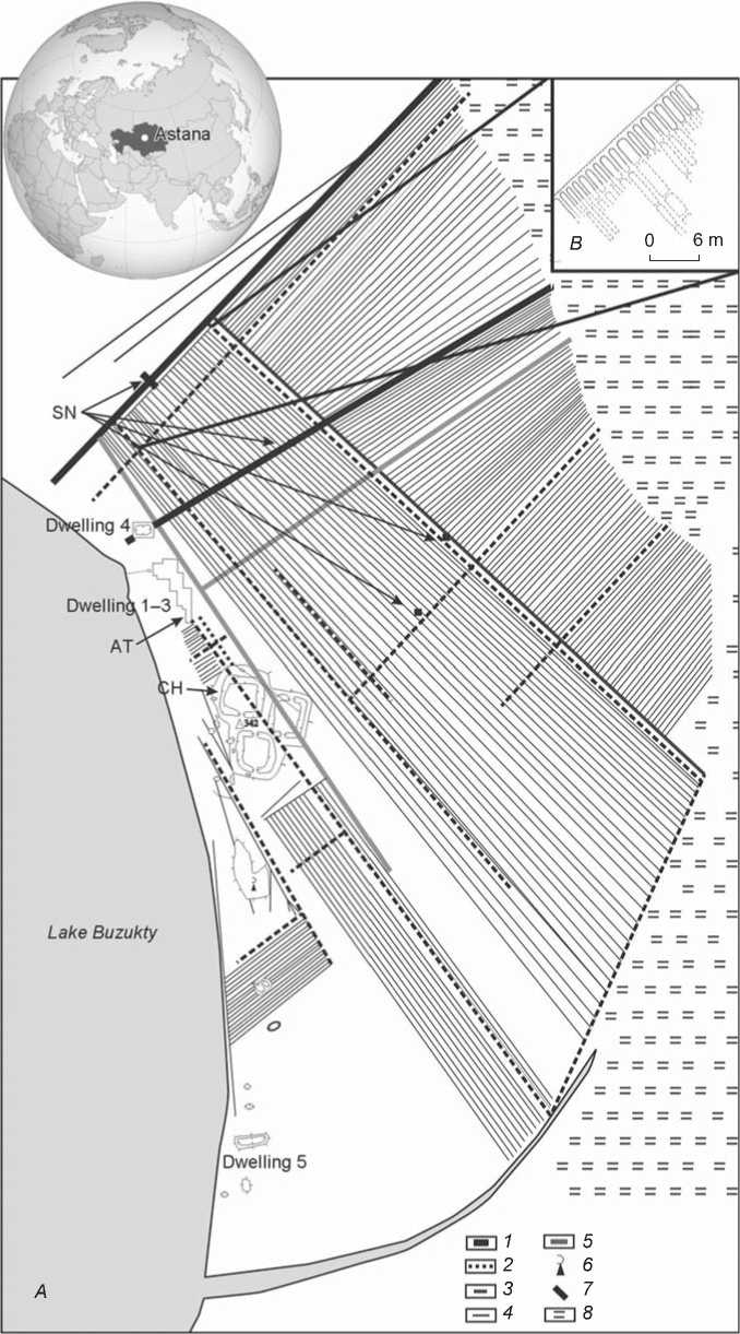
Fig. 1. Layout of the irrigation system of the Bozok site. Scale 1 : 5000.
A – arrangement of study object: 1 – principal canal, 2 – ridging, 3 – distributor, 4 – diversion canal, 5 – drainage canal, 6 – Muslim cemetery, 7 – location of pit, 8 – grass bog; B – layout of garden beds.
CH – buried Protocalcic Chernozem (Loamic) ; AT – buried Antroposol (Loamic, Calcaric, Salic, Aric, Irragric) (11th–12th centuries); SN – Abruptic Salic, Gypsic, Chromic Aric Solonetz (Clayic, Cutanic, Hypernatric) .
Results and discussion
Morphology of soil profiles. To reveal the irrigation traces in the structure and properties of soils, the buried soil under the settlement rampart ( Protocalcic Chernozem (Loamic) [A] (0–10(20))–[A/B] pc (20–40)–[B] pc (40– 90)) was selected as background (Gavrilov, Dergacheva, Khabdulina, 2011: 8–9).
The buried soil under the wall remains of dwelling 3 (790 ± 35 BP (SOAN-7328), the date was established with animal bones) was determined by us as Antroposol (Loamic, Calcaric, Salic, Aric, Irragric) ( ancient irrigated ) ([A] ai, ac, sz ] (0–10)–[AB/ B] pc, sz (10–30)– [B]pc, sz, gy (30–90)). Unlike the background (nonirrigated) soil, it has an agroturbated humus horizon with deep humic tongues, and is salinized along the entire soil profile.
Abruptic Salic Gypsic Chromic Aric Solonetz (Clayic, Cutanic, Hypernatric) ( ancient irrigated ) (Aai(0–8(15))– E sz (8(15)–35)–B sz, pc (35–55)–BC sz, pc, gy (55–90)) prevail in the soil cover of the archaeological microdistrict (Fig. 1). They differ markedly from the above soils by the presence of solonetz soil formation and traces of hydromorphism (iron oxide forms with gray single spots of ferrous iron). The morphological examination of the profiles of ancient irrigated soils has not revealed any evidence of ancient plowing (an even lower boundary of the plowing horizon or the presence of compaction in the underplow pan). Only during vertical cleaning of excavation units at the boundary of the plowing horizon did we manage to record one-way lines-traces of plow passage.
General physical and chemical properties. Buried Protocalcic Chernozem (Loamic) (background)
was formed on channel and floodplain alluvium of heterogeneous origin, which explains sandy-loam texture of humus horizon, and a heavier (loamy) texture in the lower part of the soil profile (Table 1).
The distribution of the soil organic carbon (SOC) in ancient soil is characterized by the surface-accumulative type: about 1 % in the humus horizon, and less than 0.7 % in the mineral horizons. The magnetic susceptibility (MS) runs parallel to the total carbon: it varies in the humus horizon within 0.9–1.1·10 -6 CGSE/g, gradually decreasing to a depth of 1 m, and then virtually fluctuates in a very small range. In all soil horizons, the alkaline value (pHwater 8.2–8.7) gradually increases with depth.
Formation of this soil took place at a relatively increased rate of moistening, which caused desalination of carbonates into deeper horizons; therefore, the upper part of the profile contains small amount of these, and the maximum falls at a depth of 39–67 cm. Since carbonates in the humus horizon are encountered in the form of impregnation, it is believed that the ancient soil was formed in warm and moderately humid conditions.
The soil has characteristics of humus profile typical for steppe soils, such as: a gradual decrease in humic acids (HA) with depth, an increase in fulvic acids (FA) in the same direction, “scissoring” intraprofile distribution of humus acids (Table 1), predominance of lime humates (HA fr. 2) in humic acids, uniform distribution and small share (2–5 %) of HA fr. 3 (Khabdulina, Gavrilov, Dergacheva, 2011: 444). Such a composition of humic substances points to the chernozem type of pedogenesis under warm and moderately humid conditions (Ponomareva, Plotnikova, 1980).
Table 1. Physical and chemical characteristics of buried soils
|
Horizon * |
n ** |
SOC, % |
χ·10-6 CGSE/g |
pH water |
СаСО 3 , % |
СHA : СFA * 4 |
< 0.01 % |
< 0.1 % |
|
Protocalcic Chernozem (Loamic) (background) |
||||||||
|
[A] (0–15) |
3 |
0.8 ± 0.1 *** |
0.9 ± 0.2 |
8.2 |
1.0 ± 0.56 |
1.4 ± 0.2 |
11.6 ± 3.4 |
16.3 ± 4.8 |
|
[A/B] pc (19–39) |
5 |
0.5 ± 0.1 |
1.0 ± 0.1 |
8.4 ± 0.1 |
5.3 ± 3.7 |
0.6 ± 0.2 |
14.9 ± 1.0 |
20.3 ± 1.7 |
|
[B] pc (39–90) |
6 |
0.2 ± 0.1 |
0.7 ± 0.1 |
8.6 ± 0.1 |
12.4 ± 1.6 |
0.3 ± 0.1 |
13.8 ± 2.3 |
22.8 ± 1.5 |
|
Antroposol (Loamic, Calcaric, Salic, Aric, Irragric) (ancient irrigated) |
||||||||
|
[A] ai, ac, sz (0–10) |
1 |
2.5 |
1.8 |
8.5 |
0 |
1.95 |
17.6 |
21.5 |
|
1 |
1.5 |
2.0 |
8.5 |
0 |
1.56 |
15.0 |
26.4 |
|
|
[AB/ B] pc, sz (10–30) |
1 |
0.8 |
1.5 |
8.5 |
0 |
1.99 |
15.4 |
27.0 |
|
4 |
0.7 ± 0.1 |
1.2 ± 0.1 |
8.7 ± 0.1 |
0.2 ± 0.2 |
1.2 ± 0.4 |
16.9 ± 0.8 |
28.0 ± 4.0 |
|
|
[B] pc, sz, gy (30–90) |
4 |
0.3 ± 0.1 |
0.8 |
9.0 ± 0.1 |
11.4 ± 1.7 |
0.5 |
17.6 ± 1.2 |
33.7 ± 1.5 |
*Here and elsewhere in brackets—a depth from the ancient soil surface, cm.
**Here and elsewhere—the number of samples taken from different depths in the same horizon.
***Data on physical and chemical properties presented as a mean value ± standard deviation, if n ≥ 2.
*4СHA– humic acid carbon, СFA– fulvic acid carbon.
In the buried Antroposol (Loamic, Calcaric, Salic, Aric, Irragric) , distribution of the total carbon along the profile is also characterized by the surface-accumulative type, from 2.5 % in the [A]ai, ac, sz horizon to 0.2 % in the [B]pc horizon (Table 1). However, the content of SOC in the humus horizon is 2.5 times higher than that in the background soil. This fact should be explained by additional enrichment of the upper part of the humus horizon in lacustrine sapropel, which could have got here with irrigation water; this is consistent with the results of microbiomorphic analysis.
MS has increased values in the [A]ai, ac, sz and [AB/ B]pc, sz horizons, where it reaches 1.2–2.0·10 -6 CGSE/g, being about 0.8·10 -6 CGSE/g in [B]pc, sz, gy. The lower part of horizon [B]pc, sz, gy in this soil, as well as in other soils of the Bozok settlement, has corresponding close values (0.7–0.9·10 -6 CGSE/g). Samples from the humus horizon generate inversion in the MS value: the underlying sample demonstrates an increased MS with respect to the overlying one (Table 1).
Studying the humus’s composition has demonstrated that the humus-accumulative stratum shows the humate type of humus (CHA : CFA= 1.6–2.0), which changes to the fulvate-humate type and then to the fulvate one (Table 1). The most mobile fulvic acids are accumulated in the lower part of the profile and reach 12–13 % of the total carbon there (Khabdulina, Gavrilov, Dergacheva, 2011: 445). Profile “scissoring” distribution of the main humus components, as well as the absolute values of the ratio between the humic acid carbon and the fulvic acid carbon, is typical of steppe soils (Ponomareva, Plotnikova, 1980). Untypical distribution of the indices of ratio between the groups of humic acids (CHA : CFA) and MS has been revealed along the humus profile in the humus horizon, which confirms the proposal about disturbance of natural structure of the humus horizon as a result of agrogenic turbation (plowing).
The reaction of the soil medium is characterized as strongly alkaline (pHwater 8.5–9.1). The maximum of CaCO3 falls at a depth of 30–70 cm from the ancient soil surface, the upper 20 cm part of which is leached to remove carbonates.
The soil profile is salinized. The quality of salinity is sulfate-chloride. The distribution of dissolved solids along the profile shows two peaks confined to the upper boundary of the buried surface of the humus horizon and to the transition zone between the humus and textured-carbonate horizons (Table 2). This feature is clearly associated with the stages of intraprofile accumulation of salts during the periods of soil exposure and its burying (diagenesis). Most probably, the soil was leached to remove salts up to the upper boundary of the textured-carbonate horizon during irrigation works, while the degree of salinization was considerably lower than the modern level.
Analysis of the physical and chemical properties of Abruptic Salic Gypsic Chromic Aric Solonetz (Clayic, Cutanic, Hypernatric) shows clear differentiation of the profile. The distribution of SOC along the profile is regressively accumulative (Table 3). The second maximum in the SOC content is confined to the lower boundary of the [AB/ B] horizon, which is explicable as the result of plowing, where the accumulative-humic part of the profile was displaced to a depth of nearly 30 cm.
The reaction of the soil solution medium in the Aai horizon is slightly acidic or neutral, and changes abruptly to the alkaline one in the solonetzic horizon. The Solonetz profile is differentiated by the silt fraction. Its washing-out from the eluvial horizon and accumulation in the solonetzic one is observed. This horizon is also distinguished by a change in the soil absorption complex: its increase, an abrupt reduction in the share of Ca +2 , and increase in Na + are observed.
The microdistrict area is poorly drained, owing to the support of ground waters by the surrounding water bodies (the Ishim River, Lake Buzykty, and Lake Taldykol), which causes the soil salinization process under conditions of arid climate. Analysis of aqueous extract has demonstrated that the upper boundary of the salt deposit falls on the eluvial horizon, and dissolved solids amount to 0.7 % here. The maximum of salts is confined to the solonetzic stratum here and covers the upper part of the BCA horizon. Here, the content of salts reaches 1.9–2.2 % in total. The quality of salinity across the entire profile is chloride-sulfate, with the presence of gypsum (Table 3).
The results of morphogenetic analysis and study of the physical and chemical properties of the soils show typical differences between the buried and surface agrogenically transformed soils, which is related to the change in
Table 2. Analysis of aqueous extract of Antroposol (Loamic, Calcaric, Salic, Aric, Irragric)
|
Horizon |
n |
Dissolved solids, % |
HCO 3 – |
Cl– |
SO 4 – |
Ca2+ |
Mg2+ |
Na++ K+ |
Сl–: SO 4 – |
|
[A] ac, sz (0–7) |
2 |
2.1 ± 0.1 |
0.6 |
4.0 ± 0.1 |
23.8 ± 0.9 |
10.4 ± 0.8 |
7.2 ± 0.6 |
10.7 ± 0.6 |
0.1 |
|
[AB/ B] pc, sz (7–28) |
3 |
1.6 ± 0.2 |
0.6 |
4.9 ± 0.4 |
16.7 ± 2.9 |
5.0 ± 1.9 |
6.7 ± 0.8 |
10.5 ± 0.6 |
0.2 |
|
1 |
2.2 |
0.6 |
6.6 |
22.9 |
8.2 |
9.1 |
12.7 |
0.2 |
|
|
[B] pc, sz, gy (28–70) |
4 |
1.5 ± 0.4 |
0.5 |
6.4 ± 0.8 |
15.1 ± 4.0 |
6.8 ± 2.3 |
5.1 ± 1.3 |
10.0 ± 1.3 |
0.3 |
Table 3. Physical and chemical properties of Abruptic Salic Gypsic Chromic Solonetz (Clayic, Cutanic, Hypernatric) (ancient irrigated, principal canal)
Microbiomorph study. The microbiomorph composition of soil humus and subhumus horizons was studied with special attention given to the evidence of watering (diatom algae, sponge spicules, reed phytoliths) and plowing (regressive distribution of microbiomorphs) (Table 4).
The microbiomorph complex of the background Protocalcic Chernozem (Loamic) of the 7th–8th centuries was analyzed using samples from the humus horizon (sq. 22/H and 25/O). In the surface sample (0–1 cm), the microbiomorph fraction shows a medium content of amorphous organics and a low content of detritus and pollen grains. Phytoliths are numerous, sponge spicules are few. Below, at a depth of 4–5 cm, the concentration of biomorphs increases. Phytoliths of steppe grain varieties occupy a considerable proportion of the phytolith spectrum. Sponge spicules are single. In the lower part of the humus horizon (9–10 cm), the content of biomorphs is drastically reduced. The phytolith spectrum reflects the formation of steppe phytocenosis.
Thus, a relatively moderate content of phytoliths in the upper sample and the presence of pollen grains therein, as well as a higher content of amorphous organics, suggest strong degradation of steppe phytocenosis at the time of the soil’s burying. Degradation of the vegetation cover could have been a result of using this area for cattle-grazing. A small thickness of humus horizon (15 cm) as compared to that of zonal soils confirms the severe erodibility of the soil. No evidence of plowing or additional excessive soil moistening is revealed.
Strong enrichment of the microbiomorph fraction is observed in a surface sample (0–1 cm) of buried Antroposol (Loamic, Calcaric, Salic, Aric, Irragric) . Many intact sponge spicules and several specimens of diatom algae have been discovered. Phytoliths of steppe grain varieties and reed phytoliths are represented in the phytolith spectrum. A small proportion of them is charred.
At a depth of 4–5 cm, the characteristics of the microbiomorph fraction are similar to those of the previous sample. At the same time, it is distinguished by a greater enrichment in diatom algae and microcoals. The content of phytoliths in the microbiomorph fraction is somewhat lower than in the previous sample. A single cuticle of, presumably, millet ( Panicum sp.) was discovered (Houyuan Lu et al., 2009).
Table 4. Distribution of siliceous microbiomorphs, diagnostic types and groups of phytoliths, pcs / %
|
о CL |
со |
"Г |
S1 го е о О' £ го о в" го н о ф О и S 7 |
СМ tiro |
О 3 |
О 3 |
О 3 |
О 3 |
О ■Ь см tiro |
о 3 |
О 3 |
О 3 |
е о го о UJ ^ со со tiro d o' в, о" .о го V) 6 О' го о о го о о е Ч |
о о |
О О |
О О |
ГО 1 о" е 3 О o' I у ф е 5 о V) о ■с О о го $ о го V) о 1 -Q |
С О го о CL ш го с го о го .о. о о: |
л см |
л |
О О |
О О |
О О |
ГО 5 см го с го о |
о см |
О 3 |
О 3 |
О 3 |
О 3 |
О 3 |
|
1^ |
со |
О 3 |
о 3 |
о 3 |
о 3 |
о 3 |
о 3 |
о 3 |
д |
д |
о о |
о о |
О о |
д |
о о |
о о |
со |
д 3 |
о 3 |
CD 3 |
о 3 |
д 3 |
||||||||
|
со |
СМ |
о 3 |
о 3 |
о 3 |
о 3 |
о 3 |
о 3 |
о 3 |
д |
о о |
д |
д |
у о |
д |
о о |
о о |
д см |
д 3 |
3 |
О Д1 |
д |
о 3 |
||||||||
|
ю |
о 3 |
со |
о 3 |
о 3 |
со со ю |
со 3 |
о 3 |
со ю |
СО см см см |
у |
со со ю |
со (М о |
о о |
о о |
со Д1 3 3 |
3 3 со со |
3 3 |
Ю |
о 3 |
о 3 |
||||||||||
|
"Г |
о |
со ю СМ |
о со со |
о Д см |
о 3 |
3 со см |
см со со |
о 3 |
о со о> со |
со |
3 3 |
о (М о со |
о (М о |
о о |
о о |
ю Д1 3 со см |
ю Д1 3 со |
Д1 |
Ю |
о 3 |
о 3 |
|||||||||
|
со |
со |
О 3 |
со со СМ |
о 3 |
о 3 |
ю |
о 3 |
о 3 |
ю |
д |
S |
3 |
со о со |
ю со |
о о |
о о |
см |
3 |
3 со |
О 3 |
о 3 |
о 3 |
||||||||
|
СМ |
со |
о 3 |
о 3 |
о 3 |
о 3 |
о 3 |
3 |
о 3 |
у со |
о о |
о о |
со см |
о о |
о о |
л |
3 |
3 |
Ю |
о 3 |
о 3 |
||||||||||
|
1^ |
о 3 |
о 3 |
о 3 |
о 3 |
о 3 |
о 3 |
о 3 |
д |
о о |
о о |
д см |
^ |
о о |
о о |
о о |
о о |
о 3 |
^ |
О 3 |
о 3 |
о 3 |
|||||||||
|
ГО ё |
со |
о о ю |
о о 3 |
о о со |
о CD 3 |
о CD со |
о CD ю |
о CD 3 |
о CD ю со |
о CD СО СО со |
о CD |
о CD со |
о CD О О |
о CD СО 3 |
о CD |
о CD |
о CD о со со |
о CD 3 со со |
о CD 3 СО |
О CD 3 СМ |
о |
о 3 |
||||||||
|
0) ГО го £ о .ГО 5 |
LO |
о 3 |
о 3 |
о 3 |
о 3 |
со со см |
ю |
о 3 |
со |
у |
со 3 |
Ю СМ см |
СО о |
о о |
о о |
со Д1 3 со см |
ю 3 см |
со |
О 3 |
о 3 |
о 3 |
|||||||||
|
го го СП о 8" |
^ь |
д 3 |
д |
со 3 |
о 3 |
со |
см |
о 3 |
со |
ю |
о см |
о |
со |
о |
о о |
о о |
Д1 3 см |
^ 3 |
3 |
о 3 |
о 3 |
|||||||||
|
Jz о Е о о о |
ГО о |
со |
о о со ю |
о о ю со |
о о ю |
о CD о |
о CD 3 о |
о CD 3 ио |
о CD 3 |
о CD со со |
о CD О СМ |
о CD о> CD ю |
о CD о> CD со |
о CD Ю см |
о CD о> ю со |
о CD |
о CD |
о CD 3 со см |
о CD ю |
о CD Ф |
о CD Si |
о CD |
о CD 3 |
|||||||
|
Е о го Q |
СМ |
о со со СМ |
ю со со |
о т со со |
ю т |
со 1 CD со |
со ю со |
о т со со |
о со 1 со см |
Ю СО СО |
о т со со |
ю |
CD 7 СО |
ю |
о см 1 со |
ю см см |
ю |
CD 7 СО |
ю |
о СМ 1 со |
ю см см |
о со 1 О> см |
||||||||
|
го о о го —1 |
3 со N1 СП |
со со со N1 |
см со со N1 СП |
со со N1 СП |
см со N1 СП |
3 N1 СП |
о со N1 СП |
ю со N1 |
3 N1 QQ |
со со N1 |
со со N1 |
СО N1 |
со со N1 |
ю со N1 |
со N1 |
ю со N1 |
СО LO СО N1 |
ю ю со N1 |
ю со N1 |
со ю со N1 |
см ю со N1 □0 |
|||||||||
Table 4 (end)
|
"Г |
о о |
О о |
о о |
о о |
о о |
Л |
ю |
о о |
|||
|
со |
О о |
о о |
о о |
о о |
о о |
о о |
о о |
о см |
о о |
||
|
CM |
д со |
со |
о о |
со |
см |
со |
о см |
о о |
|||
|
^ |
co co LO co |
СМ СО О см |
ю со со оч |
о о |
со to |
о 04 со |
о 04 СМ Ю |
^ to |
о о |
||
|
О |
co 8 CM |
о 04 О LO |
оч о |
о о |
со to |
5 со со |
3 СО см |
5 LO |
о о |
||
|
co |
co CM CO |
о> 8 |
со LO |
о о |
см со со |
со о со |
LO со CM |
о о |
|||
|
co |
см to s M' 6 05 05 о c о to g Q |
О О |
л СМ |
о о |
ю |
см to си ■6 CQ |
со |
со со |
у со |
LO |
о о |
|
1^ |
co |
Д СМ |
со |
о о |
о о |
см |
д |
^ |
о о |
||
|
co |
о о со LO о |
О О |
о о |
о о о см |
о о см см |
о о см со со |
о о О) 04 ю |
о о co ю |
о о со |
||
|
LO |
co LO co |
СО |
со о |
о о |
см со со |
о |
04 |
о о |
|||
|
'Ф |
04 CM |
О |
со |
о о |
со 5) |
со со |
co |
о о |
|||
|
co |
О о см CM |
О О О О со |
о о о о со |
о о о см |
о о 05 со |
о о о со |
о о о со ю |
о о 3 |
о о со |
||
|
CM |
LO |
о |
о см |
ю см |
ю |
о |
ю |
о см 1 |
ю 04 |
||
|
3 |
со |
см |
3 |
со |
04 |
||||||
|
co co co |
со со со |
со со со |
ю со со |
со со со |
(О со |
со со со |
ю со со |
8 со |
|||
|
№ |
№ |
№ |
№ |
№ |
№ |
№ |
№ |
№ |
|||


The microbiomorph fraction composition in the sample (9–10 cm) from the underlying layer is close to the samples from the upper layers. However, the content of phytoliths, sponge spicules, and diatom algae is higher therein.
Thus, this soil profile was exposed to additional moistening by waters from a shallow water-body, which is evidenced by diatom algae, sponge spicules, and reed phytoliths. In addition, the regressive distribution of phytoliths along the profile suggests additional tillage operations during agricultural works (Svirida, Golyeva, 2016).
The microbiomorph composition of the Abruptic Salic Gypsic Chromic Solonetz (Clayic, Cutanic, Hypernatric) (the principal canal) sample at a depth of 4–5 cm is strongly enriched in the microbiomorph fraction with reference to the buried ancient irrigated soil (Table 4). There are a lot of fragments of sponge spicules and intact diatom algae. The phytolith spectrum is dominated by phytoliths of steppe grain varieties. In addition, a relatively large number of phytoliths of reed and weeds have been revealed. Amorphous organics and detritus are many. Cuticles of plant tissue are single.
At depths of 9–10 and 14–15 cm, samples are also strongly enriched in the microbiomorph fraction. There are a lot of fragments of sponge spicules and intact diatom algae. The phytolith spectra are identical to the spectrum of the overlying sample, and contain the phytolith complex of steppe phytocenosis and reed phytoliths.
In the transition position of the catena, Solonetz of the distributing canal, diversion canal, and ridging were studied. A large concentration of microbiomorphs with reference to the soils of ridging and soils located upward along the catena is noted in the surface samples (4–5 cm) of canals. The sample is strongly enriched in the microbiomorph fraction. Many sponge spicules and diatom algae have been discovered, with intact specimens prevailing among the latter. The phytolith spectrum is dominated by phytoliths of steppe grain varieties; a relatively large number of phytoliths of reed and weeds have been discovered. Amorphous organics and detritus are many. Cuticles of plant tissue are single.
The number of microbiomorphs downward of the profile, at a depth of 9–10 cm, is greater than in the sample from the overlying layer. The sample contains many microbiomorphs, including sponge spicules, diatom algae, and phytoliths; the phytolith complex of steppe phytocenosis and reed phytoliths. Cuticles of plant tissue are single.
The lower part of the humus-eluvial horizon also demonstrates an increase in the concentration of phytoliths, sponge spicules, and diatom algae, which decreases abruptly at a depth of 19–20 cm.
With a general resemblance of samples from the ridging in the composition and profile distribution of microbiomorphs, the microbiomorph fraction concentration therein is 4 times lower than in samples from the canals and irrigated field. This is due to the fact that the ridgings were not flooded with water that carried over fine particles and microbiomorphs downward the catena.
Thus, the studied samples contain a rather great number of microbiomorphs, among which diagnostic elements are present, such as diatom algae, sponge spicules, and reed phytoliths. Also, in the studied ancient irrigated soils, a small amount of amorphous organics and pollen grains in the samples from the lower part of the humus and solonetzic horizons with reference to the overlying samples corresponds to the general logic of accumulative distribution of substances along the soil profile. At the same time, a great content of phytoliths and diatom algae in the underlying samples of the humus-solonetzic part of soil contradicts the logic of profile distribution of other biomorphs. This fact is explained by the permanent accumulation of phytoliths and diatom algae in this part, with periodic replowing of the profile layer, which resulted in a decrease in their concentration in the upper part of the soil and their accumulation at the bottom (Svirida, Golyeva, 2016).
During irrigation, transfer of microbiomorphs in space took place: from the soils located in upper catena positions (El-position) to the soils of canals and irrigated fields located below. In addition, during nearly a 900-year post-meliorative stage of soil functioning, new accumulation of microbiomorphs took place, which caused a relatively accumulative distribution of microbiomorphs unlike irrigated soils that were in the buried state and preserved regressive-accumulative distribution of microbiomorphs (Table 4).
Statistical treatment of the results of microbiomorph analysis. The discriminant analysis has confirmed differences in the microbiomorph complexes of soils by the presence of ancient irrigation traces according to Root 1 (Fig. 2). Background buried Chernozem soil is located in the negative half of the coordinate system, while ancient irrigated soils are in the opposite half. According to the results of correlation analysis of the microbiomorph complex composition and Root 1 with p < 0.05, a strong relationship (r = 0.7–0.99) has been revealed between the group of ancient irrigated soils and the discovered splinters of sponge spicules, intact diatom algae skeletons, and saddle-shaped and bulliform phytoliths. There is an average correlation (r = 0.5–0.69) with the splinters of diatom algae skeletons, elongate dendritic forms of phytoliths, and the total sum of phytoliths and microbiomorphs. The discovered correlations point to overmoistened conditions of soil functioning; these include skeletons of sponge spicule microorganisms, diatom microalgae, and fan-shaped phytoliths of reed ( Phragmites sp.). Dendritic phytoliths often determine a group of cultivated grain varieties, which, with a great
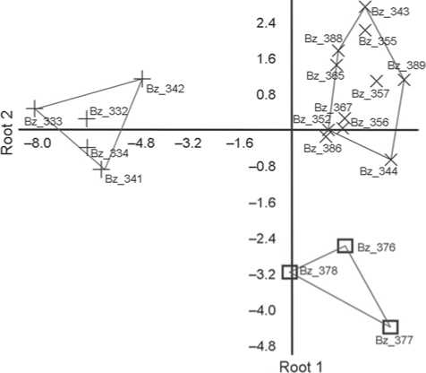
Fig. 2. Distribution graph of microbiomorph complexes of the studied samples in the space of two roots. Background: buried CH – Bz_333–Bz_342; ancient irrigated soils: – buried AT (11th– 12th centuries) – Bz_343–Bz_345; surface SN: Bz_355–Bz_357 – distribution canal of the second order, Bz_376–Bz_378 – principal canal; Bz_386–Bz_389 – diversion canal (aryk).
sample size, can help determine the plants that were under cultivation in the fields (Rosen, Weiner, 1994; Ball, 1996; Rosen, 2000; Berlin et al., 2003; Ball et al., 2015; Houyuan Lu et al., 2009; Svirida, Golyeva, 2016).
The microbiomorph complex of the virgin paleochernozem soil has a dry steppe appearance. The brightest feature distinguishing the background soil from those used in the agriculture is the presence of rondel phytoliths (r = –0.73, with p < 0.05).
According to the discriminant analysis results, the groups of ancient irrigated soils in various functional parts of the irrigation system differ by Root 2. Though the microbiomorph complex of irrigated soils is different from the background (Root 1), the microbiomorph complex of principal canal stands out sharply within the group (El-position). The originality of the canal microbiomorph complex is largely determined by the presence of cube smooth forms of phytoliths (r = 0.75, with p < 0.05) that, so far, have caused difficulties in the identification of plants by them. Other ancient irrigated soils show a richer microbiomorph fraction and a relatively great amount of non-intact skeletons of diatom algae, which is explained by the transition position of soils in relief. Accumulation of fine material (including microbiomorphs) in soils of increased relief forms took place as a result of water erosion. Water erosion is a necessary consequence of poorly controlled irrigation. The presence of reed phytoliths that prefer growing under subaqueous conditions can be an additional argument for the excessive moistening and water erosion of soils.
Conclusions
An interdisciplinary archaeological and pedological approach to the study of the soils of the irrigation system in the Bozok archaeological district has confirmed the use of adjacent lands in the agricultural practice of the local population in the 11th–12th centuries. The surface soils and ancient soils of the 10th–12th centuries show traces of agricultural use of the microdistrict area. The evidence of additional irrigation of lands by waters from a shallow water-body (diatom algae, sponge spicules, and reed phytoliths) and plowing (regressive-accumulative distribution of the total carbon content, the ratio between the groups of humic acids, values of magnetic susceptibility and microbiomorphs in the humus part of the profile) should be referred to the most sustainable features. The results of the morphogenetic analysis and the study of the physical and chemical properties of the soils suggest that irrigated soils during the Middle Ages functioned under conditions of the automorphic chernozem type of pedogenesis, different from the modern semihydromorphic solonetzic one.
Notably, the features of former anthropogenic transformation of the soil profiles have not disappeared over the 900-year post-meliorative period, which makes the use of pedology methods a mandatory requirement for study of agricultural set-up of ancient societies.
Acknowledgement
This study was supported by the Ministry of Education and Science of the Republic of Kazakhstan (Project No. AP05133813).
