Architectural and archaeological studies in the Tobolsk Kremlin during the 1950s (based on photographic documents at the Tobolsk museum-reserve)
")
Author: Balyunov I.V.
Journal: Archaeology, Ethnology & Anthropology of Eurasia @journal-aeae-en
Section: Ethnography
Article in issue: 2 т.48, 2020.
Free access
Short address: https://sciup.org/145145484
IDR: 145145484 | DOI: 10.17746/1563-0110.2020.48.2.130-139
Text of the review article Architectural and archaeological studies in the Tobolsk Kremlin during the 1950s (based on photographic documents at the Tobolsk museum-reserve)
Numerous publications on the architectural heritage of the Tobolsk Kremlin repeatedly mention the excavations conducted on its premises in the 1950s. For example, in his book, V.I. Kochedamov wrote: “Serious and systematic work on archaeological research and restoration of the Kremlin objects began in 1956 and has been carried out until now by an experienced engineer, F.G. Dubrovin” (1963: 144). Unfortunately, the described materials do not give the readers a clear idea of the scale and results of these works, and their complete reports have not yet been found. One may only hope that they exist and will someday become available for analysis. However, the collections of the Tobolsk Historical and Architectural Museum-Reserve have preserved numerous photographic documents, which can partially fill in the gaps. In our opinion, the one with greatest value is Dubrovin’s sketchbook (Item No. TM-15849) on the restoration of the Tobolsk Kremlin. It contains a section entitled “Photographic records of research at the monument in nature by test pits, trenches, and excavations”. These and some other sources make it possible to establish where and how archaeological research was carried out, which features were unearthed, and how the results of the archaeological work were used during the restoration.
This article intends to present the photographic evidence, which can be used for describing archaeological research conducted by Dubrovin in the 1950s in the Tobolsk Kremlin. The sources employed can be tentatively divided into three groups. The first group is published data, primarily appearing in the studies of
V.I. Kochedamov (1963), S.N. Balandin (1981), V.V. Kirillov (1984), and L.P. Barabanova (1986). The second group can be considered the main one: it includes photographs and photocopies of drawings of features of the Tobolsk Kremlin in the 1950s–1960s, made by Dubrovin, and kept in the collection of the MuseumReserve (Item No. TM-15849, NV-2211, NV-4282). The total amount of these materials comprises several hundred photographs, many of them showing restoration activities, including the state of certain features before and after the works. As a rule, photographs in the collections are grouped according to territorial characteristics, and thus give the viewer an idea of works done in specific areas of the Kremlin. At the same time, photographs were taken from different angles at different times. We can say that “archaeological” sources in this case can be reliably confirmed by the “architectural” sources. The restoration was carried out with the direct participation of the Tobolsk Museum-Reserve. This fact also testifies to the originality of the photographic evidence stored in its collections. It is worth mentioning that this publication features only a portion of those images, which make it possible to specifically discuss the architectural and archaeological research of the Tobolsk Kremlin. The data obtained during archaeological research and the observations of the 2000s play an auxiliary role in the study of this topic. These data have been partially published (Adamov, 2000, 2001; Balyunov, 2006, 2007; Danilov, 2007; Adamov, Balyunov, Danilov, 2008; Balyunov, Danilov, 2017; Zagvazdin, 2018). The named groups of sources complement and verify each other well.
Chief outcomes of the excavations
The history of the Tobolsk Kremlin began in 1587, when a unit of servicemen led by the Chief Clerk, Danila Chulkov, erected a wooden fort on the Troitsky promontory near the confluence of the Tobol and Irtysh Rivers. A few years later, Tobolsk achieved the status of administrative center of Siberia. Accordingly, the existing fort acquired the right to be called the Kremlin. The founding of the Diocese of Siberia and Tobolsk in the 1620s secured the high status of the town, and triggered a new phase of building and construction. Since that time, the fortress was divided into two parts—one belonging to the Governor and the other belonging to the Bishop. In the late 17th century, in the Bishop’s portion, the first stone building in Siberia (St. Sophia-Dormition Cathedral) and defensive structures, walls, and towers were built. In the early 18th century, the Prikazniye Palaty (Departmental Palace), Gostiny Dvor (Trading Arcades), and Rentereya (Treasury) were built under the auspices of S.U. Remezov. Subsequently, the developed architectural ensemble constantly underwent change. For instance, walls and towers were rebuilt many times, and by the early 20th century, a significant portion of them had been completely destroyed.
In the second half of the 20th century, the question about restoring the monuments of stone architecture in Tobolsk was brought up. In 1952, experts from the Central Scientific and Restoration Workshops of the Ministry of Culture of the USSR conducted a preliminary survey of the architectural objects in the Tobolsk Kremlin. Later, the architect E.P. Shchukina developed a project for their restoration. For several years (1953–1956), smallscale works on the primary conservation of collapsing buildings and their architectural measurements, etc. were carried out (Kochedamov, 1963: 144). As was mentioned above, the real transformation of the Tobolsk Kremlin began in 1956, when the supervision of its restoration was taken over by a Moscow architect, F.G. Dubrovin, who was engaged in this project for about 15 years, until his death. His activities anticipated the decision of the Government of the RSFSR to institute the State Historical and Architectural Museum-Reserve based on the Tobolsk Museum of Local History and architectural monuments of the town in 1961. The core of the Museum is the ensemble of the Tobolsk Kremlin (Fig. 1).
The restoration work conducted in the mid-20th century was preceded by serious research. The principle information on the restoration can be obtained from the photographic evidence contained in the collections of the Tobolsk Historical and Architectural Museum-Reserve. The “Plan of the Tobolsk Kremlin with Indications of Research, Conservation, and Restoration Work on Architectural Monuments and Planning Work on the Territory of the Kremlin as of November 1, 1961” by Dubrovin (Fig. 2) is of particular importance to our discussion. The Plan shows that all work was carried out exclusively in the eastern part of the Troitsky promontory (the so-called Sofia courtyard or Bishop’s courtyard). This is easy to explain: architectural monuments in the western part (the Governor’s courtyard) did not require serious restoration. In addition, the Tobolsk prison, which was built there in the mid-19th century, continued to be used for its intended purpose a century later. This circumstance largely pre-determined the fact that the excavations in the 1950s were carried out along the perimeter of the Sofia courtyard and on the territory adjacent to it.
The drawing shows the location of test pits. Over thirty of them were made (apparently, not all of the pits were marked, which makes it difficult to accurately calculate the total number); they have end-to-end numbering, which does not reveal any sequence related to the locations of the work. Probably, the decision about where the pits were placed was not made according to a previously adopted plan, but as and when necessary. Obviously, these excavations were carried out primarily for examining the condition of the foundations, their structure, and construction depth of those buildings, which were
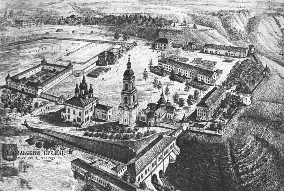
Fig. 1 . General view of the Tobolsk Kremlin from the southeast. 1962. Drawing from the sketchbook of F.G. Dubrovin (TM-15849 / 51).
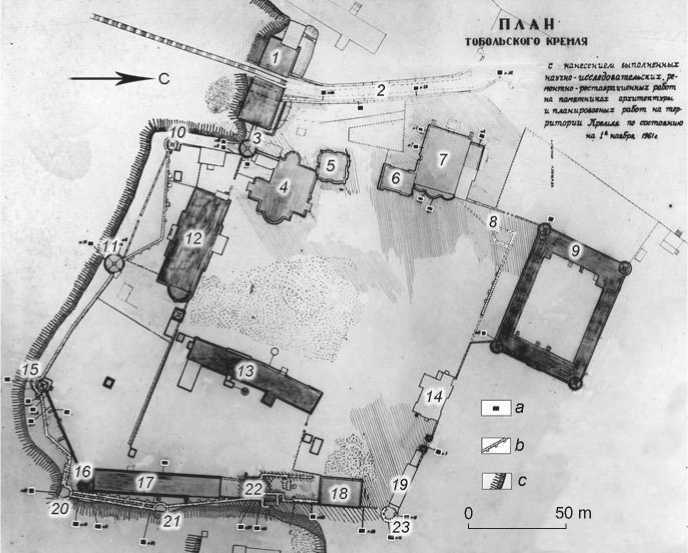
Fig. 2 . Ground plan of the Tobolsk Kremlin of November 1, 1961 (TM-15849 / 15), supplemented by the conventional symbols.
-
1 – Rentereya; 2 – Pryamsky Driveway;
-
3 – Pavlinskaya Tower; 4 – Protection Cathedral; 5 – bell tower; 6 – sacristy; 7 – St. Sophia-Dormition Cathedral; 8 – foundation of the northwestern square tower; 9 – Gostiny Dvor; 10 – southwestern pavilion; 11 – southern round tower; 12 – Bishop’s House;
13 – Consistory; 14 – Bishop’s Guesthouse; 15 – southeastern pavilion; 16 – southeastern corner tower;
17 – Bishop’s stables; 18 – Monks’ dormitory (Church Readers School); 19 – building for baking prosphoras; 20 – foundation of the southeastern Krasnaya Tower; 21 – foundation of the eastern round tower; 22 – eastern square tower with extensions; 23 – northeastern Orlovskaya Tower.
a – excavation pits; b – identified objects; c – boundary of the ravine.
awaiting restoration. For example, the building of the Gostiny Dvor, St. Sophia Cathedral, the Bishop’s stables, and the supporting walls of the Pryamsky Driveway were investigated in this manner. One can get some idea of these works from the photographs showing the exposed sections of stonework in the apses of St. Sophia Cathedral (Fig. 3). One exception included some test pits made along the eastern part of the fortress wall, where tremendous work was carried out to identify the lost objects.
A peculiarity of the restoration work carried out by Dubrovin was that he did not try to restore only one building or a group of scattered buildings. His main task was to create a single architectural complex, where each component would harmoniously complement the others. Therefore, the architect allowed for the construction of newly built replicas as close as possible to the appearance of old originals. This required additional research. The situation with the defense walls, without the restoration of which the Tobolsk Kremlin could hardly look like a Kremlin, was particularly alarming. For this reason, as early as 1957, an impressive study of the contours of the former fortress walls was performed (Kochedamov, 1963: 144). The work in these areas, which can be called archaeological by the standards of that time, were carried out with the partial removal of soil in order to find and unearth the foundations and, accordingly, establish their location and general layout. It should be clarified that until recently, archaeological sites of the 17th century were often perceived as an unimportant part of the cultural and historical heritage; professional archaeologists rarely showed interest in them, and architectural works were carried out without properly organized excavations.
Today, the northern boundary of the Sofia courtyard is formed by a fence (mid-18th century), including the Holy Gates, the Episcopal Guesthouse (early 20th century), and the southern wall of the Gostiny Dvor (early 18th century). In this area, in the northwestern corner of the Sofia courtyard, the remains of a square tower of the late 17th century and the adjacent foundation of the fortress wall were found (see Fig. 2, 8 ) (Kirillov, 1984: 83). This feature was known from the written and cartographic sources. The northern side of the tower was along the same line as the defensive wall, which is confirmed by ground plans of the Troitsky promontory of the 18th century. This is somewhat surprising. According to traditional planning, a tower should have protruded beyond the line of walls, so the defenders of the fortress could execute flanking fire. According to the drawing by Dubrovin, the northern defense wall had small protrusions on the inside—obviously, the supports of the wall arches, above which a shooting gallery was once located. This may indicate that during the construction of the northern
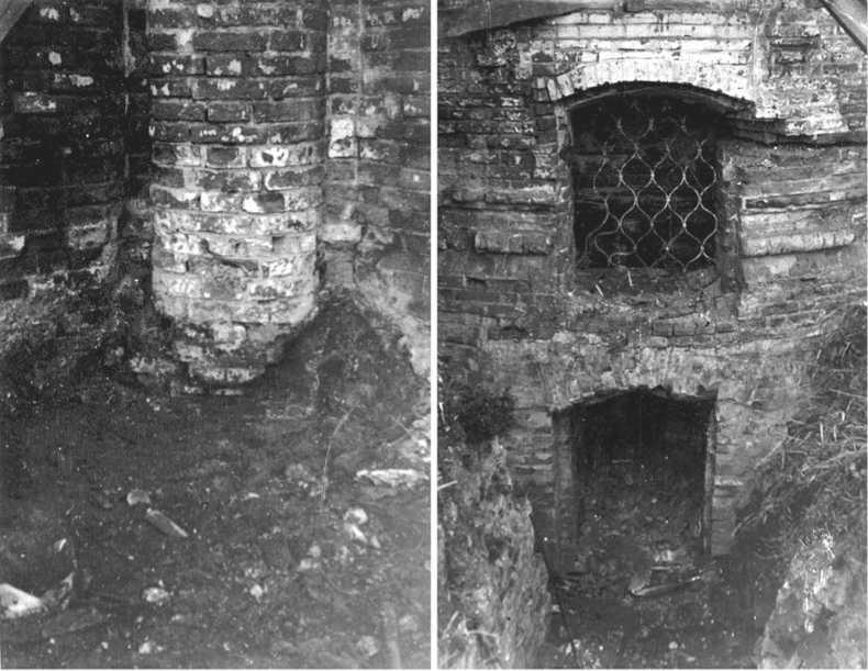
Fig. 3 . Unearthed foundations of the apse of St. Sophia-Dormition Cathedral. View from the east (TM-15849 / 35).
part of defensive structures, they were given a guarding and combat function. Similar arcades are known from the other parts of the defense walls, where they survived until the mid-20th century.
In 2000, A.A. Adamov (2001: 7–10) investigated the ruins of the northwestern square tower. The remains of its foundation lay immediately below the sod layer. It is possible that the upper layers of building debris were removed in the mid-20th century (Balyunov, Danilov, 2017: 9, ill. 1). As far as one can judge, Dubrovin treated the object of architectural heritage and its cultural layer with sufficient care, which cannot be said about construction and beautification work conducted on this territory in subsequent periods. Unfortunately, Dubrovin did not perform the conservation of the objects discovered in that area and, according to the preserved records, their restoration was also not planned.
The area where the western part of the defensive structures was once located was fairly densely built up in the 18th century (sacristy, Protection Cathedral, bell tower, etc.), which somewhat narrowed Dubrovin’s field for activities. The only structure of the late 17th century in that area was the Pavlinskaya Tower (see Fig. 2, 3), which, as was believed, was preserved in the shortened form (however, it must be said that Dubrovin considered the possibility of restoring the once dismantled upper level of the machicolation). The earthwork was carried out at some distance from that building. The section of the defensive wall between the Pavlinskaya Tower and the Rentereya building is not indicated on the ground plan as an identified object. The photographs taken before the restoration reveal the ruins of this wall (Fig. 4, 2). Their unearthing made it possible to obtain interesting data. The Rentereya is located in the gorge of the Pryamsky Driveway, and in daylight the surface sharply inclines in the direction from the tower towards the building. When this area was cleared of the later layers, it turned out that the fortress wall there had two levels of blind arcades, in fact representing two rows of supporting arches placed one upon the other (Fig. 4, 1) (Kirillov, 1984: 90–91). By the time of the research, the upper row had practically not survived; it was restored thanks to the work carried out by Dubrovin (Fig. 4, 3, 4) (Barabanova, 1986: 105). The unearthed supporting arches of the lower level obviously served as models for restoring some of the remaining sections of the fortress walls, while in that area they were later conserved by a layer of new brickwork.
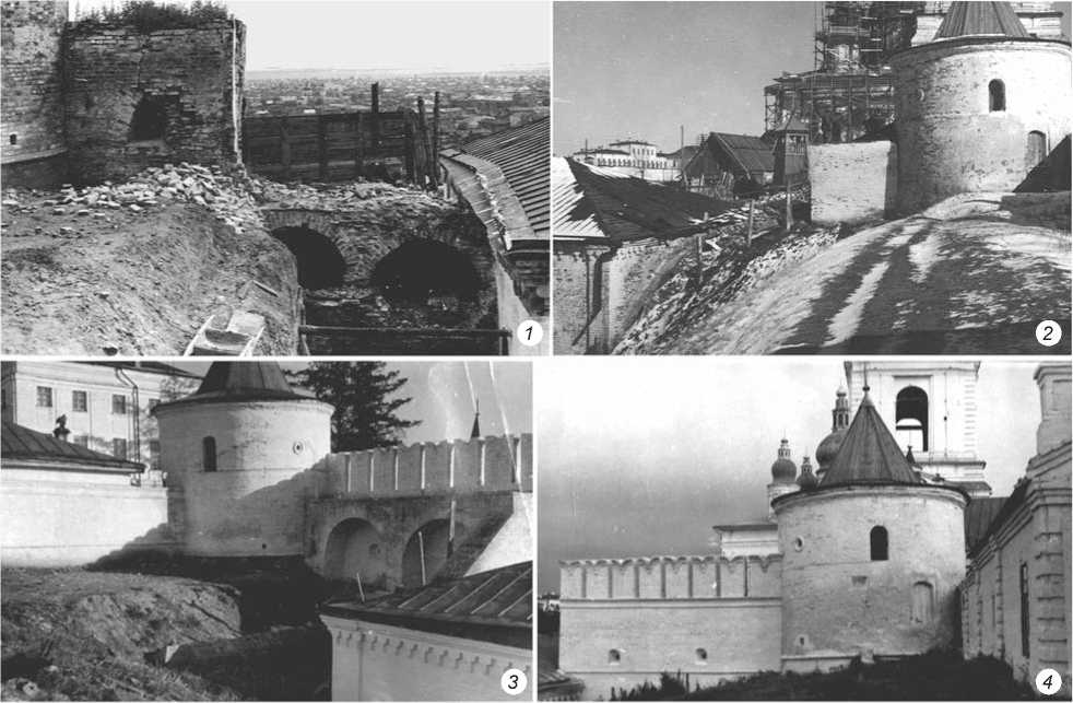
Fig. 4 . Wall between Pavlinskaya Tower and Rentereya (TM-15849 / 60; TM-15849 / 76).
1 – view of the open lower level of the wall-supporting arches from the north; 2 , 4 – view from the south before ( 2 ) and after ( 4 ) the restoration; 3 – view from the northwest after the restoration.
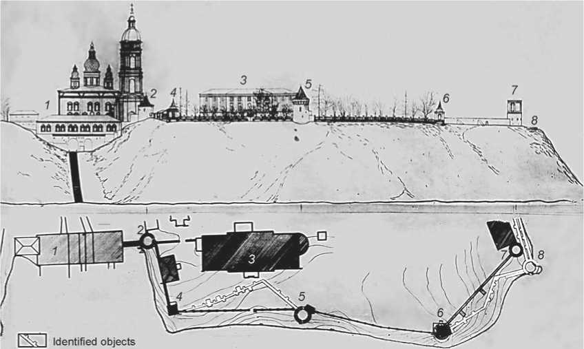
Fig. 5 . Southern part of the military defenses in the Tobolsk Kremlin: general view and ground plan (TM-15849 / 58).
1 – Rentereya; 2 – Pavlinskaya Tower; 3 – Bishop’s House; 4 – southwestern pavilion; 5 – southern round tower; 6 – southeastern pavilion; 7 – southeastern corner tower; 8 – foundation of the southern Krasnaya Tower.
The sketchbook contains a photocopy of the drawing “General view of the Kremlin from the southern side” (Fig. 5). The drawing clearly shows four towers, connected by lines of fences, which to a considerable extent represented wooden planks set between the stone supports on the stone foundation. This fence, similar to some of the towers shown in the drawing, was a late alteration from the 18th–19th centuries. This situation could not satisfy Dubrovin, who wanted to reconstruct the grand Kremlin ensemble; and therefore, the architect did excavation works for searching and exploring the original fortifications. It is known that the monumental Faceted Tower was built on the southwestern corner in the late 17th century, and existed there until about the mid-18th century (Kozlova-Afanasieva, 2008: 113). Considering the threat of collapse, it was disassembled and moved to the northeast, where it was subsequently rebuilt several times (Zavarikhin, 1987: 83). Later, a small square tower was built on the southwestern corner, which in its design resembles a decorative pavilion more than a defensive structure (Fig. 5, 4 ). If ground plan of 1961 is accurate, a powerful foundation was found below this late building (see Fig. 2, 10 ), although it is absent from the drawing showing the Kremlin from the south. According to one of the surviving restoration projects, Dubrovin planned to rebuild the Faceted Tower, but this plan remained only on paper.
Until the mid-1950s, the fence made of planks on stone supports stood in a straight line between the southwestern pavilion and the southern round tower. Dubrovin’s research in the adjoining area revealed the remains of the original defense walls, which had a different configuration in plan view, in the form of a broken line facing north with its angle (see Fig. 5). Protrusions were discovered on the inside of the wall base, which were obviously the supports of the wall arches, although some of them should be identified as the bases of buttresses supporting the fortress walls, the more so because in the drawing, such protrusions were also indicated on the outside of the defense line. Later, the plank fence was dismantled, although Dubrovin took measures to conserve its foundation (more precisely, according to some sources, this foundation was originally that of the southern wall of the Bishop’s House, the construction of which in the mid-18th century led to the destruction of the old fortress wall). It can be argued that excavations revealed the exact location of defenses in that area and established their structural features. This served as a basis for reconstruction, and a new wall was built on the old foundation of the late 17th century, which stands until this day.
Another feature of the southern curtain wall, which underwent repeated alterations, was a tower rebuilt in the late 19th century and turned into a decorative southeastern pavilion square in plan view (see Fig. 2, 15 ). In the late 17th century, a round tower was in this place (Kozlova-Afanasyeva, 2008: 114). The surviving plans and photographs show that below the pavilion, Dubrovin
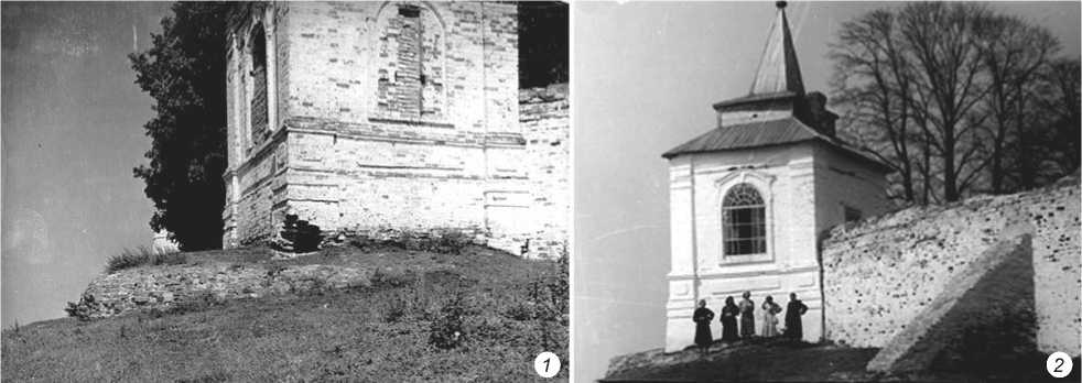
Fig. 6 . Southeastern pavilion built on the foundation of the round tower (view from the southeast) before (1) and after (2) the restoration (NV-2211 / 11, NV-2211 / 39).
discovered at least two foundations one on top of the other (see Fig. 5, 6 ; 6). Recent excavations confirm this quite confidently; therefore, that object was rebuilt twice (Balyunov, Danilov, 2017: 9–10, ill. 4). The lower round foundation can be examined today because it was partially conserved under new stonework. Judging by the project records, Dubrovin considered it appropriate to rebuild an impressive round tower there, especially since the excavations established its dimensions quite accurately.
As it turned out from the work, the fence in the area between the southern round tower and southeastern pavilion (see Fig. 5, 5 , 6 ) stood on the foundation of the old defense wall. Therefore, a reconstruction was carried out there, and a new structure with powerful supporting arches in the lower level was built. A much more complex situation occurred in the area adjacent to the southeastern corner of the fortifications. The remains of the Krasnaya (‘beautiful’) old tower were studied there, at the very edge of the terrace (see Fig. 5, 8 ; 7, 1 ) (Kirillov, 1984: 79). It is known that the Krasnaya Tower was disassembled when the threat of its slipping into ravine appeared. It is believed that in the late 18th century, a new southeastern corner tower, which received a “lightened” pavilion form, was built in a new place inland from the edge of the terrace instead of that structure (Kozlova-Afanasieva, 2008: 114). For this reason, fortifications of the southern curtain wall were rebuilt there at least twice. The later wall with two buttresses had survived by the time of Dubrovin’s work, and was located in a straight line between two southeastern towers (see Fig. 5, 6 , 8 ). The foundation of the old wall was discovered by the excavations. It had a zigzag shape on the map, which looked even more sophisticated owing to numerous protrusions from both external and internal sides, which were obviously the remains of the supports of wall arches and buttresses (Kirillov, 1984: 79). Owing to its extremely dangerous proximity to the edge of the terrace, it was not possible to rebuild the old buildings.
Therefore, in the 1950s–1960s, restoration work in that area was carried out on the existing later objects— a section of the wall and southeastern corner tower.
The eastern curtain wall of the original fortifications was preserved quite fragmentarily. Today, two buildings of the late 18th century (the Bishop’s stables and monks’ dormitory) and newly rebuilt towers (square tower and round Orlovskaya Tower) stand along this line (see Fig. 7). Opposite the Bishop’s stables, on the edge of the terrace, Dubrovin discovered the foundation of another round tower, now unknown (see Fig. 7, 4 ). One interesting find was the remains of defense walls between that tower and southeastern Krasnaya Tower (see Fig. 7, 1 , 4 ). Two almost parallel lines of foundations were discovered there; each one had the protruding bases of the supports of wall arches on the inside (Ibid.). This fact may have several explanations. First, the fortification wall in this section was initially more structurally sophisticated than the wall in other places, and could have included the interior rooms of the lower gallery. Second, the defenses there were rebuilt at least twice. In this case, an extension to the fortress wall could have been made for creating lower rooms (for example, monastic cells), or due to the threat of collapse, the wall could have been completely dismantled and rebuilt with minor changes. Study of the available cartographic evidence shows that the latter is more likely.
Relatively large-scale work was performed north of the Bishop’s stables for establishing the initial location and structural features of the eastern square tower (see Fig. 2, 22 ; 8, 1 ). Excavations revealed that this structure, which was built in the late 17th century, was later dismantled owing to the threat of its collapsing into ravine, and was rebuilt on a larger scale, with a shift to the southwest, while a section of the fortification wall became its facade (Kirillov, 1984: 82). The square tower underwent significant alteration in the last quarter of the 18th century, when its surviving parts were combined with
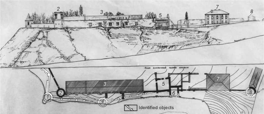
Fig. 7 . Eastern part of the military defenses in the Tobolsk Kremlin: general view and ground plan (1958) (TM-15849 / 55).
1 – foundation of the southeastern Krasnaya Tower; 2 – southeastern corner tower; 3 – Bishop’s stables; 4 – foundation of the eastern round tower; 5 – eastern square tower of the 18th century; 6 – eastern square tower of the late 17th century; 7 – Monks’ dormitory;
8 – ruins of the northeastern Orlovskaya Tower.
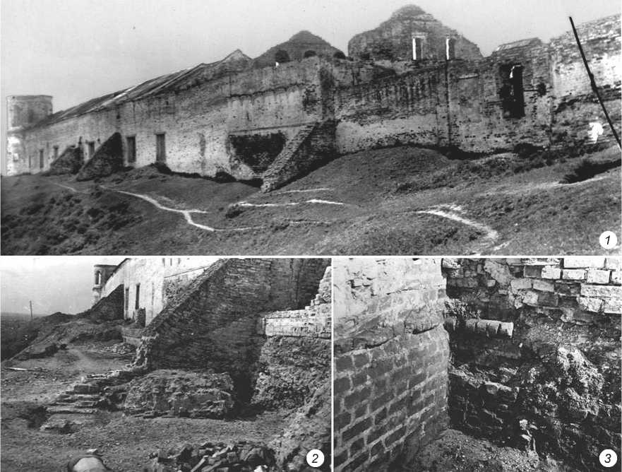
Fig. 8 . Eastern square tower.
1 – general view from the northeast, 1952 (TM-15849 / 2); 2 – excavation of the foundation (view from the northeast), 1959 (TM-15849 / 3); 3 – unearthed foundation (view from the southeast?), 1958 (TM-15849 / 3).
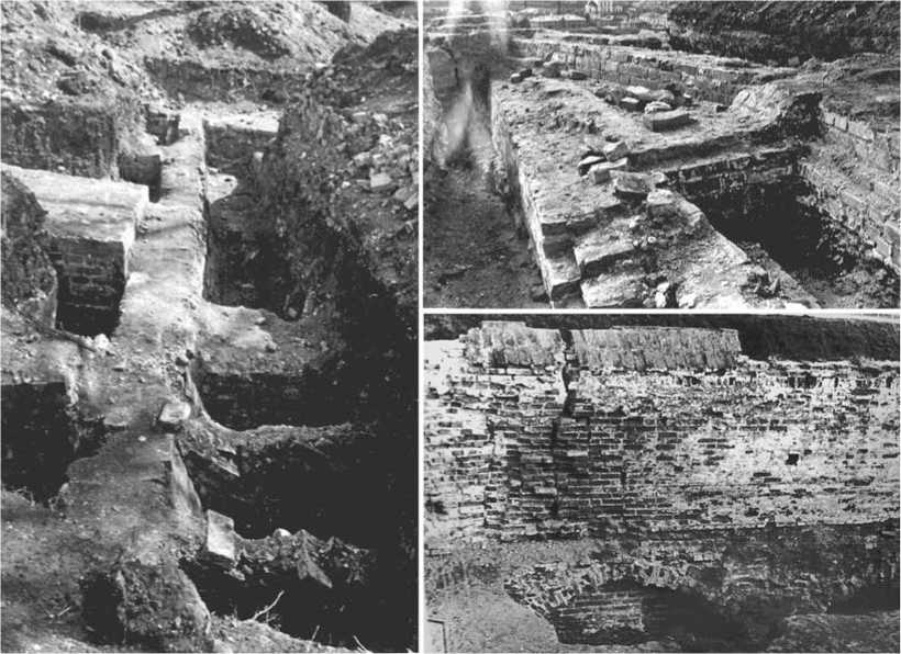
Fig. 9 . Unearthed foundations of the fortress walls (TM-15849 / 44; NV-4282 / 13).
the building of the Bishop’s stables (Kozlova-Afanasieva, 2008: 114). In this area, Dubrovin discovered the only section of the defense wall with the surviving battlements of the upper machicolation (see Fig. 7, 5 ). Kochedamov gave such a description: “By now, only its small section built into the square tower of the eastern wall has survived. This wall was approximately 1.8 m wide at the lower part and was approximately 9 m high (with battlements). At present, the level of the ground near the wall has risen, but during the excavations, three powerful arches supporting it were found at the depth of 3.5 m. However, this is a special case, as the main wall was more modest in size” (1963: 34) (Fig. 9). Notably, precisely this find served as a model for restoring the upper battlements of the fortress wall around the Sofia courtyard, where they were absent (Barabanova, 1986: 103).
A powerful buttress was located on the outside of the wall. Studying it helped to establish the initial layout of the square tower of the late 17th century (see Fig. 8, 2). Excavations unearthed a brick band located at the level of the lower machicolation at the base of this structure (Ibid.: 104) (see Fig. 8, 3). Further work revealed that the buttress belonged to the southern wall of the original tower. Thus, the location of its foundations was established fairly accurately. It was not possible to restore this object in its original form, since “the walls of the tower were fastened by steel binds, which saved them from the incipient intense destruction” (Kochedamov, 1986: 144). A later square tower, with a fragment of the defense wall built into it, was recreated under the supervision of Dubrovin. At the same time, the ruins of the round Orlovskaya Tower were studied (see Fig. 7, 8) in the northeast corner of the Sofia courtyard, and the tower was subsequently rebuilt.
Conclusions
Summarizing all of the above, it can be concluded that the most important outcome of the work carried out under Dubrovin’s supervision was the study of military defenses. As Kochedamov observed, “the excavation established their former position and structures, which made it possible to make an accurate reconstruction of the walls and towers of the Kremlin in the part of St. Sophia’s courtyard” (1963: 144). Notably, these are the only stone fortifications in Siberia, built in the late 17th century. They survived in fragmented form. Obtaining detailed information about their structures, remodeling, and locations today can only be done with the help of archaeological sources, which in our case are represented by the photographs from the excavations by Dubrovin in the 1950s. This heritage reflects a part of the processes that were taking place in the Soviet Union in the first post-war decades. Extensive restoration work began in 1950s–1960s at the monuments of the Pskov, Rostov, Nizhny Novgorod, Astrakhan, Tula, Ryazan
Kremlin, etc. Like in Tobolsk, much of this work was carried out according to Central Scientific and Restoration Workshops projects.
