
Assessment of Transport Infrastructure Provision in the Russian Arctic Zone
Journal: Arctic and North @arctic-and-north
Section: Social and economic development
Article in issue: 63, 2026.
Free access
The significant heterogeneity in the development of Russian regions in many parameters (population density, standard of living, provision of infrastructure) is most clearly evident in the Arctic territories. Ensuring the unity of economic space is both an important and complex task for these territories. This pa-per examines the provision of transport infrastructure and the structure of transport modes in the Arctic zone of the Russian Federation. A range of scientific methods was applied to determine the characteristics and features of the spatial organization of transport infrastructure: a systems approach and methods of comparative analysis, hierarchical cluster analysis, k-means cluster analysis and a cartographic method. Considering that territorial differentiation manifests itself at both the regional and municipal levels, the corresponding characteristics of transport systems were examined. From a methodological perspective, the authors propose a scientific approach based on the methods listed above for obtaining knowledge about the objects under study, the application of which allows for a comprehensive assessment of the Arctic Zone of the Russian Federation in terms of transport infrastructure provision. The results of the study demonstrate significant spatial heterogeneity and structural variability in transport infrastructure provision indicators for the territories under study. Furthermore, it was determined that the levels of transport infrastructure provision across different modes of transport for the study area are significantly lower than the national average for Russia. In practice, the obtained results can be used as an information base for identifying structural and spatial problems of transport and logistics systems in Arctic territories and for providing the necessary scientific justification for management decisions aimed at transforming them.
Short address: https://sciup.org/148333993
IDS: 148333993 | UDC: [332.1+338.47](985)(045) | DOI: 10.37482/issn2221-2698.2026.63.29
Text of the scientific article Assessment of Transport Infrastructure Provision in the Russian Arctic Zone
DOI:
Arctic Zone. Arktika i Sever [Arctic and North]. 2026; 63: 29–46. This work is licensed under a CC BY-SA License
Regional transport systems ensure the connectivity and unity of the country’s economic space. The level of transport provision and the structure of transport systems in regions and municipalities by mode of transport vary significantly across the Arctic zone of the Russian Federation. This is due to both socio-economic and geographic specifics. Moreover, the transport sector is one of the most climate-dependent. The territory of our country is located in the arctic, subarctic, temperate and subtropical zones, which is a source of increasing differentiation in the level of provision of transport infrastructure and the composition of transport modes (Serova, Serova, 2021; Kuznetsova, Vasilyeva, 2024; Gruzinov, Zvorykina, Ivanov et al., 2019). Transport infrastructure includes highways, railways, airports, heliports, and river and sea ports. The level of transport infrastructure provision affects the possibilities of organizing and the volumes of freight and passenger transportation. In areas with a harsh climate, sparsely populated areas, and low population density, there are low levels of transport infrastructure provision and the exclusion of certain modes of transport from transport systems. Such areas include the Arctic Zone of the Russian Federation (AZRF), the largest part of which is located above the Arctic Circle. At the same time, Russia’s Arctic territories make up approximately one-third of the country’s area and are home to 2% of the population 1. Moreover, 80% of Russia’s gas and 10% of oil are produced in the Arctic 2. The continental shelf of the Russian Federation in the Arctic, according to expert estimates, contains more than 85.1 trillion m3 of combustible natural gas, 17.3 billion tons of oil (including gas condensate), and is a strategic reserve for the development of the Russian Federation’s mineral resource base in the AZRF. Furthermore, the “Arctic lifeline” — the Northern Sea Route (Popova, 2012) — runs along the northern borders of the AZRF, and its economic and strategic significance is only increasing in the current geopolitical environment.
Considering the above, as well as the existing contradiction between the concentration of economic activity and the need to distribute it spatially, including for the purpose of aligning socio-economic development indicators, the need to ensure the scientifically sound development of transport systems in the Russian Arctic is becoming increasingly urgent, taking into account socioeconomic and geographical characteristics and the corresponding localization of the productive forces of the national economy. There is a need to assess the existing transport system in the territories of the Russian Arctic. To achieve this aim, the study evaluates the availability of transport infrastructure both overall and by mode of transport (road, air, water and rail). The study suggests that the AZRF is characterized by significant (more pronounced than across Russia as a whole) differentiation in the availability of transport infrastructure at both the regional and municipal levels, due to economic and climatic factors. Furthermore, the territories of the AZRF also differ significantly in terms of the composition of their transport infrastructure. Due to the significant geo-
SOCIAL AND ECONOMIC DEVELOPMENT
Anastasia V. Vasilieva, Ksenija E. Sedova, Alina A. Larina. Assessment of Transport … graphical size of the Arctic territories, the analysis was conducted at both the regional and municipal levels, allowing for greater specificity.
Literature review
The connectivity of economic space is a relevant area of research in Russian science due to the vast size of our country and the significant heterogeneity in the development of its territories across numerous indicators, including population density, infrastructure provision and the standard of living. Traditionally, the economic connectivity of territories is understood as the level of interaction potential in various spheres of the national economy (social (Demidova, Kayasheva, Demyanenko, 2021), information and communications (Blanuţa, 2018), transport (Gumenyuk, Gumenyuk, 2021), etc.). In turn, these interactions ensure the integrity and development of the national economy, contribute to the reduction of interregional inequality (Kryukov, Kolomak, 2021), and serve as a basis for the expansion of domestic markets (Kotov, 2021).
One of the key aspects attracting research interest is the differentiation of territories according to a particular parameter, a set of parameters, or an integral indicator (Nefedova, Trey-vish, Sheludkov, 2022; Kramin, Ustyuzhanina, 2024; Lavrikova, Suvorova, 2023; Suspitsyn, 2022). However, differentiation in itself is not particularly noteworthy. It is important to understand the influence of spatial heterogeneity on the development of economic systems and society as a whole. It is worth citing some studies which show that a high degree of differentiation acts as an objective prerequisite for a certain influence on the pace of national economic development (Nefedova, Streletsky, Treyvish, 2022; Kryukov, Seliverstov, 2022; Druzhinin, 2022). These results of Russian scientists correspond with the scientific approaches of foreign economists who study the inequality of economic space, including in the regional aspect (De Dominicis, 2024; Panzera Postiglione, 2021; Ganau, Kilroy, 2022), which aligns with the most popular theories of spatial development of economic systems by P. Krugman (Krugman, 1991) and M. Porter (Porter, 1998 ).
Taking into account the unique geographical characteristics of the Russian territory, the works focusing on Russian specifics are of the greatest interest within the scope of this study. The issue of spatial development in the works of Russian specialists is also revealed through studies of the localization of the main productive forces, including transport networks. Within the framework of this study, we present the results of works that examine the spatial aspects of the development of transport infrastructure, including in Arctic territories. In one of these studies, specialists from the Laboratory of Territorially Economic Structures of the Pacific Geographical Institute of the RAS studied the development and formation of the transport system of the Far Eastern region (Baklanov, Moshkov, Tkachenko et al., 2023). This vast Russian territory is characterized by a significant influence of natural and climatic conditions on the development of transport: mountainous terrain, harsh climate, difficult navigation conditions. The work substantiates the socioeconomic and geopolitical significance of the region’s transport network. From the perspective of spatial organization, patterns of development have been identified that demonstrate the interre- lationship between climatic parameters and the level of diversification of the transport system by mode. The study by specialists from the Kola Science Center also shows the specifics of transport system development in the special natural and climatic conditions of the Arctic. The authors conclude that the system is underdeveloped and that the restoration of year-round navigation along the Northern Sea Route is necessary for the formation of a unified transport system in the Arctic (Serova, Serova, 2019). The study by specialists from the P.I. Melnikov Permafrost Institute of the SB RAS and the M.K. Ammosov North-Eastern Federal University revealed the specifics of transport infrastructure design and construction, as well as the impact of seasonal temperature fluctuations and soil thawing on the foundations of motorways (Galkin, Plotnikov, Pankov, 2023).
The role of transport in the socio-economic development of Arctic territories is also being studied quite extensively. For example, limitations in transport connectivity are most acutely felt against the backdrop of socio-economic problems in remote Arctic settlements (Nenasheva, Grishchenko, 2023). A crisis affecting one mode of transport impacts the efficiency of the transport system in Arctic territories as a whole (Gorbunov, 2022). Furthermore, poor transport accessibility reduces the quality of life for the population, for example, in terms of access to basic healthcare services (Dmitrieva, 2023).
It is noteworthy that the Arctic region of the Russian Federation is regarded as a large-scale macro-system characterized by significant territorial differentiation at both regional and municipal levels. At the same time, the basic laws of spatial economic modelling are applied there; the essence of these laws is that the objects under study cannot be considered in isolation, as they interact, and these interactions may result in the redistribution of economic characteristics across space (Elhorst, 2024).
Research methods
The choice of methods for this study is determined by the interdisciplinary nature of the field of spatial economics. To achieve the aims and objectives of the study, a range of scientific methods were employed: a systems approach and comparative analysis methods, hierarchical cluster analysis, k-means cluster analysis, and a cartographic method.
Let us describe the methodological tools used in detail. Municipal entities of the Arctic Zone of the Russian Federation were analyzed. Generalized regional indicators were also considered. It should be noted that the studied regions are located both fully and partially within the Arctic zone, which was also taken into account in the analysis. The municipal entities under study can be conditionally divided into groups based on the established system of territorial organization of local self-government: urban okrugs, municipal districts, okrugs, uluses, etc. This division was also taken into account in the study.
Six municipalities were excluded from the analysis, as the statistical authorities do not provide data for them due to the special regime of secure operation and protection of state secrets in
SOCIAL AND ECONOMIC DEVELOPMENT
Anastasia V. Vasilieva, Ksenija E. Sedova, Alina A. Larina. Assessment of Transport … force in their territory, which also includes special living conditions for citizens (closed administrative-territorial formations in the Murmansk Oblast), were excluded from the analysis.
For each municipality, indicators characterizing the availability of transport infrastructure were determined:
-
• road density (total and local);
-
• presence/absence of rail links to the administrative center of the municipality or region;
-
• concentration of sea and river ports;
-
• concentration of airfields and heliports.
Statistical, departmental, and cartographic data were used to determine these indicators. The most labor-intensive task was determining the total road density, as this indicator takes into account federal, regional, interregional, and local roads within the municipality.
In the first stage of work on the typology of municipal formations based on the density of local roads, a cluster analysis was performed using the k-means method with objective function minimization:
=
∑
∑X ∈ Si ( X - Ш ) i=i
→ min
(1),
where: k- number of clusters, Si - resulting clusters, i=1,2,…,k,and μi - centers of mass of all vectors x in cluster Si.
Subsequently, for a comprehensive assessment of transport systems, a hierarchical cluster analysis was performed, taking into account all the aforementioned indicators. Ward’s method was applied, which results in the minimum increase in variance when merging clusters:
∆=∑ i ( xi - ̅) 2 -∑ Xi ∈ A ( xi - ̅) 2 -∑ Xi ∈ В ( xi -̅)2 (2), where : ¡ – all elements of the considered merging, xi — coordinates of the ¡-th element, x̅ — center of the merged cluster, a̅ — center of the 1st cluster, b — center of the 2nd cluster.
The analysis resulted in the formation of clusters characterizing typological groups based on the characteristics of their transport infrastructure provision. Based on the results of this typology, a schematic map was compiled demonstrating the geography of the identified typological groups. The methodological combination of the results of hierarchical and spatial models can be considered justified in view of the emerging opportunities to identify a broader and more adequate set of tools for spatial and economic development, taking into account the complexity of the spatial organization of regional and municipal economic systems (Timiryanova, Zimin, Yusupov, 2021).
The set of scientific approaches applied to assessing the availability of transport infrastructure in the AZRF is consistent with the information base. The study utilized statistical data from Rosstat (regional and municipal levels), data from the Ministry of the Russian Federation for the Development of the Far East and the Arctic, departmental data from the Federal Agency for Mari- time and River Transport, the Federal Air Transport Agency, as well as information from the websites of the administrations of the municipalities under study.
Research results
As noted above, Arctic municipalities were analyzed in terms of their availability of roads, river and sea ports, airfields, heliports, and rail links. These indicators demonstrate significant spatial heterogeneity. Natural, climatic, and geographic factors influence the spatial organization of road transport infrastructure. Furthermore, road density also depends on the type of municipality. For example, this indicator is highest in urban okrugs, which is consistent with the logic of administrative-territorial division (Table 1).
Table 1
Road density indicators for the AZRF municipalities
|
Indicator |
km per 1 000 km2 |
|
|
1 |
average road density in municipalities of the AZRF regions included in the Arctic zone |
1.73 |
|
2 |
average road density in municipalities of the “urban okrug” type included in the Arctic zone |
6.3 |
|
3 |
average road density in municipalities of the “municipal okrug, district, ulus” types included in the Arctic zone |
1.37 |
|
4 |
average road density in municipalities of the “urban okrug” and “municipal okrug, district, ulus” types in regions fully included in the Arctic zone |
1.76 |
Source: calculated by the authors based on data 3, 4, 5, 6, 7, 8, 9, 10.
Significant heterogeneity was identified among the regions of the AZRF. For example, the availability of roads in the Republic of Karelia is more than 30 times higher than in the Chukotka Autonomous Okrug, and also differs more than 40 times in terms of local roads for the same regions.
To assess the provision of motorways in Arctic municipalities, k-means clustering (Formula 1) was applied; based on the results, all municipalities were divided into four groups according to their level of provision with motorway networks (Table 2).
Table 2
Groups of municipalities by level of road network availability
|
high |
u.o. Murmansk, u.o. Arkhangelsk, u.o. Novodvinsk, u.o. Naryan-Mar, u.o. Gubkin-skiy, u.o. Muravlenko, u.o. Noyabrsk, u.o. Labytnagi, u.o. Novy Urengoy, u.o. Anadyr |
|
above average |
u.o. Severodvinsk, u.o. Salekhard |
|
average |
m.o. Apatity, m.o. Monchegorsk, m.o. Olenegorsk, m.o. Polyarnye Zori, Kostomuksha u.o., Segezhskiy m.o., Mezenskiy m.d., Onezhskiy m.d., Pinezhskiy m.o., u.o. Norilsk |
|
low |
Pechengskiy m.o., Kovdorskiy m.o., m.o. Kirovsk, Kandalakshskiy m.d., Lovozer-skiy m.d., Terskiy m.d., Kolskiy m.d., Belomorskiy m.o., Kalevalskiy m.d., Kemskiy m.d., Loukhskiy m.d., Leshukonskiy m.o., Primorskiy m.o., u.o. Zapolyarny, u.o. Vorkuta, u.o. Inta, u.o. Usinsk, Ust-Tsilemskiy m.d., Beloyarskiy m.d., Berezovskiy m.d., Krasnoselkupskiy m.d., Nadymskiy m.d., Priuralskiy m.d., Purovskiy m.d., Tazovskiy m.d., Yamalskiy m.d., Shuryshkarskiy m.d., Evenkiyskiy m.d., Taimyrskiy Dolgano-Nenets m.d., Turukhanskiy m.d., Abyyskiy m.d., Allaikhovskiy m.d., Ana-barskiy National (Dolgan-Evenki) m.d., Bulunskiy m.d., Verkhnekolymskiy m.d., Verkhoyanskiy m.d., Zhiganskiy m.d., Momskiy m.d., Nizhnekolymskiy m.d., Olenekskiy m.d., Srednekolymskiy m.d., Ust-Yanskiy m.d., Eveno-Bytantayskiy n.m.d., Anadyrskiy m.d., Bilibinskiy m.d., Chukotskiy m.d., u.o. Pevek, u.o. Provi-denskiy, u.o. Egvekinot |
Source: calculated by the authors based on the results of a k-means cluster analysis with objective function minimiza tion and data 11, 12, 13, 14, 15, 16, 17, 18.
Many regions, including those with the lowest levels of provision of this type of transport infrastructure, are characterized by the development of compensatory modes of transport, such as air transport. According to data from the Federal Air Transport Agency, as of the end of 2022, there were 53 civil aviation aerodromes and heliports operating in the Arctic region, which are also distributed geographically fragmentally (Table 3). In addition to quantitative indicators, it is important to note that the quality of the aviation infrastructure, which has been aging for many years, poses significant risks to the development of this mode of transport (Gorbunov, Struchkova, 2023) and requires modernization.
Table 3 Civil aviation airfields and heliports in the regions of the AZRF
-
11 Federal State Statistics Service. Database of Municipality Indicators. Murmansk Oblast. URL: https://rosstat.gov.ru/dbscripts/munst/munst47/DBInet.cgi (accessed 03 February 2025).
-
12 Territorial body of the Federal State Service for the Republic of Karelia. Total length of public roads of local importance for 2022. URL: https://10.rosstat.gov.ru/storage/mediabank/78091.pdf (accessed 03 February 2025).
-
13 Federal State Statistics Service for the Arkhangelsk Oblast and the Nenets Autonomous Okrug. Key indicators of the socio-economic situation of municipalities. URL: https://29.rosstat.gov.ru/main_indicators (accessed 03 February 2025).
-
14 Federal State Statistics Service. Database of indicators of municipalities. Komi Republic. URL: https://rosstat.gov.ru/dbscripts/munst/munst87/DBInet.cgi (accessed 03 February 2025).
-
15 Federal State Statistics Service for the Tyumen Oblast, Khanty-Mansi Autonomous Okrug - Yugra and Yamalo-Nenets Autonomous Okrug. Municipal Statistics. URL: https://72.rosstat.gov.ru/municipal_statistics (accessed 03 February 2025).
-
16 Federal State Statistics Service. Database of Municipality Indicators. Krasnoyarsk Krai. URL: https://rosstat.gov.ru/dbscripts/munst/munst04/DBInet.cgi (accessed 03 February 2025).
-
17 Federal State Statistics Service. Database of Municipality Indicators. Republic of Sakha (Yakutia). URL:
(accessed 03 February 2025).
-
18 Federal State Statistics Service. Database of Municipality Indicators. Chukotka Autonomous Okrug. URL:
(accessed 03 February 2025).
|
AZRF region |
Number of civil aviation airfields and heliports (Arctic part of the region) |
|
Murmansk Oblast |
2 |
|
Republic of Karelia |
0 |
|
Arkhangelsk Oblast |
2 |
|
Nenets Autonomous Okrug |
2 |
|
Komi Republic |
2 |
|
Khanty-Mansi Autonomous Okrug |
1 |
|
Yamalo-Nenets Autonomous Okrug |
11 |
|
Krasnoyarsk Krai |
10 |
|
Sakha Republic (Yakutia) |
14 |
|
Chukotka Autonomous Okrug |
9 |
|
Total in the Arctic part of the AZRF |
53 |
|
Total in Russia |
233 |
Source: determined by the authors based on data 19,* for some airports, only approximate passenger turnover figures are available 20
A key geographical feature of the Arctic territories is their coastal location. The development of the Northern Sea Route, which is also associated with the development of water transport in the regions, is of strategic importance. According to the registers of the Federal Agency for River and Maritime Transport, there are 29 river and sea ports located in the Arctic territories (Table 4). One of the targets of the National Project “Efficient Transport System” is the increase in freight traffic volume in the Northern Sea Route to 109.1 million tons 21.
Table 4
River and seaports in the AZRF
|
Region |
Number of river and seaports (Arctic part of the region) |
|
Murmansk Oblast |
0/3 (Vitino, Kandalaksha, Murmansk) |
|
Republic of Karelia |
2 (Nadvoitsy, Segezha)/0 |
|
Arkhangelsk Oblast |
1 (Arkhangelsk)/3(Arkhangelsk, Mezen, Onega) |
|
Nenets Autonomous Okrug |
0/3 (Amderma, Varandey, Naryan-Mar) |
|
Komi Republic |
0/0 |
|
Khanty-Mansi Autonomous Okrug |
0/0 |
|
Yamalo-Nenets Autonomous Okrug |
4 (Labytnagi, Nadym, Salekhard, Urengoy)/0 |
|
Krasnoyarsk Krai |
0/4 (Dikson, Dudinka, Igarka, Khatanga) |
|
Sakha Republic (Yakutia) |
3 (Belogorsk, Zyryanka, Nizhneyansk)/1(Tiksi) |
|
Chukotka Autonomous Okrug |
0/5 (Anadyr, Beringovskiy, Pevek, Provideniya, Egvekinot) |
|
Total in the Arctic part of the AZRF |
10/19 |
|
Total in Russia |
117/65 |
Source: determined by the authors based on data 22 .
Railway density remained unchanged across all Arctic regions from 2010 to 2021. The highest density is recorded in the Republic of Karelia — 123 km of railroad per 10,000 km² of territory. For the Komi Republic, Arkhangelsk Oblast, and Murmansk Oblast, the density ranges from 60 to 40 km of railroad per 10,000 km² of territory. In Krasnoyarsk Krai, the Yamalo-Nenets Autonomous
Okrug, and the Sakha Republic (Yakutia), the density is 9.6 and 3 km of railroad per 10,000 km² of territory, respectively. The Nenets and Chukotka Autonomous Okrugs are not served by rail transport. In order to analyze rail transport provision in greater detail, including at the municipal level, an indicator of the presence or absence of rail links was determined for each Arctic municipality. For this purpose, the Russian Railways train ticketing service and other similar services were used. Table 5 presents a list of municipalities with rail service. The remaining municipalities do not have this service. Although in some cases, such as in the city of Norilsk, limited rail access is provided for freight transport. It is also worth noting that for certain municipalities, such as Kirovsk or Salekhard, rail services are provided via nearby settlements — Apatity and Labytnagi respectively.
-
Table 5
List of the AZRF municipalities served by rail transport
|
Region |
List of municipalities |
|
Murmansk Oblast |
u.o. Apatity, u.o. Olenegorsk, u.o. Polyarnye Zori, Kandalakshskiy m.d., Kolskiy m.d., u.o. Murmansk |
|
Republic of Karelia |
u.o. Kostomukshskiy, Belomorskiy m.o., Kemskiy m.d., Loukhskiy m.d., Segezhskiy m.o. |
|
Arkhangelsk Oblast |
u.o. Arkhangelsk, u.o. Severodvinsk, Onezhskiy m.d., Pinezhskiy m.d., Primorskiy m.d. |
|
Komi Republic |
u.o. Vorkuta, u.o. Inta, u.o. Usinsk |
|
Yamalo-Nenets AO |
u.o. Labytnangi |
The indicator for railway transport provision was included in the system of indicators used for typology, based on the results of hierarchical cluster analysis (Formula 2). In the next stage of the work, to comprehensively assess the availability of transport infrastructure in the Arctic territories based on the results of the hierarchical cluster analysis, a typology was developed taking into account the indicators described above (density of federal, regional, interregional, and local highways, the presence or absence of rail service, the concentration of sea and river ports, and the concentration of airfields and heliports). Seven groups of the AZRF municipalities were identified, considering the level and specifics of transport infrastructure availability, including by mode of transport (Table 6).
-
Table 6 Groups of the AZRF municipalities by level and specific characteristics of transport infrastructure provision
Group
Group composition
1
Zhiganskiy m.d. (RS), Olenekskiy m.d. (RS), Chukotskiy m.d. (ChAO), Purovskiy m.d. (YaNAO), Eveno-Bytantayskiy n.m.d. (RS), Krasnoselkupskiy m.d.
(YaNAO), Tazovskiy m.d. (YaNAO), Beloyarskiy m.d. (KhMAO), Allaikhovskiy m.d. (RS), Momskiy m.d. (RS), Anabarskiy n.m.d. (RS), Ust-Yanskiy m.d. (RS), Verkhoyanskiy m.d. (RS), Nizhnekolymskiy m.d. (RS), Srednekolymskiy m.d. (RS), Norilsk u.o. (KK), Pechengskiy m.o. (MO), Kirovsk u.o. (MO), Monchegorsk u.o. (MO), Leshukonskiy m.d. (AO), Lovozerskiy m.d. (MO), Shuryshkarskiy m.d. (YaNAO), Berezovskiy m.d. (KhMAO), Priuralskiy m.d.
(YaNAO), Ust-Tsilemskiy m.d. (Komi), Terskiy m.d. (MO), Kalevalskiy m.d. (RK), Kovdorskiy m.o. (MO)
2
u.o. Providenskiy (ChAO), u.o. Egvekinot (ChAO), Bulunskiy m.d. (RS), u.o. Pevek (ChAO), Mezenskiy m.d. (AO), Onezhskiy m.d. (AO), Zapolyarny m.d.
(NAO), Taimyrskiy Dolgano-Nenets m.d. (KK)
3
Abyiskiy m.d. (RS), Verkhnekolymskiy m.d. (RS), Nadymskiy m.d. (YaNAO), u.o. Novy Urengoy (YaNAO)
4
Turukhanskiy m.d. (KK), Anadyrskiy m.d. (ChAO), Yamalskiy m.d. (YaNAO), Bilibinskiy m.d. (ChAO), Evenkiyskiy m.d. (KK)
5
u.o. Naryan-Mar (NAO), u.o. Anadyr (ChAO), u.o. Novodvinsk (AO), u.o. Muravlenko (YaNAO), u.o. Noyabrsk (YaNAO), u.o. Gubkinskiy (YaNAO)
6
u.o. Salekhard (YaNAO), u.o. Labytnangi (YaNAO), Segezhskiy m.o. (RK), u.o. Arkhangelsk (AO)
7
Kandalakshinskiy m.d. (MO), u.o. Murmansk (MO), Primorskiy m.d. (AO), u.o. Usinsk (Komi), u.o. Vorkuta (Komi), u.o. Apatity (MO), Belomorskiy m.o. (RK), Pinezhskiy m.d. (AO), Kemskiy m.o. (RK), Kola m.d. (MO), Loukhskiy m.d. (RK), u.o. Inta (Komi), u.o. Olenegorsk (MO), u.o. Severodvinsk (AO), u.o. Polarnye Zori (MO), u.o. Kostomuksha (RK)
Source: determined by the authors based on the results of the hierarchical cluster analysis (Formula 2 for indicators 1, 2, 3, and 4).
The first and largest group includes municipalities with the lowest levels of rail, river, and sea transport. Road density for these territories can be assessed as low or below average. However, the unsatisfactory state of the existing transport network is partially offset by the presence of air service in only half of the municipalities in the group. From a geographical perspective, the group includes territories from all of Russia’s Arctic regions, with the exception of the Nenets Autonomous Okrug. This group is characterized by spatial heterogeneity. The second group in the typology is represented by municipalities with below-average transport accessibility. A distinctive feature of this group is their coastal location and the presence of a seaport, including those located along the Northern Sea Route. The third group includes four municipalities belonging to the Republic of Sakha and the Yamalo-Nenets Autonomous Okrug. This group is characterized by an average to above-average concentration of airports and the presence of river ports, along with the absence of rail service and a low road density. The fourth group is characterized by the highest air travel rates, which can be explained by their geographic location and climate. The fifth group consists of six urban okrugs from the Arkhangelsk Oblast, Nenets, Chukotka, and Yamalo-Nenets Autonomous Okrugs. It is logical that municipalities in this group have a high road density, which is linked to their status as municipalities.
The sixth group, represented by four municipalities, can be considered the best-equipped in terms of transport infrastructure. This group is characterized by an above-average road density, high level of rail service, the presence of river or seaports, and air transport. It should be noted that there is no air service in the Labytnangi urban okrug and the Segezhskiy municipal district. Municipalities in the seventh group are characterized by a low level of transport infrastructure. Such elements as river and seaports (with the exception of the Kandalakshskiy municipal district and the city of Murmansk) and airports are absent in the vast majority of territories. Airports are located in the Primorskiy municipal district and the urban okrugs of Murmansk, Usinsk, Vorkuta, and Apatity. Most municipalities are characterized by low road density (with the exception of urban okrugs). The availability of rail links for all municipalities can be seen as compensating for this situation.
A schematic map has been compiled to demonstrate the geographical distribution of municipalities belonging to typological groups based on the level and specific characteristics of their transport infrastructure provision (Fig. 1).
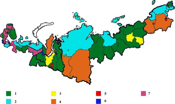
Fig. 1. Schematic map of typological groups of Arctic municipalities based on the specific characteristics of transport system development. The number corresponds to the typology group number in Table 5.
Conclusion
Transport infrastructure ensures the connectivity of geographic and economic space. Moreover, economic diversification occurs more successfully along transport corridors (Pylak, Kogler, 2021). The schematic map presented demonstrates significant spatial heterogeneity in the assessments of transport infrastructure provision in the studied territories. Furthermore, the indicators of provision with various types of transport infrastructure across the studied territory are considerably lower than the Russian average. For example, in the Arctic regions, the road density indicator (federal and local) is approximately half that of the national average or almost equal to it in the areas with the highest level of road coverage (Murmansk and Arkhangelsk Oblasts, the Republic of Karelia), while in the least well-served regions (the Yamalo-Nenets and Chukotka Autonomous Okrugs) this difference reaches 18 and 15 times, respectively. According to data from the register of civil aviation airfields and heliports, 22% of all such facilities are located in the AZRF. Moreover, the highest rates of localization of these facilities are found in regions with the lowest road density. This suggests that climate influences the structure of transport modes, and that aviation acts as a compensatory supplementary mode of transport for these territories. According to data from the Federal Agency for Maritime and River Transport, the Arctic zone accounts for 29.3% of river ports and 8.5% of seaports. Furthermore, a significant proportion of these territories is characterized by structural incompleteness in terms of transport infrastructure, manifested in the absence of one or several modes of transport.
Based on the results of the study and taking into account the specific characteristics of Arctic territories, a number of system-wide measures for transport infrastructure development can be formulated. In order to develop the AZRF transport system and its component transport infrastructure, significant modernization of the existing infrastructure is necessary. This requires conducting an inventory and regular monitoring of the condition of transport infrastructure, as well as introducing new technologies designed for the relevant temperature regimes and other weather conditions. In addition to system-wide measures, it is necessary to intensify the implementation of key Arctic transport projects, such as Belkomur, the Yenisei Meridian, the Northern Latitudinal Passage, Barentskomur, and others. At the same time, individual projects, such as Belkomur, require updating their content due to the changing geopolitical situation. The need to implement the above measures requires a preliminary comprehensive assessment of the availability of transport infrastructure. The authors propose a scientific approach that includes a set of methods, such as hierarchical cluster analysis, k-means cluster analysis, and a cartographic method, the use of which allows for determining the availability of transport infrastructure. In practice, the obtained results can serve as an information base for identifying structural and spatial problems of transport systems in Arctic territories and the corresponding scientific justification for management decisions aimed at their transformation.
