Cave sites of the Jomon period in Taishaku Gorge, Western Japan

Author: Solovyeva E.A., Murakami Y.
Journal: Archaeology, Ethnology & Anthropology of Eurasia @journal-aeae-en
Section: Paleoenvironment, the stone age
Article in issue: 3 т.48, 2020.
Free access
Short address: https://sciup.org/145145505
IDR: 145145505 | DOI: 10.17746/1563-0110.2020.48.3.043-049
Text of the review article Cave sites of the Jomon period in Taishaku Gorge, Western Japan
Taishaku Gorge is one of the most famous canyons in Japan. It is located near the town of Shobara, in the Hiroshima Prefecture, on Honshu Island, and it is a part of the Taishaku National Park. The gorge is a rocky crevice located on a plateau, with a depth of 200–300 m and a length of 18 km, which stretches along the Taishaku River (tributary of the Takahashi River). The canyon is known not only for natural features, but also for archaeological sites dating back to the Paleolithic– the Kofun period. The group of cave sites in the Taishaku Gorge of the Jomon Period is the most numerous in Japan, and its materials provide a wealth of information about the various stages of the existence of human society in this area.
This research is based on published sources, field materials of the study of sites stored in the museums of the Hiroshima Prefecture, as well as the observations of the authors, who took part in the excavations.
The aim of this study is to characterize the sites in the Taishaku Gorge as a special type of archaeological sites,
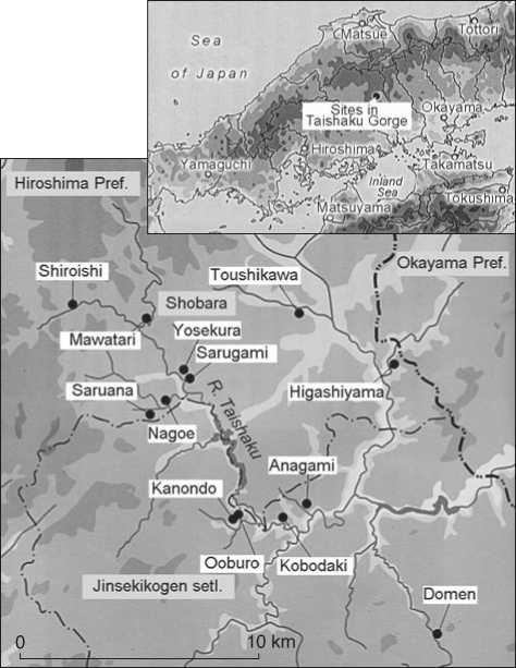
Fig. 1. Cave sites in the Taishaku Gorge (after (Kawase, 2007: Fig. 6)).
and to determine the significance of their materials for studying the early stages of the Jomon Period.
Sites in the Taishaku Gorge were discovered in 1961 during the road construction. In 1977, the University of Hiroshima began to study them. During the archaeological survey of the area, 42 objects were discovered—caves and rocky shelters. The following sites stand out among the archaeological materials: Mawatari, Yosekura, Nagoe, Saruana, Sarugami, Shiroishi, Toushikawa, Higashiyama, Kanondo, Domen, Anagami, Kobodaki, Ooburo (Fig. 1). During the excavation of these sites, fragments of ceramics, stone tools, bone tools, and well-preserved human bones were found. Mawatari and Kanondo are the sites of the Pre-Pottery Period.
Beginning of the Jomon Period* coincided with a warming of climate that caused changes in flora and fauna: large animals became extinct, smaller and faster moving ones appeared, such as wild boar and raccoon dog (see (Kawamura, 1992)). Humans, who were forced to adapt to new climatic conditions, developed new tools. Changes in the toolkit have been recorded starting from layer 4 in the Mawatari rock shelter. At the sites in the Taishaku Gorge, a large number of stone tools with grooves were found: these were sinkers for river nets, which testify to the harvest of fish and shellfish by humans during the Jomon Period. Materials from cave sites allow us to study the transition of the population of the Japanese islands to new forms of adaptation and a change in foraging strategies at the initial and early stages of the Jomon Period.
Special features of the Jomon Period cave sites of the Taishaku Gorge
The formation of caves is associated with the processes of erosion of rocks. River erosion is a phenomenon in which water cuts through rocks, and stones carried by the current break down at the bottom and along the banks of the river, forming rock shelters and caves. Taishaku Gorge is located in a kind of limestone belt in the Chugoku region. Limestone rocks are found in different parts of Japan, in the central part of Kyushu— in the territory from the Kumamoto Prefecture to the Oita Prefecture, on Shikoku Island—from the Ehime Prefecture to the Kochi and Tokushima prefectures. Territory from the Wakayama Prefecture to Nara, Mie, Aichi, and Shizuoka prefectures belongs to the limestone belt. Limestone is also sometimes found in the area from the Fukuoka Prefecture to Yamaguchi Prefecture (Akiyoshido Cave), from Kyoto Prefecture to Shiga and Gifu (Kyugo Cave), Nagano (Natori Cave) and Toyama prefectures. Large cave sites along the Pacific coast in Saitama (Tateya Cave), Tochigi (Oyadera Cave), and Iwate prefectures in Tohoku Region (Ryusendo Cave), Aomori Prefecture (Siriroambe cave) (Watanabe, 2012, 2015). On Hokkaido Island, limestone rocks are concentrated in the area of Hakodate and Abashiri cities (Kawase, 2007: 12).
The archaeological cave sites include the actual caves and rock shelters. The caves are mostly horizontal, with archaeological material found inside the cavity and on the outer terrace. Several walls form a vault; the space along the far wall is usually darkened. The drip line is outside and separates the inside of the cave from the terrace, which is usually larger in area than the interior space. The terrace is usually located sloping towards the valley (Serizawa, 1979).
Rock shelters most often do not have a vault; the rock in the upper part forms an eave. The space under such a canopy looks like this: the inner wall slopes up to 65°, the inner space is small, and the terrace adjoins. The entrance can be of different sizes. For example, in the rock shelters of Yosekura and Mawatari (Taishaku Gorge), the entrances are wide—up to 10 meters. In 50 cave sites of the Incipient Jomon, the entrance is oriented mostly to the south, sometimes to the east, and N-E (Shiraishi, 2015: 4).
The caves change their shapes owing to the natural destruction. Rocks are destroyed by the sun, rain, wind, snow, and falling trees. If cracks form in the soil from the roots of trees, rainwater gets into them and accumulates, which can be one of the destructive factors. Collapses also occur due to earthquakes, landslides, and fires. In some cases, the caves are destroyed, leaving a rocky surface.
The ancient inhabitants of the Japanese islands were settling in caves, because these were cool in summer and warm in winter. Notably, the average annual temperature in the limestone cave is 15–16 °С; it is stable as compared to the annual temperature outside the cave. The humidity is 80–100 % (Shiomi, 1999: 32). The large entrance provided illumination of the front of the cavity. The space in front of the cave was probably multifunctional: it was used for stone processing, making pottery and hunting tools, sorting nuts, etc. The specialization of the small areas of such sites was formed, most likely, in the course of human adaptation to the environment, and not through active change. In the Nagoe rock shelter, traces of a partition were found, which looks like a double fence of a terrace with pillars (Shiraishi, 2015: 6).
In the sediments of the caves, fragments of rock, sand, traces of human activity, including hearths, are found. The filling of the hearths contains coal, ash, and food remnants. The location of objects could change as a result of the influx of large volumes of water, weathering, and temperature changes. In places of temporary use, archaeological finds are scarce. In the cave sites, the stratigraphy of the deposits is clearly visible. Cultural strata are different in thickness; some are very thin, without archaeological remains. Finds are spread through the layers, but may shift. The mixing of materials from the upper and lower cultural layers is possible. This requires a particularly careful approach to the study of the finds.
The drip line, as noted above, divided the cave space into inner and outer zones. In the Initial Jomon, the deceased were buried in the unlit inner space of the caves (Ibid.: 7). It is absolutely certain that the caves were used as burial places in the Late Jomon: in layers 3 and 4 of the Yosekura site, two common graves of adults and children were found. In Fun Cave, Oita prefecture, 66 human skeletons were found; nine of them belong to the Initial Jomon, 40 to the Early Jomon, and 17 to the Late Jomon (Ibid.: 11). Rock cavities were often used for burial. For example, in Tobayama Cave, Nagano Prefecture, a lot of scattered human bones of the Kofun Period* were found; in Oderayama Cave, Chiba Prefecture, there were several wooden coffins. Further research may help to establish whether the caves were used for burial in the Incipient Jomon (Vorobiev, 1958).
It is difficult to determine whether the people of the Incipient Jomon, who began to make pottery, aspired to settled life, since no settlements of this time have been found. In addition to dwellings, people needed various sites for manufacturing stone tools and pottery, assembling and repairing hunting equipment, preserving food made from nuts, carving prey, burying, and conducting ceremonies. These actions, even if they were not performed simultaneously, required certain spaces in front of the cave. In other words, the presence of large terraces was an important condition determining the choice of the cave for living. Similar sites from the Incipient Jomon are found in river valleys. These include the Maeda Kochi cave site near Tokyo, whose inhabitants were most likely engaged in salmon and trout fishing (Shiraishi, 2015: 18). Since the fishing industry is seasonal in nature, it was necessary to preserve the caught fish in order to keep it for a long time. The presence of a cave terrace or open areas on the riverbank was vital (Kawamura, 1988). On the terraces, excavations have uncovered stone tools, pits, and utility sites, dating back to the Incipient Jomon. While exploring Fukui Cave in the Nagasaki Prefecture, on a gentle slope on its southern side, materials from the Paleolithic–Jomon Period were found. Artifacts associated with caves can also be found on rocky surfaces that slope towards the river. Kamikuroiwa rock shelter in the Ehime Prefecture, in Western Japan, is located on the southern slope of a cliff, and has a flat adjacent platform. If earlier research of caves was focused directly on the caves themselves, now the area around them is also actively studied.
Artifacts of the beginning of Jomon Period
The number of cave sites in the Japanese archipelago, which deposits contain a cultural layer of the Incipient Jomon, is small. At the archaeological sites in the Taishaku Gorge, Hiroshima Prefecture, layers of the Paleolithic and the Insipient Jomon have been traced in the caves of Kanondo, Kobodaki, Ooburo, and in the Mawatari rock shelter (see Table ). They contain scarce materials of the Insipient Jomon (Ichikawa, Nagatomo, Hagihara, 1978: 173; Roberts, 1997: 821).
It is difficult to determine exactly how the ancient people used the caves because of the specifics of the sites and the relatively small number of finds. Archaeologists have fully explored only few of them. Analysis of finds from Senpukuji and Fukui caves, in the Nagasaki Prefecture, showed that the amount of pottery there was more than the life of the family requires. In addition, layer 9 at Senpukuji Cave contained 2153 microlithic tools and 162 blanks. Since this cave was used seasonally, it can be assumed that it was a workshop for the manufacture of microlithic tools (Shiraishi, 2015: 13). In the Nagoe rock shelter, in the Taishaku Gorge, the number of utility pits and the area of cave terraces correspond to one or
Chronological attribution of sites in Taishaku Gorge
|
Site |
Paleolithic |
Jomon Period |
Yayoi Period |
|||||
|
Incipient Jomon |
Initial Jomon |
Early Jomon |
Middle Jomon |
Late Jomon |
Final Jomon |
|||
|
Mawatari |
+ |
+ |
+ |
– |
– |
– |
– |
+ |
|
Kanondo |
+ |
+ |
+ |
+ |
+ |
+ |
+ |
+ |
|
Kobodaki |
– |
+ |
+ |
+ |
+ |
+ |
+ |
+ |
|
Domen |
– |
– |
+ |
+ |
– |
+ |
+ |
+ |
|
Ooburo |
– |
+ |
+ |
– |
+ |
+ |
– |
– |
|
Yosekura |
– |
– |
+ |
+ |
+ |
+ |
+ |
– |
|
Nagoe |
– |
– |
+ |
+ |
+ |
+ |
+ |
+ |
|
Shiroishi |
– |
– |
+ |
+ |
– |
+ |
– |
+ |
|
Saruana |
– |
– |
+ |
– |
– |
+ |
+ |
– |
|
Anagami |
– |
– |
+ |
+ |
– |
+ |
– |
– |
|
Sarugami |
– |
– |
– |
– |
– |
+ |
+ |
– |
|
Toushikawa |
– |
– |
+ |
+ |
– |
+ |
– |
– |
|
Higashiyama |
– |
– |
+ |
+ |
– |
+ |
+ |
+ |
two families. Most likely, one family lived in the shelter (Shiomi, 1999: 130).
On the banks of the Mawatari River (a tributary of the Taishaku River), there is a rock shelter of the same name. In an excavation site 4 m deep, five layers with artifacts and three thin layers without archaeological material were identified. In layers 1–3, stone arrowheads, fragments of ceramic vessels, bones of raccoon dogs, and shells of freshwater mollusks were found. Layer 4 yielded stone points, a spearhead, fragments of ceramic vessels, bones of a wild boar, and mollusk shells. Layer 5, which the researchers attribute to the Paleolithic era, contained a large number of small stone tools and the jaws of a largehorned deer. Layers 1–4 correspond to the Jomon Period. Layer 4 contains not only Paleolithic stone points, but also stone arrowheads and pottery fragments. The presence of a stone tip indicates the use of a bow and arrow. Studies have shown that ceramic finds are the remains of dishes used to cook food over a fire (Kawase, 2007: 25). The big-horned deer belongs to large animals that became extinct at the end of the Ice Age. Excavation materials from Mawatari Cave indicate that during the Jomon Period, the big-horned deer inhabited the territory of the Hiroshima Prefecture and was a hunted game. Around the beginning of the Jomon Period, the cold Ice Age climate changed to a warmer climate, closer to the present. Plants appeared, the fruits of which could be eaten, large animals disappeared, but the number of smaller animals, such as wild boars and raccoon dogs, increased. Changes in the toolkit, the appearance of ceramics should be associated with the adaptation of people of the Jomon Period to changes in nature.
Kanondo Cave is one of the main archaeological sites at the bottom of the Taishaku Gorge (Fig. 2). Since
1964, more than 30 studies have been carried out here (excavations have currently been suspended). The cave is located on a limestone rock, at an altitude of 500 m above sea level, its height is 8 m, width 14 m, depth 9 m, the width of the entrance is 12 m; the entrance is oriented to the south. Archaeological materials from the Jomon Period occur mainly in layers 3–22; probably, people have lived in this cave since the beginning of this period (The Cambridge History…, 1993: 55). Rich cultural layers of the Late and Early Jomon yielded numerous pottery fragments. Various items made of horn, bone, and shells, such as bone needles and rings, were found in the deposits. The presence of shells of freshwater and marine mollusks probably indicates to the trade relations of the local population with the inhabitants of coastal areas. This assumption is supported by the pieces of sanukite found in the layers, which is not mined in this area. The cave also displays stone tools: arrowheads, takikishi tools, used to cut plants, and sinkers for fishing nets (Kawase, 2007: 22). Traces of burials were recorded, indicating the presence of a long-term settlement in the cave.
The Ooburo Cave, located at an altitude of 460 m above sea level, is small in size: its height is 3.0–3.5 m, width 5.7 m, depth 4 m, entrance width 11 m; the entrance is oriented to the south. The area of the terrace is approximately 40 m2. The cave was discovered in 1984 and is constantly being explored. In layers 1–2, artifacts from the Nara and Muromachi periods (Middle Ages) were found. Pottery and shells of the eastern mollusks Meretrix lusoria , dating to the Late Jomon, were discovered in layer 3; artifacts from the Incipient and Initial Jomon occur in the upper part of layer 5 (Iwase et al., 2012: 120; Hakuhiro, Hirao, 2016: 99). Individual
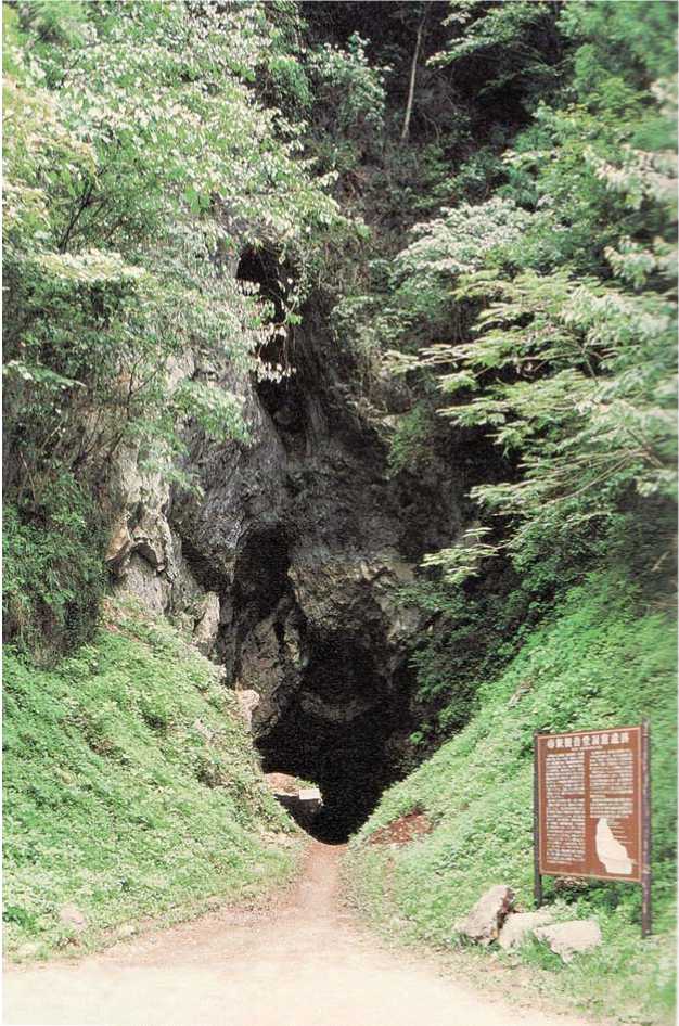
Fig. 2. Kanondo Cave. Modern view. Photo by the authors.
bones of Pleistocene animals were found between layers 5 and 6. The remains of burnt soil were recorded in layers 2, 3 in the far part of the cave. Many fireplaces have been found, especially in sector D (dating to Late Jomon). According to the researchers, this was the main living space. Pottery and stone tools are accumulated in the western part of the cave. The bones of small animals (snakes, mice, bats) show no signs of heating. It is known that the meat of large animals, such as deer and wild boar, was used as food (Shiomi, 1999: 124).
Kobodaki Cave, like Kanondo Cave, is one of the main archaeological sites at the bottom of the Taishaku Gorge. It is located at the base of a limestone cliff; owing to the similarity of the latter with a waterfall, the cave was named “Kobo Falls”. Excavations of the site have been carried out since 1985 to the present. When exploring the cave, 16 layers were identified. According to the excavations, the cave was used mainly during the Jomon Period, as well as during the Kofun Period and in the Middle Ages. Materials from layer 4 date to the Middle Jomon; the lower half of the cultural layer of the Jomon Period is rich in pottery. The finds allow us to trace the formation of the archaeological site back to the beginning of the Jomon Period or the Paleolithic era. The inner space of the cave was apparently vast.
Yosekura rock shelter is located on the left bank of the Taishaku River, in the eastern part of Taishaku district. Its height is 20 m, width 14 m, depth 15 m, entrance width
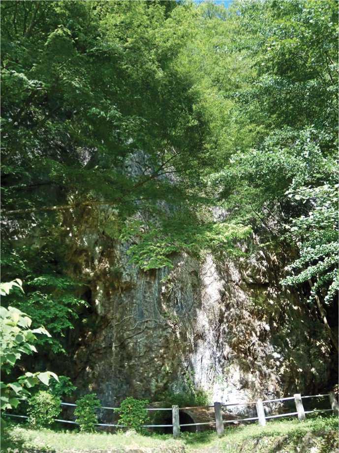
Fig. 3. Yosekura rock shelter. Modern view. Photo by the authors.
50 m; the entrance is oriented to the SW (Fig. 3). The age of the finds ranges from the Initial Jomon to the Middle Ages. Among the finds, artifacts of the Jomon Period predominate. The Yosekura rock shelter is a site with clear stratigraphy. Its layers yielded numerous ceramic finds, serving as a reference point for the identification of ceramics of the Jomon Period in the Chugoku and Shikoku regions. Rich material was also found in common graves of the Late and Final Jomon.
Conclusions
On the Japanese islands, approximately 700 cave archaeological sites were discovered. Among them, there are 50 sites with finds from the Incipient and Initial Jomon. Most of the materials from the caves date back to 9000 BC, the Initial Jomon. This can be explained, first, by the population growth, the transition to a sedentary lifestyle; second, by the emergence of fishing and hunting areas, the development of territories suitable for collecting plant food, the creation of open areas for industrial and economic purposes, with the result that caves began to be used for burials. Thus, the materials of the studied cave sites testify to a transition to new forms of adaptation and a change in foraging strategies in the Initial Jomon.
The huge number of unexplored caves of the Japanese archipelago is a potential source of new information for studying the issues of inhabiting and use of caves. The group of sites in the Taishaku Gorge continues to be studied, in particular, using the latest technologies, for more than 50 years. The materials of the described sites allow us to trace in detail the stages of development of the Chugoku region territory since the Paleolithic, and to shed light on the formation and development of the Jomon culture.
Acknowledgements
This study was supported by the Russian Science Foundation (Project No. 19-18-00003).
