The degree of archaeological certainty of the sites covered by geophysical studies was rather high. Systematic collection of items and ceramic materials, drilling of magnetic anomalies*, pitting, and excavations of certain cultural layer areas were carried out at the settlements. Geophysical methods used made it possible to specify the site outlines, to identify archaeological objects, to assess their shapes and the structural features of the cultural layer, and to reconstruct the spatial characteristics of the identified objects.
*A boring-bit 3 cm in diameter was employed for probing, which was compatible with natural disturbances of the cultural layer (tree roots, rodent holes, etc.). During recent years, drilling has frequently been used for archaeological field studies (Zakharov, Zozulya, 2015: 158; Ibsen, 2013: 234).
Delineation of the site borders and search for archaeological objects
Magnetic prospecting was used to assess the sizes of settlements, and the main trends in their layout. Comparing the results obtained at 15 Suzdal Opolye settlements enabled identification of five main types of anomalies: linear anomalies with high intensity of magnetization; local contrast anomalies with high gradient of attenuation; highly-dispersed zones of magnetic field; dipolar anomalies; and large zones with a relatively high value of magnetic field, without the pronounced adjacent “negative” anomaly.
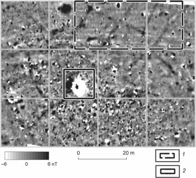
Linear anomalies with high magnetization intensity, which are observed actually throughout the entire area of studies, reflect cryogenic polygonal topography formed as a result of frost fracturing in the uppermost portions of earth’s crust. In particular, such structures are distinctly visible on the map of the Vishenki-3 settlement (Fig. 1). Local contrast anomalies with high gradient of attenuation can be caused by present-day metal objects: for example, by a metal pipe fragment marking the corner of the excavation area at this site (Fig. 1). These anomalies are considered as confounders in interpretation of the magnetic field distribution “map”.
Highly-dispersed zones of magnetic field (areas with randomly scattered local anomalies of relatively small amplitude) can correspond to the areas of cultural layer rich in pottery fragments, slags, oven stones, and other inclusions with an increased magnetization. A number of magnetic anomalies were explored in such zones at the Bolshoye Davydovskoye-2 settlement*. In ten such
20 m
Fig. 1. Fragment of magnetogram from the Vishenki-3 settlement.
1 – area of contrasting evidence of cryogenic polygonal topography; 2 – anomaly caused by a present-day iron object.
zones, cultural strata with a thickness from 0.75 to 1.90 m have been recorded; fragments of burnt clay, sometimes interlayers of weakly fired clay, considerable inclusions of coal or, more rarely, ashes, and small oven stones are clearly visible. Judging by the character of the filling, the studied objects can be considered underground parts of utility, or dwelling, structures. In two instances, natural topographic lows filled with cultural layer are recorded in magnetograms. The filling of five anomalies does not show any considerable thickness (no more than 0.5 m with the average layer thickness of 0.30–0.45 m at the contrast points); however, it is characterized by high humification of the layer and high contents of coals and burnt clay, which allows the preliminary interpretation of identified objects as traces of aboveground or slightly underground utility structures. In general, the configuration of the highly-dispersed zone of magnetic field provides a provisional estimate of the settlement’s outlines (Frantov, Pinkevich, 1966: 140). This is indirectly proved by a stable correlation between the borders of the accumulations of magnetic anomalies and the distribution of surface archaeological finds (Fedorina, 2012).
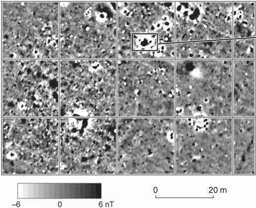
The most impressive are anomalies of dipolar type (a “positive” anomaly combined with a less intense “negative” one), which are usually caused by thermoremanent magnetization objects such as remains of hearths, forges, furnaces or accumulations of slags. They have been studied at two settlements, Ves-5 (Fig. 2) and Shekshovo-2. In the area of anomaly A34 (hereinafter, the designations of anomalies correspond to the materials of studies conducted at Suzdal Opolye settlements) at Ves-5 (Fig. 2, a, b), a suboval subsoil pit of 1.7 × 2.2 m in size was found, covered by a plowed cultural layer 0.2–0.3 m thick (Fig. 2, c). The thickness of cultural deposits in the pit reached 1.1–1.2 m (Fedorina, Krasnikova, Mesnyankina, 2008). Large pieces of smelter slag, forming several separated interlayers, were the most prominent characteristic of the pit-filling. Therewith, small fragments of slag were contained in all observed strata. The weight of slag recovered from the pit totaled 236 kg. In addition, several carbonaceous interlayers were observed in the filling. Thus, the identified object represents an accumulation of waste from medieval metallurgical production. On the basis of the associated ceramic materials, the time when these cultural deposits were formed may be attributed to the 12th–13th centuries. Also, two other magnetic anomalies showing similar characteristics were studied: anomaly А35 at Ves-5 (Ibid.) and anomaly А1 at Shekshovo-2 (see below).
а
с
Fig. 2. Results of studies at the Ves-5 settlement.
a – fragment of production zone magnetogram, an area of anomaly A34 (the border is shown in red); b – anomaly A34, location of t he excavation area (the border is shown in blue); c – photo-recording of the pit’s northern outline (view from the south).
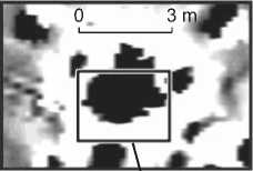
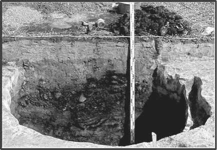
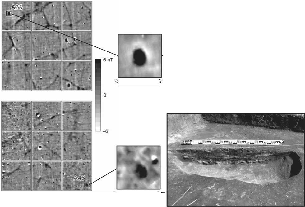
The last type of anomaly revealed by magnetic survey at Suzdal Opolye settlements embraces large zones showing relatively high values of magnetic field without pronounced adjacent “negative” anomaly. These can be caused by various subsoil pits filled with humus layer. As an example, let us consider two objects on the periphery of the Bolshoye Davydovskoye-2 settlement. Anomalies have similar magnetization parameters, as well as shape and linear dimensions (Fig. 3, a). Similar stratigraphy is observed in the probe trenches: a cultural layer 0.3– 0.4 m thick is fully mixed by recent plowing; below is subsoil represented by packed yellow loam. Objects corresponding in size and shape to magnetic anomalies are buried in the subsoil. Anomaly A35 (Fig. 3, b) is caused by a suboval pit 2.0 × 0.9 to 1.2 m in size, filled with darkcolored humus loam with a considerable coal admixture. In the lower portion of the filling, ash interlayers, blocks of calcined packed red loam, and large fragments of wheel-thrown ware were found. The maximum depth of the pit is 0.37 m. Taking into account the peculiarities of the filling, this object may be interpreted as the remains of an open summer oven or a hearth. The pit related to anomaly A46 (Fig. 3, c) has a rounded shape (1.5 m in diameter, maximum depth of 0.28 m). Its filling shows an increased humification and a high contents of ashes, coal, and burnt clay fragments. The identified object is slightly buried in the subsoil.
Thus, the use of magnetic prospecting at settlements of Suzdal Opolye allows us to predict the outlines of the cultural layer’s distribution, and to locate the densely inhabited areas, remains of production complexes, and sometimes pits. Restrictions are determined by external circumstances, since stable selection of grounds for settlements, along with high variability of their internal layout structure, causes “overlapping” of objects with similar magnetic characteristics. Combined with a high degree of destruction of cultural layers by centuries-old plowing, this results in noticeable blurring of magnetic-field distribution. In Suzdal Opolye, magnetic prospecting allows assessment of the structure and layout of settlements in the broadest strokes, and cannot provide the required level of detail. Its main advantages are the speed of the studies, and the possibility of identifying areas for further geophysical measurements.
Assessing the spatial characteristics of sites and the features of layer structure
Electrical prospecting (areal electrical profiling with sequential change in the probing depth) was applied to reconstruct the layout of separate areas of the settlements. Unlike magnetic prospecting, this approach allows assessing the relative distribution of archaeological objects within a cultural layer. Specifically, at Shekshovo-2, electrical profiling was conducted in the central part of the site, in a zone with
b
та
6 nT
№46
6 m
—— -
20 m
6 m
а
Fig. 3. Results of studies at the Bolshoye Davydovskoye-2 settlement.
a – fragments of magnetogram on settlement’s periphery (borders of anomaly areas are shown in red); b – anomaly A35 and photo-recording of the object (view from the north-east); c – anomaly A46 and photo-recording of the object (view from the south-west).
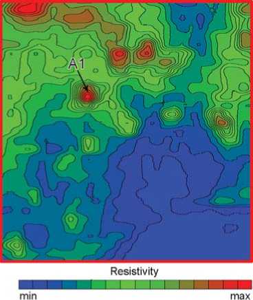
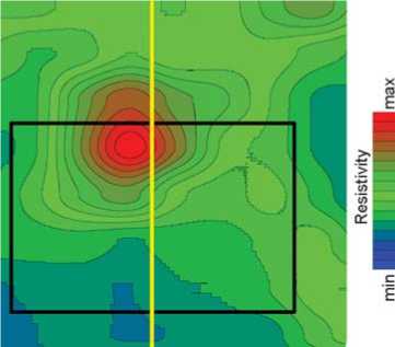
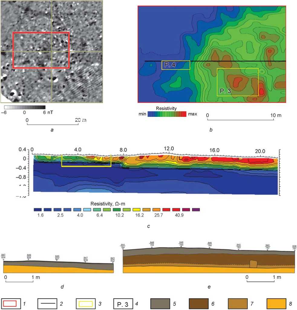
high density of local magnetic anomalies. A dipolar anomaly was recorded here, which was interpreted as the remains of an object related to metallurgical production (Fig. 4, a). Electrical profiling of the area has revealed a series of local high-resistance objects (Fig. 4, b). In general, similarity is observed in both geophysical maps, which demonstrate reduction in both the thickness and the richness of cultural strata in the southeastern corner of the survey-loop of electrical profiling. However, the presence of magnetic anomaly A1 prevents only the reconstruction of the area’s development structure that is based on the magnetic prospecting data; whereas the electrical profiling results have revealed local objects in the immediate vicinity of this anomaly.
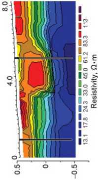
A rounded pit 3.0 × 2.1 m in size corresponds to anomaly A1, which is in agreement with the geometrical parameters of anomalous resistivity. Even in the upper layers of measurements, this object was unambiguously identified as a local region of high resistance with clearly defined borders (Fig. 5, a). This corresponds to archaeological data: the pit is clearly identified at a depth of 0.35 m from the present-day surface. Adjacent pits observable starting from the level of subsoil were identified against the background of the surrounding low-resistance region only in the deeper measurement layers (cf. Fig. 5, a, c).
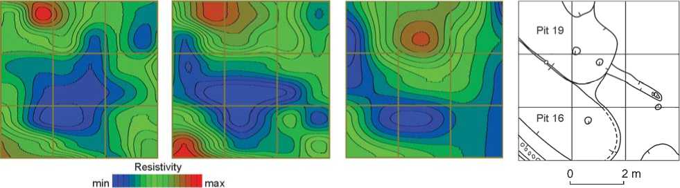
Similar changes in the borders and structure of anomalies within the cultural layer have been detected when studying the subsoil pits in the central part of Kistysh-3 settlement. The excavations have demonstrated that pits 16 and 19, determining one of the anomalies, represent the remains of cellars, separated by a subsoil partition, which sequentially changed one another (Krasnikova, Fedorina, 2008). They are recorded as a local high-resistance region of suboval shape. In this case, it is characteristic that the anomaly reveals itself ambiguously in the upper layers (Fig. 6, a); however, as the depth of probing increases, its borders are clearly defined against the background of the surrounding low-resistance region (Fig. 6, b, c). Such dynamics suggests that the archaeological object is a set of subsoil pits with strongly humic filling. The excavations have shown a

20 m
а
6 nT
0 2 m
b
Fig. 4. Relation between magnetic prospecting and electrical prospecting at the Shekshovo-2 settlement. a – fragment of magnetogram, border of the electrical profiling area (shown in red); b – results of electrical profiling.
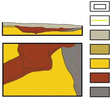
Fig. 5. Results of studies at the Shekshovo-2 settlement.
a – results of electrical profiling in the area of anomaly A1; b – geoelectrical section in this area; c – generalized drawing of the northern outline of the excavation area and the cleaning plan.
1 – border of the excavation area; 2 – location of the geoelectrical profile; 3 – plowing horizon; 4 – pre-subsoil; 5 – subsoil; 6 – cultural layer with inclusions of burnt clay, coals, and slags; 7 – cultural layer with inclusions of ceramics, animal bones, and oven stones.
good agreement between configuration of pit and shape of anomaly (Fig. 6, d). It should be noted that only the deeper northern pit 19 has been unambiguously revealed by electrical profiling results. This is explained by the low contrast of electrical properties in the southern pit 16 with weakly humic filling with a relatively small depth (no more than 0.3 m from the subsoil surface) and a commensurable thickness of the overlying cultural layer
(0.4 m). Consequently, subsoil pits filled with cultural deposits are identified as local high-resistance objects with clearly defined borders in the lower measurement “layers”. At the same time, deeper pits with filling of greater contrast can be clearly located.
In order to assess the shapes of layout objects, an effort was made to use ground-penetrating radar. This method is effective at Suzdal Opolye settlements when
b
d
а
с
Fig. 6. Results of electrical profiling and excavations at the Kistysh-3 settlement. a – depth of probing 0.7 m; b – 1.0 m; c – 1.5 m; d – generalized drawing of the subsoil cleaning plan.
studying relatively small quantities of archaeological objects, primarily remains of deep (up to 2 m) cellars of buildings and separate vaults characterized by large plan dimensions and depth (Shpolyansky, 2008). Specifically, radargrams made during the survey of Kibol-5 have identified (with a reasonable degree of accuracy) pits representing deep cellars of medieval buildings (3.6 × 4.5 × 1.9 m and 3.5 × 4.0 × 1.8 m in size). Nevertheless, it has been impossible to identify a number of objects similar in their archaeological characteristics and size.
Assessing the thicknesses of cultural strata was another important task. The density of local magnetic anomalies in the eastern part of Shekshovo-2 (Fig. 7, a) is appreciably smaller than in the western one. This territory was probably the settlement’s periphery. Electrical prospecting has revealed an increased-resistance zone in the eastern part of the geophysical table. Its border is most distinctly observed in the lower measurement “layers” (Fig. 7, b). This suggests that the cultural layer’s thickness is smaller in the western part. The results of excavations confirm this interpretation of the geophysical data: the thickness of the humus layer in excavation area 4 smoothly increases from west to east from 0.10 to 0.25 m (Fig. 7, b, d), and reaches 0.5–0.6 m in excavation area 3 (Fig. 7, b, e).
In general, electrical profiling ensures more detailed reconstruction of the cultural strata’s structure than magnetic prospecting does. When studying Suzdal Opolye settlements, electrical prospecting allows for accurate determination of the borders of areas with great thicknesses of cultural layer. Information about the shapes and structures of anomalies provides the basis for qualitative interpretation of local archaeological objects, and for rough assessment of their geometric parameters and depth of location. Consequently, for detailed reconstruction of the spatial distribution of objects in the cultural layer, it is necessary to supplement data from planigraphic survey (magnetic prospecting, electrical profiling) with geophysical information about the site’s stratigraphy.
Assessing spatial characteristics of the identified objects
Normally, such studies are conducted only in the key areas, identified on the basis of preliminary measurements, rather than throughout the entire area of interest. This line of research was implemented at Suzdal Opolye settlements by means of electrical tomography, which resulted in a geoelectrical section, i.e. a map showing the possible distribution of resistivity in a vertical plane along the selected profile.
At Shekshovo-2, electrical tomography was applied in order to refine interpretation of data obtained by preliminary geophysical survey. Specifically, additional studies of the local resistivity anomaly, revealed in the western part of settlement, allowed not only confirmation of the prediction, but also determination of the geometric parameters of the pit before the excavations (see Fig. 5, b). The geoelectrical section in the eastern part of this settlement clearly indicates changes in the thickness of the cultural layer (see Fig. 7, c), which is in good agreement with the data from electrical profiling and the results of excavations.
Conclusions
Study of the Suzdal Opolye settlements demonstrates the necessity for comprehensive use of geophysical methods to record various physical parameters of the near-surface soil layer. Consistent application of magnetic prospecting, electrical profiling, and electrical tomography, and also comparison of geophysical findings with those of drilling,
20 m
Fig. 7. Results of studies at the Shekshovo-2 settlement.
a – fragment of magnetogram on settlement’s periphery; b – results of electrical profiling; c – geoelectrical section; d – generalized drawing of the northern outline of excavation area 4; e – generalized drawing of the northern outline of the excavation area 3.
1 – border of the survey loop of electrical profiling; 2 – location of the geoelectrical profile; 3 – borders of excavation areas; 4 – numbers of excavation areas; 5 – plowed land; 6 – undisturbed cultural layer; 7 – zone of contact between cultural layer and subsoil; 8 – subsoil.
-1.2:
-1 6J
pilot excavations, and tendencies in the distribution of surface finds, allow more accurate interpretation of anomalies and assessment of the distinguishing features of changes in the cultural layer. A combination of conventional techniques of archaeological exploration and field recording of sites with geophysical surveys of medieval settlements makes it possible to outline the borders of settlements; to reveal production zones, primarily those relating to iron smelting; and to localize densely inhabited areas in the territory of sites.

