Contribution of V.A. Rusanov to the Study of Geology and Geography of the Novaya Zemlya Archipelago (On the 150th Anniversary of His Birth)
")
Author: Astakhova I.S.
Journal: Arctic and North @arctic-and-north
Section: Reviews and reports
Article in issue: 62, 2026.
Free access
This paper describes V.A. Rusanov’s expeditions to Novaya Zemlya in 1907–1912. The objectives of the expeditions included studying the coastline, the Northern Sea Route, searching for minerals, and exploring the possibility of organizing fishing. V.A. Rusanov travelled on foot along the shores of Matochkin Shar, Mashigin Bay, and Southern and Northern Sulmenovaya Bay. For the first time, a walking route was completed along Krestovaya Bay in the northern part of Novaya Zemlya. The scientist described the rocks of the Silurian, Devonian, Permian, Carboniferous, and Jurassic periods with paleontological justification. As a result of his research, V.A. Rusanov suggested that in the Silurian period, there was a deep-water sea in the place of Novaya Zemlya. The similarity between the Devonian fauna of Novaya Zemlya and the fauna of Timan allowed him to establish a close connection between the North and European seas. According to V.A. Rusanov, mountain formation occurred at the end of the Palaeozoic era. While studying cephalopods, V.A. Rusanov discovered a new species, Karoceras. He discovered fossil ice in Krestovaya Bay, in the Eastern Valley at Cape Krestovoy. This led to the conclusion that there had been several stages of glaciation. As a result of the expeditions, the main minerals (peat, coal, pyrite, copper ore, galena, ochre) were discovered. The geographical outcome of V.A. Rusanov’s expeditions was the naming of 32 objects.
History, expeditions, Novaya Zemlya, Rusanov, paleontology, minerals
Short address: https://sciup.org/148333293
IDR: 148333293 | UDC: [55:913.1](09)(470.117)(045) | DOI: 10.37482/issn2221-2698.2026.62.251
Text of the scientific article Contribution of V.A. Rusanov to the Study of Geology and Geography of the Novaya Zemlya Archipelago (On the 150th Anniversary of His Birth)
DOI:
The lack of knowledge about the Arctic territories has been a constant subject of interest for travelers, scientists, entrepreneurs and government agencies. Research on the northern islands, particularly Novaya Zemlya, in the late 19th and early 20th centuries was focused on finding the Northern Sea Route, attempts to reach the North Pole, and strengthening the political significance of the North as an important strategic and economic region. However, the harsh northern conditions, inaccessibility, and lack of reliable cartographic materials complicated and increased the cost of organizing systematic research for a long time [1, Filippova T.P.].
The state began actively colonizing Novaya Zemlya in 1881, when a special decree was issued on the settlement of the island in order to prevent the loss of control over the archipelago. Regular shipping was organized and settlements were built. These measures led to the profitability of Novaya Zemlya’s industries [2, Belyaev D.P.].
∗ © Astakhova I.S., 2026
This work is licensed under a CC BY-SA License
Extensive scientific research work on describing and mapping the coastline of Novaya Zemlya, searching for minerals, and studying the flora and fauna was carried out by the expeditions of F. Rozmyslov (1768–1769), V. Ludlov (1807), A.P. Lazarev (1819), F.P. Litke (1821–1824), P.K. Pakh-tusov (1832–1835), and F.N. Chernyshev (1895). V.A. Rusanov can be considered one of those people who actively promoted the development of the Northern Sea Route and conducted detailed research on Novaya Zemlya.
Brief biography and first acquaintance with the Pechora region
Vladimir Alexandrovich Rusanov was born on November 3, 1875, in the city of Orel into a merchant family. In 1897–1898, he was an extra-curricular student at the Faculty of Natural Sciences of Kiev University. For participating in open student “riots”, he was deprived of the right to attend lectures and sent back to his homeland.
In September 1898, Rusanov’s home was searched, he was arrested, and escorted to Moscow, but in November of that year, due to lack of evidence, he was sent back to Orel. In 1899, Rusanov attempted to continue his education and applied to go abroad to study natural sciences at the Collège de France in Paris. His application was denied. In 1900, he was arrested again on charges of revolutionary propaganda, but was released due to lack of evidence.
In May 1901, V.A. Rusanov was exiled to the Vologda province under police supervision for two years. In Ust-Sysolsk, he managed to find a job as a statistician in the district zemstvo administration. Interestingly, statisticians, as hired specialists, had the following characteristic features: a revolutionary past, which made them “politically unreliable” for the government and the provincial administration; a high level of education; a relatively young age; a diverse social composition [3, Levin S.V.]. V.A. Rusanov met all these requirements. In the summer, he had to go on statistical surveys that covered the vast territory of the Ust-Sysolsk district. In July 1902, V.A. Rusanov and A.A. Bogdanov (a doctor by education, exiled to the Vologda province and working as a topographer) set off on their first expedition. From the village of Pomozdino in the Vychegda region, the expedition first traveled north by boat along the Vychegda River, then continued along the Izhma River to the border with Arkhangelsk province and further along the Sedyu River to its upper reaches. From the upper reaches of the Sedyu River, the explorers had to make their way through swampy and wooded areas. The final destination of the expedition remains unclear, but the return route followed the Vol River [4, Rusanov V.A., p. 360]. In the river outcrops, Rusanov discovered Spirifer mollusks of the genus Stola Rhynchonella , belonging to the Middle Devonian period.
In the spring of 1903, Rusanov conducted research from the village of Troitsko-Pechorskoe along the Pechora River to its mouth. A detailed report on this journey, presented to the Vologda Zemstvo Assembly, was published as a separate brochure in Vologda in 1904. It examined the problem of connecting the Pechora and Kama rivers. The scientist proposed a waterway along the Berezovka and Bezvolosnaya rivers [4].
The results of each expedition to the Pechora region were recorded in a small number of works by V.A. Rusanov, which provide information about the life, economy, customs and folklore of the Zyryans. Rusanov himself considered his first expedition to be successful and described the results as follows: “In 1902, a partial statistical and economic survey of the Ust-Sysolskiy district was conducted for the first time; the statistical material collected concerned the upper reaches of the Vychegda (a tributary of the Northern Dvina) and Izhma (a tributary of the Pechora) rivers. The statistical survey forms did not include questions about artels... I was able to confirm the existence of artels in the main industries; later, I discovered the structure of artels and their great diversity” [4, p. 329]. Already in Paris in 1907, he published this material in his monograph “Zyryans”, where he noted the widespread development of artels, collective forms of labor among the population. In the preface to the publication “Non-Agricultural Industries of the Vologda Province”, published in 1903 by the Industrial Bureau of the Vologda Provincial Zemstvo under the editorship of A.I. Maslennikov, it is stated that the “Essay on the Industries of the Ust-Sysolskiy District” was compiled primarily from the notes of V.A. Rusanov, who collected a large amount of material during his numerous trips to the Pechora region [5]. Based on the results of his expeditions, the scientist describes iron pyrites in the upper reaches of the Izhma River, bizarre cliffs with fibrous white asbestos, used for the manufacture of fireproof items, and points to rocks with a pungent petroleum odor on the Ukhta River. He noted only two locations where mineral resources were being exploited: one of these mining sites is located in the south of the Ust-Sysolskiy district, where the Kazhimskiy iron foundries and ironworks are located, and the second one is associated with the extraction of grinding stone on the Voya and Soplyas mountains. As V.A. Rusanov pointed out, “the exploration and development of the undoubtedly diverse and large resources scattered along the Northern Urals is a rewarding task for the near future” [4, p. 350].
After two years in the Pechora region, V.A. Rusanov applied to go abroad and in the autumn of 1903, together with his wife, he left for Paris, where he enrolled at the Sorbonne’s Faculty of Natural Sciences. During his first year, Rusanov studied only botany and mineralogy, which he successfully passed by the end of 1905. After passing his exams, V.A. Rusanov went to central France to do practical work under the guidance of the famous mineralogist Professor A.F. Lacroix to study the extinct volcanoes located there. In the summer of 1907, V.A. Rusanov successfully passed the exam in his main subject, geology, and received a diploma for completing the full course of study in the Faculty of Natural Sciences. As V.A. Rusanov wrote in a letter to his stepfather in 1907: “...for the vast majority of French students, this is the only goal they pursue, but for me, it will be, at best, only half of the preparatory scientific path that I have decided to take” [4, p. 382].
Expeditions to the Novaya Zemlya archipelago
After receiving his degree in natural sciences in 1907, V.A. Rusanov went on a short geological expedition to Novaya Zemlya. His main goal was not only to collect geological material for his doctoral dissertation, but also to study the conditions for navigation. The most suitable area was the coast of Matochkin Shar, a strait that allowed access to the Kara Sea. In early July, he arrived in Arkhangelsk. On the steamship “Queen Olga”, V.A. Rusanov, together with L.A. Molchanov, a zoology student from Kharkov University, reached the coast of Matochkin Shar. Yefim Khatanzey, a Nenets, served as the expedition’s guide. They reached the Gusinaya River by boat. Rusanov examined outcrops and collected rock samples that formed the shores of Matochkin Shar (Fig. 1).
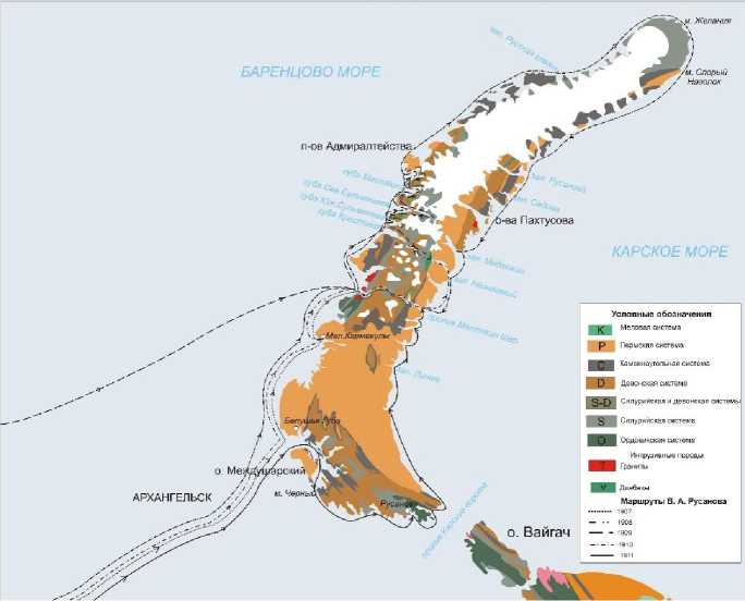
Fig. 1. Map of V.A. Rusanov’s routes to Novaya Zemlya.
He studied the glaciers with particular attention. Difficult weather conditions hampered the expedition’s progress, but the researchers travelled by karbas along the Matochkin Shar Strait to its easternmost point, Cape Vykhodnoy. During the expedition, Rusanov discovered small crystals of copper pyrite in a quartz-feldspar vein on the shore of the narrowest part of the strait and red ochre deposits at Cape Vykhodnoy. On 26 August, the expedition returned to camp, where they had to stay until the arrival of the steamship “Queen Olga”.
This expedition was of great importance for further research into the geology of Novaya Zemlya. The detailed study and description of Matochkin Shar deposits led to Rusanov’s appointment as a geologist on a polar expedition to Novaya Zemlya organized by the French Academy of Sciences in 1908 (Fig. 2). The expedition was planned to be carried out on the vessel “Jacques Cartier”, but due to weather conditions, part of the expedition continued its route to the Nenets settlement of Matochkin Shar on the steamship “Queen Olga”. Two karbases were used to reach the Kara Sea, then, heading north, enter the nearest bay. From there, they crossed the northern island on dog sleds and reached the Barents Sea. The beginning of the expedition’s route partially retraced the route along Matochkin Shar already completed in 1907. Rusanov, along with his graduate student Neve, climbed to the top of Mount Vilcheka, where he discovered pyrite crystals in shales. By the end of August, the expedition reached the most remote point of Neznaemy Bay, which had been inaccessible the previous year due to heavy ice. Next, they had to hike through Krestovaya Valley, during which Rusanov discovered an unknown genus of cephalopods in Silurian period sediments. For several days, the expedition struggled to reach the western coast of Novaya Zemlya, and only Rusanov reached the coast of Krestovaya Bay. This was the first trek across the northern part of Novaya Zemlya. The expedition then returned to camp on the shore of Neznaemy Bay. The expedition along Matochkin Shar continued for two weeks, until 27 September, when the steamship “Queen Olga” arrived and took the travelers to Belushya Bay. There, they boarded the ship “Jacques Cartier”, which took them back to Arkhangelsk. Based on the results of the expedition, Rusanov compiled a report, and Captain Bernard included materials in a separate chapter entitled “Geology, Fauna and Flora of Novaya Zemlya” written by V.A. Rusanov in his book “Dans l'ocean glacial et en Nouvelle Zemble” [6, Barr W.].
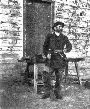
Fig. 2. Rusanov V.A., 1908 [5].
In 1909, at the invitation of Arkhangelsk Governor I.V. Sosnovskiy, V.A. Rusanov took part as a geologist in the Novaya Zemlya expedition of the Main Directorate of Agriculture and Land Management [4]. The expedition was to survey Krestovaya Bay on the northern island of Novaya Zemlya and the coastline from this bay to the Admiralty Peninsula, to determine the possibility of organizing fishing here, and to establish how suitable Krestovaya Bay was for establishing a Russian settlement there. The expedition arrived at Krestovaya Bay on the steamship “Queen Olga”, where they established their main base. During their stay in Krestovaya Bay, Rusanov studied the coastal geology. He explored the outcrops of rocks from Krestovaya Bay to the Admiralty Peninsula on foot. He surveyed the western coast of Novaya Zemlya’s northern island, including Kresto-vaya, Sulmeneva, and Mashigina Bays, as well as Sadovskiy, Sosnovskiy, and other gulfs. He discovered Carboniferous limestones with Prodoctides , noted gray marbles, and on one cape, in Krestovaya Bay, numerous, fairly large pieces of coal (lignite) were found scattered across the surface in Quaternary deposits. In Sulmeneva Bay, he assembled a rich collection of Devonian fossils and traced outcrops of diabase and metamorphosed schists. Based on the results of the expedition in 1909, V. V. Rusanov gave a lecture at the Arkhangelsk Society for the Study of the Russian
North on the topic of “Fossil glaciers and coal on Novaya Zemlya in relation to the geological structure of the island”. He published “Review of the activities of the Novaya Zemlya expedition of 1909” and the articles: “Novaya Zemlya Coal and Centuries of Land and Sea Movements”, “Description of the Coasts and Interior of Novaya Zemlya from the Admiralty Peninsula to Krestovaya Bay and from the latter to Neznaemy Bay”, “On Mineral Resources on Novaya Zemlya”, and others [7; 8; 9]. For the results of his work in 1909, a year later, V.A. Rusanov was awarded the Order of St. Vladimir, 4th degree.
In previous expeditions to Novaya Zemlya, V.A. Rusanov had proven himself to be a highly qualified specialist and a good organizer. In 1910, Governor I.V. Sosnovskiy, organizing an expedition to Novaya Zemlya, appointed V.A. Rusanov as its head. The expedition included mining engineer M.M. Kruglovskiy, zoologist S.S. Ivanov, anatomist S.S. Chetyrkin, navigator V.E. Remizov, guide Ilya Vylka, and others. The plan was to sail around the entire northern island of Novaya Zemlya on the ship “Dmitriy Solunskiy”, round Cape Zhelaniya from the west, and then sail along the eastern coast of Novaya Zemlya to Matochkin Shar via the Kara Sea. At the end of the expedition, I.V. Sosnovsky noted: “The most important practical results achieved by the expedition were the discovery of four more Norwegian fishing grounds in the north of Novaya Zemlya, in addition to the one discovered in 1909 in Krestovaya Bay; the observation of the distribution of ice in relation to the nature of local winds and the direction of sea currents, which was highly important for resolving the issue of the Northern Sea Route to Siberia; the survey of the northwestern coast of Novaya Zemlya in terms of colonization and commercial exploitation; the compilation of highly important scientific collections on geology, paleontology, botany, entomology, zoology, etc.” 1 At a meeting of the Geographical Section of the Society of Lovers of Natural Science, Anthropology, and Ethnography at the Polytechnic Museum, Rusanov gave two reports on the expedition around the northern island of Novaya Zemlya, in which he described in detail the observations of the No-vaya Zemlya expedition. At the same time, his detailed description of the 1910 expedition, “On the Dmitriy Solunskiy around Novaya Zemlya”, a detailed article, “On the Topography of Novaya Zemlya”, a brief summary, “On the Hydrological Work of the Novaya Zemlya Expedition of 1910”, and others were published [11].
In 1911, the Main Directorate of Agriculture and Land Management organized a third expedition to Novaya Zemlya. The main objective was to survey the southern coast of Novaya Zemlya, in particular Petukhovskiy Shar and Reineke Bay. As it moved along the southern coast of No-vaya Zemlya, the expedition conducted meteorological and hydrographic research. As a result of the voyages of 1910–1911, V.A. Rusanov published an article entitled “The Economic Significance of the Northern Sea Route to Siberia”, in which he argued that “no other route can be more profitable than the Northern Sea Route” and that “no other route can be faster than the Northern Sea Route” [11, p. 190].
In 1912, V.A. Rusanov planned to continue his exploration of Novaya Zemlya in the Sakhan-ikha Bay area, but circumstances prevented this. In the spring of 1912, the Russian government offered V.A. Rusanov the opportunity to lead an expedition to Spitsbergen. According to Samoylovich, a member of the Spitsbergen expedition, Rusanov did not limit himself to exploring the island alone; he wanted to conduct hydrological and hydrographic work between Spitsbergen and No-vaya Zemlya, visiting Uedineniya Island, and conducting a geological survey [12]. The further route of the “Hercules”, as is commonly believed, lay to the northern tip of the island, and in early September, the “Hercules” was supposed to enter the waters of the Kara Sea, but the ship disappeared. There are many theories in the literature regarding the expedition’s route and location of demise. It is believed that the easternmost point of the route was on Veizelya Island (now Hercules Island), where a pillar with the inscription “HERCULES. 1913” was discovered [13]. The Arkhangelsk Museum of Local History (Arkhangelsk) and the Russian State Arctic and Antarctic Museum (St. Petersburg) house some of the equipment found during the searches of V.A. Rusanov’s 1912– 1913 expedition.
The most important geological and geographical results of V.A. Rusanov’s expeditions
Many researchers have studied the history of the discovery and expeditionary exploration of the shores of Novaya Zemlya. The issue of cartography and toponymy of the archipelago is particularly acute. It has been established that the first map depicting the southern tip of Novaya Zemlya was made in 1562 — “New Improved (Map) of Russia, Muscovy and Tartary” by Antonio Jenkinsono Anglo [14]. There are many inaccuracies in the cartography of Novaya Zemlya in the 17th and early 20th centuries, ranging from the geographical location of the archipelago to the identification of coastal points on the western and eastern coasts. There were many maps published in different languages, by different people and based on different primary sources. A particular difference is related to toponymy. Each expedition to Novaya Zemlya, especially foreign expeditions, sought to give their own names, disregarding existing ones. As a result, some points had a series of names. For example, the ridge located in Mashigina Bay was named “Bolshaya Chyornaya” (Big Black) by the Weber expedition in 1901; Rusanov V.A. named it “Chyornaya Mountain” (Black Mountain), and O. Goltedal, a member of the Norwegian expedition, in 1921 — “Nansen Mountain”. Only after the creation of the nomenclature commission under the Polar Commission of the Academy of Sciences at the end of 1933, the names of geographical objects on Novaya Zemlya were agreed upon [15]. During his expeditions, V.A. Rusanov assigned 32 new names to geographical objects (Table 1). Some of them were renamed. Geologists working in the Novaya Zemlya region deeply honored the memory of V.A. Rusanov. Thus, one of the main tasks included in the work plan of the Novaya Zemlya expedition of the Academy of Sciences in 1925 was to compile a geological profile of the valley from Neznaemy Bay to Krestovaya Bay, which V.A. Rusanov named in honor of the physician and participant in the 1908 expedition, Candiotti. The participants of the 1925 expedition of the Academy of Sciences renamed it in honor of V.A. Rusanov [16].
Table 1
|
Object |
Name |
Georeferencing |
Year |
|
Goltsovaya Bay |
Neznaemy Bay |
1908 |
|
|
Makarov-Zherve Glacier |
Stepan Osipovich Makarov (1848–1904), Russian naval commander, admiral |
Neznaemy Bay |
1908 |
|
Cape Ptichiy |
Western coast of Novaya Zemlya |
1908 |
|
|
Candiotti Valley, (since 1925, Rusanov Valley) |
Candiotti, doctor of V.A. Rusanov’s expedition. In 1925, the Novaya Zemlya Expedition of the Academy of Sciences renamed it in honor of V.A. Rusanov (1875–1913) |
Neznaemy Bay |
1908 |
|
Lacroix Glacier |
Alfred François Lacroix (1863-1948), French mineralogist and petrographer, professor at the Sorbonne University |
Mashigina Bay |
1909 |
|
Lorentz Island |
Karl Alexandrovich Lorenz (1874–1938), botanist, expedition participant |
Northern Sulmeneva Bay |
1909 |
|
Bulya Glacier |
Pierre Marcelin Boulle (1861–1942), a renowned French paleontologist and geologist, professor at the Museum of Natural History in Paris |
Mashigina Bay |
1909 |
|
Island, Cape Bykov (since 1926, island, Cape Afanasyev) |
Alexander Alekseevich Bykov, expedition member, photographer |
Northern Sulmeneva Bay |
1909 |
|
Galakhova Island |
Pavel Alexandrovich Galakhov, expedition member, junior official on special assignments under the Arkhangelsk Governor I.V. Sosnovskiy |
Mashigina Bay |
1909 |
|
Mountains, Mendeleev Glacier |
Dmitriy Ivanovich Mendeleev (1834–1907), Russian chemist, encyclopedist, teacher and public figure |
Western coast of Novaya Zemlya |
1909 |
|
Sadovskiy Bay |
Boris Ivanovich Sadovskiy, head of the Arkhangelsk provincial chancery under Governor I.V. Sosnovskiy |
Admiralty Peninsula |
1909 |
|
Sosnovskiy Bay |
Ivan Vasilyevich Sosnovskiy (1868 – after 1917), State Councilor, Chamberlain; Arkhangelsk Governor in 1907–1911. |
Admiralty Peninsula |
1909 |
|
Shumniy Glacier |
South Bay |
1909 |
|
|
Bay, glacier, Mount Krivoshein |
Alexander Vasilyevich Krivoshein (1857–1921), Chief Administrator of the Ministry of Land Management and Agriculture, State Secretary |
Western coast of Novaya Zemlya |
1910 |
|
Bay, Vilkitskiy Glacier |
Andrey Ippolitovich Vilkitskiy (1858–1913), Russian hydrographer-geodesist, lieutenant general of the naval navigators’ corps |
Western coast of Novaya Zemlya |
1910 |
|
Vylki Glacier |
Ilya (Tyko) Konstantinovich Vylka (born in 1886), Nenets, expedition participant |
Western coast of Novaya Zemlya |
1910 |
|
Cape, Mount Kruglovskiy |
Mikhail Mikhailovich Kruglovskiy, mining engineer, expedition participant |
Mashigina Bay |
1910 |
|
Cape, Maslennikov Glacier |
Dmitriy Nikolaevich Maslennikov, Arkhangelsk fishing industrialist |
Western coast of Novaya Zemlya |
1910 |
|
Nordenskjöld Glacier |
Adolf Erik Nordenskjöld (1832–1901), Swedish geologist and geographer, Arctic explorer, navigator |
Western coast of Novaya Zemlya |
1910 |
|
Og Bay |
Gustave Emile Auge (1861–1927), French geologist, professor of geology at the Sorbonne |
South of Sedov Bay, in the east of Novaya Zemlya |
1910 |
|
Pakhtusov Island |
Petr Kuzmich Pakhtusov (1800–1835), second lieutenant, Russian navigator, hydrographer |
Tsivolki Bay |
1910 |
|
Pospelov Bay |
Grigory Ivanovich Pospelov (1869–1933), captain of the sail-motor cutter of the expedition “Dmitry Solunskiy” |
South of Cape Zhelaniya |
1910 |
|
Shurin Bay (since 1925, Rusanov Bay) |
Alexander Vladimirovich Rusanov, son of V.A. Rusanov |
Eastern coast of Novaya Zemlya |
1910 |
|
Sedov Bay |
Discovered by V.A. Rusanov. Named in 1925 by R.L. Samoylovich’s expedition in honor of the renowned Arctic explorer Georgiy Yakovlevich Sedov (1877–1914). |
North of Og Bay |
1910 |
|
Bay, Jean Glacier |
Juliette Jean (1886–1913?), fiancée of V.A. Rusanov, geologist, participant of the expedition |
Krivoshein Bay and Arkhangelsk Bay, western coast of Novaya Zemlya |
1911 |
|
Cape of Solunskiy |
In honor of the ship “Dmitry Solunskiy” |
Krivoshein Bay |
1911 |
Over several years of studying Novaya Zemlya, V.A. Rusanov collected extensive palaeontological and lithological material, on the basis of which the first assumptions about the history of the geological development of the territory were made.
V.A. Rusanov published several articles and lectures on various geological issues. Of particular note are his special articles on Quaternary geology. These articles examine issues of glaciation, fossil glaciers, and the sequence of glacial fluctuations. He discovered fossil ice in Krestovaya Bay, in the Eastern Valley at Cape Krestovy. He established the ancient origin of the ice in relation to the overlying layers of clay, sand and pebbles. He discovered shells of lamellibranch molluscs Astarte borealis Chemn., Astarte sulcata da Costa, Astarteelliptica Brawn., Saxicava artica Lin., Mya trucata Lin., and Macoma calcaria Chemn. on the surface. This fact did not allow V.A. Rusanov to definitively state that the deposits were post-Pliocene in age, but further research established the presence of boreal transgression fauna and post-glacial (more arctic) fauna, proving several periods of glaciation [20]. Even today, there are various paleogeographic concepts regarding the scale of Pleistocene glaciations. Some researchers insist on glacial environments during the late Pleistocene-Holocene period and the glacioisostatic nature of the archipelago’s terraces, while others extend the age to the Neogene, and associate their origin with complex transgressive-regressive cycles in the late Cenozoic [21].
In 1908, V.A. Rusanov discovered Upper Silurian deposits in Neznaemy Bay [22]. Research conducted in 1909 on the western shore of the Northern Sulmenevaya Bay significantly expanded the distribution area of Silurian rocks. For a number of forms from Neznaemoy Bay, a new genus, Karoceras , was established, to which he assigned a number of species. In this collection, V.A. Rusanov identified one species as identical to Cyrtoceras laminare Barrande , and in subsequent
Geographical discoveries of V.A. Rusanov 2
REVIEWS AND REPORTS
Irina S. Astakhova. Contribution of V.A. Rusanov to the Study of Geology and Geography … works he refers to it as Karoceras laminare Barrande . In this regard, comparing his discoveries with those of Barrande, the scientist concludes that at the end of the Upper Silurian period there was a close connection between the Arctic Ocean and the sea of Western Europe, but believes that later this connection was limited, since the fauna of “karoceras” is very specific to Novaya Zemlya.
Cephalopod doublets from the collection assembled by Rusanov and housed in the National Museum in Paris were transferred for study to A.F. Foerste and served as material for his work “Cephalopoda from Nesnayemi and Sulmeneva Fjords in Novaya Zemlya”, published in 1925 [23]. Based on the analysis of the cephalopod fauna, the author comes to the conclusion about its Upper Silurian or Lower Devonian age; he considers the latter more likely, citing indications of the predominance of Lower Devonian deposits in the previously explored parts of Novaya Zemlya. In this work, A.F. Foerste gives a new name to the fossil remains previously described by V.A. Rusanov — Karoceras typicum (Fig. 3). According to the rules of the International Code, it was clarified that the type species of the genus Karoceras is the Silurian species Cyrtoceras laminare Bar-rande from Bohemia, five species of A.F. Foerste, including Karoceras typicum , should either be included in the genus Karoceras or be separated into an independent genus. In this regard, F.A. Zhuravleva established the new genus Alloceras in her work, with the type species Alloceras typi-cum Foerse , 1925 [24].
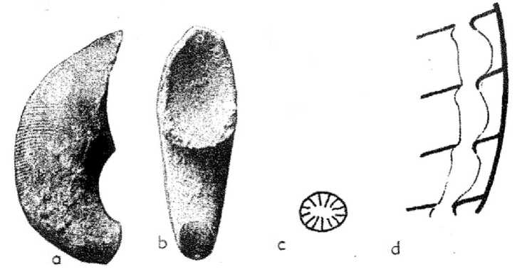
Fig. 3. Karoceras typicum Foerste. A — dorsal view, b — lateral view, c — dorsoventral section of the siphus, d — long section of the siphon [25, p. 314].
The Karocertidae family was identified by S. Teichert in 1939. Karoceratidae is a family of nautiloid mollusks from the order Oncocerida, characterized by straight or curved, laterally narrow shells and thin ventral siphuncles, which are empty, with the exception of Karoceras [25].
V.A. Rusanov proposed three subdivisions of the Silurian with characteristic fauna. The lowest layer is composed of dark-colored shales with shells of the new species Karoceras, the tri-lobites Dalmania caudate Emm., Proetus waigatschensis Tschera, and the brachiopods Orthis ben-nidens Hall, Strophodonta ampla Hall, Leptoena striata Hall, and Whitfieldella didyma Dalm. In the middle zone, a transition from shales to sandstone layers with a rich cephalopod fauna, 10–12 m thick, has been established. The Upper Silurian zone is represented by sandstones with an abun- dance of brachiopods: Whitfieldella didyma Dalm and, less commonly, Strophomena cuspidate Barr., S. stephani Barr., Spirifes parvulus Tschern., Rhynchonella minerva Barr., etc. Modern research has discovered almost all stages of the Upper Silurian [22].
The first discovery of Upper Devonian deposits also belongs to V.A. Rusanov. In 1909, he discovered Devonian mollusks of the genus Clyphioceras in Belushya Bay. In 1910, he discovered outcrops of Devonian rocks in Propashchaya and Arkhangelskaya Bays. He noted the Lower and Middle Devonian to the west of Neznaemy Bay, but the research of M. Lavrova in 1925 did not confirm this [26]. Later, researchers B. Chernyshev and B. Miloradovich confirmed the significant distribution of Lower Devonian deposits [27].
-
V .A. Rusanov discovered Lower and Middle Devonian limestones in an outcrop on the western shore of Neznaemy Bay. In these rocks, he found fossil remains of cephalopods of the genera Orthoceras, Trochoceras, Cyrtoceras, Nautilus , molluscs of the family Bellerophontidae , gastropods of the genus Pleurotomaria , gastropods of the genus Euomphalus , and corals of the genera Cyatophyllum, Favosites, and Aulopora [4].
In 1911, V.A. Rusanov, in his article “On the Lower Carboniferous and Upper Devonian Go-niatite Fauna Found on Novaya Zemlya”, provided a detailed description of Berkh and Lichutin Island [4]. He discovered and described the remains of cephalopods of the genera Clyphioceras and Orthoceras , brachiopods Productus, Martinia, Spiefer, Terebratula , and Atrypa , and bivalves of the genera Pecten, Enomphalus , and Bellorophon . He also discovered Devonian formations on the Five Finger Peninsula containing remains of coral polyps of the genera Alveolites and Favosites, and identified new species of brachiopods; however, their descriptions were not included in the article. From the Propashaya Bay, Samoyeds, on the instructions of V.A. Rusanov, selected fossil remains of cephalopods of the genera Trochoceras, Timanites, Orthoceras , Bactrites, Cyrtoceras, Platyostoma , and Pleurotomaria , which characterize the Devonian fauna of the bathyal facies. This allowed concluding that there was a similarity with the Domanik facies of the Timan Ridge and suggesting that it extended from Timan to Novaya Zemlya during the Devonian period. In Kresto-vaya Bay and Mashigin Bay, Carboniferous rocks with a rich fauna of productus were discovered for the first time.
-
V .A. Rusanov found Jurassic fauna in concretions of moraine deposits on the shores of the Admiralty Peninsula, in Krestovaya Bay, near Sukhony Nos, on Mityushev Island, in the western part of Matochkin Shar, in Gribovaya Bay, and in Rogachev Bay [4].
Today, these conclusions about the geology and history of development are outdated, but at that time they were the first ideas that provided the basis and allowed Soviet geologists to determine the direction of geological research on Novaya Zemlya.
On mineral resources on Novaya Zemlya
An article with this title was first published by V.A. Rusanov in the collection “Materials on the Exploration of Novaya Zemlya” in 1910 [9].
In the southern part of Novaya Zemlya, south of Matochkin Shar, Rusanov noted the prevalence of rich, marshy, herbaceous vegetation with peat bogs typical of the tundra. Light brown peat with preserved vegetation was also widespread. Rusanov clarified that the absence of shrubs and trees would encourage Novaya Zemlya colonists to exploit peat deposits as a fuel [9, p. 56].
During his expeditionary research, Rusanov noted rounded and unrounded pieces of coal along the banks and river valleys of Novaya Zemlya. He traced coal pebbles in the area of Neznaemy Bay to Krestovaya Bay. Only near the Matochkin Shar Strait, between Cape Stolbovogo and Gribovaya Bay, 12 km from the mouth of the Matochka River, he discovered primary coal deposits. These samples of light coal are housed in the Museum of Natural History in Paris and belong to the French Oceanographic Society. Analysis of the coal, which yielded approximately 55% carbon and 5% ash with a coke yield of 45%, allowed it to be classified as lignite. The widespread distribution and approximately uniform quality of coal on Novaya Zemlya made it possible to assume that that coal formation occurred simultaneously. Rusanov suggested a Quaternary age, in contrast to the views of Academician F. N. Chernyshev, who attributed it to Mesozoic coal [28]. Rusanov based his conclusions on differences in properties and conditions of occurrence. He established a Mesozoic age for the coal in concretions with Jurassic belemnites and ammonites. Quaternary coal in Krestovaya Bay formed thin interlayers, which Rusanov associated with algae and floating wood debris. He gave the same explanation for the origin of larger pieces of lignite found in association with Quaternary glacial boulders and clay. Rusanov gave the most complete description of the discovery of coal on Novaya Zemlya in his lecture, “Fossil Glaciers and Coal on Novaya Zemlya in Connection with the Geological Structure of the Island”, delivered at the general meeting of the Arkhangelsk Society for the Study of the Russian North on September 23, 1909. The printed lecture material is stored in the archives of the Academy of Sciences [4, pp. 234– 245]. Later, in the issue No. 8 of the journal “Izvestia of the Arkhangelsk Society for the Study of the Russian North”, Rusanov changed his view: he proposed a Quaternary age for the coal and a secondary nature of its occurrence as a result of the erosion and transport of older rocks containing lignite.
-
V .A. Rusanov noted the widespread distribution of iron ores, but pointed out their impractical significance. In particular, he pointed to the discovery of iron pyrite among Paleozoic shales. On the eastern side of Novaya Zemlya, he noted large outcrops of red ochre. They were discovered in the Matochkin Shar Strait in the summer of 1907.
Copper ores were traced in quartz-calcite veins on the northern side of Matochkin Shar, beneath Mount Sedlo. Malachite was discovered among the quartzites and sandstones of Mashigina Bay.
In 1907, cubic crystals of lead glance (galena) were discovered in the fragments of milky quartz on the northern side of Matochkin Shar. Rusanov was also searching for silver. It was already known that silver-lead ores were found at the southern tip of Novaya Zemlya. These ores were transported to Holland in the 17th century, where, on Witsen’s orders, they were studied and found to be unsuitable for mining [29]. However, V.A. Rusanov’s research did not confirm this fact. Later, silver ore deposits were discovered in the Mityushikha and Serebryanka Bays [29].
-
V .A. Rusanov noted the abundance of building stone: marble ranging from white and grey homogeneous to grey with white veins, and slate. He devoted special attention to diabase, considering it as a facing material. He noted the presence of asbestos and precious metals in association with diabases.
Conclusion
In recent years, the study of the history of scientific exploration of the northern and Arctic territories of Russia has become highly significant among scientists. State policy aimed at developing the Russian Arctic and North makes such research relevant. Such explorations reveal the complexity, labor-intensive nature, courage, and versatility of those who explore the North [1].
-
V .A. Rusanov’s contributions to geological exploration are undeniable. He was the first to describe and collect rock material in various areas of Novaya Zemlya, provide mineral prospecting forecasts, and assess the profitability of mining. Factual, archival, and published materials remain as evidence of V.A. Rusanov’s scientific research activities. He made both geological and geographical discoveries that filled in the blank spots on the map of Novaya Zemlya.
Many geographical objects on Novaya Zemlya are named in honor of the scientist: Rusanov Bay and Peninsula were named in 1927 by members of the expedition on the ship “Perseus”; Rusanov Bay, discovered by him in 1910, was named after him in 1925; in the same year, Mount Rusanov was named and a settlement of the same name was founded on the southern island of Novaya Zemlya. An icebreaker (1916) and a gas tanker (2018) were named after Vladimir Rusanov. Streets and lanes in Moscow, Severodvinsk, Arkhangelsk, Murmansk, and Pechora are named after the scientist. A monument to V.A. Rusanov in Pechora was erected in 1967 in memory of his work in the Pechora region.
Thus, Novaya Zemlya continues to attract the interest of many researchers and inquiring minds, drawing them in with its unexplored nature. V.A. Rusanov played a major role in the exploration of the Arctic, made a significant contribution to Arctic studies, and paved the way for subsequent geographical and geological discoveries on Novaya Zemlya.
