Early Iron Age pyramidal kurgans in Western Siberia

Author: Matveeva N.P.
Journal: Archaeology, Ethnology & Anthropology of Eurasia @journal-aeae-en
Section: The metal ages and medieval period
Article in issue: 1 т.47, 2019.
Free access
Short address: https://sciup.org/145145416
IDR: 145145416 | DOI: 10.17746/1563-0110.2019.47.1.073-082
Text of the article Early Iron Age pyramidal kurgans in Western Siberia
The idea of viewing the burial mound (kurgan) as an architectural structure is not new; it was expressed as early as the 19th century, and was followed up by M.P. Gryaznov (1961), his student M.P. Chernopitsky (1979, 1984), and other scholars. Extensive literature is devoted to the origins, evolution, and semantics of the kurgan tradition (Gimbutas, 1970; Shilov, 1995; Smirnov, 1997; Olkhovsky, 1999; and others). However, the structural system of burial sites has its own specific features in every archaeological culture, and these features should be considered in their own right. In particular, kurgans of the Early Iron Age in the forest-steppe zone of Western Siberia (Fig. 1, 1 ), on the northern periphery
of the Scytho-Siberian world, typically have a variety of ditches: concentric, arcuate, elliptical, and polygonal in plan view, both with sides of different lengths and with sides of equal lengths.
Ditches polygonal in plan view around the burials of the Sargatka culture were discovered in the early 1960s (Moshkova, Gening, 1972: Fig. 2). During the earlier archaeological studies, these were not completely unearthed. Excavations performed by the Tyumen Archaeological Expedition in the 1980s in elite kurgans on high floodplain terraces of the Tobol, Ishim, and Iset, and also on ridges and watersheds (all mainly on clay soils), have yielded a whole series of such observations (Matveeva, 1993: 13–43; 1994: 14, 26, 33, 47, 58, 70, 72, 81, 87). The initial explanation for the construction, by
0 2 m
0 2 m
0 2 m
Fig. 1. Location of sites of the Sargatka culture ( 1 ), and microrelief of the surface of kurgans 2 ( 2 ), 3 (3 ), and 6 ( 4 ) at the Gilevo-2 cemetery.
the Sargatka people, of the ditches polygonal in plan view was based on another very early observation concerning the structure of mounds over large kurgans (3–4 m high): these contained polygonal platforms of logs placed over the entire ground of the kurgan, on top of the buried soil, as a kind of structural variation of the Arzhan kurgan (Gryaznov, 1980: Ins.). Therefore, it was concluded that the ditches were dug out after the construction of such a platform, and surrounded it, protecting the entrance into the funeral space. The tomb of logs stayed open while the secondary burials were made in the kurgan, as evidenced by the location of discharged soil from the side-graves on the buried soil. Only later, when the related family group prepared to move away or achieved a different status, was this structure completed by the cover of sod bricks, and a new structure started (Matveeva, 1993: 135–136; 2000: Fig. 92).
The original appearance of the mound is unknown, but the reconstruction of the Kenes kurgan left by the early nomads in Northern Kazakhstan (Zdanovich, Ivanov, Khabdulina, 1984: Fig. 4) shows a stepped truncated cone made of sod blocks with clay crepidoma, which increased in diameter and decreased in height as the mound flattened with time. L.N. Koryakova is of the same opinion concerning the Sargatka kurgans (1988: 47). According to a series of research reconstructions, a Scythian kurgan constituted a sophisticated ensemble of a truncated conical mound erected from soil briquettes, with a menhir on top, crepidoma, ditch, stone rows, and accompanying commemorative structures (Olkhovsky, 1999: 125–126).
The Sargatka kurgans were also built of sod blocks cut around the burial space, as confirmed by the observations of differences in the thickness of buried soil inside and outside the burial ground. Initially, we described the appearance of the previously discovered Sargatka kurgans as a segment of a sphere, without focusing on details. Some deviations from the hemispherical shape were explained by the activities of grave-robbers. Moreover, Chernopitsky showed earlier that domed surfaces emerge naturally, under the influence of destructive forces transforming the initial body of the mound: in particular, the gravitational effect (1987: 60). However, the discovery of mounds with a truncated-pyramidal form (Matveeva, Zelenkov, Tretyakov, 2018: 46) makes the answer to the question of the external appearance of kurgans less obvious.
The goal of this study is to describe the elements of the Sargatka burial structures with ditches, and to identify the semantically significant relationships. We proceed from the understanding of a kurgan as a multi-functional structure, not only as a tomb, but also a memorial and ritual center reflecting the archaic system of world perception by means of objectified elements of the myth.
Sources
Currently, over 150 ordinary and elite kurgans have been excavated. Most of these were excavated as early as the 19th to the first half of the 20th century, when no observations were made on their structural system. The experience of excavating the Sargatka kurgans makes it possible to ascertain with confidence that there were almost no geometrically regular arcuate ditches. Such ditches occurred extremely rarely, usually in sandy soils, and were the results of the destruction of the original earth fences. In terms of the chronology of the burial structures, the ditches polygonal in plan view appear both at the earliest and the latest burial grounds (see Table ; Fig. 2–4).
Quantitative indicators of the Sargatka kurgans
|
Site |
Region |
Period |
Initial size of the ground, m * |
Initial shape of the ditch in plan view: number of sides |
Number of graves |
Changed size of the ground, m |
Changed shape of the ditch in plan view: number of sides |
|
1 |
2 |
3 |
4 |
5 |
6 |
7 |
8 |
|
Iskrovsky |
Tobol |
Early |
20 |
11 |
1 |
– |
– |
|
Suerka |
″ |
″ |
11 |
11 |
1 |
– |
– |
|
Krasnogorsky-1, kurgan 3 |
″ |
″ |
17 |
14 |
1 |
– |
– |
|
″ kurgan 12 |
″ |
″ |
20 |
9 |
2 |
– |
– |
|
″ kurgan 17 |
″ |
Late 5th to 4th century BC |
26 |
14 |
1 |
– |
– |
|
Dolgy Bugor |
″ |
″ |
20 |
12 |
2 |
– |
– |
|
Rafailovsky |
″ |
Early |
15 |
11 |
3 |
– |
– |
|
Krasnogorsky Borok, kurgan 1 |
″ |
″ |
10 |
9 |
3 |
– |
– |
|
″ kurgan 2 |
″ |
″ |
13 |
12 |
2 |
– |
– |
|
Tyutrino, kurgan 6 |
″ |
″ |
22 |
13 |
3 |
– |
– |
|
″ kurgan 7 |
″ |
Middle |
20 |
14 |
4 |
– |
– |
|
″ kurgan 8 |
″ |
″ |
16 |
12 |
4 |
– |
– |
|
″ kurgan 9 |
″ |
″ |
22 |
9 |
1 |
– |
– |
|
″ kurgan 10 |
″ |
″ |
12 |
8 |
4 |
17 |
10 |
|
Savinovo, kurgan 1 |
″ |
″ |
14 |
13 |
3 |
– |
– |
|
″ kurgan 2 |
″ |
″ |
10 |
12 |
1 |
– |
– |
|
″ kurgan 3 |
″ |
″ |
31 |
10 |
? |
– |
– |
|
″ kurgan 6 |
″ |
″ |
18 |
9 |
2 |
– |
– |
|
Krasnogorsky-2, kurgan 1 |
″ |
″ |
33 |
8 |
5 |
– |
– |
|
Gilevo-2, kurgan 6 |
″ |
1st to 3rd centuries AD |
24 |
8 |
3 |
– |
– |
|
Ust-Tartas, kurgan 7 |
Baraba |
2nd to 1st centuries BC |
10 |
9 |
4 |
14 |
9 |
|
Markovo-1, kurgan 8 |
″ |
″ |
11 |
12 |
7 |
– |
– |
|
″ kurgan 25 |
″ |
″ |
8 |
9 |
1 |
– |
– |
|
Abatsky-1, kurgan 2 |
Ishim |
1st century BC to 1st century AD |
17 |
9 |
9 |
– |
– |
|
″ kurgan 1 |
″ |
″ |
14 |
11 |
10 |
– |
– |
|
″ kurgan 3 |
″ |
1st to 3rd century AD |
18 |
10 |
11 |
– |
– |
|
″ kurgan 4 |
″ |
Turn of the eras |
16 |
12 |
6 |
– |
– |
|
″ kurgan 5 |
″ |
1st to 3rd century AD |
15 |
10 |
10 |
– |
– |
|
Abatsky-3, kurgan 1 |
″ |
Late |
27 |
11 |
5 |
– |
– |
|
″ kurgan 2 |
″ |
″ |
13 |
11 |
11 |
22 |
14 |
|
″ kurgan 3 |
″ |
″ |
8 |
9 |
2 |
15 |
10 |
|
″ kurgan 4 |
″ |
″ |
10 |
12 |
9 |
14; 20 ** |
12 |
|
″ kurgan 5 |
″ |
2nd to 3rd century AD |
10 |
10 |
8 |
15 |
12 |
Table (end)
|
1 |
2 |
3 |
4 |
5 |
6 |
7 |
8 |
|
Tyutrino, kurgan 5 |
Tobol |
2nd to 3rd century AD |
10 |
7 |
2 |
13 |
7 |
|
Abatsky-3, kurgan 6 |
Ishim |
″ |
23 |
14 |
10 |
– |
– |
|
Tyutrino, kurgan 1 |
″ |
″ |
14 |
12 |
3 |
13 |
11 |
|
″ kurgan 2 |
″ |
″ |
18 |
8 |
2 |
20 |
8 |
|
″ kurgan 3 |
″ |
″ |
19 |
12 |
7 |
– |
– |
|
″ kurgan 4 |
″ |
Late |
15 |
12 |
4 |
– |
13; 14 ** |
|
Savinovo, kurgan 7 |
Ishim |
Late |
19 |
13 |
2 |
– |
– |
|
″ kurgan 5 |
″ |
″ |
14 |
8 |
5 |
21 |
10 |
|
Gaevsky-1, kurgan 3 |
Tobol |
Early–Late |
14 |
9 |
5 |
18 |
11 |
|
″ kurgan 4 |
″ |
″ |
15 |
10 |
3 |
– |
– |
|
″ kurgan 5 |
″ |
″ |
19 |
11 |
3 |
– |
– |
|
″ kurgan 6 |
″ |
″ |
14 |
11 |
6 |
– |
– |
|
Nizhneingalsky-1 |
″ |
Middle |
13 |
11 |
3 |
– |
– |
|
″ |
″ |
Late |
27 |
14 |
1 |
– |
– |
|
Starolybaevo-4, kurgan 31 |
″ |
″ |
10 |
9 |
11 |
11 |
12 |
|
″ kurgan 33 |
″ |
″ |
13 |
12 |
6 |
14; 15 ** |
12 |
|
″ kurgan 34 |
″ |
″ |
14 |
8 |
2 |
– |
– |
|
″ kurgan 35 |
″ |
″ |
13 |
11 |
1 |
– |
– |
|
″ kurgan 39 |
″ |
″ |
12 |
9 |
2 |
– |
– |
|
Sidorovka, kurgan 1 |
Irtysh |
″ |
20 |
11 |
2 |
24 |
12 |
|
″ kurgan 2 |
″ |
″ |
22 |
14 |
3 |
– |
– |
|
″ kurgan 3 |
″ |
″ |
24 |
11 |
3 |
– |
– |
|
″ kurgan 5 |
″ |
″ |
15 |
9 |
6 |
– |
– |
|
Isakovka-3, kurgan 1 |
″ |
Middle |
19 |
10 |
1 |
– |
– |
|
″ kurgan 2 |
″ |
″ |
10 |
11 |
7 |
– |
– |
|
Yavlenka, kurgan 1 |
Ishim |
Early |
17 |
6 |
1 |
– |
– |
|
Tatarka, kurgan 1 |
Irtysh |
″ |
55 |
7 |
2 |
– |
12 |
|
Kokonovka, kurgan 2 |
″ |
4th to 3rd century BC |
10 |
9 |
1 |
– |
– |
|
″ kurgan 3 |
″ |
″ |
10 |
10 |
3 |
– |
– |
|
″ kurgan 10 |
″ |
″ |
14 |
9 |
1 |
– |
– |
|
″ kurgan 11 |
″ |
″ |
10 |
10 |
1 |
– |
– |
|
″ kurgan 13 |
″ |
″ |
10 |
10 |
1 |
– |
– |
-420
-180
зШ
0 2 m
Burial 1
Burial 2 С
Burial 3
Burial 2
Burial 4
0 2 m
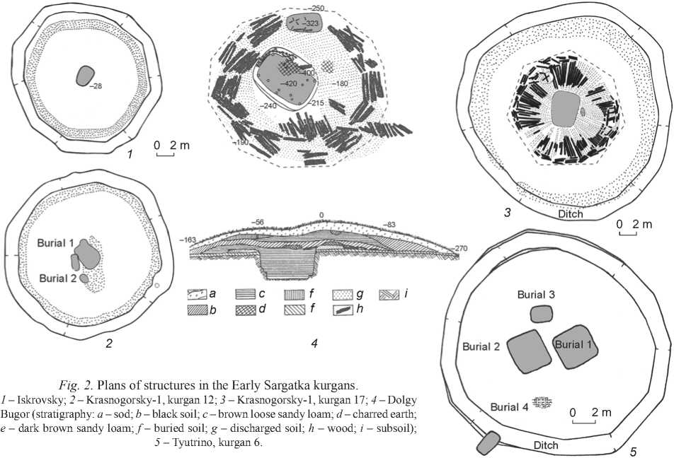
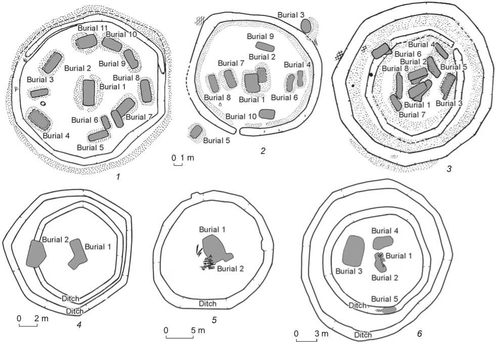
Fig. 2. Plans of structures in the Early Sargatka kurgans.
1 – Iskrovsky; 2 – Krasnogorsky-1, kurgan 12; 3 – Krasnogorsky-1, kurgan 17; 4 – Dolgy Bugor (stratigraphy: a – sod; b – black soil; c – brown loose sandy loam; d – charred earth; e – dark brown sandy loam; f – buried soil; g – discharged soil; h – wood; i – subsoil);
5 – Tyutrino, kurgan 6.
.Ditch / 0 2 m
Ditch
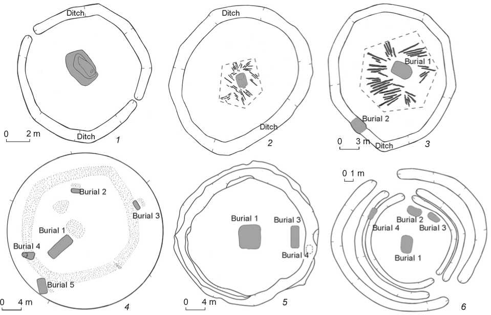
Fig. 3. Ground plans of structures in the Middle Sargatka kurgans.
1 – 3 – Savinovo: 1 – kurgan 2, 2 – kurgan 3, 3 – kurgan 6; 4 – Krasnogorsky-2, kurgan 1; 5 – Gilevo-2, kurgan 6; 6 – Ust-Tartas, kurgan 7.
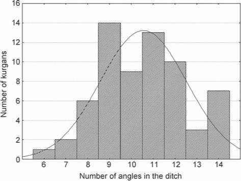
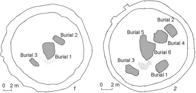
They have typically been found in cemeteries in the form of chains: that is, architectural ensembles with certain intervals and orientation, united by a single plan (for example, Tyutrino or Abatsky-3); they also appear at the burial grounds with compact planning, where several lines depart from the dominant kurgan (for example, Savinovo or Krasnogorsky-1, -2).
The exception to the majority of domed mounds was kurgan 1 at the Onufrievo cemetery on the Iset River, which has retained the shape of a truncated pyramid on the side opposite to the prevailing winds (Matveeva, 1982: 28), a height of 2 m, and a diameter of 30 m. However, by the time of excavation, its body had been demolished by bulldozers, and was used for
Burial 3
Burial 9
Burial 3
Burial 7
Burial 7/
Burial 10
Burial 4
Burial 5
Burial 5
1 m
Burial 4
Burial 2,
Burial 1
Burial 1
Ditch
Ditch
1. Burial 8. Burial 1 I
Burial 11 .Burial 10,
Burial 8 Burial 1 Burial 6
'— Burial 5
■Djtchi—
„ . . _ Burial 9 Burial 2
Burial 2
Burial 7 _ Burial 4
Burial 3 X-J , Burial 2
.'■V/-*'Burial 46^/y z^Burial 6 i V> / Burial У \ / Burial 8>>x X^Ditch^ -—Ditch. 2 m 3 m Burial 1 Burial 2 0 5 m Fig. 4. Ground plans of structures in the Late Sargatka kurgans. 1 – Abatsky-1, kurgan 3; 2 – Abatsky-1, kurgan 5; 3 – Abatsky-3, kurgan 5; 4 – Tyutrino, kurgan 5; 5 – Savinovo, kurgan 7; 6 – Savinovo, kurgan 5. filling the roadway; therefore, the microrelief of the surface could have not been recorded. While unearthing at the subsoil level, two concentric ditches polygonal in plan view (with no less than 10–12 angles; the exact shape could not be established, owing to the damage from construction works), with diameters of the circumscribed circles of 22 and 40 m, were discovered around the graves of this kurgan (Matveeva, 1993: 134). Only in 2017 did we manage to find several more truncated pyramidal kurgans at the Gilevo-2 cemetery, on the right bank of the Tobol River, near Zavodoukovsk (see Fig. 1, 2–4). Leveling of the excavations by 1 m before beginning to study three of them revealed the relief of the surface. All mounds were hexahedral. We may explain the relatively better preservation of the bodies of these kurgans (as compared to those located on arable land) by their location at the southern edge of the forest, which protected them from the prevailing winds, as well as the “phyto-factor” that created the “wire-mesh reinforcement” of the root system of shrubs and trees. Interestingly, in one kurgan of Gilevo-2, a closed ditch octagonal (8-angled) in plan view was found (see Fig. 3, 5); in another kurgan, an unclosed ditch; and in the third kurgan, there was no ditch, although the unearthed area was considerably larger than the mound, and an exploratory trench was made. Despite the clayish underlayer and the mound of dense black soil, the remains of log structures have not survived in the Gilevo kurgans. It turns out that the original shape of the mounds was determined by some other factors apart from the outlines of the platforms. Let us consider a sample of kurgans with well-recorded fences (65 units) from all local areas of the forest-steppe of Western Siberia, according to the published overviews (Moshkova, Gening, 1972: Fig. 1–2; Mogilnikov, 1972a: Fig. 2, 4, 6, 7; Polosmak, 1987: Fig. 4, 5, 8; Koryakova, 1988: Fig. 6–8; Kultura…, 1997: Fig. 2, 8, 11, 15; Matveeva, 1993; 1994; Matveeva, Volkov, Ryabogina, 2003: Fig. 36, 45, 50, 53, 56, 57; Matyushchenko, Tataurova, 1997: Fig. 3, 33, 41, 65; Pogodin, Trufanov, 1991: Fig. 1, 2), without claiming an exhaustive sampling of the source-base (see Table). Discussion Very few burial grounds have been excavated entirely or almost entirely; but in long-functioning kurgan ensembles, it was possible to establish the presence of cult structures, and see the places of ritual actions. This makes it possible to agree with Chernopitsky, who substantiated the idea of cult multi-functionality of kurgans (1979: 26). If the primary idea of enclosing the place of funeral rituals was embodied in the shapes of kurgan grounds, ditches, embankments, and mound structures, these shapes would have shown similarity, which generally has not been observed. In addition, kurgans erected on individual hills were not surrounded by ditches, as was the case with the Dolgy Bugor kurgan (see Fig. 2, 4) at the Krasnogorsky-1 burial ground, and kurgan 1 at Krasnogorsky-2 (see Fig. 3, 4), located in the Ugory locality, on separate hills, at a height of about 50–60 m above the river floodplain (Matveeva, 1993: 39–40). Ancient people might have assumed a natural protection in such cases. Yet, the idea of a polygonal structure under the mound is embodied in the first case in a dodecagonal (12-angled) log platform, and in the second case in the octagonal (8-angled) outlines of the embankment around the graves (there was no ditch at a distance of 4 m from the embankment, but it cannot be ruled out that it was located farther away and has not been unearthed). Let us try to determine whether there is a relationship between the number of angles in the ditch and the diameter of the ground or log structure, as well as relationship between the number of burials and the shape of the ditch. We have analyzed the specific features of ditches and kurgans in our sample on the basis of observations of their initial sizes, using Statistica.10 software. The correlation analysis has not revealed any dependencies between them (for example, the correlation coefficient between the number of angles in the ditch and the number of graves in the entire sample was 0.08, and –0.17 in the Tobol regional sample). Moreover, quantitative indicators were not distributed normally, which means that the sample was not random, but was dominated by the elite kurgans of the Tobol region, with their locally specific features. In the Tobol sample, just as in the general totality, the shape of kurgan grounds was regulated by some canons. The most common 9-, 10-, and 12-angled ditches in plan view were found in all areas and at all scales of construction work (Fig. 5). They might have embodied the idea of a quantitative aspect in the structural elements of the universe. Numbers divisible by two, three, and five were probably the most important as the most archaic, going back to natural units of counting; they appear in all ancient cultures. The predominant Eastern Iranian ethno-linguistic component in the Sargatka culture has been substantiated by a number of scholars, including the author of this study, by specific features of the funeral Fig. 5. Distribution of the Sargatka kurgans according to the shape of the ditch. rite and elements of the material culture (adornments and outfits) (Matveeva, 2000: 255–256). Therefore, we should point out that the most commonly used values in architectural structures, namely, multiples of three, four, five, and eight, symbolize the supreme deity, the creator of the world, and his main creations in the core of IndoEuropean religious beliefs (Toporov, 1994a). We should pay attention to hexagonal and heptagonal ditches in plan view, typical of single-grave kurgans (see Fig. 4, 4). In our opinion, these reflect a clearly expressed initial idea of ancient people about the shape of the structure above the grave as a six- or sevensided truncated pyramid, symbolizing the mythological mountain, the entrance to the Lower or Upper World, or something of the kind (Toporov, 1994c: 313). These ideas possibly go back to Indo-Iranian mythology, in which the four-part horizontal structure and the three-part vertical structure of the universe by summation or multiplication constitute the sacred numbers of 7 and 12 (Toporov, 1994b: 532). It cannot be excluded that in semantic terms, the ditch surrounding the hill above the grave resembled the serpent connecting and separating heaven and earth, as in archaic cosmogony myths, or guarding the entrance to the underworld as a chthonic symbol (Ivanov, 1994: 469). Subsequently, with the increase in the size of the entire structure, in order to emphasize the higher status of the persons buried in the kurgans, the initial values of 5, 6, and 7 were doubled. The doubling of the initial proportions can probably be explained by the desire to express the planning unity of the architectural structure in all of its elements. For example, in kurgan 17 at Krasnogorsky-1, the log platform had seven sides, while the ditch, which was at a distance of twice the platform’s radius, had a 14-angled shape (see Fig. 2, 3). In kurgan 3 at Savinovo, the disintegrated logs’ placement can be reconstructed as pentagonal, judging by the outlines of sectors with relatively equal areas, formed by decayed wood, and the ditch can be reconstructed as decagonal in plan view (see Fig. 3, 2). In kurgan 6 of the same burial ground, the platform had six sides, and the ditch was made at a distance twice as large as the platform’s radius to the west, and 1.5 times as large to the east, forming a 9-angled figure (see Fig. 3, 3). The transition to multiple graves in the burial complexes of the Late Sargatka period has already been noted in the literature (Mogilnikov, 1972b: 71). This process led to the original planning of a structure as a single “burial vault” for a group of persons of varying status. Therefore, two trends can be discerned in the architectural and planning solutions of the Middle and Late Sargatka periods. One trend was to maintain the original area and configuration of the burial site, as was the case, for example, at Tyutrino, Gilevo-2, Ust-Tartas, and Abatsky-1, embodied in renewing the ditch or repeating the previous shape with new fences (see Fig. 2, 5; 3, 5, 6; 4, 1, 2). The other trend maintained the tradition of demonstrating the status of an outstanding personality in labor costs for construction, and was expressed in increasing the site and surrounding it with a new ditch, which might have resulted from additional filling of the mound. The latter trend can be recorded only in unplowed above-the-grave structures. For example, in kurgan 5 at Abatsky-3, the initial 10-angled fence was replaced by a 12-angled fence; in kurgan 5 at Savinovo, the 8-angled ditch in plan view was supplemented with a 10-angled ditch with a diameter 1.5 times as large as the inscribed circle (see Fig. 4, 3, 6). How did the 11-angled and 13-angled configurations, which are also common, come about? We dare to assume that there could have been a deliberate summation of particularly important numbers of 5 and 6, as well as 6 and 7, which had been incorporated into the initial architectural design; but most likely there was a deviation from the plan due to the changes in the appearance of the structure and its purpose during use. For example, the ditch around the single-grave Iskrovsky kurgan forms an irregular 11-angled figure, in which two opposite sides (northern and southern) are 2–3 times shorter than other sides (see Fig. 2, 1). This could have resulted from the removal of two symmetrical bulkheads, which were initially left for entering the 9-angled ground of the burial, after the completion of construction. The ditch of kurgan 6 at Gaevsky-1 also has an 11-angled shape in plan view and short walls opposite to the late burials 2 and 3, located along the NE-SW line (Fig. 6, 2), possibly in the places of the previous gaps in the fence for entering the space under the mound, for performing secondary burials (Kultura…, 1997: Fig. 15). One short side on the southeast in the 11-angled configuration of the ditch in kurgan 5 of the same necropolis may indicate that the entry to the 10-angled kurgan’s ground once existed there, since a pot stood at each of the three graves located along the NE-SW line; at the extreme graves, the pots stood in the area of the ditch, which was deepened, closest to the graves (Fig. 6, 1). The fence in kurgan 1 at Savinovo seems to be an example of an unfinished construction. This is a 13-angled fence with three bulkheads on the northwest, southeast, and south, in approaches to the graves (Matveeva, 1993: Fig. 3). Moreover, if the entrance to the ground had to be closed, then two narrow gaps would have been dug off along a straight line, and for connecting the ends of the ditch in place of a wide bulkhead, it would have been necessary to make a turn, which would have given the ditch the 14-angled shape in plan view. Ditches surrounding the burial space, including those with several gaps, are known from the Don region and Volga region of the Early and Middle Bronze Age (Medvedev, 2017: 116), and the Urals and Siberia of the Late Bronze Age (Arkaim…, 2002: Fig. 7; Mikhailov, 2001: 191–193, pl. 32). Specialists have interpreted them as a reflection of the mythological serpent (Shilov, 1995: 565) or manifestations of the solar cults (Medvedev, 2017: 115). Fig. 6. Ground plans of kurgans 5 (1) and 6 (2) at Gaevsky-1. Using representative Scythian sources, V.S. Olkhovsky has convincingly shown that the structure of burial mounds among the early nomads of the Eurasia steppe was a canonized model of the universe’s structure, using strictly prescribed architectural elements, which were considered to be the procedural steps of the ritual, symbolically embodying the obstacles on the way of the deceased to the afterlife (1999: 123–125). Olkhovsky has found the Indo-European conceptual basis in the core of this myth, supplemented by an emerging epic tradition reflected in ritual acts (Ibid.: 119). The common Scythian links, similar to the myths of the Sargatka population, included the World Mountain; concentric zones in the kurgan space, dividing the “horizontal world”; the ditch; and the remains of sacrifices, including dependent people and horses at the hitching posts (Matveeva, 2000: 179, 229, 266). The vertical axis of the entire complex was probably marked by a giant pillar set in the mound or in the central pit, and sticking out to the surface, as was discovered in kurgan 3 at Savinovo (Matveev, Matveeva, 1991: 39). A sign of the mythological understanding of construction activities, and their assimilation to creation, was the custom of burying woodworking tools (celts, adzes) in the Sargatka graves. This practice finds its parallels among the early nomads of the Semirechye (Akishev, 1984: 10). Important differences in structural design and sacrifices in the Scythian and Sargatka cultures can be explained by local interpretations of the common myth in remote parts of Eurasia, and local building traditions based entirely on wood in the absence of stone materials. For example, values relating to the length of log blanks used in residential architecture began to be used (Matveeva et al., 2005: 111, 113); the rituals involving horses also underwent significant changes. The number of graves in a kurgan, as is known, was determined by the factors of social hierarchy and duration of residence of the family-related groups in the same place (Matveeva, 2000: 132–133). In their study, V.I. Matyushchenko and L.V. Tataurova proposed the idea that several ditches (or the renewal of the initial ditch with a change in its shape) were associated with successive secondary burials of high-status adult men in the kurgan (1997: 95–96). However, it was not possible to confirm this hypothesis, owing to the lack of sex- and age-definitions of skeletons from the graves, as well as of detailed data on the relief of the ditches at many Sargatka sites. In addition, there are cases of burials of high-status women in the centers of kurgans, with weaponry, cult items, precious implements, and adornments. We believe that the interpretation of ditches as a protective fence against the powerful forces of death, and possible magical harmful effects of the hero, who had become a member of influential ancestors, will be confirmed by facts in the future. This interpretation is consistent with the archaeological evidence of the Sargatka culture, testifying to the elevation of chiefs and legendary warriors, such as elite kurgans, adornments remaining from outfits of the “golden man” found in them, large sets of weaponry, precious sets of dishware, felt carpets and cauldrons as symbols of military feasts for the members of the retinue, and the subjects of representations on the items of the Siberian Collection of Peter I with the feats of mighty warriors (Matveeva, 2000: 238, 266). This interpretation also correlates with the idea of the hero’s afterlife journey, repeating the actions of the ancestors. Conclusions The preservation of some elements of the early IndoEuropean mythology in the kurgan architecture of the Early Iron Age in Western Siberia, including the concepts of the World Mountain, the myth of fighting with the serpent with the participation of Indra, or the posthumous journey would have been very doubtful if it were not for numerous evidences on the emergence of the Sargatka culture on the basis of the Late Bronze cultures of the Andronovo sequence, and the toponymic evidence of the Indo-European settlement in this region. Of course, there was a significant transformation of architectural tradition under the influence of factors emerging in a new chronological period. There are prospects for a detailed study of the issue described, using planigraphic and stratigraphic evidence from the most thoroughly performed excavations.