Ecological Status and Conservation of Natural Forage Areas in the Nakhchivan Autonomous Republic

Author: Isgandarova U.
Journal: Бюллетень науки и практики @bulletennauki
Section: Сельскохозяйственные науки
Article in issue: 1 т.12, 2026.
Free access
The article investigates the distribution, degradation status, and conservation measures of natural forage areas, such as meadows and pastures, which constitute the main fodder base for livestock farming in the Nakhchivan Autonomous Republic. It is noted that improper and uncontrolled use of these areas has led to changes in the botanical composition of meadows and pastures, as well as degradation of soil and vegetation cover. In this context, the efficient and sustainable use of natural forage lands in agriculture is of great importance. The study reveals that meadows are mainly located in the subalpine grasslands of mountainous regions and river valleys; summer pastures are situated in the alpine meadow zone, while winter pastures occupy the semi-desert zone of the Araz plain. The total area of natural forage lands in the Autonomous Republic amounts to 82,532 hectares, of which 3,177 hectares are meadows, 9,228 hectares are summer pastures, and 70,127 hectares are winter pastures. Intensive use of pasture lands has resulted in soil compaction due to trampling; in summer pastures, the turf layer has been damaged, and soil erosion and degradation have been observed. In winter pastures, the spread of weed species and soil salinization have increased. Currently, 7,325 hectares of summer pastures and 56,642 hectares of winter pastures have become unsuitable for agricultural use. Overall, 63,967 hectares (approximately 80%) of natural forage lands are assessed as degraded pastures. This trend contributes to landscape deterioration, loss of biological diversity, and an increased risk of desertification. Therefore, the protection, restoration, and sustainable use of natural forage resources require the implementation of comprehensive measures. The article also proposes specific recommendations aimed at preventing the degradation of meadows and pastures.
Nakhchivan ar, summer pasture, winter pasture, meadow, degradation
Short address: https://sciup.org/14135538
IDR: 14135538 | UDC: 631.432: | DOI: 10.33619/2414-2948/122/33
Экологическое состояние и меры по охране естественных кормовых угодий Нахчыванской автономной республики
Исследуются распределение, состояние деградации и меры по сохранению естественных кормовых угодий, таких как луга и пастбища, которые составляют основную кормовую базу для животноводства в Нахчыванской Автономной Республике. Отмечается, что ненадлежащее и бесконтрольное использование этих территорий привело к изменению ботанического состава лугов и пастбищ, а также деградации почвенного и растительного покрова. В этом контексте эффективное и устойчивое использование естественных кормовых угодий в сельском хозяйстве имеет огромное значение.Исследование показало, что луга в основном расположены на субальпийских лугах в горных районах и речных долинах; летние пастбища расположены в зоне альпийских лугов, в то время как зимние пастбища занимают полупустынную зону Аразской равнины. Общая площадь естественных кормовых угодий в Автономной Республике составляет 82 532 га, из которых 3 177 га - луга, 9 228 га - летние пастбища и 70 127 га - зимние пастбища.Интенсивное использование пастбищных угодий привело к уплотнению почвы из-за вытаптывания; на летних пастбищах поврежден слой дерна, наблюдаются эрозия и деградация почвы. На зимних пастбищах усилилось распространение сорняков и засоление почвы. В настоящее время 7 325 га летних пастбищ и 56 642 га зимних пастбищ стали непригодными для сельскохозяйственного использования. В целом, 63 967 га (примерно 80%) естественных кормовых угодий оцениваются как деградированные пастбища. Эта тенденция способствует ухудшению ландшафта, утрате биологического разнообразия и повышению риска опустынивания.Таким образом, защита, восстановление и устойчивое использование природных кормовых ресурсов требуют принятия комплексных мер. В статье также предлагаются конкретные рекомендации, направленные на предотвращение деградации лугов и пастбищ.
Text of the scientific article Ecological Status and Conservation of Natural Forage Areas in the Nakhchivan Autonomous Republic
Бюллетень науки и практики / Bulletin of Science and Practice
UDC 631.432: 502.211:582(479.242)
Although modern science and technology have made significant advances in all fields, soil remains an indispensable resource for the production of agricultural goods, which constitute the primary source of food for humanity. The value of soil resources is determined not only by their productivity but also by the essential role they play within ecosystems. From this perspective, the proper and scientifically grounded use of soil is of strategic importance for ensuring food security and maintaining ecological balance [1].
The Nakhchivan Autonomous Republic possesses favorable natural geographical conditions and substantial potential for the development of agriculture. The region’s mountainous and foothill areas, fertile soil types, and climatic diversity create broad opportunities for agricultural development, particularly livestock farming. Enhancing soil fertility, preventing erosion and salinization processes, and strengthening the fodder base for livestock are among the key prerequisites for ensuring the sustainability of agricultural production in the region [2].
Materials and methods
In accordance with the scientific-theoretical framework and methodology of the research objectives, the study was conducted in three stages: preparatory, fieldwork, and generalizing. During the fieldwork stage, visual observations were carried out in selected areas, along with assessments of biodiversity and the collection of data on the current state of soil and vegetation cover. The field investigations employed methods such as stationary observation, diagnostic analysis, vegetation assessment, recording of degradation indicators, and photo documentation. At this stage, areas of natural forage lands, particularly pastures and meadows that had undergone degradation due to intensive grazing, were identified, and changes in vegetation cover and declines in productivity were documented [3].
During the generalizing-concluding stage, the collected data were systematized and subjected to scientific analysis. The results were interpreted using mathematical–statistical and cartographic methods. For the digital processing and analysis of data, ArcGIS software, remote sensing technologies, and various internet resources were extensively utilized. As a result, the levels, causes, and spatial distribution of degradation in natural forage resources were determined, and scientifically grounded recommendations for their protection and restoration were proposed.
In the office-preparatory stage, existing literature, scientific sources, maps, and statistical data were collected and preliminarily analyzed. The research directions were identified, and the study sites were selected and georeferenced. At this stage, the distribution characteristics of natural forage areas were also initially analyzed using ArcGIS and other geographic information systems [4].
Thus, the research was conducted through a comprehensive methodological approach, integrating both field observations and multifaceted analyses based on modern information technologies.
Results and discussion
The total land fund of the Nakhchivan Autonomous Republic amounts to 550,275 hectares. Of this area, 190,023 hectares are state-owned, 303,726 hectares belong to municipalities, and 56,526 hectares are privately owned. A total of 177,382 hectares of the land fund are classified as agricultural lands. These include 54,857 hectares of croplands, 2,042 hectares of perennial plantations, 32 hectares of fallow lands, 3,177 hectares of meadows, and 104,429 hectares of grazing and pasture lands. Additionally, 63,967 hectares of summer and winter pastures are considered unsuitable for agricultural use, indicating the extent of pastureland degradation. Household plots in private ownership cover a total area of 14,488 hectares. Other land categories include forests and shrublands (4,750 ha), swamps and reed beds (47 ha), water-covered lands (18,641 ha), areas under transportation infrastructure (5,867 ha), as well as ravines, gullies, valleys, sandy areas, rocky and gravelly terrains, saline soils, and other unused lands (260,419 ha). Cemeteries occupy 397 hectares, while construction sites encompass 4,079 hectares .
Natural forage resources primarily include meadows, summer and winter pastures, as well as grazing lands. In the territory of the Autonomous Republic, meadows are mainly found in river valleys and the subalpine meadow zones of mountainous regions. These areas are characterized by moist and fertile soils and are mainly used for producing winter fodder reserves [2]. According to the official information of the Cabinet of Ministers as of January 1, 2024, the total area of meadows in the region is 3,177 hectares.
Summer pastures are typically distributed across mountainous areas located at elevations of 2,200–2,400 meters. These areas receive relatively high annual precipitation and are especially widespread around Batabat Lake, the Bichanak Pass, and the villages of Bist, Tivi, Parağa, and nearby settlements [1].
Summer pastures are characterized by perennial, low-growing plant species closely integrated with the soil, whose root systems provide strong resistance to erosion. These pastures are typically used intensively from May until the end of September [3].
According to the 2024 land balance approved by the Cabinet of Ministers of the Nakhchivan Autonomous Republic, summer pastures cover a total of 9,228 hectares [7]. Only 1,903 hectares (20.6%) of this area are suitable for agricultural use, while 7,325 hectares (79.4%) are classified as degraded pastures. The suitability of summer pastures for agricultural use is unevenly distributed across administrative districts. The largest areas of summer pastures are found in Kangarli (3,475 ha), followed by Shahbuz (2,161 ha), Babek (1,473 ha), Sharur (1,425 ha), and Ordubad (694 ha). Kangarli (2,691 ha) and Shahbuz (1,815 ha) districts also contain the largest areas of degraded summer pastures (Table 1). It should be noted that summer pastures are entirely absent in the territories of Sadarak and Julfa districts, which can be explained by factors such as topography, climate, and soil–economic conditions. The data presented not only reflect the presence of summer pastures but also provide an important basis for assessing their ecological status, geobotanical potential, and suitability for economic use [6].
Table 1
DISTRIBUTION AND CONDITION OF SUMMER PASTURES
IN THE NAKHCHIVAN AUTONOMOUS REPUBLIC
|
Name of District |
Total Pasture Area |
Suitable Pasture Area |
Degraded/Unsuitable Pasture Area |
|
Shahbuz |
2161 |
346 |
1815 |
|
Kangarli |
3475 |
784 |
2691 |
|
Ordubad |
694 |
111 |
583 |
|
Babek |
1473 |
236 |
1237 |
|
Sharur |
1425 |
426 |
999 |
|
Total: |
9228 |
1903 |
7325 |
Note: The table is compiled based on the Decision of the Cabinet of Ministers of the Nakhchivan Autonomous Republic on the approval of the land balance as of January 1, 2024
Winter pastures are primarily located within semi-desert landscapes and constitute essential natural forage resources for livestock farming in the Nakhchivan Autonomous Republic. These pastures are widely distributed across areas such as the Araz plain, Boyukduz, the Tananam sloping plain, the Duzdagh sloping plain, the southern part of the Jahri escarpment, and the Lizbirt depression [5].
According to official data, the total area of winter pastures in the Autonomous Republic is 70,127 hectares. Of this, only 13,485 hectares (19.2%) are suitable for agricultural use, while 56,642 hectares (80.8%) fall into the category of degraded or unsuitable pastures. The period of use for winter pastures typically begins in October and continues until April–May. This period is crucial for livestock overwintering and fodder supply. The suitability of winter pastures for agricultural use is also unevenly distributed across administrative districts. With the exception of the Shahbuz district, all other administrative regions contain winter pasture areas. The largest winter pastures are located in the Sharur district (30,737 ha), of which 27,230 hectares are unsuitable. In the Sadarak district, 13,142 hectares of winter pastures exist, 10,416 hectares of which are degraded. In the Babek district, 8,717 hectares out of 12,501 hectares are unsuitable; in the territory of Nakhchivan, 3,468 hectares out of 4,849 hectares; in the Kangarli district, 1,764 hectares out of 3,223 hectares; and in the Ordubad district, 1,982 hectares out of 2,210 hectares are degraded (Table 2).
Table 2
GEOGRAPHIC DISTRIBUTION AND SUITABILITY STATUS
OF WINTER PASTURES IN THE NAKHCHIVAN AUTONOMOUS REPUBLIC, ha
|
Name of District |
Total Pasture Area |
Suitable Pasture Area |
Degraded Pasture Area |
|
Sadarak |
13142 |
2726 |
10416 |
|
Kangarli |
3223 |
1459 |
1764 |
|
Ordubad |
2210 |
228 |
1982 |
|
Babek |
12501 |
3784 |
8717 |
|
Julfa |
3465 |
400 |
3065 |
|
Nakhchivan |
4849 |
1381 |
3468 |
|
Sharur |
30737 |
3507 |
27230 |
|
Total: |
70127 |
13485 |
56642 |
Note: The table is compiled based on the Decision of the Cabinet of Ministers of the Nakhchivan Autonomous Republic on the approval of the land balance as of January 1, 2024
Using the collected statistical data, ArcGIS software, remote sensing technologies, and online resources, a map reflecting the geographical distribution and suitability status of pastures within the territory of the Autonomous Republic was prepared (Figure).
Based on the available data and the analysis of statistical tables, approximately 80% of summer and winter pastures in the Nakhchivan Autonomous Republic are currently unsuitable for agricultural use. This situation has developed as a result of the combined influence of several natural and anthropogenic factors. In recent decades, climate change has led to increased aridity in the region, uneven distribution of precipitation, and reduced soil moisture, all of which have contributed to the weakening of vegetation cover. In addition, improper use of certain summer and winter pastures, premature mowing of meadow areas, and overgrazing – factors directly linked to human activity – have further accelerated soil and vegetation degradation.
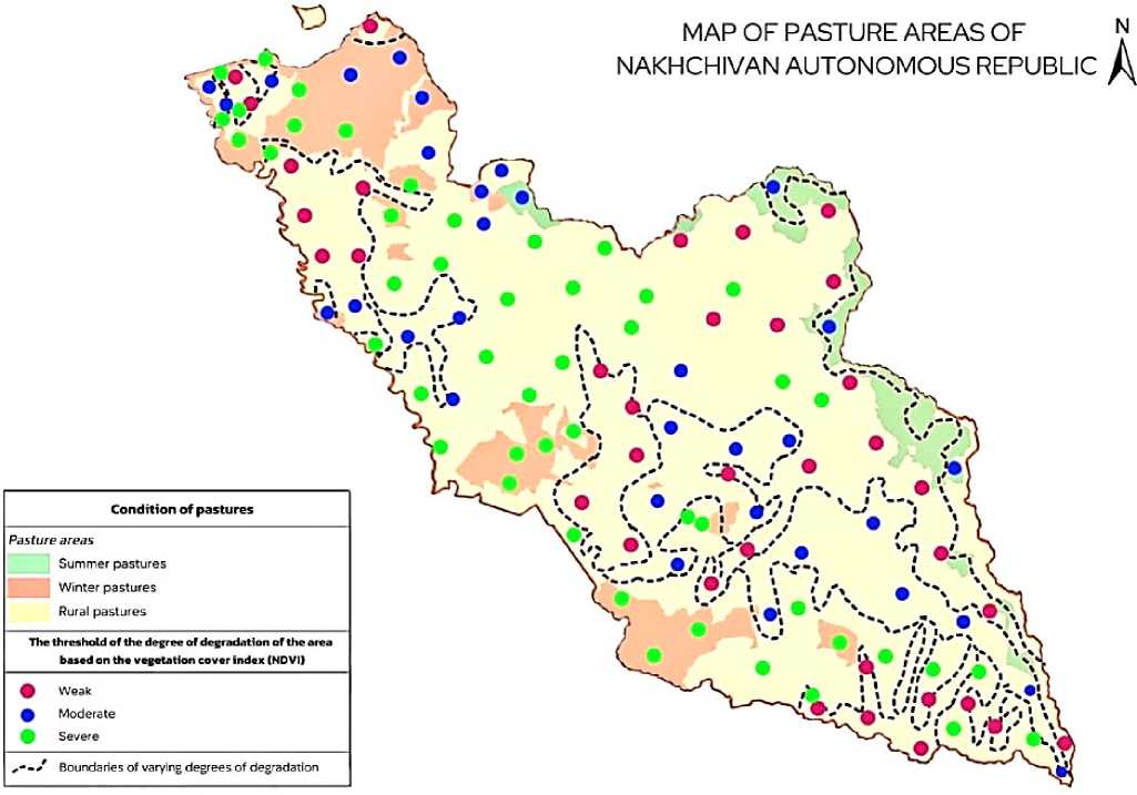
Figure. Pasture map of Nakhchivan Autonomous Republic
Excessive grazing on summer pastures damages the root systems (turf layer) of forage plants and causes surface compaction, ultimately rendering these lands incapable of natural recovery. Winter pastures, which already possess weak vegetation cover, become increasingly dominated by weeds under intensive grazing, leading to reduced species diversity and declining biological richness. Premature mowing of meadows prevents plants from producing seeds, thereby limiting natural regeneration in subsequent years.
As a consequence of these processes, disturbances occur in the natural landscape structure, the fertility potential of pastures declines, the risks of erosion and desertification increase, and the ecological balance of the region is disrupted. To prevent pasture degradation and enhance the productivity of natural forage lands, the following measures are essential:
-
- Grazing regimes for summer and winter pastures must be scientifically regulated, ensuring a balance between livestock density and pasture capacity to prevent overloading. This would help protect the turf layer and facilitate vegetation restoration.
-
- Sowing forage crops suited to local soil and climatic conditions (e.g., alfalfa, meadow grasses, white clover) should be encouraged. This would improve species composition and enhance the quality of the fodder base.
-
- Irrigation possibilities should be explored in natural meadows and hayfields to increase productivity, and modern irrigation technologies suitable for local conditions should be implemented.
-
- Environmental and legal awareness programs should be conducted among the population and farming communities to foster ecological responsibility and sustainable use of natural resources.
-
- Artificial rainfall technologies may be considered in lowland and foothill areas to improve microclimatic conditions, supporting both livestock health and the development of forage vegetation.
-
- Long-term monitoring and geobotanical observations should be employed to regularly assess pasture conditions and develop sustainable management plans.
The implementation of these measures would support the restoration, productivity enhancement, and sustainable use of natural forage resources in the Nakhchivan Autonomous Republic—an outcome of strategic importance for ensuring ecological security and promoting the region’s agricultural development.
