First Evidence of Pleistocene Archaeology on the Neyshabur Plain and its Role in Reconstructing the Dispersal of Hominins on the Northeastern Iranian Plateau

Author: Sadraei A., Garazhian O., Sabori H.
Journal: Archaeology, Ethnology & Anthropology of Eurasia @journal-aeae-en
Section: Paleoenvironment, the stone age
Article in issue: 3 т.49, 2021.
Free access
The northeastern Iranian Plateau is considered a leading region in Paleolithic studies. The history of Paleolithic research in this region dates back to the mid-20th century. However, unlike the western and, to some extent, the central part of the Iranian Plateau, only a handful of sites have been identifi ed in the northeastern part. Field studies conducted on the Neyshabur plain have provided some of the only Paleolithic evidence at four locations in the foothills of the Binalud Mountains: Dar Behesht, Mushan Tappeh, Ali Abad, and Qezel Tappeh. Our research aims to assess this evidence, provide a revised typology of Pleistocene artifacts from the Neyshabur plain, and also study the role of these and other fi nds in the area and analyze their signifi cance in terms of the dispersal of Pleistocene hominin populations. We propose two main corridors on the northeastern Iranian Plateau assumed to have been infl uential in the dispersal of human ancestors.
Neyshabur plain, Pleistocene, northeastern Iranian Plateau, Paleolithic, hominin populations
Short address: https://sciup.org/145146303
IDR: 145146303 | DOI: 10.17746/1563-0110.2021.49.3.003-012
Text of the scientific article First Evidence of Pleistocene Archaeology on the Neyshabur Plain and its Role in Reconstructing the Dispersal of Hominins on the Northeastern Iranian Plateau
Looking at Southwest Asia, one can clearly perceive the importance of the Iranian Plateau in this geographical area. On the one hand, being located north of the Strait of Hormuz and the Arabian Peninsula, and along its coastline with the Indian subcontinent, it acted as a migration bridge for the southern parts of Asia; and on the other hand, by having a water barrier in its northern part, it has been indeed a really important passageway in the distribution of Pleistocene hominids to other parts of Asia. However, studies in this vast area have been, to a large extent, vague and unfocused.
In Kuldara, southern Tajikistan, an 800,000-year-old lithic industry has been recovered (Ranov, Carbonell, Rodriguez, 1995). On the other side of the Caspian Sea, one witnesses the presence of subspecies of Homo erectus in Dmanisi, Georgia, a place that is more than 1.8 million years old and presents one of the oldest human remains and chopper industries (Lordkipanidze et al., 2013). Evidence of the first human populations has also been found in Turkey (Slimak et al., 2008). In the Levant and in Ubeidiya, well-preserved archaeological and human remains from at least 1.2 million years ago are observed (Belmaker et al., 2002). In the site of Gesher Benot Ya’aqov (Israel), dating to ca 800 ka BP,
The Arabian Peninsula, located between the two key straits of Bab-el-Mandeb in its southwest and Hormuz in its northeast, has played a key role in expanding the territory of hominids to parts of South Asia (Rose, Petraglia, 2009: 10). This issue becomes much more important owing to its proximity to the eastern and southeastern parts of the Iranian Plateau. Nevertheless, the evidence presented to date from the early lithic industries in this area is uncertain, and a significant portion of our information from the Lower Paleolithic period is obtained from surface surveys (Biglari, Shidrang, 2006: 167). However, it should not be forgotten that a significant part of these studies is limited to the Zagros, Alborz, and the Central Iranian Plateau, and the eastern part of Iran has practically been unstudied.
Nonetheless, during the last decade or so, some evidence, albeit limited, from the northeast of the Iranian Plateau has been reported (Coon, 1951: 20; McBurney, 1964; Ariai, Thibault, 1975: 106). Also, some recent surface sites have been reported (Barfi, Soroush, 2014; Barfi, Zafaranlou, Soroush, 2014; Nikzad, Sedighian, Ghasemi, 2015, Sadraei, Mehne, Saburi et al., 2017; Sadraei, Mehne, Toghraei et al., 2018; Sadraei, Anani, 2018; Sadraei, Mehneh, Sheikh et al., 2019). In the Neyshabur plain survey project, open-air Paleolithic sites were found, including Dar Behesht, Ali Abad, Mushan Tappeh, and Qezel Tappeh. This study introduces the sampled lithic artifacts from these sites. The results of the typological analysis of the assemblages are presented. Comparative studies with adjacent sites are carried out, and the role of the above-mentioned Paleolithic sites in the reconstruction of patterns of hominids’ dispersal is considered.
Geomorphology of Neyshabur plain
The northeast of Iran is formed by several intermountain plains, of which Neyshabur plain is considered one of the westernmost (Rokni et al., 2016: 25). It is limited to the Binalud heights from the north, the heights of Neizehband, Siah Kuh, and Namak mountains from the south, the Milajough and Yalpalang heights from the east, the Sabzevar plain catchment from the west, and to the Jovien plain from the northwest (Fotohi et al., 2013: 65).
Paleozoic formations in Iran are quartz sandstones (Lalun formation), dolomitic and dolomitic lime and shill (Mila formation), marly limestone (Niur formation), limestone and dolomite (Bahram formation), and crystallized quartzite, which have outcrops in the north of the plain in the Binalud heights. Mesozoic formations include phyllite, light gray and light buff limestone (Jurassic). Tertiary geologic formations include shale and sandstone, conglomerate along with volcanic cobbles, marly limestone, light green cobbles, volcanic cuts, conglomerates, andesite and gypsum (Ibid.: 66). These formations cover most of the mounds in the catchment basin of the Neyshabur plain. The Quaternary period consists of alluvial sediments, wind sediments, and fluvial sands, covering most of the course of flood routes and the plain surface. The quartz material has provided a high potential for the formation of raw stone material in the study area (Ibid.).
Methodology and findings
The surveying operation of Neyshabur plain covered mainly the northern parts of the plain and the southern foothill areas of the Binalud mountain range. Our study was conducted as an intensive survey, which is the most efficient method for maximal identification of archaeological sites. At first, we dealt with identifying artifacts, and then managed to specify their distribution on the surface. If the distribution of the artifacts was significant, the necessary strategy for the sampling job could be chosen. In the end, sites that had at least 7 to 10 pieces of artifacts, with their applied technology partially identifiable, were determined as open-air sites (Fig. 1).
Generally, 37 archaeological sites were identified in the Neyshabur plain. In four locations, which are formed along the southern parts of the Binalud foothills, dispersions of lithic artifacts were identified. The sites are located at an elevation of more than 1400 m above sea level, at the entrance to the straits leading to intermountain valleys, on the top of mounds, so that their sediments have been greatly protected against the erosion processes of the Holocene period. The study area, covering parts of the Binalud highlands, has actually made it difficult to establish Paleolithic settlements at high altitudes owing to the young age of the heights and the low snowline in different Pleistocene periods. Of the four identified sites, one site can be attributed to the Lower Paleolithic period, and the other three to the Middle Paleolithic era.
Stone raw material
In terms of the composition of the stone raw material used in the collections identified in the Neyshabur plain, it can be stated that in all four assemblages the highest amount belongs to the flint group. Chert is the second raw material used in the knapping process of the artifacts. Quartz has the third frequency rate, and is most abundant in the Mushan Tappeh site. Jasper and tuff are other raw materials identified in the Paleolithic sites of Neyshabur plain. Jasper was identified only in Qezel Tappeh, and tuff was seen only in the Ali Abad site.
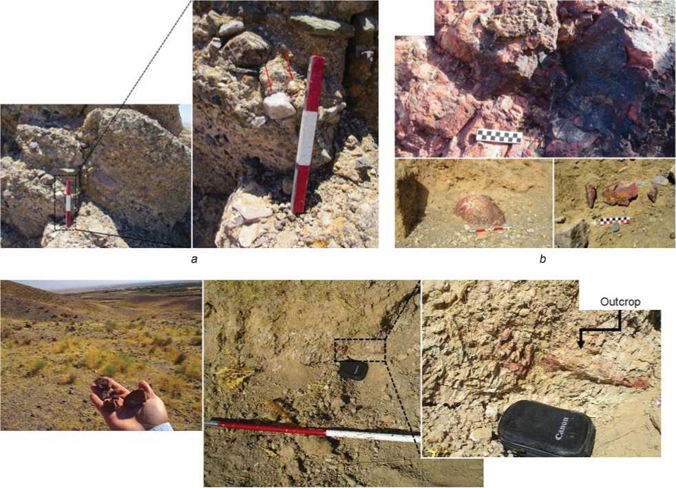
In the site of Qezel Tappeh and on the slopes of the hills, significant traces of chert were identified. Therefore, the accessibility of raw material seems to be the main factor in the formation of the Paleolithic industry at this location in the plain (Fig. 2, c ). Also, at the edge of the site of Ali Abad, a large stone block of chert can be observed (Fig. 2, b ). In addition, on the surface and adjacent parts of the site, chert cobble, as well as quartz and tuff pieces, can be seen in abundance.
Mushan Tappeh was another site where, owing to its location next to the geological conglomerate structures, there was a possibility of finding sources of stone raw material. Investigations showed the presence of quartz and flint among the natural cement textures of these structures (Fig. 2, a ), a finding that becomes more important in terms of the composition of the stone raw material in Mushan Tappeh collection. Finally, despite the surveys carried out on the site of Dar Behesht, no evidence indicating the existence of outcrops was identified, and only low-quality flint and quartz cobble were found, located mainly in the water stream near the site. In order to obtain more reliable information, four lithic artifacts, as well as four samples of stone raw material, from Paleolithic sites were sent to the laboratory of the Restoration Research Center of the Research Institute of Cultural Heritage in Tehran for sampling and petrographic studies.
Two samples (artifact and stone raw material) from Qezel Tappeh site were made of chert, containing the skeletal remains of marine organisms (Fig. 3, 1 , 2 ). The artifact from Dar Behesht site is made of quartz. (Fig. 3, 4 ). The raw stone sample from this site is composed of cryptocrystalline quartz mineral and microcrystalline quartz. In this sample, the iron oxide mineral background still exists sporadically and limitedly. Another ingredient is calcite, which is present in relatively coarse granular
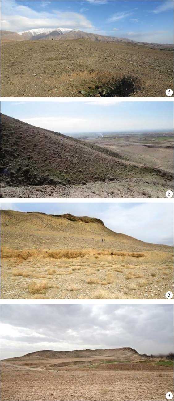
Fig. 1 . Sites identified in Neyshabur plain.
1 – Dar Behesht; 2 – Qezel Tappeh; 3 – Ali Abad; 4 – Mushan Tappeh.
c
Fig. 2 . Sources of stone raw material in Paleolithic sites of Neyshabur plain.
a – quartz and flintstone raw material among the cement texture of conglomerate parts; b – chert stone raw material identified in the vicinity of Ali Abad site; c – outcrops of chert at the Qezel Tappeh site.
form in silica paste. The frequency of calcite mineral makes up more than 10 % of the total sample volume (Fig. 3, 3). The raw stone sample from the Ali Abad site is composed of chert. It consists of large and separate pieces of silica, which are joined together by a secondary cement, consisting of iron oxide, silica, and calcite. These parts have sharp and angled margins, and the original rock was probably crushed by tectonic processes and reconnected by secondary processes and exposure to the new environment (Fig. 3, 5). The artifact from this site is made of chert, containing finegrained silica sand (Fig. 3, 6). The sample of raw stone from the Mushan Tappeh site consists of fine-grained quartz mineral and quartz cryptocrystalline. In this context, fine silica, large pieces of calcite mineral with various fossil remains can be seen. Lime and fossil pieces make up more than 50 % of the sample volume (Fig. 3, 7). The artifact from this site (Fig. 3, 8) is made entirely of quartz mineral. This example shows similarities with the two samples discovered in the Dar Behesht site.
The results of petrographic analysis, at least in the Qezel Tappeh site, show a completely similar stone raw material in the artifacts tested. Taking into account the existence of chert outcrop in the site, this largely reveals its main origin. The Ali Abad samples, considering the location of the site at the edge of the seasonal water flow, indicate the presence of the secondary bed here, which is evidenced by their components in the form of secondary cement. The similarity of raw stone samples from Dar Behesht and Mushan Tappeh suggests their common origin.
It can be argued that at Qezel Tappeh, Dar Behesht, and Mushan Tappeh, the source of raw material should be searched for in the sites themselves. Meanwhile, in the Ali Abad site, owing to its proximity to the seasonal flow, the probability of an external origin for raw material is high. This should be analyzed by conducting specialized lithological studies.
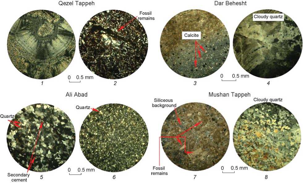
Fig. 3 . Thin cross-sections taken from samples of studied stone raw material.
The Neyshabur plain in the Paleolithic era
The open-air site of Mushan Tappeh is located on the northern edge of the Neyshabur plain, on the mounds to the south of the Binalud chains. The artifacts identified in this site include 13 pieces: cores (n=5), tools (retouched pieces, n=4), and debris (n=5). In the group of cores, there are a broken core, a tested core, a unifacial core, and a core that has undergone cortex removal using the anvil technique, which is evidenced by the traces of corrosion and abrasion left on its lower part (Fig. 4). Retouched tools include three sidescrapers (incl. a double-side scraper and a heavy-duty scraper) (Fig. 5, 2), and a chopper-core (Fig. 5, 1). The stone raw material used is flint, chert, and quartz. The degree of erosion of edges in some pieces can contribute to the comparative chronology of the said artifacts. In terms of the knapping technique used at the Mushan Tappeh site, two possible methods can be identified: that with a hard hammer (the most widely used), and the anvil technique. This latter technique was also used in the samples from the Kuldara (Davis, Ranov, 1999: 186) and Kashafrud sites (Jami Al-Ahmadi, 2008: 125). The poor quality of the cores, which greatly affected the knapping process, caused them to be used mostly for tool making. The absence of bifacial tools in the collection reinforces the likelihood that its industries may have been different from those at the neighboring sites. Bifaces have been reported from Kashafrud (Ibid.: 122) and many open-air sites in Turkmenistan (Vishnyatsky, Lyubin, 1995).
The collections of lithic artifacts from the Middle Paleolithic sites of Ali Abad, Qezel Tappeh, and Dar Behesht are small: 9, 13, and 14 pieces, respectively. The artifacts obtained from the open-air site of Dar Behesht include cores and the related pieces (n=3), flakes (n=4), formal tools (n=5), including a déjeté scraper (Fig. 5, 12 ), and debris (n=2). Ali Abad is another site with a higher proportion of formal tools (n=5) and retouched pieces (n=2). The Qezel Tappeh assemblage is dominated by flakes; cores are two, and formal tools are absent.
The general dimensions of cores were studied by two collections (Qezel Tappeh and Dar Behesht). Given the lack of some tool groups and the low density of the artifacts in these assemblages, drawing any conclusion with reference to the dimensions of the artifacts, their relation to the number of negative scars on the cores, or the presence of flakes would be impossible. The overall low dimensions of the artifacts indicate a lack of proper access to the raw stone material, and the cracks resulted from weathering show that the finds were not located in situ .
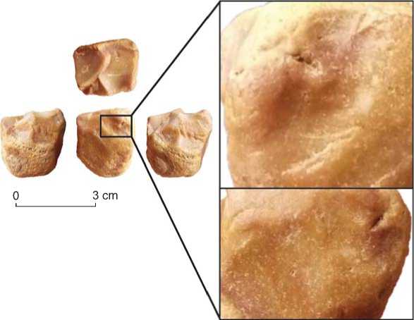
Fig. 4 . Remains indicating the use of anvil, in the form of abrasion and corrosion on the surface of the core.
Knapping methods at the Paleolithic sites of the Neyshabur plain
The studies performed on the Lower and Middle Paleolithic representative cores of the Neyshabur plain indicate the use of four main knapping methods. A unidirectional method was mostly used in unifacial cores, as well as chopper-cores. In this method, the flakes were removed directly with a stone hammer. This method can be considered as one of the most primitive flaking methods in Lower Paleolithic industries (Shea, 2013: 52); a method that has been used extensively alongside other methods in various prehistoric periods. The bipolar method was used with an anvil. In this method, the flaking was conducted in a two-platform manner, in such a way that the flakes were removed by placing the core on an anvil, from two opposite platforms. The parallel method has been identified in at least two blade cores. It was used for obtaining elongated flakes with relatively parallel edges. The centripetal method can be seen in at least 3 pieces of cores (Fig. 5, 5 ). In this method, which was one of the main techniques in knapping discoid cores, the flakes were removed from the outer edges to the central part of the core. This method was performed in both unidirectional and bidirectional manners.
Dispersal patterns of hominins and the role of the northeast of the Iranian Plateau
One of the most important purposes of Paleolithic studies has been to investigate possible patterns of hominin dispersal in the Pleistocene era, especially out of Africa (Bar-Yosef, Belfer-Cohen, 2001: 25). Meanwhile, the role of the Iranian Plateau cannot be ignored. The Iranian Plateau, being located between two water barriers (the Caspian Sea to the north and Persian Gulf to the south), owing to its high environmental potentials and its remarkable geography, could have played a significant role in attracting Paleolithic populations (Nasab, Clark, Turkamandi, 2013: 268). The majority of the research in Iran has focused mostly on Zagros and to some extent on Alborz regions, rather than the northeastern areas.
Excavations in Key Aram cave can be considered the only stratigraphic evidence from northeastern Iran. This cave is located at the eastern end of the Alborz Mountain chain, parallel to the Kopet Dag, at the altitudes where during the Pleistocene its inhabitants were likely to experience conditions of severe cold due to long glacial periods. The low snowline during glacial periods, access to specific types of hunting resources (not necessarily abundant), local raw stone material, and the mountainous nature of the region, which is very similar to Alborz and Zagros, have caused the types of artifacts and the production technique used to produce them to be comparable to the Mousterian of Zagros (McBurney, 1964: 395).
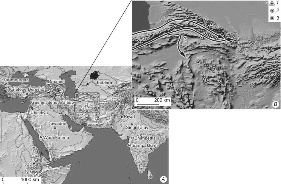
Some researchers have examined the migration corridors of hominins and the patterns of their distribution in the Iranian Plateau (Nasab, Clark, Turkamandi, 2013: 275). Of the three major corridors and dispersal routes, two routes possibly passed through the northeast part of the Iranian Plateau (Fig. 6, B ). This conclusion can
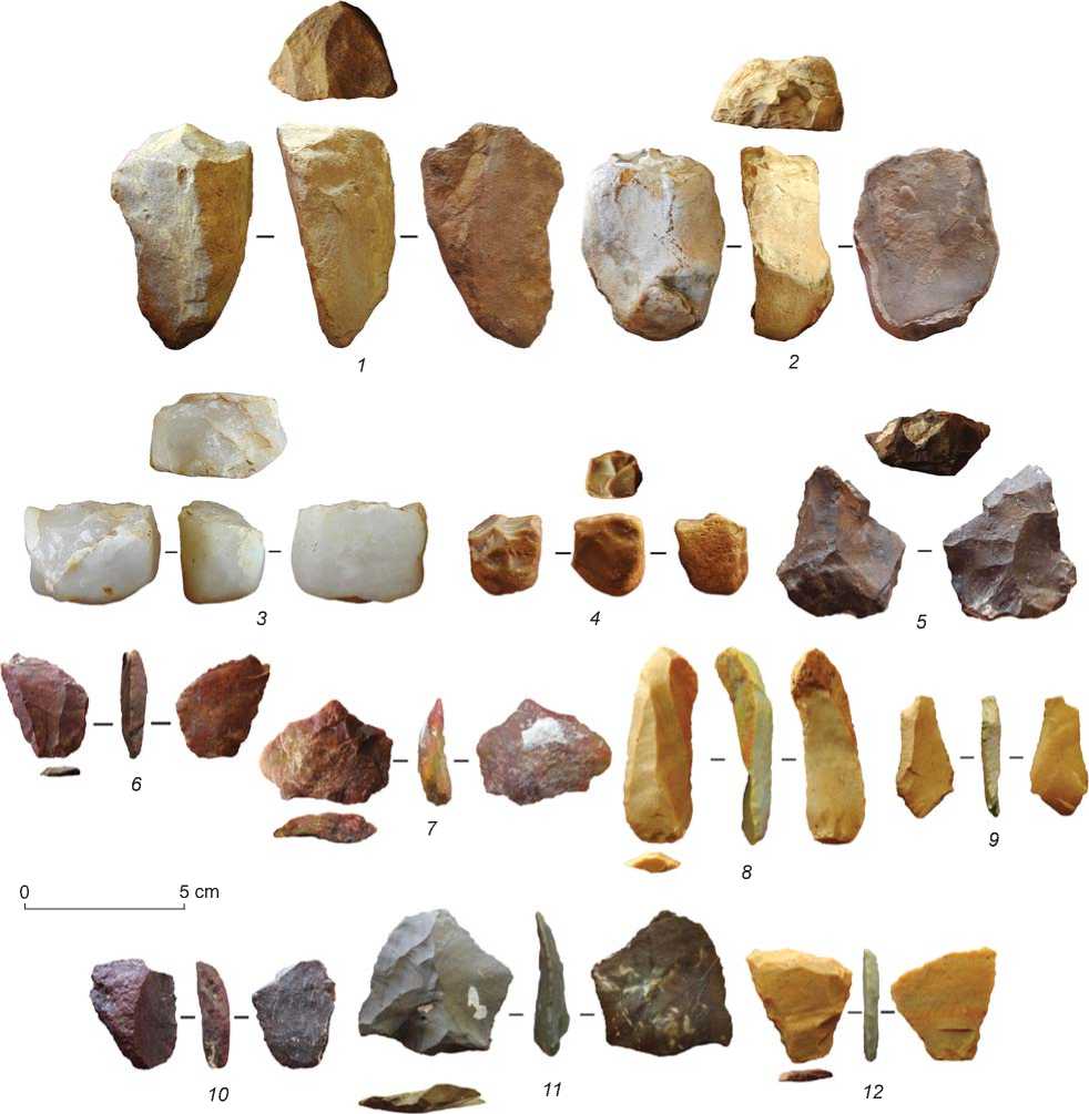
Fig. 5 . Some lithic artifacts found in Paleolithic sites of Neyshabur plain.
1 – chopper-core; 2 – massive scraper; 3 – unifacial core; 4 – anvil-made core; 5 – centripetal core; 6–7 – Levallois flakes; 8 – double-side scraper on Levallois blade; 9 – notch on blade; 10 – side-scraper; 11 – Levallois point with irregular retouch; 12 – déjeté scraper.
be partially supported by the evidence obtained from Kashafrud (Neyshabur plain) and Key Aram Cave. However, the eastern regions of Iran have been neglected in these patterns. Perhaps the most important reason is the particular geographical location of the northeastern and southeastern parts of the country, which may have played a significant role in the distribution of hominins in the more northerly parts of Asia on the one hand, and the southern part of Asia on the other hand.
The first possible route in the northeast of the Iranian Plateau was a corridor that is called “Hezar Masjed– Binalud” by the authors. This corridor encompassed extensive inter-mountain plains, where currently big cities such as Ashkhaneh, Bojnord, Quchan, and finally Mashhad are located. Its northern edge ends at the Hezar Masjed mountain chains, and its southern edge finally leads to the Binalud mountain range and its northern foothills. Its most important (but not the only) water
"Yarimburqazj iBmanisu
Kuldara
'Kalctcpc Dei ■
^0
200 km
5esher^Benot№a^aqo'
B
.Ubeidiya.
foRiwat
Dawadmr
SingDTalav о Wadi Fatima
Bbimbetka tottirampakkam'
■3
1000 km
X ^
А
Fig. 6 . Some of the most important Lower Paleolithic sites in southwest and south of Asia ( A ), and the general pattern of hominins’ dispersal in the east and northeast of the Iranian Plateau ( B ).
1 – Lower Paleolithic; 2 – Middle Paleolithic; 3 – Upper Paleolithic.
source is Atrek River. Although very limited studies have been carried out in the northern parts of the corridor, scattered evidence can be provided from its southern parts, including the Tabarak site in Quchan plain and the open-air site of Kashafrud. Access to abundant water resources, relatively adequate access to raw stone material (river cobbles), and the geographical features of the region, which has acted as a natural corridor, have affected the migration patterns of wildlife (hunting resources) and, consequently, those of the huntergatherer groups.
The second corridor is divided into two possibly smaller corridors, encompassing the southern part of the Binalud Mountains and the Joghatai mountain range. The Jajarm-Esfarayen-Neyshabur plains are located in the northern part of this corridor, and the Sabzevar-Neyshabur plains in its southern part (Fig. 6, B). The western edge of the corridor can be seen along the northern side of the Central Iranian Plateau, where important Paleolithic sites, including Mirak, Chah-e Jam, and Sufiabad, are located. Its eastern edge passes through the Neyshabur plain and extends towards the Mashhad plain. Unlike the Hezar Masjed–Binalud corridor, this territory is relatively low in height and contains significant deserts and playas in its western part, for example in the Jajarm plain and western part of the Sabzevar plain. The presence of an ophiolite belt in this region has provided significant raw stone material, widely used until the post-agrarian period. The most important sites of this corridor can be seen in the Sabzevar and Neyshabur plains, from among which the evidence of the Lower Paleolithic period has only been identified in the Neyshabur plain; and other pieces of evidence are related to the Middle Paleolithic era, including three sites in the Neyshabur plain and one in the Sabzevar plain.
It should be noted that the two corridors have been considered here with regard to the environmental potential of the region, as well as the little evidence obtained. In order to achieve a much clearer picture, and to approve or rule out the existence of these two routes in the past, more purposeful research should be conducted in the future. In the meantime, the role of the eastern Iranian Plateau in these distributions has to be carefully investigated, an issue that has not been addressed so far owing to lack of evidence.
Conclusions
The northeast of the Iranian Plateau in prehistoric times, particularly in the Paleolithic, still remains unknown. To date, in this extensive and climatically diverse region, no referable sites can be mentioned that can be attributed to one of the four Paleolithic periods. Looking at the location of the four open-air sites in the Neyshabur plain and other finds discovered in the northeast of the Iranian Plateau so far, two possible routes can be proposed that may have been influential in the distribution of hominins in the region. The first corridor, called Hezar Masjed–Binalud, includes the Ashkhaneh, Bojnord, Shirvan, Quchan, and Mashhad plains, and the second corridor includes the inter-mountain plains between the Binalud and Joghatai mountain ranges, beginning from Jajarm and Esfarayen plains and eventually ending in Neyshabur and Mashhad plains. Moreover, the southern route of the corridor includes the Sabzevar-Neyshabur plain in the southern part of the corridor. Most of the evidence obtained from these areas suggests the high potential of these two corridors for the attraction and dispersion of hominins, despite the fact that Paleolithic finds are only surface data. However, the role of eastern parts of Iran in tracking these patterns remains questionable. There are many uncertainties regarding this issue that can only be resolved by conducting further purposeful studies in the future.
Acknowledgments
The authors would like to express their gratitude to Dr. Mohammad Hossein Rezaei, who permitted the group to study and survey the region. The authors are also thankful to the members of the survey team.
References First Evidence of Pleistocene Archaeology on the Neyshabur Plain and its Role in Reconstructing the Dispersal of Hominins on the Northeastern Iranian Plateau
- Alperson-Aftil N., Richter D., Goren-Inbar N. 2017 Evaluating the intensity of fire at the Acheulian site of Gesher Benot Ya’aqov - Spatial and thermoluminescence analyses. Plos One, vol. 16: 1-15.
- Ariai A., Thibault C. 1975 Nouvelles précisions a propos de l’outillage Paléolithique ancient sur galets du Khorassan (Iran). Paléorient, vol. 3: 101-108.
- Barfi S., Soroush M.R. 2014 A workshop on the construction of stone artifacts from the Middle Paleolithic Period, Sarbisheh city, Southern Khorasan. In Selected Proceedings of the National Archaeological Conference of Iran, H.H. Zarj Abad, M.H. Ghoreishi (eds.). Chahar: Derakht Publication Inc., pp. 18-29. (In Persian).
- Barfi S., Zafaranlou R., Soroush M.R. 2014 Introducing an open-air site in Qaenat North of Southern Khorasan. In Selected Proceedings of the National Archaeological Conference of Iran, H.H. Zarj Abad, M.H. Ghoreishi (eds.). Chahar: Derakht Publication Inc., pp. 1-12. (In Persian).
- Bar-Yosef O., Belfer-Cohen A. 2001 From Africa to Eurasia - early dispersals. Quaternary International, vol. 75: 19-28.
- Belmaker M., Tchernov E., Condemi S., Bar-Yosef O. 2002 New evidence for hominid presence in the Lower Pleistocene of the Southern Levant. Journal of Human Evolution, vol. 43: 43-56.
- Biglari F., Shidrang S. 2006 The Lower Paleolithic occupation of Iran. Near Eastern Archaeology, vol. 69 (3/4): 160-168.
- Coon C.S. 1951 Cave Explorations in Iran, 1949. Philadelphia: University of Pennsylvania Press.
- Davis R.S., Ranov V.A. 1999 Recent work on the Paleolithic of Central Asia. Evolutionary Anthropology: Issues, News, and Reviews, vol. 8: 186-193.
- Fotohi S., Alinia H., Firozi F., Bakhshipoor J., Rakhshani Z. 2013 The Positioning of areas susceptible of landslide (a case study: the north of Neyshaboor). Journal of Environmental Hazards. Ser. 3, vol. 2 (3): 61-75.
- Jami Al-Ahmadi M. 2008 Review of Paleolithic Studies in Kashfrud River Basin and the Introduction of New Paleolithic Sites: Master’s Thesis. Department of Archaeology, Tehran University. Tehran.
- Lordkipanidze D., Ponce de León M.S., Margvelashvili A., Yoel Rak, Rightmire G.P., Vekua A., Zollikofer C.P.E. 2013 A complete skull from Dmanisi, Georgia, and the evolutionary biology of early Homo. Science, vol. 342: 18-28.
- McBurney C.B.M. 1964 Preliminary report on Stone Age Reconnaissance in NorthEastern Iran. Proceedings of the Prehistoric Society, vol. 30: 382-399.
- Nasab H.V., Clark G.A., Turkamandi S. 2013 Late Pleistocene dispersal corridors across the Iranian plateau: A case study from Mirak, a Middle Paleolithic Site on the Northern edge of the Iranian Central Desert (Dasht-e Kavir). Quaternary International, vol. 300: 267-281.
- Nikzad M., Sedighian H., Ghasemi E. 2015 New evidence of Paleolithic activity from South Khorasan, Eastern Iran. Antiquity, vol. 89 (347). - URL: http://antiquity. ac.uk/projgall/nikzad347
- Ranov V.A., Carbonell E., Rodriguez X.P. 1995 Kuldara: Earliest human occupation in Central Asia in its Afro-Asian context. Current Anthropology, vol. 36 (2): 337-346.
- Rokni J., Hosseinzadeh S.R., Lashkaripour G.R., Valipour S. 2016 Investigation of landslide, landscapes and geomorphological developments in compact plains, case study: Neishabour Plain. Quarterly Journal of Geographical Studies of Arid Areas, vol. 6 (20): 21-38.
- Rose J.I., Petraglia M.D. 2009 Tracking the origin and evolution of human populations in Arabia. In Evolution of Human Populations in Arabia: Paleoenvironments, Prehistory, and Genetics, M.D. Petraglia, J.I. Rose (eds.). Dordrecht: Springer Academic Publishers, pp. 1-12.
- Sadraei A., Anani B. 2018 Kalat-e Shour, Sarayan, evidence of the presence of Pleistocene Population in the Eastern Iranian plateau. L’anthropologie, vol. 122: 722-736.
- Sadraei A., Mehne M.F., Saburi H., Garazhian O., Azar M. 2017 New evidence of Middle Paleolithic period in Sabzevar plain, Northeast of Iran. Archaeology, vol. 5 (1): 1-6.
- Sadraei A., Mehneh M.F., Sheikh M., Anani B., Minaei Z.H. 2019 Kaftar Kouh of Ferdous, new evidence of Paleolithic population in southern Khorasan, Iran. Advances in Anthropology, vol. 9: 111-123.
- Sadraei A., Mehne M.F., Toghraei M., Anani B., Azar M. 2018 The probable Lower Paleolithic evidence from Darongar River, Dargaz, North Khorasan, Iran. Archaeology, vol. 6 (1): 6-11.
- Shea J.J. 2013 Stone Tools in the Paleolithic and Neolithic Near East: A Guide. Cambridge: Cambridge Univ. Press.
- Shipton C., Blinkhorn J., Breeze P.S., Cuthbertson P., Drake N., Groucutt H.S., Jennings R.P., Parton A., Scerri E.M.L., Alsharekh A., Petraglia M.D. 2018 Acheulean technology and landscape use at Dawadmi, Central Arabia. Plos One, vol. 13 (7): 1-36.
- Slimak L., Kuhn S.L., Roche H., Mouralis D., Buitenhuis H., Balkan-Atlı N., Binder D., Kuzucuoglu C., Guillou H. 2008 Kaletepe Deresi 3 (Turkey): Archaeological evidence for early human settlement in Central Anatolia. Journal of Human Evolution, vol. 54: 99-111.
- Vishnyatsky L.B., Lyubin V.P. 1995 Paleolit Turkmenii: Drevneishiye industrii i problema pervonachalnogo zaseleniya. Arkheologichesky almanakh, No. 4: 41-46.
