Genetic description of soil cuts along the horizons of characteristic zones of the territory of Baku-Tbilisi-Ceyhan oil pipeline

Author: Mustafayev Mustafa G., Djebrailova Gyulnara G., Mustafayev Farid M.
Journal: Природные системы и ресурсы @ns-jvolsu
Section: География и геоинформатика
Article in issue: 2 т.7, 2017.
Free access
The majority of the soil cuts in the research on such scale didn’t fall on the zone where BTC oil pipeline passes. On the other hand, a lot of changes occurred in the soils and in a degree of subsoil water mineralization for a long time (secondary salinizatoion of soils, rising of the subsoil water level, increase of their mineralization, change of eco-bio-morphogenediagnostic signs, etc.).
Water-physical properties, mechanical composition, soil porosity
Short address: https://sciup.org/149129605
IDR: 149129605 | UDC: 631.6 | DOI: 10.15688/jvolsu11.2017.2.4
Генетическое описание почвенных разрезов по горизонтам характерных участков, находящихся на территории Баку-Тбилиси-Джейханского нефтепровода
Большая часть разрезов почвы в исследованиях такого масштаба не попадала в зону, где проходит нефтепровод Баку - Тбилиси - Джейхан (БТК). С другой стороны, в почвах и в степени минерализации подземных вод в течение длительного времени произошло много изменений (вторичное засоление почв, повышение уровня подземных вод, повышение их минерализации, изменение эко-биоморфогенедиагностических признаков и др.).
Text of the scientific article Genetic description of soil cuts along the horizons of characteristic zones of the territory of Baku-Tbilisi-Ceyhan oil pipeline
DOI:
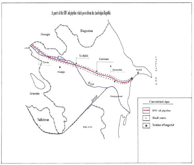
We noted in the first chapter that the BTC (Baku-Tbilisii-Ceyxan) zone, where oil pipeline passes, is divided into 3 parts according to their natural condition. We called those parts “Absheron”, “Shirvan”, and “Ganja-Gazakh”. A length of the pipeline in the Absheron part is
33 km. Its first 6-7 km surrounding is a straight place consisting of hills. After the 7th km the pipeline passes over the hills the height of which rises gradually. A description of two cuts over a plain and hill is enough to characterize soil cover of this part.
AY΄s 0-12cm.
Colour is grey, is shot with brown, consists of sand and cockleshell, unstructural, plant roots dense little, salty, passage is clear.
|
AY΄΄s, m, 10-21cm. |
Colour is grey-yellow stubble, granulometric structure is hardened, structure is clody prismatic schystous, plant roots are observed, little, salinity rises, passage is gradual. Colour gets dark (yellowness rises), granulometric structure is |
|
Bca, s 21-55 cm. |
middle light, structure is clody-prismatic salnistous, plant roots get reduced more, saltness gets increased a little, passage is gradual. Colour is yellow-grey, granulometric structure is middle heavy |
|
Cs, c, s 109-165cm. |
structure is schistous, salty, passage is gradual. Colour is yellow-grey, granulometric composition is middle-light, |
|
CDca, s 165-216cm. |
structure is schistous, salty, passage is gradual soils of the cut are dry along the whole profil |
|
AY 0-18cm |
Colour is grey, is shot with brown granulometric structure is clody-schistous, has plant roots, salinity is little, passage is clear |
|
AYs, ca 18-62cm |
Colour is grey, is shot with yellow-brown, granulometric structure is middle heavy, structure is clody-schistous, has plant roots, salinity gets increased, passage is clear |
|
BCs, ca 62-114cm |
Colour becomes dark (yellowness increases) in comparison with the previous stratum, granulometric structure is middle heavy, structure is clody-schistous plant roots are very little, salinity rises, passage is gradual |
|
Cs, m 114-170cm |
Colour is yellow-grey, granulo-metric structure becomes heavy, structure is clody-schistous, salty, assage is gradual. |
|
CDca, s, cs 170-250cm |
All the indices are as in the previous stratum, small rocks with cockleshell are observed in this stratum. |
|
AYca, v 0-22cm. |
Colour is ordinary-grey, granulometric structure is middle heavy, structure is clody-granular, plant roots are much, straight small eyes are observed (it’s not little) passage is gradual. |
|
ABca, s 22-61cm. |
Colour is brighter in comparison with the upper layer, granulometric structure is middle-heavy, structure is clody-granular, plant roots get reduced a little, salinity is as on upper stratum, passage is gradual. |
|
BCca, cs 61-104 cm |
Colour is beight-grey, shot with yellow, granulometric structure becomes lighter, after 75 cm, structure is clody on upper part, sandy on low part of the horizon, plant roots are very little, salinity gets reduced, passage is clear. |
|
Cca, s 104-156 cm |
Colour is yellowish bright-grey, granulometric structure becomes heavy, structure is clody-schistous, salinity gets increased, passage is clear. |
|
Cca, cs 156-203 cm. |
Colour is yellowish-grey, granulo-metric structure is heavy, structure is clody-schistous, salinity is little in comparison with the previous horizon, passage is clear. Colour is yellow (greyish), gra-nulometric composition becomes lighter, disturbed structure, salinity gets reduced. |
Cut 1 is put between 6-7 km of the BTC oil pipeline, 20-30 m aside the pipeline (at the left of the road going to the Umbaki village). The place, where the pipeline passes, is plain. The right and left parts of the zone (at a 400-500 m distance) are hilly. It is a virgin place consisting of the sparse wild plants. Its soils belong to the grey-brown type.
Cut 3 is put at 25 km of BTC oil pipeline, 20 m on the left, on the high hill. The around area consists of stable wild grass. Soils are dry and belong to the grey-brown type. The relief of the place from which the pipeline passes at 27th km becomes complicated and dangerous for a pipeline. If an earthquake with a high mark happens or it rains very hard, the pipeline becomes worse though safety measures fulfil [1; 2; 3; 4 ]. The hills end the pipeline passes to the plain zone at the 30th km. Soil type gradually changes and passes from grey-brown to a meadow-grey one. Subsoil waters aren’t observed in the depth of
3.0-3.5 m. The arable areas begin in a plain zone. They consist of grain plants (wheat and barley). The unsalted places are covered with nightshade, branchy winter grass, wedge-herb, liquorice, tamarisk. The meadow-grey soils after passing a district center of Hajiqabul continue till 56-60th km of the pipeline. But the grey-meadow soils are found in the sunken places, and grey-brown soils are found on the high hills of this part. A description of the cuts in the zone where meadow-grey type of the soils spread.
Cut 7. This cut has been put at the right of the 47th km, at 22 km aside. It is a virgin zone covered with the natural plants. The soils in the lowest depth within 0-50 cm layer are humid in comporison with the part of “Absheron” of the pipeline. The hilly country ends after 5660 km of the pipeline, that is 10-15 km away from it, the zone passes to the plain. After 70 km of the pipeline a type of the soils turns from meadow-grey into grey-meadow. These types of the soils continue to the border of the district of Yevlakh with Goranboy. A length of this zone from which a pipeline passes is 150 km. We must note that granulometric compositions of the soil which spread in this zone is very heavy and salinity is high enough [5; 6; 7]. Let’s dwell on
AYs 0-26 cm.
AYs, ca 26-57 cm.
Bca, s, m 57-105 cm.
Cca, s, ca 105-162 cm.
CDs, cs, ca > 162 cm.
The colour is grey (is shot with dark), granulometric structure is middle heavy, structure is little clody, cracky, thin plant roots are observed, very salty, passage is clear.
Colour is grey (it is clear in comparison with upper horizon), granulometric composition is heavy, structure is clody-schistous, plant roots are thinner, very salty, passage is gradual.
Colour is bright-grey, (yellowish), ganulometric structure is heavy, structure is clody-schistous, very salty, passage is gradual.
Colour is bright-grey, granulometric composition is middle heavy, thin sandy (strawy colour) layer is noticed at 35 km, structure is clody-schistous, salt is more, but it gets decreased in comparison with the upper layers, passage is gradual.
Colour is bright-grey, granulometric structure is some more light in comporison with the upper layers, structure is clody-schistous, salty.
As, 0-24 cm.
AYs 25-59 cm.
AYs, ca 59-108 cm.
CD``c, cs, ca 165-200 cm.
Surface is pure-white, a colour of the soil becomes dark in 10-15 cm of depth (darkgrey), granulometric composition isn’t heavy (middle), rust spots begin from the upper layer, structure is soft coarse dusty, plant root is rery little, very salty, passage is clear.
Colour is shot with black, rust increases, granulometric structure grows heavier, hard, structure is clody, very salty, wet, one shoranotu root passes into the low layer, passage is gradual.
Colour becomes dark being spot with (blueish-yellow),granulometric composition is heavy,structure is clody, very salty, wet passage is gradual.
Blackness in its colour continues (blueish, dark-grey), rust spots, granu-lometric structure is heavy, structure is clody, very salty, humidity rises, pas-sage is gradual.
AYs – 0-28 cm.
ABcas 28-61 cm.
BCca, s, m. 61-104 cm.
Cca, s 104-149 cm.
Cs, cs 165-202 cm.
Colour is grey, sod layer exist in the part not used under grain, granulometric composition isn’t heavy (growing layer), structure is granular, there are not plant roots, salts aren’t found, passage is clear.
Colour is some more dark in comparison with the upper layer (browness is noticed), granulometric structure is heavy, dense, structure is heap-clody structural, passage is gradual.
Colour becomes bright grad-ually, yellow colour is noticed clearly, granulometric structure is heavy, structure is clody-structural, plant roots are little, sometimes salt peep-holes are observed, passage is gradual.
Colour is grayish-strawy, granulo-metric structure is becomes light some more, structure is clody-thin struc-tural, sometimes salt peepholes are observed, passage gradual.
Colour is strawy-grey, granulometric composition gets light some more, structure is small clody-thin schistous, salinity is little.
the description of some cuts which characterize this zone.
Cut 11. This cut is put at 85 km, on the right of the pipeline at a distance of 25 m. It is a useless saline area. Its vegetation consists of different saline grass-onion, salt-marsh and others. The soil type is grey-meadow.
AY -0-29 cm.
AYca, s 29-62cm.
ABca, s 62-108 cm
Cca, s 108-159 cm.
Cc a, cs, s.
Colour is grey, crusty, there are clefts at 10-15 cm of the depth, granu-lometric structure is middle heavy, structure is heap-clody-prizmatic (lo-wer than 20 cm), roots are much, unsalty, passage is clear.
Colour is shot with grey-brown, granulometric structure is heavy, it is tightened, structure is clody-prizmatic, roots are little, there is no salt, passage is gradual.
Colour is grey-brown,yellowish, gra-nulometric structure is mean heavy, hard, structure is clody-prizmatike-schistous, thin salt peepholes are observed, passage is gradual.
Colour is grey-strawy, grey colour isn’t felt, granulometric structure is heavy, hard, structure is clody-thin schistous, thin salt peep-holes are observed.
The depth below 159 cm likes the former layer.
AY’a, z 0-31cm
AY’’a, ca 31-63cm.
Bca 63-105cm
Cza 105-156cm.
Cza 105-156cm.
Colour is dark-brown, granulometric composition is middle-light, structure is heap-boll-shaped-granular, soft, is rich with the plant roots, salts are observed, dry, passage is clear.
Colour is ordinary-brown, granulo-metric structure is light, structure is coarse heap-granular, some more ligh-tening, roots are more, thin white car-bonate spots are observed, passage is gradual.
Colour is bright-brown, greyness is felt, granulometric structure is light-average, structure is heap-like-clody-like, hard thin roots are observed, white carbonate points get increased, passage is gradual.
Colour is grey-brown (strawy), gra-nulometric composition is middle-lig-ht, structure is clody-prizmaness, schi-stous, hard dense carbonate peep-holes are observed, passage is gradual.
Colour is grey-brown (strawy) granulometric composition is mean light, structure is clodish-prizmatic-schistous, hard, dense carbonatic peep-holes are observed, passage is gradual.
Colour is grey (strawy), granulometric composition is light-mean, structure is non-clear, carbonate are as in the previous layer.
Cca 156-203cm
AY’a,z. 0-32cm.
AYa’’’m 32-61cm.
Bca, m. 61-103cm
Bcla 103-149cm
Colour is brown, granulometric com-position is mean-light, structure is heapy-nut-like-granular, soft, plant-roots are much salt, isn’t observation, dry, passage is clear.
Colour is brown-greyish, granulo-metric composition is mean, structure is heapy-granular, dense, roots get reduced some more in comparison with upper layer, white carbonatic peep-holes are observed, passage is gradual.
Colour becomes light, grayish gets increased, granulometric structure is light, structure is heapy-clody-like, hard, roots are very thin, carbonat peep-holes get increased, passage is gradual. Colour is grey-strawy, granulometric composition is mean light, structure is clody-little-przma-like-schistous, hard, carbonat peep-holes are much, passage is gradual.
Colour is grey-strawy, granulometric composition is light-mean, structure is non-clear, carbonate is as in the previous layer.
Cla 149-195cm
The interesting cuts are K-30 and K-31 according to the view of the zone surface in “Shirvan” part of the pipeline. The cuts are put at 179 and 184 km of the pipeline. K-30 is situated in Alpout and K-31 is near the Garadagli village of Ujar. This part of the pipeline loses its vegetation. Here salt-tolerant saline grass are sometimes found (black shranotu, succulent shoranga). The soil type is grey-meadow. Subsoil water at 3.03 m of depth of the cut K-30 is observed.
Cut 32 is put at 193 km of the pipeline on the well-developed, grain area. Meliorative state of the soils of this saline area was improved by using under paddy in 70 years of the last century. Though the meliorative state of around areas is good, they aren’t used rationally. The soils belong to the grey-meadow type. Subsoil water is 2.36 m. From the 193rd km till the Kur river a great deal of the soils of the zones where the pipeline passes expose to salinity to an average and high degree. Three soil cuts are put here to characterize the spread soils in the Yevlakh district.
AYvz 0-24cm.
AYca 24-27cm.
Bla, s 47-88cm.
BCca, m 88-132cm.
Cca 132-178cm.
Colour is bright-brown, granulometric composition is mean light, structure is heap-nut-shaped-granular, isn’t hard, soddy, is rich with plant roots, there isn’t salt, passage is clear.
Colour gets dark some more (greyish), granulometric composition is mean-light, structure is nut-shaped-granular, dense, roots are much, white carbonatic peep-holes are observed, passage is gradual.
Colour is bright, greyness gets inc-reased, granulometric composition is mean-light, structure is heapy-clody, hard, roots get thin, carbonate rises, other coloured salts are observed, pas-sage is gradual.
Colour gets bright (grey-brown), gra-nulometric composition is light, struc-ture is clody-like-little-prizmalike, hard, a total quantity of salts gets incre-ased, (peep-holes), passage is gradual.
Colour is grey-strawy, granulometric composition is mean-light, structure is non-clear, salts (peep-holes) get incre-ased, passage is not clear.
Colour is grey-strawy (yellowish rises), granulometric composition is mean, structure isn’t clear.
KDca, s >178cm.
pass into meadow-grey, but after 10-15 km pass into the grey-brown type. The different subtypes of the grey-brown soils continue to the border of Georgian Republic. After entering the Goranboy district at 10-15 km a view of the zone, where the pipeline passes differs sharply from the former two parts of “Absheron” and “Shirvan” (the verdure increases around, the areas are used under sowing). The verdure only gets reduced from the part where the pipeline crosses the Kur river and enters the east of the Garayazi plain and the west of the Seyranchol plain till the border of the Georgia Republic. The soils salinized to an average degree are found at the first 10-15 km of the Ganja-Gazakh massif of the pipeline. At the 245th km of the pipeline K-43 is found, and K-45 is found at 255 km. The soils which consist of stone-sand with a different size exsist in some places of this part. They are observed in the deposits of the Ganjachay, Shamkirchay, Tovuzchay, Zayamchay, Akstaphachay and other little rivers from which the pipeline passes. Let’s dwell on some cuts which characterize the soils of the zone passing from the Ganja-Gazakh massif. K-109 is put at 35 km of the well-developed grain area. The soil type is greybrown. The first two layers of the cut are dry, humidity gradually increases in the former layers, but the whole field doesn’t reach the fertile capacity. Cut 114 is put in the area under normaldeveloping grain in 395 km of the pipeline, 500 m apart from the pipeline. The soils of the cut belong to the grey-brown type.
After 0-50 cm of the cut humidity gradually increases while going into the low horizonts, but the whole field doesn’t reach the fertile capacity. Cut 126 is put in the pasture, 600 m apart from the pipeline in the Garayazi plain of the Azerbaijan part (430 km.). The cut is dry along the whole profile.
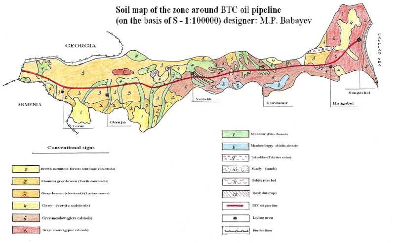
The soils in the zone along the BTC oil pipeline consist of describing genetic horizons. The pipeline passes from stony (river deposits) and boggy soils. They are mainly observed near the river deposits.
Some physical and chemical parameters of the soils in the characteristic places of the zone where BTC oil pipeline passes.The following physical and chemical indices of the soils are applied in the characteristic places of the zone where BTC oil pipeline passes: voluminous and special masses; mechanical structure; humus quantity; soil solution reaction (pH); absorbed bases and a percentage quantity of natrium ion which catch from their totality; saltness and its composition [7; 8; 9].
The soil samples taken from 18 cuts have been used in order to get information about a volume and special masses in the zone along the pipelinee. The voluminous and special masses have been determined for 0-50 and 0-100 cm horizons of one-metre depth of the soil. One of these cuts (cut-1) is in the part that is called “Absheron” and it characterizes voluminous and special mass of the soil in 31 km of its length. In 0-50 cm layer of the first cut a voluminous mass is 1.32 g/cm3, in 0-100 cm layer it is 1.29 g/cm, a special mass is 2.64 and 2.60 g/cm3. A voluminous and special masses of the soils in the second part which we call “Shirvan” are 11, 19, 23, 25, 29, 33, 38, 150 and 154. The voluminous masses of the soils in this part of the zone are 1.28 g/cm3-1.46 g/cm3 in 0-50cm-layer, 1.16 g/cm2-1.45 g/cm3 in 50-100 cm layer, special masses are 2.65 g/cm3-2.79 g/cm3 in 050 cm layer. When the parameters are compared, it is known that the numbers which express the voluminous and special masses of the spreading soils along a zone are changeable, they aren’t high in some places but very high in other places. The high indices are observed in the plain places of Shirvan, but not high parameters are situated at foothill and near it. A volume and special masses of the soils spreaded in the 3rd part of “Ganja-Gazakh” massif of the pipeline are characterized by the indices of 103, 109, 114, 120, 125 and 130 numbered cuts. The voluminous masses change by 1.24 g/ cm3 and 1.35 g/cm3, but special masses change by 2.54 g/cm3 and 2.65 g/cm3 in both of 0-50 and 0-100 cm depth of this part of the zone. While comparing the indices of each 3 part of the zone where a pipeline passes it is not difficult to notice that the numbers which express voluminous and special masses in the first and second parts are near one an other and aren’t high, but it is high in the second part. The indices which give an opportunity to determine granulometric structure of soils, while increasing values of these parameters a granulometric composition of the soils must grow heavier.
Conclusions
-
1. Volume and special mass of the soil: accordingly 1.29-1.32 g/cm3 and 2.60-2.64 g/cm3, in the Absheron part of the pipeline; 1.36-1.45 g/ cm3and 2.67-2.79 g/cm3 in the Shrivan part; 1.241.35 g/cm3 and 2.54-2.65 g/cm3 in the Ganja-Gazakh massif part.
-
2. A quantity of physical clay < 0.01 mm and still (0.001) in a granulometric structure of the soils; 37.6-60.5% and 15.3-28.6% in the “Absheron” part; 65.0-90.6% and 33.2-40.3% in the “Shrivan” part; 33.0-50.5% and 15.3-22.6% in the “Ganja-Gazakh” massif part. It is clear from the figures that the soils of Abseron, Shrivan and Ganja-Gazakh possess middle, heavy and light granulometric structure. pH parameter marks form pH=7.5-7.8; pH=7.6-8.4 and pH=7.2-7.5 in the Absheron, Shrivan and Ganja-Gazakh massives of the pipeline.
-
3. Salinity of the soil in the Absheron part of the pipeline changes by 1.05%-3.16%, in the Shirvan part by 0.14%-4.03% and by 0.06% -0.36% in the Ganja-Gazakh part. The subsoil waters are in the depth of 4.0-20 m from surface in the Absheron and Ganja-Gazakh massives of pipeline, 2.6-3.15m in the Shirvan part. Their mineralization degree forms >10g/l, 2.0-61.6g/l and 0.5-2.5g/l in Absheron, Shirvan and Ganja-Gazakh of the pipeline. The least quantity of the salts which will be able to create a corrosion danger for the oil pipelines may be 1.0-1.5%, but mineralization of the subsoil waters may be 16-20g/l.
-
4. A part of the oil pipeline more than 250 km passes from the places where spread soils salinized to a different degree. It will be good to
be fulfilled meliorative measures in the part of which salinized soils spread (irrigative and collector-drainage net would be stored to a working state and would be fulfilled meliorative measures in accordance with soil salinity). Such measures lengthen both exploitation period of the pipeline and high and constant product would be got from agricultural plants grown in these soils.
References Genetic description of soil cuts along the horizons of characteristic zones of the territory of Baku-Tbilisi-Ceyhan oil pipeline
- Aslanov H.G. Melioration soil science. Chashi oglu. Baku, 1999, p. 346.
- Jafarov Kh.F., Hashimov A.S. Natural condition of the Shirvan plain, character of the experiment-research areas. Azerb. agrar. elmi jour. Baku, 2004, no. 1-3, pp. 282-289.
- Babaev M.P., Jafarova Ch., Hasanov V.H. Contemporary classification of Azerbaijan soils. Baku, 2006. 359 p.
- Azizov G.Z. Water-Salt balance improving of soil-graunds in the Kur-Araz Lowland and scientific analysis of its consequences. Baku, 2006. 258 p.
- Mammadov G.Sh. Azerbaijan soil resources. Baku, 2000.131 p.
- Mammadova S.Z.Soil resources and improvement of Lenkoran soils. Baku, 2003.114 p.
- Volobyev V.R. Quantitave criterian of the value of salty regine of irrigative and meliorated lands. Baku, Azerb. SSR., 1967. 11 p.
- Kovda V.A. Study bases about soils. Moscow, Nauka Publ., 1973. 467 p.
- Mustafaev M.G. Condition of the investigation of saline soils in the Kur-Araz Lowland. Problems of the irrigative land melioration: water-provision and effience use. Reports of the Republic scientific-practical conference (14-15 Sept.). Shimkent, 2006, pp. 136-138.
