Geomorphology and quaternary sediments at archaeological sites near Anzhevka, Krasnoyarsk territory

Author: Zolnikov I.D., Vybornov A.V., Slavinsky V.S., Tsybankov A.A., Kartoziya A.A., Grachev I.A.
Journal: Archaeology, Ethnology & Anthropology of Eurasia @journal-aeae-en
Section: Paleoenvironment, the stone age
Article in issue: 1 т.45, 2017.
Free access
Short address: https://sciup.org/145145293
IDR: 145145293 | DOI: 10.17746/1563-0110.2017.45.1.015-024
Text of the article Geomorphology and quaternary sediments at archaeological sites near Anzhevka, Krasnoyarsk territory
Archaeological studies in Eastern Siberia have long focused on several regions with high concentrations of archaeological sites, such as the Minusinsk Basin, the Yenisei and Angara drainages, and the Lake Baikal area. These are large riverine and lacustrine regions where human subsistence activities were especially intense. Of special interest are adjacent peripheral zones, with tributaries of major rivers and lakes, and watersheds such as mountain ranges and their offshoots. The term “peripheral” in this context is related to the intensity of archaeological studies, rather than to actual historical importance. Human occupation of such zones was often affected by specific factors that may be relevant to understanding the relative chronology and cultural history in this macroregion.
The Kansk-Rybinsk Basin represents one such region on the archaeological map of Eastern Siberia and North Asia in general. Hydrologically and orographically, the basin is associated with the Angara, Yenisei, and Baikal drainages. Archaeological studies have been conducted here since the early 20th century. Investigations carried out by the Joint Archeological Expedition of Irkutsk State University (N.A. Saveliev, A.G. Generalov, and others) constitute an important component of the research. The expedition discovered over 100 archaeological sites spanning the period from the Paleolithic to the Middle Ages. Stationary excavations conducted at several sites made it possible to establish cultural and chronological periodization for specific sites, and for the whole region. Main publications were focused on the Late Paleolithic, Mesolithic, Neolithic, and the Bronze Age. Special attention was paid by the Irkutsk scholars to multidisciplinary examination of the sites, including geomorphological analysis and the study of Quaternary sediments. This approach can be very helpful for understanding the distribution of archaeological materials over a large area under complex and heterogeneous conditions.
A.G. Generalov proposed merging all archaeological sites on the right bank of the Kan River, from the village of Anzhevka to Strizhovaya Gora (5–6 km), into a single geo-archaeological experimental area (2000: 15–16). In 2015, the archaeological team from the Institute of Archaeology and Ethnography SB RAS excavated several sites in this area: on the right bank of the Kan River, southeast of Kansk, within administrative boundaries of the Ilansky Municipal District of the Krasnoyarsk Territory (Vybornov, Grachev, Zolnikov et al., 2015; Vybornov, Slavinsky, Tsybankov et al., 2015). According to records, the sites are currently designated as Nefteprovod-2 (NP-2), Nefteprovod-1 (NP-1), and Ryabchikov Klyuch-1 (RK-1). They were discovered and investigated in 1972 by the Irkutsk State University Expedition led by N.A. Saveliev. In 1989, they were examined by L.Y. Bleynis from Krasnoyarsk. In 2011–2015, the team from Siberian Federal University (Krasnoyarsk) continued the study under the supervision of E.V. Knyazeva and P.V. Mandryka. The sites were named in various ways: Smolenka, Novosmolenka, and Nefteprovod, with various numerical designations. In 2015, it was proposed that they be included into the Anzhevka complex (the Anzhevka village is now abandoned). Assemblages and isolated finds span the period from the Paleolithic to recent centuries. Archaeological materials at the sites occur in a complex geomorphological context. The description and interpretation of the topography and Quaternary deposits will enrich the geological information relating to the middle stretch of the Kan River.
Geomorphology of the region
According to the state geological mapping database (Geologicheskaya karta…, 1968, 1978; Gosudarstvennaya geologicheskaya karta…, 2009), the region under study lies at the northeastern margin of the Antsir-Beloyar anticline located at the junction of the geological structures of the folded zone of the Yenisei Range and the southwestern periphery of the Siberian platform. The formation of Quaternary deposits in the region was affected by geological structure and neotectonics.
A fragment of the geological map at a scale of 1 : 200 000 clearly shows a band of the Kan River valley up to 10 km wide, inversely overlying the Antsir-Beloyar anticline (Fig. 1, 1 ). To the northeast, in the zone of Jurassic sediments (Fig. 1, 4 ), the Kan anticline is traceable, extending from the northwest to the southeast and composed of Devonian sediments (Fig. 1, 2 ). A diagonal fault up to 35 km long runs along the southern margin of the anticline (Fig. 1, 3 ). Along this fault, the
Devonian rocks disrupted the Jurassic mass, causing a 300–3000 m vertical displacement. Since the Cretaceous-Paleogene periods were characterized by tectonic quiescence accompanied by the formation of weathering crust, post-Jurassic deformations can definitely be attributed to the period of Alpine folding and dated to the Cenozoic, primarily NeogeneQuaternary chronostratigraphic interval (Tabatsky, 1982; Tsykin, 2011).
During the Quaternary, the right wall of the Kan valley was subjected to irregular block-differentiated vertical movements associated with neotectonic uplift of the Kan anticline. This caused the formation of heterogeneous linearly-alternating local compression and tension structures situated diagonally (northwest to southeast) and mirrored by the terrain. The Mokhovaya ridge represents the most eminent morphological structure. It is located 4 km north of the study area, and is within the boundaries of the Kan anticline; a neotectonic bench 250 m high delimits its southwestern margin. As topographic maps and high resolution satellite show, several spatially adjacent geomorphological benches smaller in height and length run from the ridge to the right bank of the Kan River.
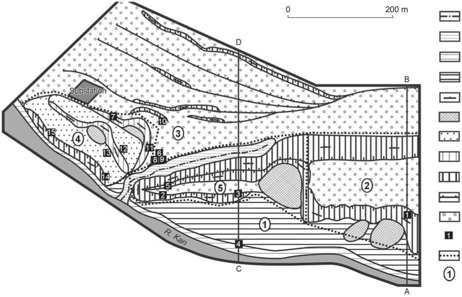
According to the geomorphological map (Geologicheskaya karta…, 1968), the region is characterized by two categories of relief: erosive-accumulative and structural-denudational. The first is represented by the southern portion of the region that is occupied by the valley-terrace complex of the Kan River. The second occupies the right wall of the valley, raised and divided into neotectonic blocks varying in elevation. Five segments, differing in their geological and geomorphological structure, have been recorded at the Anzhevka archaeological complex and the contiguous area (Fig. 2).
Segment 1 is alluvial. It includes surfaces of the floodplain and of the first fluvial terrace of the Kan River. This segment extends as a narrow (up to 100 m wide) strip along the southern and southwestern margins of the study area. The floodplain and fluvial terraces are rock-defended. Bedrocks of the preQuaternary basement are exposed in several places on the bank and bottom of the Kan River. Alluvial surfaces date to the Holocene. Thin subaerial cover (several tens of centimeters thick) envelops floodplain sediments of the first terrace.
The rest of the study area belongs to the category of structural-denudational relief, and consists of four
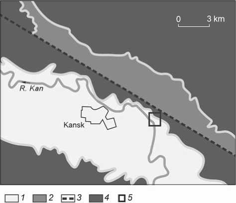
Fig. 1 . Geological structure of the region on a fragment of geological map (after (Geologicheskaya karta…, 1968)).
1 – River Kan valley composed of Quaternary deposits and located on the Antsir-Beloyar anticline; 2 – Kan anticline composed of Devonian sediments; 3 – fault; 4 – Jurassic sediments; 5 – study region.
geomorphological segments differing in landform features and in terms of geological history in the Late Pleistocene and Holocene.
Segment 2 is a flat-topped ridge. It occupies the eastern portion of the region. The ridge is approximately 3 km long; however, the study area covers a fragment that is just 220 m long (Fig. 2). The long axis has a sublatitudinal orientation. The geomorphological profile along A–B line (Fig. 3, 1 ), obtained by tachometric survey, illustrates the shape of the flat-topped ridge in cross-section. The subhorizontal plain surface of the ridge is approximately 120 m wide; the hade of the southern bench is 30° and that of the northern bench, about 20°. The elevation of the surface above the level of the Kan River is 41 m. Multiple landslides are visible on the southern bench. Some of them overlay each other, which points to repeated movements of loose materials down the slope. This landform is a miniature copy of Mount Mokhovaya. This is a neotectonic horst driven out of the bedrock basement of the first fluvial terrace, and raised above the terrace platform to an elevation of over 20 m. The northern, western, and southern slopes of the flat-topped ridge are represented by neotectonic benches, partially smoothed by slope processes and bearing materials of later landslides.
а
b
c
d
e
f
g
h
k
l
m
n
Fig. 2. Geomorphological scheme of the study region.
a – stream; b – stream valley; c – floodplain; d – first fluvial terrace; e – exposure of slopes; f – small landslide bodies; g – platforms of landslide blocks; h – rupture planes of landslide blocks; i – tectonic benches; j – low-amplitude tectonic benches; k – surface of the gently undulating plain; l – test-pits and sections: 1 – control section, 2–5 – Ryabchikov Klyuch-1 (No. 1–4), 6–11 – Nefteprovod-1 (No. 1–6), 12–15 – Nefteprovod-2 (No. 1–4); m – boundaries of the geomorphological segments; n – numbers of the segments.
Segment 3 is a gently undulating plain. This segment apparently belongs to the watershed surface formed by subaerial cover. The surface is subhorizontal; in the southeastern fringe only, it gently dips toward the thalweg of the Bezymyanny stream, which delimits it. Geomorphological profile along C–D line (Fig. 3, 2), obtained by tachometric survey, shows small ridges complicating the watershed’s surface pattern. As can be clearly seen in the right part of the drawing, these small ridges actually represent a series of step-like surfaces with subhorizontal platforms and rather steep and low benches: three of them slope to the north, and one to the south. The southern bench is 8 m high. It forms a natural geomorphological boundary between segment 3 and the Anzhevka archaeological complex in general. The inside of the watershed is a graben composed of a series of blocks descending stepwise toward the fault surfaces in the south-to-north direction (C–D profile shows three such blocks). The graben’s axis and the faults are oriented sublatitudinally in the eastern part of the region, and diagonally (northwest to southeast) in its western part (Fig. 2).
Segment 4 is a ridged-landslide. In the southwestern part of the study region, the watershed segment adjoins asymmetric ridges formed by asequential landslides varying in size (Fig. 2). All back edges and margins of the landslides are parallel, and oriented diagonally from the northwest to the southeast. Such an orientation parallels neotectonic macrostructures, in particular, a neotectonic bench (250 m high) of the Mokhovaya ridge, and faults on the watershed surface of segment 3. Northeastern slopes are milder and wider. They represent fragments of the watershed’s surface declined and raised on shorter and steeper southwestern slopes, where landslide materials have been mixed. Three large landslides are complicated by smaller ones. In general, the segment represents a series of landslide bodies varying in size and moved from the southern margin of segment 3 (watershed plain).
Segment 5 is sharp-crested dissected. In the central part of the study region, segments 1–4 join, and thus form a zone characterized by a complex geological and geomorphological structure. This zone comprises two adjacent sharp-crested ridges stretching sublatitudinally: northern and southern (Fig. 2). The southern margin of the dissected segment is contoured by a bench descending under the platform of the first fluvial terrace of the Kan River; from the north, it is edged with a thalweg of the stream (Fig. 3, 2 ). The northern ridge extends from the northern bench of the horst and inclines to the west. Its southern slope bears scars of asequential landslides. The southern end of the ridge changes its orientation (20° southward) and joins the southern ridge inclined to the east. The latter forms a scrap with steep slopes on the west, and “sinks” in the platform of the first fluvial terrace of the Kan River on the east. In terms of the kinematics of neotectonic block movements, the ridges represent landslide plates removed from the western margin of the horst (segment 2) and separated from it by a dip complicated by a landslide.
The analysis has revealed the principal geomorphological features of the region. The scheme (Fig. 2) shows areas of subaerial deposits and its fragments, separated from one another by neotectonic shifts and landslides (surfaces of gently undulating plain on neotectonic blocks and platforms of landslide blocks). Those areas include old ground surfaces and underlying stratigraphic sequences. There are neotectonic benches, rupture planes of landslide blocks, and low-amplitude neotectonic benches, which dissect stratified deposits including culture-bearing horizons.
Quaternary sediments
Examination of test-pits and geological sections made it possible to reveal a generalized stratigraphic sequence, to construct a correlation scheme of sections, and to combine a composite stratigraphic column (Fig. 4). In the control profile (locus 1 in Fig. 2) on the southern slope of a gentle ridge, the structure of horst was exposed. Stratigraphic sequence comprising three units of sediments overlying the Paleozoic basement were recorded there (from bottom to top).
Unit 1, pre-Quaternary sediments:
Stratum 1. Black humus loam with a layer of lumpy, silty sand 0.2 m thick. The stratum is 1.8 m thick. Genesis: pre-Quaternary paleosol.
Stratum 2. Light gray silty sand forming parallel layers and including humus material from the underlying stratum. A fine-lumped parting is present. The stratum is 0.6 m thick. Genesis: weathering crust redeposited by slope-wash processes.
Unit 2, alluvial sediments:
Stratum 3. Gray sandy gravel-shingle beds interlayered with coarse-grained sand. The cleavage is crude and medium oblique. The stratum is 3.6 m thick. Genesis: riverbed facies of alluvium.
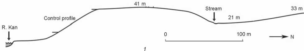
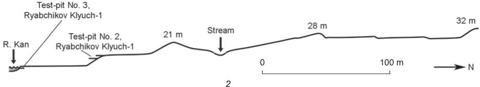
Fig. 3. Geomorphological profiles along A–B ( 1 ) and C–D ( 2 ) lines in Fig. 2 (elevation above the Kan River is indicated).
Stratum 4. Light, yellowish-gray medium- and coarse-grained sands forming subhorizontal and parallel thin beds. The cleavage is fine and small. Sand grains diminish in size in the upper portion of the stratum. The stratum is 2.5 m thick. Genesis: floodplain facies of alluvium.
Unit 3, subaerial:
Stratum 5. Light gray straw-tinted carbonized silty sand. The stratum is 2.8 m thick. Genesis: subaerial loess-like cover.
In the control profile, the principal sequence of sediments was traced. Then the structure of each
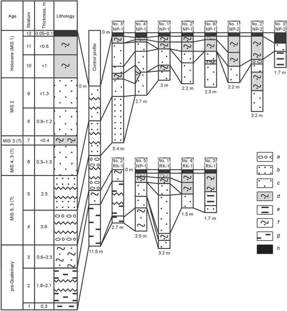
Fig. 4. Correlation between single sections and the composite stratigraphic column.
a – alternation of gravel-shingle and sand; b – washed silty sand; c – unstratified eolian silty sand; d – unstratified sandy loam; e – stratified loams and clays of the floodplain alluvium; f – weathering crust redeposited by slope-wash processes; g – humus loam; h – modern soil. RK – Ryabchikov Klyuch; NP – Nefteprovod.
stratigraphic unit was examined in more detail in other sections (Fig. 4). We will now describe the composite section bottom-to-top according to the units of the principal sequence, with additional observations relating to the most representative exposures.
Fragments of Paleozoic-Mesozoic bedrock of the basement, represented by light gray conglomerates, mixtites, sandstones, aleurolites, etc., are exposed not only in the basement of the flat-topped ridge (near locus 1 in Fig. 2), but also in the lower part of the coastal cliff delineating landslide bodies (near locus 15 in Fig. 2), and also on the southern slope of the sharp-crested ridge (near locus 3 in Fig. 2).
In riverine blocks dissected by neotectonics, preQuaternary (possibly Neogene) loose sediments mark the boundary between the Paleozoic basement and the cumulative cover of Quaternary alluvium. In the control section, the thickness of these sediments totals 2.4 m, including paleosol (1.8 m) and slopewash silty sand (0.6 m). The elevation of the sediments varies from 22.1 m to 24.5 m above the river level. In test-pit No. 2 RK-1 (locus 3 in Fig. 2) at an elevation of 9.5 m above the water’s edge, they are 2.7 m thick (paleosol, 2.4 m; slope-wash silty sand, 0.3 m). In test-pit No. 5 NP-1 (locus 10 in Fig. 2), the visible thickness of slope-wash silty sand underlying the subaerial cover is up to 1 m (paleosol was not exposed).
The uppermost portion of the Quaternary unit is occupied by the alluvial member, which will not be described in detail here. It should be noted, however, that in the study area that includes archaeological excavations, alluvial sediments, represented by thin parallel subhorizontal beds of light gray, medium-grained sand of the floodplain facies (visible thickness, up to 2 m), were discovered in test-pit No. 3 NP-1 (locus 8 in Fig. 2). Because no alluvium was found between the pre-Quaternary deposits and the subaerial complex in the more northerly test-pit No. 5 NP-1, the back edge of the alluvial bed must pass along the southern fringe of geomorphological segment 3. This boundary is apparently represented by a gentle dropping of the southeastern margin of the plain watershed-surface and by the sharp contrast with ridged-landslide segment 4. Shifting of the landslide plates of segment 4, composed of subaerial loam and sand, along the gravel and pebble alluvium seems to be the most probable. North of the back edge of the alluvial bed, landslides are absent; instead, fault and subsidence deformations of geomorphological segment 3 (graben) can be observed. Judging by the height of the Paleozoic basement and the alluvial deposits relative to those in the floodplain and on the first terrace, the vertical uplift of the blocks is estimated at 20 m for the horst, and at 10 m for the sharp-crested ridges. Because the alluvial deposits are above the river level, the age of the uplifts is considered to be post-sedimentational.
Of special relevance to archaeological studies is the structure of the upper sequence, i.e., of the subaerial cover, because it contains culture-bearing horizons. The profiles reveal some facies variation, and occasional absence of certain layers owing to local slope-wash erosion and, more often, to eolian deflation. We will now describe the subaerial member from bottom to top.
Stratum 1. Gray straw-tinted silty sand, unstratified, carbonized, with veins of oxide iron. The stratum is 0.3–1.3 m thick. Genesis: loess-like eolian sediments.
Stratum 2. Dark gray sandy loam with a low content of humus. The stratum is 0–0.4 m thick (wedging out in some places). Genesis: paleosol. This stratum contains Upper Paleolithic artifacts.
Stratum 3. Light straw-colored brownish silty sand, unstratified, carbonized, with veins of oxide iron. The stratum is 0.8–1.2 m thick. Genesis: loesslike eolian sediments.
Stratum 4. Light gray fine- and medium-grained unstratified sands. The stratum is 0–1.3 m thick. The stratum is traceable on the northern slope of the stream’s valley. Genesis: eolian sediments.
In test-pit No. 4 NP-2 (locus 15 in Fig. 2), a bed of gravel and pebbles 3–5 cm thick can be traced at this level. Solifluction loam, comprising gravel and pebbles 20–30 cm thick, overlies this bed. These units mark the descent of the landslide plate up to the moment when its frontal part collapsed into the Kan river and was eroded by water. This local erosion and solifluction horizon has not been included in the composite section because it mirrors a local event relevant to one of the landslides of geomorphological segment 4.
Stratum 5. Brownish-gray to brown sandy loam with reticulate texture. The stratum is 0–1.0 m thick. Genesis: paleosol (illuvial carbonate horizon with deflated eluvial and humus horizons). This stratum contains artifacts of the Neolithic–Bronze Age.
Stratum 6. Humus sandy loam, varying in color from gray to dark gray. The stratum is 0–0.8 m thick. Genesis: paleosol. This stratum contains artifacts of the Iron Age and the medieval period.
Stratum 7. Modern soil. The stratum is 0.05– 0.10 m thick.
Correlation of the horizons recorded in the testpits located in various geomorphological segments made it possible to construct a composite geological section in stratigraphic order (from bottom to top) (Fig. 4).
Paleozoic-Mesozoic bedrock of the basement represented by light gray conglomerates.
Stratum 1. Dark vinous humus loam with grit, gravel, and sand from the bedrock basement. The stratum is 0.3 m thick.
Stratum 2. Black humus unstratified loam with numerous charcoal inclusions. The stratum is 1.8–2.1 m thick. Genesis: pre-Quaternary horizon of paleosols.
Stratum 3. Light gray lumpy silty sands forming parallel horizons and including material from the underlying layer. The stratum is 2.3 m thick. Genesis: weathering crust redeposited by slope-wash processes.
Stratum 4. Gravel-shingle bed with sand, large-and medium-crossbedded. The stratum is 3.6 m thick. Genesis: riverbed facies of alluvium.
Stratum 5. Gray sands, medium- and coarsegrained in the lower part, and fine-grained in the upper part; medium parallel-bedded. The stratum is 2.5 m thick. Genesis: floodplain facies of alluvium.
Stratum 6. Gray straw-tinted silty sands, unstratified, carbonized, with veins of oxide iron. The stratum is 0.3–1.3 m thick. Genesis: loess.
Stratum 7. Dark gray sandy loam with a low content of humus. The stratum is 0–0.4 m thick. Genesis: paleosol horizon. This stratum contains Upper Paleolithic artifacts.
Stratum 8. Gray, straw- and brown-tinted silty sands, unstratified, carbonized, with veins of oxide iron. The stratum is 0.8–1.2 m thick. Genesis: loess.
Stratum 9. Gray fine- and medium-grained unstratified sands. The stratum is 0–1.3 m thick. Genesis: eolian.
Stratum 10. Brownish-gray to brown sandy loam with reticulate texture. The stratum is 0–1 m thick. Genesis: paleosol horizon. This stratum contains artifacts of the Neolithic–Bronze Age.
Stratum 11. Humus sandy loam with color varying from light gray to dark gray. The stratum is 0–0.8 m thick. Genesis: paleosol horizon. This stratum contains artifacts of the Iron Age and the medieval period.
Stratum 12. Modern soil. The stratum is 0.05– 0.10 m thick.
Interpretation of results
The exact age of the subaerial complex with archaeological finds can be assessed only by radiocarbon analysis. However, based on the analysis of altiplanation terraces in the Yenisei basin (Zolnikov et al., 2013), the possible age variation range of sediments in the composite section can be evaluated (Fig. 4). A very thick subaerial complex (6.3 m), which includes several paleosols, and a very thick alluvial member (6.1 m) are compatible with the idea that the deposits represent a stratigraphic parallel to the third fluvial terrace and begin with the Kazantsevo (Eemian) horizon. If so, the age of the subaerial cover would fall within the interval from the Early Zyryanka glaciation (MIS 4) to the Holocene (MIS 1). At the same time, the Karga interglacial (MIS 3) age of the alluvial member is quite probable because it is unlikely that it forms basal layer III of the regional cyclo-climatic terrace with a single surface. Even within this region, it is evident that the neotectonic processes had uplifted the alluvial deposits at different elevations (10–20 m), suggesting that the alluvial member is actually younger and may date to the Karga interglacial (MIS 3). In this case, the subaerial cover formed in the interval from the Late Karga period to the Holocene.
Several geological objects, absent in the correlation scheme and composite section, are also noteworthy since they are relevant to archaeological studies. These are primarily geological boundaries that separate landslide plates and neotectonic blocks. Also, we should mention the local 3–5-cm-thick gravel-pebbled layer in test-pit No. 2 (locus 15 in Fig. 2), and 20–30-cm-thick solifluction loam interbed with gravel and pebble inclusions, resulting from water erosion of one of the landslides. In the course of excavations, we also observed local deformations in the lower part of the subaerial unit within geomorphological segment 4.
Slopes of the sharp-crested ridges in segment 5 reveal an enveloping accumulation of debris composed of Paleozoic rocks. There are no outcrops at higher altitudes within several kilometers. Notably, those plate-like ridges are fragments of a flat-topped horst of geomorphological segment 2. Cleavage and faulting were rapid and apparently were caused by a seismic event, as evidenced by a large landslide and a gap between the flat-topped ridge and the sharp-crested ridges. The debris collapsed from higher levels following an abrupt foundering of blocks. This scenario is supported by the partial absence of Quaternary deposits on the sharp-crested ridges, and by nearby outcrops of Paleozoic rocks.
The reconstructed neotectonic history of the region and the principal features of its geological structure are critical for the likelihood of discovering the archaeological sites. The most prospective areas are platforms of landslide plates and neotectonic blocks with a continuous sequence of uninterrupted subaerial horizons, as well as watershed surfaces. Variously sized tectonic benches and displacement planes of landslide blocks are unlikely places for archaeological sites because original deposits have been disrupted. Therefore, vertical clearings at those places would reveal only pre-Holocene horizons.
Conclusions
The comparison of composite sections at the Anzhevka and Strirzhovaya Gora complexes of sites (Generalov, 2000: 16–19, fig. 3) shows that their structures are the same: Paleozoic basement; preQuaternary loose sediments; alluvial and subaerial members. In fact, the thickness of those members is similar within both complexes. However, the number of subaerial layers differs considerably owing to facies variation whereby eolian sands, slope-wash sands, loess-like silty sands, and ephemeral paleosols occur in various combinations. At the same time, archaeological data suggest that at Strizhovaya Gora, the bottom of the subaerial layer includes Paleolithic habitation horizon dating to the Late Sartan glaciation, whereas at the Anzhevka complex, the Paleolithic horizon is in the middle of the subaerial unit and, based on the lithic industry, has been tentatively correlated with the Late Karga interglacial or Early Sartan glaciation. The age of the subaerial cover is very different at both clusters.
One can hardly agree with Generalov, who claimed that the narrow strip of land stretching along the right bank of the Kan River and spanning several low terraces situated at 10 m, 15 m, and 20 m above the water edge is geologically homogeneous (Ibid.: 16). New data attest to intense neotectonic processes and landslides causing considerable vertical displacement of variously-sized blocks during the Late Quaternary. Therefore, correlation of sediments belonging to various blocks on the basis of altitude is unwarranted. The region in question was very heterogeneous in geological and archaeological terms.
In sum, studies at the Anzhevka complex of archaeological sites have revealed five geomorphological segments. The principal type of terrain at Nefteprovod-1 and -2 sites is defined by structural denudation, documented on the right wall of the Kan River valley, which is uplifted and separated into blocks, neotectonically differentiated according to elevation. The area where the culturebearing layer, dating to the Upper Paleolithic, is situated at a low level is within the ridged-landslide segment. Our results suggest a revision of views relating to the Anzhevka archaeological complex and supplement our knowledge of the geomorphology of the right bank of the Kan River, previously described on the basis of the sites of Strizhovaya Gora (situated downstream the Anzhevka complex) and Brazhnoye (upstream).
