Geophysical studies at the Horogoru fortified settlement in South Korea

Author: Stoyakin M.A., Kyujin P.
Journal: Archaeology, Ethnology & Anthropology of Eurasia @journal-aeae-en
Section: The metal ages and medieval period
Article in issue: 1 т.47, 2019.
Free access
Short address: https://sciup.org/145145418
IDR: 145145418 | DOI: 10.17746/1563-0110.2019.47.1.095-102
Text of the article Geophysical studies at the Horogoru fortified settlement in South Korea
The Horogoru fortified settlement (Fig. 1) is located in the Gyeonggi-do Province of South Korea, on a high steep bank of the Imjin River. It is protected by the natural terrain from all sides except the eastern one, where a high defense wall (rampart) is constructed. The fortified settlement has a sub-triangular shape in plan view; the area of its internal space is approximately 5300 m2. The site is stratified: its upper layers belong to the advanced Middle Ages (the Koryo stage), while lower ones were accumulated during the Early Middle Ages (the Koguryo period).
The Horogoru fortified settlement was first examined during the Japanese annexation of Korea (Ryu Imanishi, 1916) and was studied only in recent times during several seasons. This is one of rare lowland fortified settlements in the Koguryo Kingdom, where upland settlements predominated. The site’s location, close to the boundary with the DPRK, restricts the possibility of a complete survey of it. Economic activities in the settlement area have resulted in considerable destruction of the upper cultural layer. Improving efficiency of subsequent archaeological excavations at the site requires preliminary study of it by non-destructive methods.
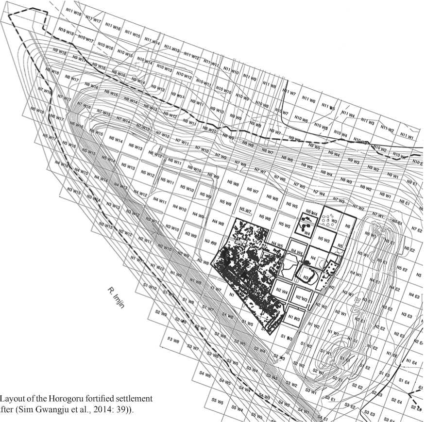
et al., 2014: 39))
С^о
In recent years, geophysical techniques have been put into practice when studying early medieval fortified settlements of the Bohai period. However, the lack of illustrations, entangled methodology, and unclear reconstruction (Bessonova, Koptev, 2015) are barely adequate to the tasks of archaeology. Representative data have been obtained as a result of studying a Bohai grave near the Kraskino fortified settlement (Gelman et al., 2016).
In 2007, prospection studies were conducted at the Horogoru fortified settlement. To perform the groundpenetrating radar (GPR) survey, the Loza-M georadar, having an antenna-operating frequency of 200 MHz, was used. Operation at comparably low frequencies was aimed at identifying the structure and character of subsurface soil layer, and analysis of anomalies arising as a result of anthropogenic activities in the past. Subsequently, the results were compared to archaeological materials, which confirmed or supplemented the obtained data.
Rampart of the fortified settlement
Geophysical studies. A sounding trace, for tracing the longitudinal profile of the site, was routed almost along the entire length of the eastern rampart, to reveal its character and structure (Fig. 2). A reflected high-intensity signal manifested itself in its upper portion: this signal corresponds to the vegetable layer, containing modern disruptions and structureless stone heaps, which are hardly visible. Undulating lines of a positive and negative intense reflected signal are observed below. Red areas, distinguishable in the surrounding soil, may pertain to the rampart’s stone structures. In addition, a GPR profile was routed in the southern part of the rampart to reveal the structure of the cross-section of the internal side of the rampart and the adjacent area of the fortified settlement. A high-intensity reflected signal, which could be interpreted as masonry or a heap of stones on the rampart,
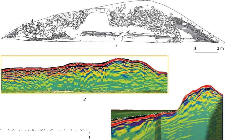
Fig. 2 . Section (after (Sim Gwangju, Jung Nari, Lee Hyeong-ho, 2007: 25)) ( 1 ), longitudinal ( 2 ) and crossing ( 3 ) rampart profiles.
was observed in the upper layers and disappeared at a greater depth. Probably, this was due to the special features of the rampart structure.
Archaeological studies. In 2001, an entrance to the settlement was broken through by a tractor in the southern portion of the eastern rampart (where, probably, the entrance was initially located), following which cleaning of the rampart section was performed, and the rampart construction preliminarily determined (Yeoncheon…, 2009). The rampart is 10 m high, 90 m long, and the width of the base reaches 40 m. The foundation is built of tamped earth layers 1.2 m high and 21 m wide. Loam with crushed stones is spread and tamped thereon (the layer 4 m wide). On the outer side, the rampart is strengthened with two masonry rows 7 m wide. These, in turn, are supported against collapse by a stone prop and tamped clay to a height of 2 m. Later, during the Unified Silla period, the rampart was strengthened from the outside with a sangar, from the central part of which a tower projected (Sim Gwangju, Jung Nari, Lee Hyoungho, 2007: 297–298) (Fig. 3).
Subsequent excavations demonstrated more complex construction in the eastern rampart. Two lines of post holes, each consisting of two parallel rows, were revealed. One of these was located near the fill base on the inner side, while the other one was 2 meters from it, under the rampart. This indicates that at the initial stage the settlement was protected with a wooden palisade, and subsequently fortified with a strong rampart (Sim Gwangju et al., 2014: 48–52; Yeoncheon…, 2011). A palisade was usually erected as a temporary fortification around a fortress during the building stage, until stone walls were constructed. As a rule, it was supplemented by earthwork fortified structures. Such construction was also discovered at other Koguryo ancient settlements and forts in South Korea (Stoyakin, 2015: 272; Yang Si-eun, 2010: 107–108; 2013: 178–182).
Apertures for four vertical posts, located at a distance of approximately 2 m from one another, were found in the stone wall. In front of these, several skewbacks for the posts that strengthened the masonry frame are preserved. Nearby, pottery and roof tile fragments belonging to the Koguryo period were found. A different construction time for the rampart’s external extension, where roof tiles belonging to the Unified Silla period were found (Sim Gwangju et al., 2014: 45–48), was confirmed. On the internal slope of the wall, stones that do not form regular masonry were found, as was, for example, traced at the Bohai Kraskino fortified site in Primorye. The GPR data from the Horogoru rampart were confirmed by archaeological materials.
Internal space of the fortified settlement
The total inner area of the fortified settlement surveyed by the ground-penetrating radar is ca 1500 m2. The survey was performed in an area of 40 × 50 m in size, the distance between profiles laid along a square marking (10 × 10 m) was 1 m. Unfortunately, the limited scope of the GPR studies provided no way of revealing the
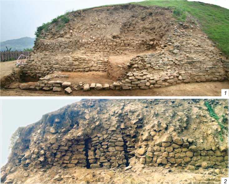
Fig. 3 . General view of the rampart ( 1 ), and apertures for the vertical posts ( 2 ).
whole pattern of the cultural layer within the fortified settlement. When sounding, we tried to embrace maximally the central ground, which might contain important features, but which was not expressed in roughness of terrain. Beyond the settlement, trenches were laid, which revealed the remains of several structures and drainage (Ibid.: 94).
As a result of the GPR study, certain areas showing increased amplitude of reflected signals were identified. Earlier, during exploration works, finds belonging to various subsequent medieval cultures (Koguryo, Unified Silla, and Koryo) were encountered. It can be assumed that this will have an effect on the stratigraphic column. Taking into account the cultural layer’s accumulation rate, the features associated with each culture should be located at different depths. Therefore, analysis of GPR images was focused on identification of anthropogenic strata, such as stone constructions at depths of 33 and 85 cm and, whenever possible, in deeper areas.
For example, a comparatively intense anomaly, in the form of a spread of stones, manifested itself at a depth of 33 cm throughout the entire thickness. Unfortunately, an accurate and complete assessment of the outlines of the structures proved impossible, with some exceptions. Other anomalies, obviously also related to structures, were observed in places at a depth of 85 cm. In deeper areas, anomalies were recorded sporadically, and yielded little information. Nevertheless, we may speak of the probable presence of some ancient buildings and structures.
At the geophysical survey site, archaeological excavations were conducted, leading to the finding of medieval features belonging to various times.
Geophysical and archaeological studies of Koguryo’s objects
Water collection system. The georadar recorded an unusual location for the anomaly in the square N3/W3, not far from the rampart (Fig. 4, 1 ). A high-intensity reflected signal manifested itself in the layer’s upper portion, while a weak signal, correlated with internal filling of the water reservoir, appeared below. Even lower, a high-amplitude anomaly corresponding to the masonry was observed again. Its boundaries had a regular shape in plan view. Below, the signal attenuated again. In the adjacent square N4/W3, an anomaly caused by the drain well was represented in the upper layers, below which a considerable decay of the signal was observed.
The excavations discovered a water collection system (Fig. 4, 3 ; 5, 1 ), consisting of a reservoir (storage basin), which could have been used to accumulate and store water, and an adjacent well, located at a higher level,
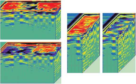
Fig. 4 . Three-dimensional images of the Koguryo layer areas at depths of 33 cm and below 85 cm in the squares N(3–4)/W3 ( 1 ), N3/W4 ( 2 ) and the water reservoir layout (after (Sim Gwangju et al., 2014: 57)) ( 3 ).
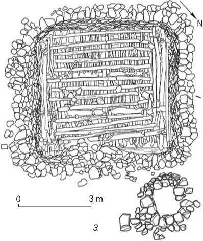
where water was collected before entering the water reservoir. The storage basin has a subsquare shape (7.86 × 7.20 m, 2.68 m deep) in plan view. The walls were lined with gauged stones, and a wooden construction in the form of a cribwork made of different-thickness planks can be traced on the floor.
The filling stratigraphy, wherein seven levels are distinguished, is rather complex. After the water reservoir had been out of service for some time, a dwelling was built at this place, with an L-shaped stone construction (kan, ondol) typical of the Koguryo culture. Large, flat stones for the column pillar were discovered right above the water reservoir; but below the kan, in layer 5. Later, a hearth belonging to the Unified Silla period was located here (Ibid.: 64).
Roof tile heaps. In the square N3–4/ W4, at a depth of 33 cm, a comparatively intense anomaly manifested itself throughout the entire thickness (see Fig. 4, 2 ). It was correlated with heaps No. 1 and 2 of Koguryo roof tiles. No anomalies are traced at a depth of 85 cm, which generally coincides with the archaeological data.
The excavations have demonstrated that heap No. 1 has an irregular round shape in plan view, the dimensions are 8.0 × 7.5 × 0.5 m. The pit was filled with a brown loam containing large number of roof tiles (see Fig. 5, 2 ). A “cord” ornament prevails, “lattice” and sawtooth ornaments are also present. Also, roof end tiles, with lotus ornaments, and finials
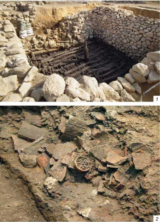
Fig. 5 . Koguryo features.
1 – water reservoir; 2 – roof tile heap No. 1 (after (Sim Gwangju et al., 2014: 75)).
have been discovered. A fragment of a ceramic drum is an interesting find. Heap No. 2, 6.2 × 0.2 m in size, oriented from north to south, was located in the square N3/W4 and partially overlapped heap No. 1 in the southwest. The layer consists of only one row of roof tiles, with a predominately “lattice” ornament.
Geophysical and archaeological studies of Koryo objects
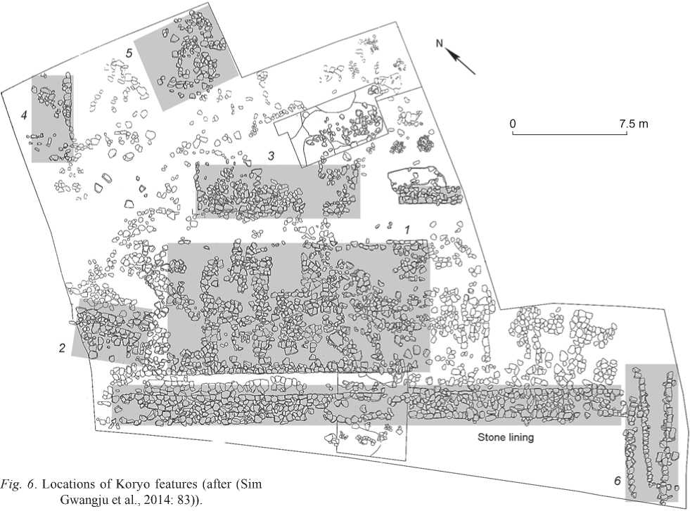
Structures. A large number of stones, which formed masonwork in places, were found below the sub-vegetable layer. To determine the character and cultural affiliation of these features, an excavation unit was established. Remains of seven buildings and a spread of flat stones were identified in the squares N1/W7–N4/W7, S1/W4– N3/W5 (Fig. 6).
This area is characterized by the following stratigraphy: under the first layer, ca 50 cm thick, partially mixed with the sub-vegetable layer, the second layer was located, of light-brown loam with small pieces of calx and abundant roof tiles; the third layer is represented by brown clay (subsoil). Apparently, layer 2, containing roof tiles of the Koguryo and Unified Silla periods, was piled up; later, during the Koryo period, the buildings were erected thereon.
Determination of the spatial planigraphy of features is difficult, owing to the later considerable destruction of the layer, and ancient rebuilding. Nevertheless, building No. 1 is preserved well enough. It was installed on a platform (ca 20 m long and 3.6 m wide) consisting of three masonry levels. Column-bases were discovered inside, which allowed the building’s construction to be revealed. Obviously, it consisted of five spans in length and one span in width. Judging by the size of the building and the surrounding extensions, this structure was the main and central one. A spread of stones (35.0 × 1.8 m) was located in front of it in axial alignment.
The finds are mainly Koryo-type roof tiles. Various types of ornament are also noteworthy: a “herring-bone” design was found on the tiles near buildings No. 1, 3, 7, and a spread of stones, incised lines near building No. 2, and thin linear pattern near buildings No. 5 and 6. Important finds include a bronze mirror with a lotus ornament, and gold-coated silver and bronze belt-plaques.
Both the stratigraphic situation showing many strata and the spatial arrangement of features with various tiles
point to different construction times of Koryo buildings. Buildings No. 1, 3, 7, and probably 4, and a spread with roof tiles ornamented in a similar manner, located along the same NE-SW line, parallel to the river bank, may be assigned to the initial structures.
Ornaments, and a rich belt-set popular in the 11th– 12th centuries (Joo Kyeongmi, 2014), suggest a very high status for their owner in the bureaucratic hierarchy. The Horogoru site is situated in a strategically important location, where the transport route had run between modern Pyongyang and Seoul since the period of the Three States. Near the settlement, there was a river harbor, where local products were collected from the entire basin of the Imjin River until the beginning of the 20th century. Judging by the strategic location of the settlement and the type of finds, it may be assumed that it was a county administrative center during the Koryo period, and that building No. 1 was the residence of an official with a high bureaucratic position.
Roof tile heaps. Heaps No. 3–7 were discovered below the Koryo buildings. Pits No. 3 and 4 are small and round. The first contained tiles belonging to the Unified Silla period. Pit No. 5 is irregular, 5.5 × 4.6 × 0.8 m in size. Four spreads of stones intended for columns, unrelated to this pit, were found in the filling. The majority of roof tiles have “cord” ornaments. Pit No.6, rectangular in plan view and 3.9 × 1.8 × 0.2 m in size, was discovered in the lower part of building No. 7. Roof tiles with saw-tooth ornaments prevail; also, there are many fragments of Koguryo finials. Pit No. 7 is recorded between structure No. 1 and a spread of stones. Here, in the square N1/ W5–6, the most intense anomaly manifested itself at a depth of 85 cm; meanwhile, it was slightly weaker at a depth of 33 cm.
Conclusions
Judging by the data from radiocarbon analysis and dendrochronology, the settlement existed from the middle of the 5th century. The construction time of the rampart is dated to the mid-6th century (Lee Hyeong-ho, 2015: 47– 50). Horogoru, located in a strategically valuable location, had an important defensive function during the Koguryo period. Apart from the rampart, the water collection system and roof tile heaps belong to the epoch. A large number of roof tiles, especially roof end tiles and finials, suggests a high status for the settlement, since roof tiled buildings were high-status in the Middle Ages and served as palaces, government offices, temples, etc. This was probably a district capital during the Koguryo period (Sim Gwangju, Kim Joohong, Jung Nari, 1999: 207–210; Sim Gwangju, Jung Nari, Lee Hyeong-ho, 2007: 302–304).
After the fall of the Koguryo Kingdom in the middle of the 7th century, the settlement was used in Unified Silla for a certain time. At this time, the rampart was completed. However, judging by vigorous building activities, a new start was given to Horogoru during the Koryo period. The county administrative center could have been located here (Jung Yegeun, 2005: 210). Belt ornaments suggest that the central building could have existed in the 11th– 12th centuries.
Unfortunately, the GPR survey results did not allow an accurate and complete assessment of the outlines of the structures, owing to peculiarities of the cultural layer accumulation, and modern disturbances. Nevertheless, a special administrative Koryo building was reconstructed. The data on Koguryo features, except for the water reservoir and roof tile heap, are rather fragmentary and do not give the whole picture.
During excavations, the earliest fortification line of the settlement, unexpressed in the terrain’s relief, was revealed. Subsequently, a strong fortified structure appeared in its place. The structure of the earth rampart, covered with stones, generally represented in the GPR image, is confirmed by archaeological data.
Application of various geophysical methods undoubtedly provides more accurate information about an ancient site, its planigraphy, and structure, which considerably improves the efficiency of archaeological excavations and reduces their costs. For example, the use of a package of geophysical methods (electric profiling, magnetic prospecting, ground-penetrating radar, electrical tomography) at the Uchkakar fortified settlement ensured the possibility of comparative analysis of data, while focused excavations have proved the correctness of their preliminary interpretation (Zhurbin, Ivanova, 2018).
Though prospection studies of medieval fortified settlements in South Korea are still at an early stage, certain results have been achieved. Generally, archaeological excavations at the Horogoru fortified settlement confirmed the data of prospection studies, which points to the necessity of mainstreaming new technologies and methodologies to collect more complete information about the past.
