Geophysical studies at the Kushmanskoye (Uchkakar) fortified settlement, Kama basin
 fortified settlement, Kama basin")
Author: Zhurbin I.V., Ivanova M.G.
Journal: Archaeology, Ethnology & Anthropology of Eurasia @journal-aeae-en
Section: The metal ages and medieval period
Article in issue: 1 т.46, 2018.
Free access
Short address: https://sciup.org/145145355
IDR: 145145355 | DOI: 10.17746/1563-0110.2018.46.1.076-085
Text of the article Geophysical studies at the Kushmanskoye (Uchkakar) fortified settlement, Kama basin
Current requirements regarding the preservation of cultural legacy and the need for greater efficiency in field work are among the reasons why geophysical methods in archaeology are gaining importance. The use of a combination of techniques (such as resistivity, magnetometry and ground-penetrating radar surveys, etc.) provides the possibility of a comparative analysis and of a more detailed knowledge of archaeological sites (Geophysical Survey…, 2008; Rabbel et al., 2015;
Vafidis et al., 2005). The interpretation of geophysical data (correlating anomalies with archaeological features) is based on the results of excavations.
The complex approach was applied in studies of the Medieval Finno-Ugric settlement of Kushmanskoye (Uchkakar), dating to the 9th–13th centuries (Arkheologicheskaya karta…, 2004: 200– 203; Ivanova, 1976; Pervukhin, 1896: 83–86; Spitsyn, 1893: 74) and located in northern Udmurtia (Fig. 1). The geophysical survey has encompassed the whole area that supposedly contains archaeological features
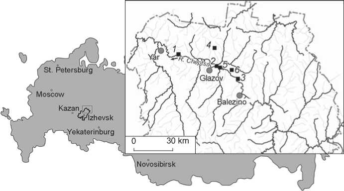
Fig. 1. Map showing the location of fortified settlements attributable to the Cheptsa culture. 1 – Uchkakar; 2 – Idnakar; 3 – Guriyakar; 4 – Dondykar; 5 – Sabanchikar; 6 – Vesiyakar.
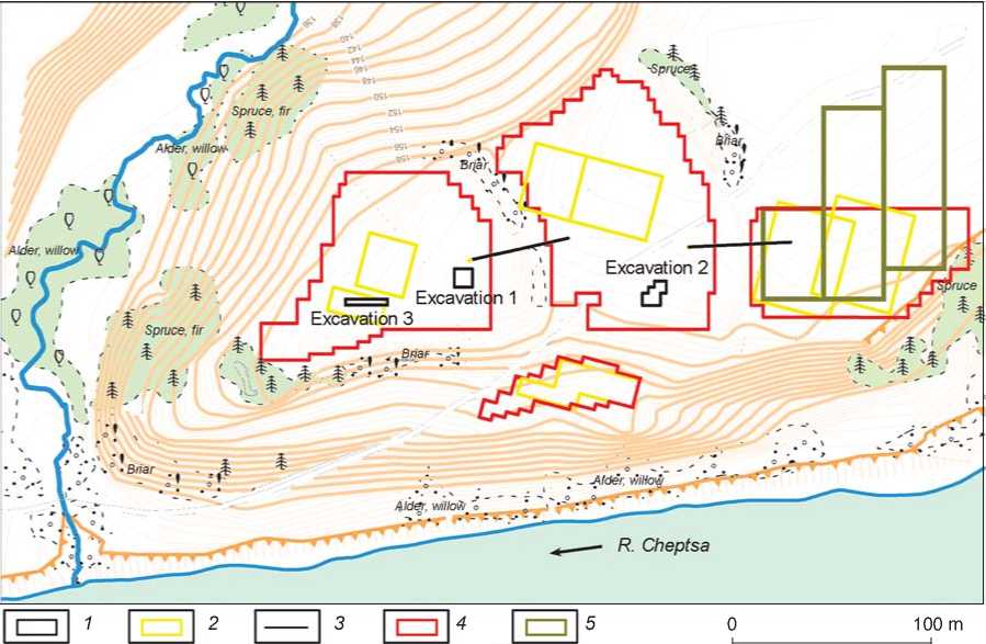
(over 26,000 sq. m): the promontory of the bedrock terrace delimited by fortifications; the terrace scarp between the settlement and the Cheptsa River; and the external part of the settlement located outside the outer fortification line*. Plots of the surveys partially overlapped each other, providing a higher accuracy in interpretation of geophysical data (Fig. 2). Electrical resistivity tomography amplified preliminary interpretations**.
A similar approach to multidisciplinary studies is taken by several institutions. The best known surveys are those by the Institute of Archaeology and Ethnography SB RAS (Novosibirsk), examining the structure of settlements and cemeteries in Western Siberia and the Altai, and those by the Institute of Archaeology RAS (Moscow), focusing on sites in the Suzdal Opolye and the Kislovodsk Basin. The most frequently used technique is magnetometry survey, which is most universal and rapid. However, because archaeological features in northern Udmurtia— specifically, at Uchkakar—are magnetically hard to distinguish from the encompassing grounds, preference was given to resistivity survey.
Interdisciplinary research of the inner and middle parts of Uchkakar
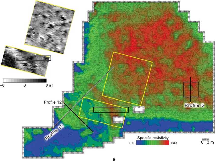
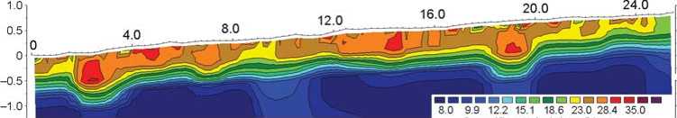
According to the analysis of geophysical data (Fig. 3), two areas, differing in layout and the thickness of the cultural layer, can be distinguished and provisionally the termed inner and middle parts of the settlement. The inner part is located on the spit of the promontory. It is delimited by a bow-shaped fortification line (ditch and clay rampart), not visible in the landscape (Fig. 3, a ). The cultural horizon is actually absent in this area. Just some features deepened into the subsoil were detected: an ellipse-shaped trench measuring 12 by 20 m, and several local pits. The trench adjoins the interior boundary of the clay rampart (Fig. 3, b ; 7.0–19.0 m range). Two large pits up to 1.5 m deep are located in its northwestern and southeastern parts (Fig. 3, c ; 4.0–6.5 m and 15.0–17.5 m ranges). The depth of the local pits does not exceed 0.5 m (Fig. 3, c ; 23.5–25.0 m range). The inner fortification line included the clay rampart and ditch (Fig. 3, b ; 19.0–27.0 m and 27.0–36.0 m ranges). Magnetometry survey confirmed their location and geometric parameters (Fig. 3, a ).
Interdisciplinary studies at Uchkakar included excavations of key features revealed by geophysical prospection (Ivanova, Zhurbin, 2012). The results of the excavations (excavation 3; Fig. 2, 3, a ) supported
Alder, wilk
Aider. willow о
□
□
100 m
-Spnjce^
_«>
Excavation 2
I'
-Alder; >Ail
R. Cheptsa
1 i__j Excavatk
Excavation 3
4'1
4- • л ;*
Spruce, fir
(Г-4 1
•. Spruce, fir •
Araer willow- . "
■ 9/ '
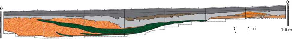
Fig. 2. Topographic plan of Uchkakar (contour interval, 0.5 m; conventional altitude scale) showing location of excavations and geophysical plots (by A.N. Kirillov, with corrections and additions by R.P. Petrov).
1 – excavation; 2 – magnetometry survey plot; 3 – electric resistivity tomography survey line; 4 – resistivity survey plot; 5 – plot of ground-penetrating radar.
the hypothesis that an inner fortification line had been present (Fig. 4), and suggested that after the ditch had been excavated (originally it was 15–16 wide and 1.5 m deep), a rampart was constructed from the subsoil clay. At least two stages in the destruction of the fortifications can be recorded. First, clay sediment from the rampart partially filled the ditch, and soil forming processes started in the upper layers of the fill (layer 2). It is possible that this area was subsequently used (layers 3 and 5). The ditch, partially filled with clay, narrowed to 9–10 m and received low humified loam with coals and organic remains. The described situation is consistent with geophysical prospection. Notably, under the preserved base of the rampart, there was a late rectangular underground structure, possibly utilitarian (Fig. 5). This feature was revealed by resistivity survey (Fig. 3, a ), while a magnetogram did not show it clearly. The presence of this fortification line indicates that the defense system at Uchkakar consisted of inner, middle, and outer parts, the same as at other large Cheptsa settlements such as Idnakar and Guriyakar (Ivanova, 1998: 212-224; Ivanova , 2012: 51; Ivanova, Zhurbin, Kirillov, 2013).
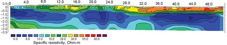
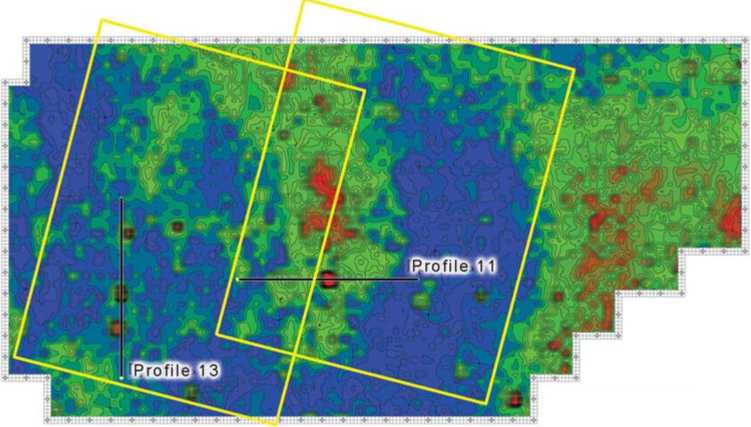
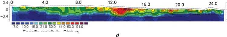
In distinction from the inner part of Uchkakar, the middle part of it is characterized by a thick cultural layer reaching 1.5 m. Combined geophysical survey revealed at least 26 constructions, arranged in six rows, paralleling the fortification lines (Fig. 6). Magnetometry survey allowed us to attribute several vague resistivity anomalies associated with features of the layout. In addition, electrical resistivity tomography was applied to clarify the interpretation. Geoelectric sections “crossing” these anomalies record closed areas of low resistivity: lenses of clay in a heterogeneous humified layer (see Fig. 3, b , 34.0–41.0 m range; d , 7.0–10.5 m range). Geometric parameters and deposition depth can be assessed as well.
Excavations in the area of one of these anomalies (excavation 1; Fig. 2, 3, a ) disclosed a large platform from a dwelling (Ivanova, Zhurbin, 2014: Fig. 4; Ivanova, Kirillov, 2013). A similar platform was discovered in the eastern portion of excavation 3 (Fig. 2, 4). Generally, in terms of composition and excavated features, the cultural layer of the Uchkakar site’s middle part resembles that of other fortified settlements in the Cheptsa basin dating to the
b
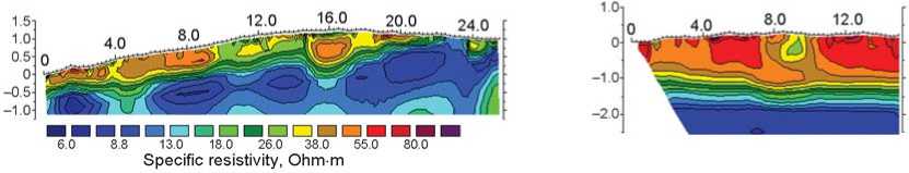
Fig. 3. Results of geophysical studies of the inner and middle parts of Uchkakar.
a – resistivity survey; b – d – electric resistivity sections along electric resistivity tomography line profiles 13 ( b ), 12 ( c ), and 5 ( d ).
1 – excavation; 2 – magnetometry survey plot; 3 – electric resistivity tomography survey line; 4 – looting pit unexamined by geophysical methods.
2 m
123□456□7 □89
Fig. 4. Generalized scheme of the northern profile of excavation 3 (southern view).
1 – speckled light yellow and light tawny clay; 2 – clay from layer 1, affected by soil-forming processes; 3 – gray and dark gray ashy, humified loam, with coals and organic remains; early horizon of the cultural layer (after the abandonment of the inner fortification line); 4 – dark grayish-brown ashy, humified loam between the early and late horizons; 5 – dark gray humified loam (the upper portion is plowed); late horizon of the cultural layer; 6 – buried soil; 7 – dense and partially ignited clay; 8 – dense red clay of subsoil; 9 – turf.
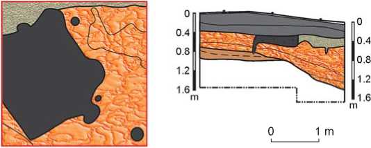
Fig. 5. Generalized scheme of spatial organization and stratigraphy (western side of the excavation) of the late construction on the clay rampart in the inner fortification line.
1 – speckled light yellow and light tawny clay; 2 – dark gray ashy, humified loam with decayed wood; 3 – dark loam with coals; 4 – buried soil; 5 – dark gray humified loam (the upper portion is plowed); late horizon of the cultural layer (after the abandonment of the inner fortification line); 6 – turf.
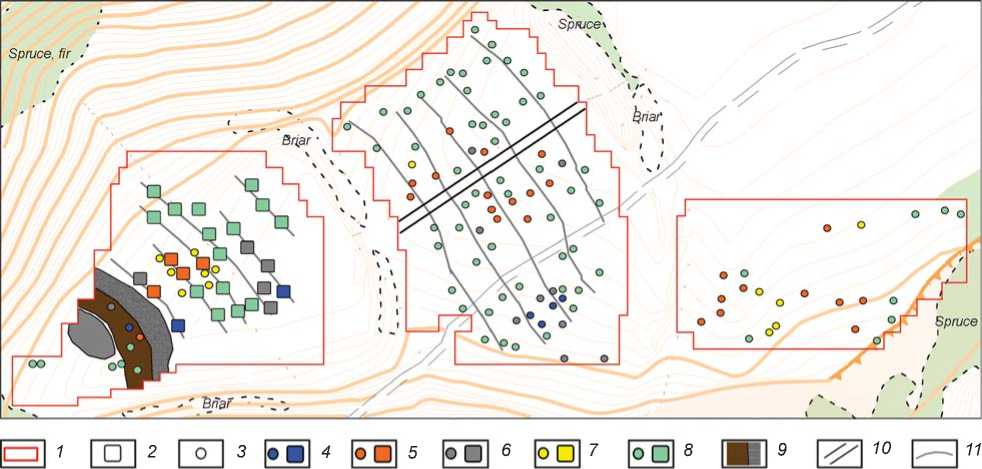
Fig. 6. Reconstructed layout of Uchkakar.
1 – resistivity survey plot; 2 – clay platform; 3 – pit; 4 – features recorded by geophysical studies and confirmed archaeologically; 5 – features recorded by resistivity and magnetometry surveys; 6 – features recorded by resistivity survey and electrical resistivity tomography; 7 – features recorded by magnetometry survey only; 8 – features recorded by resistivity survey only; 9 – clay rampart and ditch of the inner fortification line; 10 – trench of 1930 by A.P. Smirnov; 11 – probable orientation of the rows of constructions.
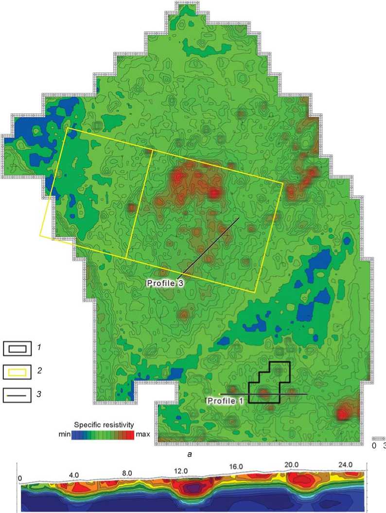
Profile.3
P rofile-1
Specific resistivity mine■illffl^™max
■^и
Specific resistivity, Ohm m
c
Fig. 7. Results of geophysical studies of the outer part of Uchkakar.
a – resistivity survey; b , c – electric resistivity sections along electric resistivity tomography line profiles 1 ( b ) and 3 ( c ). 1 – excavation; 2 – magnetometry survey plot; 3 – electric resistivity tomography survey line.
9th–13th centuries: Idnakar, Guriyakar, Vesiyakar, Dondykar, and Sabanchikar (Fig. 1).
A large terrace is located on the southeastern side of Uchkakar’s central area. It begins from near the spit of the promontory and extends to the outer rampart (Fig. 2). Magnetometry and resistivity surveys revealed no archaeological features there.
Interdisciplinary research of the outer part of Uchkakar
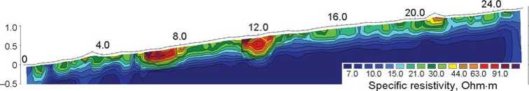
The outer part of the settlement is delimited by two fortification lines identifiable by visual inspection: the middle and outer ones (Fig. 2, 7, a). The cultural layer had been destroyed by plowing. Thicker deposits have been registered in the central part (high resistivity zone). Only deepened features (ca 80 pits) were recorded there. Five indistinct rows of pits, rather evenly distributed over the outer part of the settlement, can be traced (Fig. 6). Resistivity survey allowed us to identify pits of two major types: 3–4 m in diameter (Fig. 7, b) and 1.5–2.0 m in diameter (Fig. 7, c). In most cases, pits of a larger size induce bipolar magnetic anomalies composed of combined negative and more intense positive parts. This suggests that these pits were associated with production premises (they were filled with slag, ceramics, ash from hearths, etc.). Smaller pits are normally recorded as areas with high magnitudes of magnetic field without distinct adjoining “negative” anomalies. Anomalies of this sort can be associated with pits deepened into the subsoil and filled with humified sediment.
Excavation 2 revealed diverse features (Fig. 2, 7). Among them, two pits of various types were studied completely (Fig. 8, a ). Excavations showed that one of the “large” pits recorded through resistivity survey (Fig. 7, b , 11.0–15.0 m range) consists of two features located one above another: a later round pit and an earlier square pit framed by boards, which were fixed by poles standing in the corners (Fig. 8, b ). The presence of slag, plaster, fragments of bronze artifacts, a foundry ladle, and a three-sided mold suggests metal casting (Ivanova, 2014; Ivanova, Modin, 2015). The geometric parameters of the pits, and the character of the archaeological remains, agree well with the geophysical data.
Comprehensive geophysical measurements at the middle part of Uchkakar have revealed the area where the trenches excavated by A.P. Smirnov in 1930 crisscrossed each other (confirmed by excavations), and subsequent studies enabled the identification of the location of the trench on the outer part (Fig. 6).
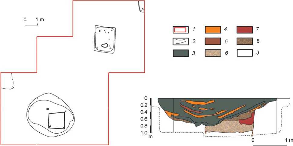
Fig. 8. Spatial organization ( a ) and stratigraphy ( b ) of the pit in excavation 2 in the outer part of Uchkakar.
1 – border of the excavation; 2 – border of features; 3 – dark gray humified loam with coals and ash; 4 – tawny and light tawny clay;
5 – dark brown and whitish-brown loam; 6 – mixed layer (light loam and tawny clay with coals and decayed wood); 7 – loose red clay with a small content of gray loam and coals; 8 –free soil infill on the bottom of a late structure; 9 – subsoil.
0 3 m
Specific resistivity mi n Я^Щ L 11 ЯП ma x
а
c
Specific resistivity. Ohm m
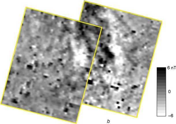
Fig. 9. Results of geophysical studies of the unfortified external part of Uchkakar.
a – resistivity survey; b – magnetogram; c , d – electric resistivity sections along electric resistivity tomography line profiles 13 ( c ) and 11 ( d ).
Geophysical researchon the unfortified external part of Uchkakar
Outside the outer fortification line (Fig. 2), the cultural layer was also significantly disturbed (Fig. 9, a ). Magnetometry survey (Fig. 9, b ) and electrical resistivity tomography (Fig. 9, c , d ) revealed several subrectangular pits measuring approximately 2 by 2 m and up to 1 m deep. On the magnetogram, such pits correspond mostly to bipolar anomalies. In addition, randomly spaced pits of smaller sizes were recorded. Some of these correspond to local anomalies of higher resistivity, others to areas with high magnitude of magnetic field. No regularities in the arrangement of features can be seen beyond the fortification line (Fig. 6).
Ground-penetrating radar detected no archaeological objects. However, geological features were recorded in that area. In particular, a local zone with a high content of carbonates was revealed in the center of the plot (the bedrock in the settlement’s area is carbonate reddish-brown Permian clay with lime rock particles). This peculiarity is registered by magnetometry and resistivity surveys, as well as by electrical resistivity tomography (Fig. 9). The ground-penetrating radar then makes it possible to disregard natural anomalies revealed by the magnetometry and resistivity surveys.
For the first time at the site associated with the Cheptsa culture, the survey has revealed cultural deposits beyond the fortification line––a finding that is highly relevant to the archaeology of the region.
Conclusions
The geophysical studies at Uchkakar resulted in important findings. A hitherto unknown fortification line representing a structural unit of the site was revealed. The general layout was reconstructed, and each structural unit was examined in detail with regard to the thickness of the cultural layer and the shape of features. The structures and sizes of all three fortification lines were evaluated, and features outside the visible settlement border were detected.
As the interdisciplinary investigations have demonstrated, resistivity survey is the most relevant geophysical method for studying settlements of the Cheptsa culture. Magnetometry survey s and groundpenetrating radar are the most suitable methods for general reconstruction of the layout, and electrical resistivity tomography is optimal for a detailed assessment.
At Uchkakar, prospection-guided excavations focused on various structural features, accounting for less than 1 % of the site’s area: the inner fortification line, constructions in the middle part, and a group of pits in the outer part. The findings were matched with the combined geophysical map, which allowed us to specify the nature of geophysical anomalies and to reconstruct the general layout of the settlement.
Acknowledgement
This study was supported by the Ural Branch of the Russian Academy of Sciences, “Traditions and Innovations in History and Culture” Program (Project No. 15-13-26-4).
