Integrative geophysical studies at the Novaya Kurya-1 cemetery in the Kulunda steppe

Author: Pozdnyakova O.A., Marchenko Z.V., Grishin A.E., Balkov E.V., Dyadkov P.G., Evmenov N.D.
Journal: Archaeology, Ethnology & Anthropology of Eurasia @journal-aeae-en
Section: The metal ages and medieval period
Article in issue: 4 т.49, 2021.
Free access
Short address: https://sciup.org/145146411
IDR: 145146411 | DOI: 10.17746/1563-0110.2021.49.4.069-079
Text of the article Integrative geophysical studies at the Novaya Kurya-1 cemetery in the Kulunda steppe
Geophysical research methods have been used in archaeological practice worldwide for a long time. Geoelectric studies have been used for more than 80 years, and magnetic prospecting has been used for more than 60 years (Korobov, 2016). The experience gained shows that the tasks of the search for, and diagnostics of, the structure of archaeological sites can be successfully resolved with the aid of nondestructive geophysical methods. Currently, geophysical research in archaeology is one of the most dynamically developing areas of interdisciplinary cooperation. This rapid growth is largely due to the continuous development of hardware and software in geophysics providing new opportunities for archaeological studies.
Fig. 1. Location of the site of Novaya Kurya-1.
Another factor of sustainable productive development is the long-term and multipurpose joint research carried out by the specialized institutions. These approaches make it possible to constantly improve the methodology of archaeological and geophysical works by testing new methods, and checking the results of geophysical reconstructions by excavations. The collaboration between the Institute of Archaeology and Ethnography and the Institute of Petroleum Geology and Geophysics (IPGG) SB RAS, lasting for over 20 years, is among the examples of such interaction. Over the years of collaboration, the whole range of methods, including magnetometry, electromagnetic profiling, electrotomography, and ground-penetrating radar, has been used; research has been carried out at various archaeological sites in the steppe and forest-steppe regions of the south of Western Siberia, Altai, Mongolia, Khakassia, the Aral Sea region, and India (Jammu and Kashmir). We were able to disclose fully the advantages of combining different methods, which makes it possible to gain comprehensive information about the subsurface locations of objects, their parameters and structures (see, e.g., (Epov et al., 2012; Epov, Molodin, Manshtein et al., 2016)).
In recent years, new prospects have opened up in the field of archaeogeophysics associated with the development of UAV technologies. Installation of geophysical equipment on unmanned vehicles significantly increases the productivity of work and makes it possible to survey vast areas in a short time. Taking into account the innovative nature of these technologies, for their introduction into archaeological and geophysical research, it is necessary to test them using verification of the findings by traditional geophysical methods. In 2019, such works were carried out at the plowed kurgan cemetery of Novaya Kurya-1, located on the Goryachy Dol range, 3 km to the southwest of the village of Novaya Kurya, in the Karasuksky District of the Novosibirsk Region (north of the Kulunda steppe) (Marchenko et al., 2019) (Fig. 1). The cemetery is composed of eight prominent mounds, 20–35 m in diameter and 0.2–0.8 m high. In the course of works, well-known methods of ground-based magnetic survey, electrotomography, and electromagnetic profiling were supplemented by aeromagnetic survey and aerial photography. In addition to testing the new technologies, the purpose of the integrative geophysical studies was to specify the features of the internal structure of the mounds, to search for artifacts in the spaces between mounds, and to identify the boundaries of the site.
Technique and methods of geophysical research
Ground-based magnetic survey. Magnetometry is one of the most widely used geophysical methods in archaeology, because under favorable conditions, this method makes it possible to derive an actual map of the site. To conduct a ground-based magnetic survey of the Novaya Kurya-1 cemetery, a system of grids of 30 × 30 m was established. Since the research tasks included the search for small objects, in order to improve the quality of works, all study areas were scanned with a metal detector in low sensitivity mode, to remove from the tilled layer only the large modern iron items (which produce big gradients of magnetic anomalies and interfere with the recognition of archaeological objects).
The geomagnetic field induction module was recorded with the aid of a cesium magnetometer-gradiometer G-858G (Geometrics, USA) using the vertical gradient method. The sensors were located at altitudes of 40 and 115 cm from the ground. The operator moved along the parallel profiles at a speed of ca 4 km/h, which at a survey frequency of 10 Hz made it possible to take measurements every 10–12 cm. The distance between the arbitrary profiles was 1 m. The total area of magnetic mapping was 23,550 m2. Data were processed using the Surfer program (Golden Software, USA); after that, maps of the vertical gradient of the module of the magnetic induction vector were constructed.
The parameters derived through survey along the profiles passing through centers of the identified archaeological objects were estimated by means of numerical modeling (Evmenov et al., 2020). For this, the data on the anomalous magnetic field derived at two levels of ground-based survey (40 and 115 cm high) were correlated with the results of additional measurements at altitudes of 175 and 250 cm above the ground. When constructing maps and plots of the anomalous field, the data of the variation proton station MV-07M (Geomer, Kazakhstan) were used to exclude the effect of external geomagnetic variations.
Aeromagnetic survey and aerial photography. Aeromagnetic surveying in mineral prospecting has been used for a long time and produced good results. Foreign (Geometrics, GEM, Scintrex, Bartington) and domestic (Geoscan) firms produce serial equipment for mounting on the platform of an unmanned aerial vehicle (UAV) (Balkov, Karin, Pozdnyakova, Dyadkov, 2020). However, this method has been rarely used in archaeological projects (Epov, Molodin, Pozdnyakova et al., 2016; Tishkin et al., 2017; Goglev, 2018; Firsov et al., 2018; Tataurova et al., 2018; Schmidt, Becken, Schmalzl, 2020). Therefore, researches aimed at determining the capabilities of the method for studying various types of archaeological sites remain highly relevant.
Aeromagnetic survey of Novaya Kurya-1 was carried out using the Geoscan 401 Geophysics complex (Geoscan, Russia). Measurements were performed through a high-precision quantum magnetometer of an original design. An industrial quadcopter with the function of flying along a stated route was used as a carrier. The advantage of this complex is that both aeromagnetic and aerial photography can be performed using a single carrier (Goglev, 2018).
The total aeromagnetic survey area was ca 10 ha (500 × 200 m); the total length of the profiles was ca 100 km. The device moved along the profiles at a speed of ca 5 m/s, which at a survey frequency of 10 Hz made it possible to take measurements every 0.5–12 cm. The average height of the survey was ca 5 m, the distance between the profiles was ca 1 m. On the basis of the results of data processing carried out by the specialists of the IPGG SB RAS (Balkov et al., 2019), maps of distribution of the module of the anomalous magnetic field induction vector were constructed, taking into account external geomagnetic variations.
In contrast to aeromagnetic survey, aerial photography is increasingly often used in archaeological studies. The resulting orthophotomaps and digital elevation models have a high degree of resolution and in some cases provide quite sufficient information about archaeological objects, as the geophysical methods do (Vavulin et al., 2021). The total area of aerial photography at Novaya Kurya-1, performed using the Geoscan 401 Geophysics complex, amounted to almost 25 ha (700 × 350 m). Data processing was carried out using an original approach to constructing maps of relative heights, which reduces the effect of natural relief and highlights anthropogenic altitudinal anomalies (Balkov, Karin, Pozdnyakova et al., 2020).
Measurements of the magnetic susceptibility of soils. To increase the reliability of interpretation of the results of the magnetic survey at Novaya Kurya-1, the magnetic susceptibility of soils and underlying rocks was assessed. Measurements were performed using magnetic susceptibility meters MP-01 (Kazgeofizpribor, Kazakhstan) and SM-30 (ZHinstruments, Czech Republic). Average values for soils were 60–80·10-5 SI, for underlying rocks 20–35·10-5 SI. The noted contrast (30·10-5 SI) is sufficient for distinct anomalies to be generated over archaeological objects provided that there are significant amounts of soil in their fillings (Pozdnyakova, 2020).
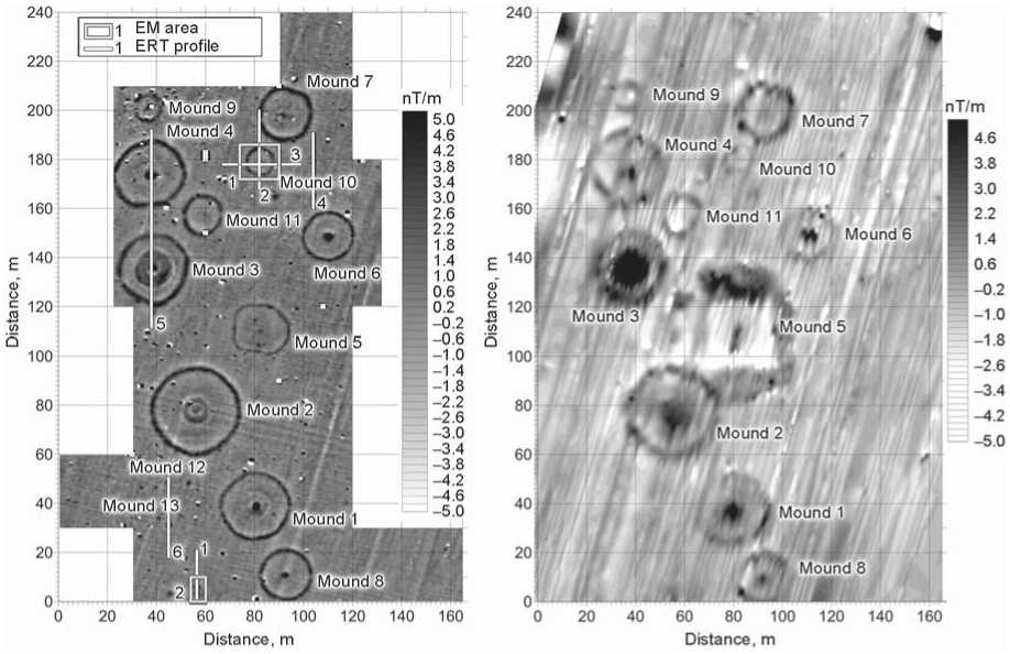
Electrotomography. The resistivity method in electrotomography makes it possible to study the structure of archaeological objects with the presence of resistivity contrast with the host environment (Balkov et al., 2012). In the course of the research, the modern Russian device Skala-64K15 (OOO Electrometry Design Bureau, Russia) was used, which shows high performance through the use of 15 parallel measuring channels. At Novaya Kurya-1, six profiles were measured. The distance between the electrodes along each profile was 0.5 m. Profile 5 (80 m long) ran through the center of visible mounds 3 and 4. Other profiles (31.5 m long) were intended for distinguishing the features of the invisible objects detected by magnetic survey.
Electromagnetic profiling. The EMC equipment developed at IPGG SB RAS is a multifrequency three-coil induction sonde, with the function of compensation of the transmitting-coil primary field with two opposing receiving coils (Manshtein, Panin, Tikunov, 2008). The measured signals are processed by transformation into apparent resistances, and the results are presented in the form of maps of distribution of apparent resistivity values. This method was used to duplicate all the electrotomography profiles and to perform frequencysounding on two areas measuring 14 × 16 and 6 × 10 m. The distance between the measurements along the profiles was 0.5 m, between the profiles 1 m. The test areas, like the profiles, were established relying on the ground-based magnetic survey data.
Study results
Ground-based magnetic survey. The generated map (Fig. 2) clearly shows the small intense anomalies of magnetic field gradient, with an amplitude of more than 30 nT, associated with iron items. Against the general rather calm magnetic background (up to 1 nT), traces of plowing are well recorded in the form of alternating positive and negative linear anomalies in the magnetic field, reaching the values of 9 and –3 nT, minus the
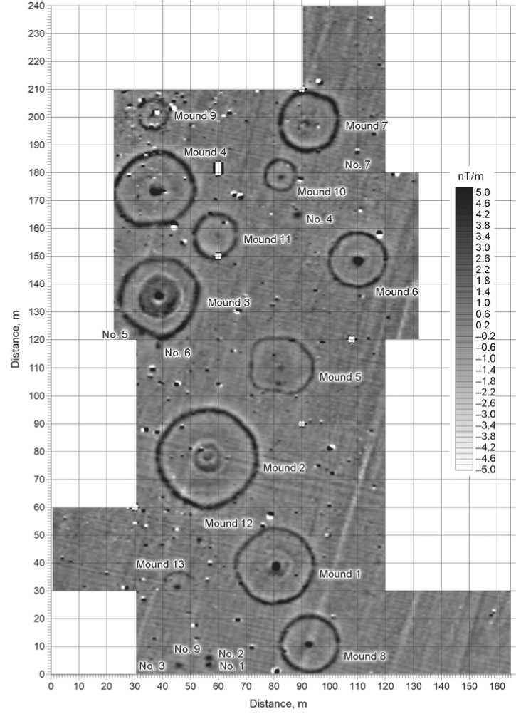
Fig. 2. Gradient distribution of the magnetic field (module of the magnetic induction vector) according to the ground-based magnetic survey results.
signal from iron items. The low values suggest that the emergence of positive anomalies was associated with a local increase in the thickness of the humic layer. This is also confirmed by the results of measurements of the magnetic susceptibility of the soils.
All prominent structures are well traced by positive anomalies; with most of them being characterized by a common set of features. Ring-shaped ditches with passages along the W-E line are clearly recognizable. The amplitudes of the associated anomalies reach 5 nT. The outer perimeter of the ditches correlates well with the visible borders of the mounds. In the center of almost all mounds, rounded anomalies 8–14 m in diameter are distinguished, apparently reflecting the structural features of the mounds. Some of them are characterized by increased values up to 4 nT (mounds 2 and 3). The magnetic parameters of the rest of the area bounded by the ditch are close to the background ones. In the center of the mounds, anomalies with an amplitude up to 9 nT are clearly recorded, which may be due to penetrations by looters. In the space between the prominent structures, small mounds 8–9 to 17 m in diameter (mounds 9–13) with similar configuration were identified. The common features indicate that all these objects represent a onetime burial ground.
Among the visually recorded structures, only mound 5 demonstrated a markedly different organization of the internal structure. Excavation findings (Marchenko et al., 2019) and radiocarbon dating of horse bones from burial 1 (1029 ± 21 BP, MAMS-46646) suggest its attribution to the Late Early Middle Ages, corresponding to the period of the Kimek-Kipchak union in the regional history (Kishkurno, Marchenko, Grishin, 2020). The comparison of archaeological and geophysical data showed that the objects of mound 5 were well recognizable on the maps, owing to the presence of a significant amount of humic soil in their fillings.
In the space between mounds, several positive anomalies with amplitudes of 4–5 nT were recorded, which can be confidently associated with burials or pits. Three of them were located near mound 8 (objects No. 1–3), and one between mounds 6 and 10 (object No. 4). Noteworthy also are two similar anomalies at the southern edge of the ditch of mound 3 (objects No. 5 and 6). The amplitudes of the rest of the anomalies hardly differ from the background values. Among these, only one structure, located between mounds 6 and 7 (object No. 7), is identified with the greatest probability. Its shape is close to an oval; it is oriented along the SW-NE line, and is ca 7 × 11 m in size.
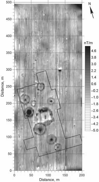
Aeromagnetic survey and aerial photography. The generated maps (Fig. 3, b; 4) clearly show local ring-shaped structures with an amplitude up to 10 nT, corresponding to mounds 1–4 and 6–11, distinguished against the background of regional changes in the magnetic field (up to 20 nT). The research method shows a high degree of correlation with the results of groundbased magnetic survey and a high degree of detail. It was possible to record anomalies associated with ditches, looting pits, and structural differences in the mounds. The anomalies produced by objects No. 1, 2, and 4 are quite distinct (see Fig. 2; 3, b). Other objects were not identified, owing to the insignificant contrast of their fillings with the host environment.
An analysis of the complete aeromagnetic survey map (see Fig. 4) suggests that outside the area of the archaeological site there are no magnetic anomalies produced by mounds. However, noteworthy are point positive anomalies 50–100 m north of the boundary of the ground-based survey area. These can be tentatively interpreted as archaeological objects.
On the basis of the aerial photography results, a digital elevation model was built. The map of absolute heights (Fig. 5, a ) clearly shows all the mounds prominent in the relief. Additionally, a map of relative heights for the area in which the mounds were concentrated was constructed (Fig. 5, b ), which supplemented significantly the information rendered from the magnetic surveys. At the location of mound 11 and objects No. 1–3 (see Fig. 2; 5, b ) it was possible to identify the remains of plowed mounds ca 15 and 25 m in diameter. In addition, 50 m to the north of the boundary of the ground-based survey area, the presence of another mound (object No. 8) can be assumed.
Electrical survey. The results of the electrical survey, which was based on the ground-based magnetic survey data (see Fig. 3, a ), have shown fairly good contrast in resistivity between the archaeological objects and the host environment. Taking into account previously available information, it can be assumed that the upper level of the section, up to 0.5 m deep, is a layer of chernozem soil (resistance range is 130 Ohm·m and above). Below it, up to a depth of 2 m, there are loamy soils (resistance range is 130–150 Ohm·m); further below there is probably a layer of clays saturated with water to various degrees (resistance range is 130–200 Ohm·m).
The results of the electrical survey at the plow-destroyed mound 10 have shown that the greatest contrast appeared in the phase of the signal recorded by the EMC equipment. The map generated from the data of electromagnetic profiling (Fig. 6, a ) represents the outlines of the ditch, but not as clearly as on the magnetogram (Fig. 6, b ). The anomaly in the center of the mound does not have a simply oval shape (as on a magnetic map), but consists of three parts, probably associated with three separate disturbances of the upper layer. In the geoelectric section, according to the electrotomography data (Fig. 6, c ), high resistivity anomalies are recorded in the areas of the ditch intersection and in the center of the mound. The center
b
Fig. 3. Results of the integrative studies at Novaya Kurya-1. a – scheme of the electrical survey observations by electromagnetic profiling and electrotomography methods on the ground-based magnetic survey map; b – fragment of the map of distribution of the anomalous magnetic field (module of the magnetic induction vector) according to the UAV survey results.
а
of the mound is characterized by three local resistivity peaks from 200 to 300 Ohm·m. These anomalies are similar in shape to the central anomaly on the electromagnetic profiling map (4.5 m long, up to 0.7 m deep). The ditch surrounding the mound is associated with vertical high-resistance (up to 500 Ohm·m) disturbances of the conductive layer, 2.5 m long in plan view and 0.9 m deep. Similar values were also obtained for mound 13, the southern part of which had been significantly disturbed by soil-tilling (see Fig. 2; 3, a ).
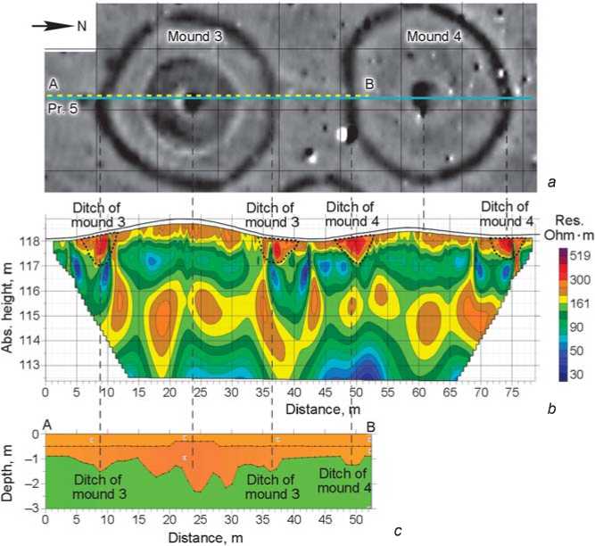
Fig. 7 shows the results of the inversion of the electrotomography and varying-altitude magnetometry data of prominent mounds 3 and 4, in the form of twodimensional sections. The geoelectric section (Fig. 7, b ) shows high resistivity anomalies (200–500 Ohm·m) ca 5 m wide and not exceeding 1.5 m deep at all four points of ditch intersection. The mounds are made up of high-resistivity soils (200–400 Ohm·m) with a thickness of less
Fig. 4. Gradient distribution of the magnetic field (module of the magnetic induction vector) according to the UAV survey results.
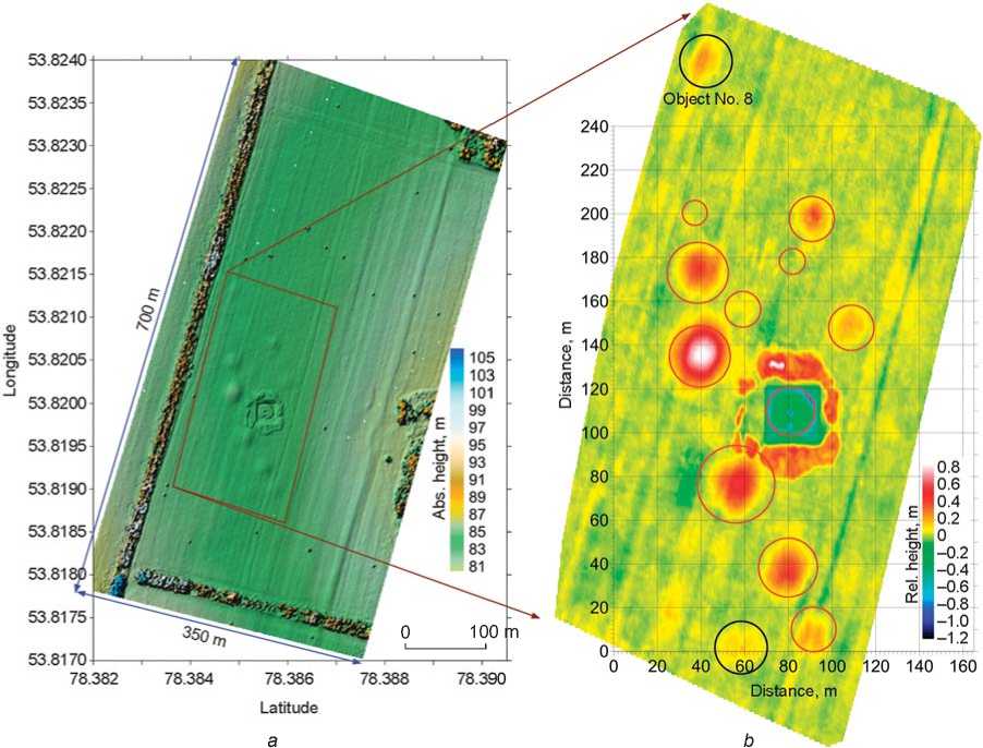
Fig. 5. Digital elevation model of Novaya Kurya-1 according to the aerial photography results.
a – map of absolute heights; b – map of relative heights (plowed burial mounds identified through aerial photography are marked with black color).
than 1 m. In the central part of mound 4, the upper layer is deeper, up to 0.7 m. The section constructed according to the results of magnetic survey at various altitudes (Fig. 7, c ) shows that the depths of the ditches correlate quite well with the electrotomography data, and that the number of central anomalies is higher than in the geoelectric profile, which may be associated with overestimation of their thickness due to the use of a two-dimensional approach to inversion of a 3D local body.
Objects No. 1 and 2 (see Fig. 2; 3, a) correspond to the resistivity anomalies, which are 1.0 and 2.5 m wide respectively, and 1.5 and 1.0 m deep. Nearby, another object (No. 9), ca 1 m wide and 1.8 m deep, was identified by the electrical survey. Anomalies from objects No. 1 and 9 look atypical as compared to the rest. They are clearly vertically structured because of the deepening of the upper layer of high resistance into the underlying layers. Since the third underlying layer is close to the upper one in terms of resistivity, it is difficult to determine accurately the lower boundary of these objects. It was not possible to obtain additional information on object No. 7. This is consistent with magnetic survey data, according to which this object likely has a small depth.
Characteristics of the Novaya Kurya-1 kurgan cemetery based on the data of the integrative geophysical studies
On the basis of visual inspection, eight mounds were identified at Novaya Kurya-1. The consequences of long-term soil-tilling did not allow us to determine their arrangement or to assess the layout and boundaries of the cemetery. The results of the present study make it possible to characterize this site at a markedly different level.
The most significant amount of information was gathered using ground-based methods of magnetic and electrical survey. On the basis of all the data, it was established that all prominent mounds (except for mound 5) constitute a single complex. The most peculiar elements of their structure are rounded objects with diameters of 8–10 to 14 m in the center of the
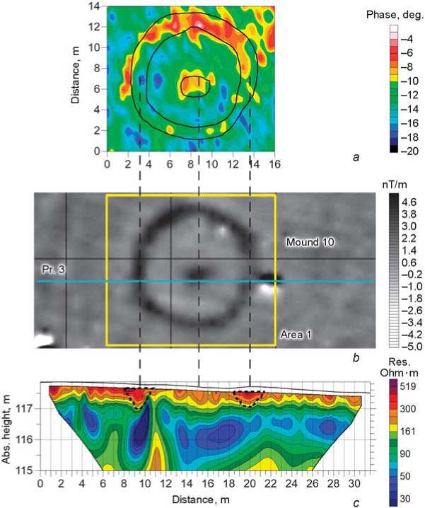
Fig. 6. Results of the electrical survey works at mound 10.
a – phase distribution of differential signal according to the data of electromagnetic profiling carried out using EMC equipment at a frequency of 5 KHz; b – fragment of the map of the magnetic field gradient; c – geoelectric section according to the data obtained by electrotomography using Skala-64K15 equipment.
barrows. They showed up well on magnetic maps, but were not recorded by electrical survey. Thus, in terms of resistivity, these objects do not differ from the rest of the mound, but are characterized by significant differences in magnetic properties. An analysis of the data on the anomalous magnetic field derived from the ground survey at two altitudes showed that the amplitudes of the associated anomalies differ quite significantly: from close to background values up to 8–12 nT for mounds 2 and 3. The increased values are comparable to those for ditches, which, according to the electrical survey data, are filled with soil erosion products. Considering the above, these objects most likely are structures made of soil, where humic material is present in varying concentrations. Apparently they were erected directly above the burial platform, after which barrows were constructed. No pits significantly deepened into the mainland, which can be associated with burials, have been recorded under the mounds.
In addition to the prominent mounds 1–4 and 6–8, the cemetery
Fig. 7. Results of the integrative studies at mounds 3 and 4.
a – fragment of the map of the magnetic field gradient; b – geoelectric section according to the data obtained by electrotomography using Skala-64K15 equipment; c – section generated by the inverse modeling of the layered ground according to the results of magnetic survey at various altitudes.
apparently includes mounds 9–11. These had been completely destroyed through plowing because of their small sizes (11–17 m in diameter). The analysis of the digital elevation model made it possible to identify the remains of mound 11.
Other archaeological features identified in the space between mounds likely belong to the same complex. However, this cannot be stated unambiguously. Magnetic anomalies at the southern edge of mound 3 (objects No. 5 and 6), which is characterized by specific features, can be preliminarily interpreted as associated ritual structures. Mounds 12 and 13, 8 and 12 m in diameter, respectively, were identified owing to the detected remains of shallow ditches. The elevation recorded above objects No. 1–3 and 9, according to the map of relative heights, is most likely the remains of two small burial mounds. The anomaly between mounds 6 and 10 (object No. 4) shows similar characteristics. The interpretation of the oval structure identified between mounds 6 and 7 (object No. 7) is the most difficult. The structure contains very little magnetic material and is apparently very slightly deepened into the virgin land. The data from the digital elevation model suggest the presence of a heavily plowed mound, which allows us to interpret this object tentatively as a burial complex.
According to the results of the integrative geophysical studies, most of the identified objects can be confidently attributed to the Early Scythian time. Taking into account the revealed specificity of the mounds’ construction and the location of the site (Northern Kulunda), it is highly probable that it belonged to the Tasmola historical and cultural community (the 8th to 5th centuries BC). It is generally assumed that the distribution area of the Tasmola culture included the regions of Central (Tasmola culture) and Northern (Ulybay-Tasmola culture) Kazakhstan and Southern Trans-Urals (Bobrovka-Tasmola culture) (Tairov, 2017: 20; Beisenov, 2017). Recently, sites of the Tasmola culture have been reported in the Novosibirsk Region (Avtushkova, Plakhuta, 2020). Tasmola burial mounds were built over separate burials. There are also burials made on the daylight surface or in shallow pits. A characteristic feature is a dome-shaped structure above the grave, which could have been built of sod and soil blocks (rolls). From above, it was covered with soil taken from the adjacent territory. The mounds are often surrounded by a doublering fence made of stones or ditches: one ring at the mound’s base, the other at a distance of 2–5 m from it. In this regard, it is interesting to note that along the edge of the central structures in mounds 1–3, anomalies close to negative values are clearly recorded. These can be tentatively interpreted as internal ditches.
The aeromagnetic survey and aerial photography make it possible to establish the boundaries of the cemetery. Since large mounds are well distinguished on the generated maps, it can be concluded that outside the boundaries of the site, there are no more such structures. Another mound (object No. 9) can be possibly identified on the map of relative heights, but this assumption needs to be verified. Comparison of magnetic survey data shows that small archaeological objects (burial mounds, pits) are not always detected by aeromagnetic mapping. The main reason is their low contrast with the host environment, as well as a significant measurement height. Taking this into account, the presence of such objects outside the ground survey area cannot be ruled out. It is advisable to plan further ground-based geophysical works. According to the aeromagnetic survey data, the most promising is the expansion of the study area in the northern direction.
Conclusions
The results of the archaeological and geophysical works at the Novaya Kurya-1 cemetery clearly demonstrated the advantages of an integrated approach to research. The high efficiency of ground-based magnetic survey was confirmed, as well as the expediency of planning a network of electrical survey observations based on magnetic maps. This approach will optimize the works associated with identifying the layout of the monument, and determining the spatial parameters and structures of individual objects. The verification of the results of magnetic surveys at various altitudes using geoelectric methods proved to be a promising method for further development. This will expand the possibilities of magnetic prospecting for the remote determination of the layout, features, and spatial parameters of archaeological structures.
The studies have proved the high efficiency and prospects of using the aeromagnetic survey method for the study of burial mounds. Its application significantly increases the productivity of magnetic survey; however, identification of small low-contrast archaeological objects in relation to the host environment is often problematic. The technical accuracy of the instruments installed on the UAV is not inferior to the characteristics of the equipment for ground-based survey, but in order to achieve the precision required for archaeological works, it is necessary to use differential GPS-receivers. In this case, the spatial measurement accuracy will approach the sub-decimeter accuracy, which will increase the precision of the images of observed anomalies. Nevertheless, even at the current stage of its development, the aeromagnetic survey method makes it possible to successfully detect and identify the mounds and determine their general structure. The broad usage of this method can significantly change the situation with the study and protection of the burial mounds damaged by soil-tilling, which are the largest category of archaeological sites in Eurasian steppes.
The combined use of aeromagnetic survey and aerial photography produces very good results. Both methods are highly productive, and rapidly provide diverse information about a site. The construction of maps of relative heights makes it possible to detect heavily destroyed mounds that cannot be distinguished visually or by using geophysical methods. On the basis of the experience gained, we would recommend the use of aeromagnetic surveying and aerial photography at the initial stage of research, which will optimize the groundbased geophysical works. This is very important in the study of burial mounds, especially those destroyed by soil-tilling, since they occupy vast areas.
The derived results determine good research prospects for Novaya Kurya-1, both as a platform for further methodological works and as an archaeological site. Even small targeted test excavations can significantly supplement our understanding of the history of the region in the Early Scythian time; in particular, they will provide new information on the eastern border of the area of distribution of the Tasmola historical and ethnic community.
Acknowledgements
Aerial photography, aeromagnetic survey, and electrical survey field works were supported by the Russian Foundation for Basic Research (Project No. 17-2904314). Ground-based magnetic survey was supported by joint project of the Russian Foundation for Basic Research and the German Research Foundation, Grant No. 18-09-12067a. Instrumental and methodological developments for electrical and magnetic survey are carried out at the IPGG SB RAS, under the Basic Scientific Research Projects No. 0331-2019-0015 and 0331-2019-0012.
