Komudvany—a Final Paleolithic Site in the Lower Ob Valley: Geomorphology, Paleontology, Archaeology

Author: Makarov S.S., Zolnikov I.D., Rezvyi A.S., Anoikin A.A., Zenin V.N., Leshchinskiy S.V., Vasiliev A.V.
Journal: Archaeology, Ethnology & Anthropology of Eurasia @journal-aeae-en
Section: Paleoenvironment, the stone age
Article in issue: 1 т.50, 2022.
Free access
This article is devoted to the preliminary results of multidisciplinary studies at Komudvany—a site located within a “mammoth cemetery” in the Lower Ob basin. We present the excavation history, geomorphological characteristics, results of radiocarbon analysis, and descriptions of archaeological and faunal remains. According to geological and geomorphological criteria, three parts of the site are distinguished: the terrace, the promontory, and the fl oodplain. The radiocarbon analyses of bones show the chronological heterogeneity of fl oodplain fi nds. Finds from the promontory and the terrace most likely represent a single episode of habitation and butchering or collecting bones and tusks. The mammoth “cemetery” was dated to 20–12 cal ka BP. At least one episode of habitation and human activities has been registered and dated to 15–14 cal ka BP. Archaeological fi nds and series of radiocarbon dates suggest the attribution of Komudvany to the Final Paleolithic. It is the northernmost site of that period in the West Siberian Plain and, along with Lugovskoye, is a reference object for studying the early human habitation in the northern regions of Asia.
Western Siberia, Final Paleolithic, geology, geomorphology, paleontology, radiocarbon dating
Short address: https://sciup.org/145146840
IDR: 145146840 | DOI: 10.17746/1563-0110.2022.50.1.029-038
Text of the scientific article Komudvany—a Final Paleolithic Site in the Lower Ob Valley: Geomorphology, Paleontology, Archaeology
According to the modern paleogeographic data, the earliest episodes of peopling of the northern part of the West Siberian Plain are younger than 50 ka BP, since the existence of a continuous continental glaciation in the second half of the Late Pleistocene and, accordingly, of the Mansiysk glacial-dammed lake (Arkhipov, Volkova,
1994) are not confirmed by the recent research results (Svendsen et al., 2004; Astakhov, Nazarov, 2010; Zolnikov et al., 2021). Discoveries of archaeological sites in the circumpolar zone also suggest the start of colonization of the northern regions of Asia during the Early Upper Paleolithic, or possibly even earlier. The most striking examples of this are Mamontovaya Kurya on the Pechora River and the Yanskaya site on the Yana River (Svendsen, Pavlov, 2003; Pitulko et al., 2004).
The available data suggest that there were several stages of human dispersal in the circumpolar regions of Eurasia in the Upper Paleolithic (Pavlov, 2016; Pitulko, 2016; Zolnikov et al., 2020). At present, there are quite few Paleolithic sites known on this territory; these sites are located at a significant distance from one another and belong to various chronological periods (Velichko et al., 2014). The Paleolithic of the northwestern Siberia is still a poorly researched theme, even as compared to the generally poor knowledge of this period in the northern regions of Asia. A definite breakthrough in this area occurred after the discovery in 1998 of the Lugovskoye site located at latitude 61° N
(Pavlov, Mashchenko, 2001; Zenin et al., 2006), and the subsequent discovery of bones of Homo sapiens sapiens aged to ca 40 ka BP near the mouth of the Ishim River (58° N) (Fu et al., 2014). The next step that shifted the boundary of the known Paleolithic ecumene in the region to 63° N was the discovery of the Komudvany site in 2016 (Makarov, Rezvyi, Gorelik, 2018). This article introduces the materials from this Final
Paleolithic site, the northernmost one in the Ob basin.
General information and history of the study of the Komudvany site
The site of Komudvany (63°18′18.1′′ N; 65°27′27.6′′ E) is situated in the Oktyabrsky District of the Khanty-Mansi Autonomous Okrug–Yugra, approximately 400 m from the confluence of the Manya and the Bolshaya Ob rivers (Fig. 1, 2). The site was named after the abandoned village of Komudvanovskiye, located 5 km to the southwest of the site, on the left bank of the Bolshaya Ob River. The artifacts were found in the uppermost portion of the soft sediments of the terracelike bench about 7 m high over the Ob low-water level (~4 m over the Manya water level and ~20 asl).
In 2015, a team from the Museum of Nature and Man (Khanty-Mansiysk) carried out a survey of the banks of the Manya River’s mouth area and discovered an accumulation of the Pleistocene faunal remains. In that year, paleontological material was collected (about 500 spec.) and two test profiles were made on terrace-like ledges, one of which contained a bone-bearing layer.
Field studies were continued in 2016, and paleofaunal remains were recorded in the upper part of the sediments on the terrace. In addition to the paleontological materials—mainly the mammoth remains ( Mammuthus primigenius Blum.)—two stone flakes were found. Additional test pits were made on a small promontory located ~50 m upstream of the Manya, where another bonebearing horizon and several quartz shatters were found. Thus, within the paleontological locality, a Paleolithic site was recorded. The studies were continued in 2017, 2020, and 2021 by the joint team of specialists from the Museum of Nature
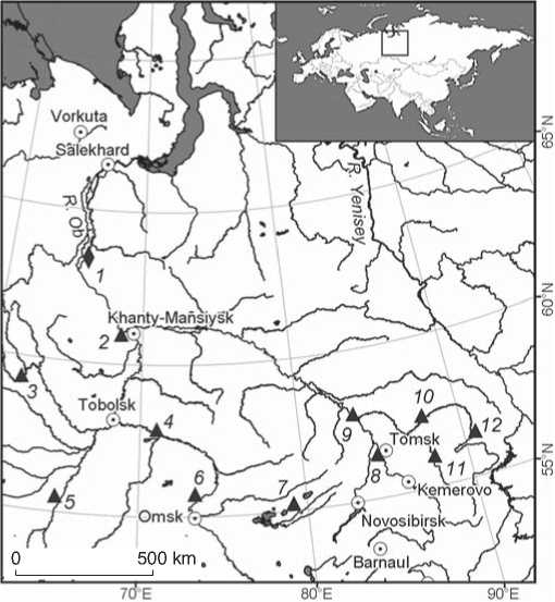
Fig. 1. Location of the Komudvany site and other main Paleolithic sites in the West Siberian Plain.
1 – Komudvany; 2 – Lugovskoye; 3 – Gary; 4 – Ust-Ishim; 5 – Shikaevka-2; 6 – Cherno-Ozerye-2; 7 – Volchya Griva; 8 – Tomskaya site; 9 – Mogochino; 10 – Krasnoyarskaya Kurya; 11 – Shestakovo; 12 – Achinskaya.
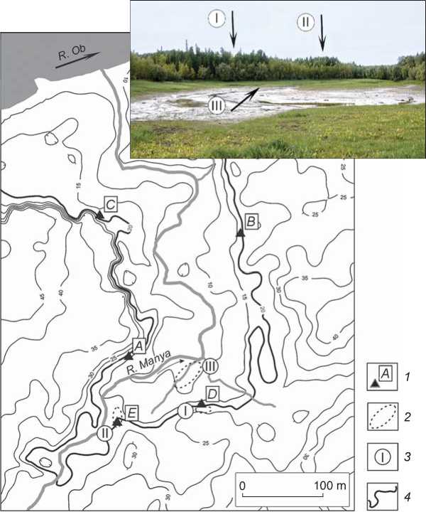
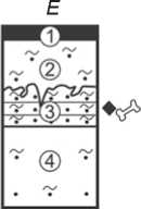
Fig. 2. Layout plan of the Komudvany site.
I – terrace area; II – promontory area; III – floodplain area.
1 – main profiles (see Fig. 3); 2 – site areas; 3 – site area numbers; 4 – the level of the coastal ledge of the terrace area.
and Man, the Institute of Archaeology and Ethnography SB RAS, Tomsk State University, and the Sobolev Institute of Geology and Mineralogy SB RAS (Makarov, Rezvyi, Gorelik, 2018).
The site contained three areas with archaeological finds: terrace, promontory, and floodplain (Fig. 2). The first two areas yielded lithic artifacts and faunal remains. The floodplain area didn’t contain lithic artifacts, but the paleontological collection included a mammoth-tusk spatula (or shaft) with signs of working. To date, the site includes a trench, a main excavation area, 11 test pits (excavated area totals 50 m2), and six profiles at the banks. The conducted field studies have shown three bone-bearing horizons on the terrace; the archaeological material is associated with the upper one.
Geological and geomorphological characteristics of the study area
The study area is located at the northwestern margin of the Belogorskaya Upland, which is composed mainly of Middle Quaternary glacial and water-glacial deposits overlain by the Upper Quaternary subaerial cover. The right bank of the Ob is steep and rises several tens of meters above the water edge. The mouth area of the Manya valley is located within the lower relief of the ancient bend of the paleo-Ob, which probably corresponds to fluvial terrace I, with the height of the edges of this elevated plain not exceeding 4–5 m above the low-water level in the Manya. This terrace adjoins elevated remnants resting on the Middle Quaternary base. Test profile 3 was established in a coastal cliff 10.2 m high above the edge of the towpath on the left bank of the Manya (Fig. 3, A), and produced the general idea of the stratigraphy. The modern soil, 0.1 m thick (layer 1), is underlain by a subaerial cover ~2.0 m thick composed of unstratified eolian sand (layer 2) and diluvium (layers 3, 4). Below is a dense diamicton (layer 5) containing sandy siltstone with rare ice blocks of boulder-pebble size, the visible thickness is ~2.0 m; this layer is the main Middle Pleistocene moraine.
Profile 2 was established on the right bank of the Manya, on a terrace 4 m high above the towpath (Fig. 3, B ). Here, under modern soil 0.1 m thick (layer 1), there is a subaerial cover 1.0 m thick (layer 2) represented by diluvium (alternating sand and silt sand). Small frost wedges were recorded in its bottom portion. Below, there are parallel-layered (layer 3) and crosslayered (layer 4) alluvial sands with pebbles of a total thickness of 2.1 m. Beneath the alluvium, diamicton was uncovered, comprising a non-layered sand-aleuropelite with rare boulder-pebble ice blocks and grus (layer 5)— the main mid-Quaternary moraine. The moraine is underlain by sands with a visible thickness of 0.55 m. At their contact, there is a gneissic texture ~0.2 m thick (glaciomelange), in the moraine itself there are rare small flat outliers of the underlying sand. This outcrop is remarkable in that the alluvial deposits are exposed above the Middle Pleistocene base of the profile, with the alluvium being most likely the subaquatic part of Ob’s fluvial terrace I, the height of which in this area is 4 m above the towpath edge. Profile 5 was established at
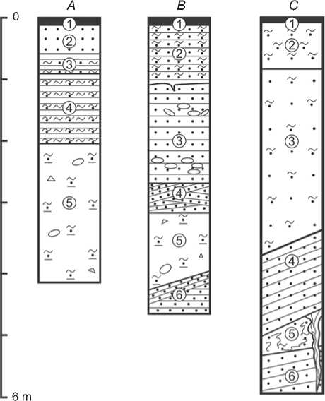
Fig. 3. Stratigraphic columns of the main profiles of the mouth area of the Manya.
A – test profile 3 ; B – test profile 2 ; C – test profile 5 ; D – excavation of 2021 ; E – test pit 5 .
1 – sand; 2 – silty sand; 3 – silt; 4 – sand-aleuropelite; 5 – grus and boulders; 6 – oblique bedding; 7 – gneissic textures; 8 – frost wedges;
9 – modern soil; 10 – megafaunal remains; 11 – lithic artifacts; 12 – numbers of layers.
D

this terrace at a height of ~5.0 m above the towpath on the left bank of the Manya (Fig. 3, C ). Modern soil 0.1 m thick (layer 1) was underlain by a subaerial cover 5.4 m thick comprising unstratified eolian sands and silty sands (layers 2 and 3), sandy deluvium layered parallel to the modern slope of the terrace surface (layer 4), and sandy soliflux (layer 5) with wedges from the top layer to a depth of up to 1.5 m. Below are parallel-layered alluvial sands with a visible thickness of up to 0.8 m.
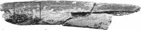
Deposits containing remains of megafauna and archaeological finds were uncovered on the right bank of the Manya, on the terrace area of the site. The excavation 2021 was laid in the central part of the site, 3 m from the terrace edge (Fig. 3, D; 4). The modern soil, 0.2 m thick (layer 1), was underlain by a subaerial cover 3.8 m thick containing the following stratigraphic layers: non-layered eolian silty sand (layer 2); diluvium (alternating sand and silt sand) layered parallel to the slope (layer 3); non-layered eolian sand ~0.2 m thick (layer 4), whose 0.1 m thick top portion was associated with the mammoth bones and lithic artifacts (upper bone-bearing level and culture-bearing layer); nonstratified eolian silty sand, sporadically saturated with silty fraction forming silty sand (layer 5) and containing reindeer remains in the middle part, at a depth of ~2.0 and 2.2 m (middle bone-bearing level); sandy patchy- banded soliflux (layer 6); and non-stratified eolian sand with rodent casts and rare small humus lenses (layer 7). The subaerial complex of sediments was underlain by lacustrine-marsh sediments (perhaps these are the sediments of a floodplain lake) of unstratified pale blue silty sand with rare small black spots of organic matter and a marsh smell (layer 8); the apparent thickness is up to 0.7 m. The contact between these two layers is uneven and deformed by solifluction. Faunal remains were found 0.4 m from the top of layer 8 (lower bonebearing level) (Makarov, Rezvyi, Gorelik, 2018).
On the promontory area of the site, at a height of ~2.0 m above the towpath, test pit 5 was established. It revealed a bone-bearing level with archaeological finds (see Fig. 3, E ). Under the modern soil 0.15 m thick (layer 1), there is a subaerial cover 1.8 m thick containing non-layered eolian silt sand (layer 2), and diluvium (alternating sand and silt sand) layered parallel to the slope (layer 3), with wedges and solifluction deformations in its top part. This last layer yielded lithic artifacts and paleofaunal remains. Further below, there is a layer of unstratified aeolian silty sand and silt sand in some places (layer 4).
The daylight surface of the terrace and promontory sections does not form a flat area elevated to a common hypsometric level. It is gently segmented by stream and deluvial erosion, and possibly by deflationary processes.
The greater thickness of the diluvium at the promontory area (see Fig. 3, E , layer 3) as compared to the terrace area (see Fig. 3, D , layer 3) and the absence in the promontory area of a clearly expressed layer of unstratified aeolian sand recorded in the terrace area (see Fig. 3, D , layer 4), as well as the discovery of archaeological and paleontological materials in these layers, suggest the influence of local planar erosion of the eolian layer by deluvial processes on the formation of layer 3 in the promontory area. Thus, the finds from layer 3 of trench 5 and from layer 4 of the 2021 excavation are probably of the same age.
The upper bone-bearing level (layer 4) was studied in the terraced area over 12 m2 (trench, excavation and pits) and in two test profiles; the middle bone-bearing level (layer 5) was studied over an area of 2 m2 in the excavation of 2021; the lower one (layer 8) over 1 m2 in test profile 1. In the promontory area, the bone-bearing level lying in sediments of subaerial genesis, with signs of diluvial transport (layer 3), was studied over an area of 2 m2.
The two upper bone-bearing levels, the upper of which contains lithic artifacts, are associated with the subaerial cover with a total thickness of up to 3.8 m. This cover, in all likelihood, was formed when the Ob’s alluvial terrace I emerged into a floodplain position, approximately 15 thousand years ago. Lacustrine-marsh blue silts at the base of the terrace area may be coastal deposits on the drained floodplain, completing the formation of the alluvial stage of this terrace. This interpretation is not contradicted by radiocarbon dates (~20,000 cal BP) generated on bones from layer 8 (see Table ). Below, deposits of the Middle Quaternary glaciocomplex occur, which are typical for the northwestern margin of the Belogorskaya Upland in the lower reaches of the Ob. The height of fluvial terrace I ranges from 3 to 7 m above the low-water level in the Ob, which is due to the different thickness of the subaerial cover in its various parts, as well as to the uneven erosional (stream) and planar (diluvial and deflationary) denudation.
Paleontological finds
The remains of large mammals are distributed over the entire surface of the mouth area of the Manya floodplain. The highest concentration was recorded on the right bank of a small stream flowing into the Manya River (floodplain area) (see Fig. 2). In the surface collections, mammoth remains ( Mammuthus primigenius Blum.) predominate ( n =567, which is 97.7 % of all identifiable finds (≥13 individuals)). Bones
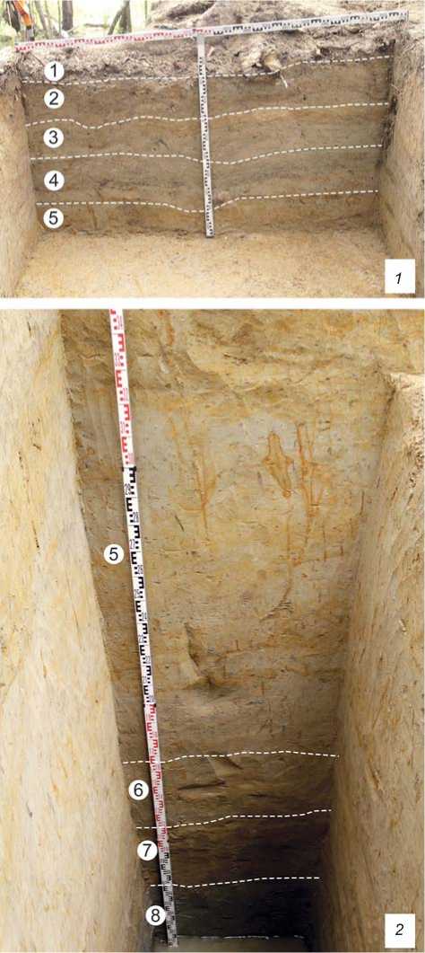
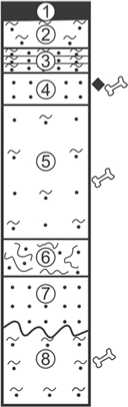
Fig. 4. The northwestern wall in the excavation of 2021.
1 – upper part; 2 – lower part. Geological layers are marked with figures.
of woolly rhinoceros ( Coelodonta antiquitatis Blum.), reindeer ( Rangifer tarandus L.), horse ( Equus sp.), and bison ( Bison sp.) were also found. These finds are a mixed complex, which is confirmed by the great range of the radiocarbon dates obtained as compared to other parts of the site (see Table ).
Paleontological materials from the upper bonebearing level (layer 4) in the terrace area include
Results of dating of the fossil faunal remains
|
Place of deposition |
Taxon |
Method |
Radiocarbon date, BP |
Calendar age, BP |
Lab code |
|
Lower bone-bearing |
Mammal |
AMS |
17,060 ± 90 |
20,853–20,420 |
NUTA2-25794 |
|
level (layer 8) |
ʺ |
17,040 ± 60 |
20,795–20,444 |
NUTA2-25451 |
|
|
ʺ |
ʺ |
16,810 ± 40 |
20,468–20,020 |
UGAMS-40953 |
|
|
Upper bone-bearing |
Woolly mammoth |
14 С |
12,567±150 |
15,331–14,117 |
SPb-2672 |
|
level (layer 4) |
ʺ |
AMS |
12,320 ± 35 |
14,809–14,104 |
UGAMS-40954 |
|
Floodplain area (surface |
Woolly rhinoceros |
ʺ |
14,750 ± 50 |
18,222–17,907 |
NUTA2-25450 |
|
collections) |
ʺ |
14,540 ± 90 |
18,089–17,415 |
NUTA2-25793 |
|
|
Reindeer |
14 С |
12,243 ± 120 |
14,847–13,810 |
SPb-2673 |
|
|
Woolly mammoth |
ʺ |
10,622 ± 110 |
12,765–12,103 |
SPb-2298 |
|
|
ʺ |
ʺ |
10,565 ± 100 |
12,740–12,102 |
SPb-2297 |
155 specimens. All identifiable bones were attributed to mammoth (≥3 individuals). In the anatomical composition of the finds, there are no skull bones; the vertebrae are represented only by fragments of neural arches (2.6 %); there are also epiphyses of bones of the anterior (4.5 %) and hind (7.7 %) limbs, fragments of ribs (37.7 %), phalanges (5.2 %) and small unidentifiable bone fragments (42.3 %).
Paleontological materials from the middle bonebearing level (layer 5) in the terrace area are represented by fragments of tubular reindeer bones (5 spec.). The finds were collected over an area of 0.2 × 0.2 m, which may indicate that they belonged to one individual. The surfaces of the bones are covered with traces of plantroots. Within the lower bone-bearing level (layer 8), in the area of the same size, fragments of the mammal’s ribs (3 spec.) were recorded; the ribs were tentatively assigned to one individual. The bones are dark brown, resembling the state of preservation of the bones from the surface collections.
Paleontological materials from the promontory area (11 spec.) form a single bone-bearing level (layer 3). The poor preservation of the bones, which may be due to redeposition, did not allow for species identification.
Results of the radiocarbon dating
In total, ten radiocarbon dates were generated on the bones from surface collections in the floodplain area and from the upper and lower bone-bearing levels of the terrace area (see Table)*. Calendar age was determined using the OxCal, v. 4.4.4., according to the IntCal20 calibration curve (Muscheler et al., 2020), with a reliability of 95.4 %.
The dates of the bones from the floodplain show a wide range (~18–12 cal ka BP) in comparison with samples from the upper (~15–14 cal ka BP) or lower (~21–20 cal ka BP) bone-bearing levels. Thereby, the paleontological segment of the Komudvany site was formed in the interval from ~21 to 12 cal ka BP, and the presence of Paleolithic man in this place can be associated with a single habitation stage, during the formation of the upper bone-bearing level, ~15–14 cal ka BP.
Lithic artifacts
Lithic artifacts were recorded in situ in the upper bonebearing level (layer 4) in three test pits, trench, and excavation area (terrace and promontory areas). Washing and sieving the deposits of the floodplain area did not reveal any lithics, although paleontological material was found. At present, all the lithic artifacts (28 spec.) are assigned to the single complex, and include a laminar flake, flakes (9 spec.), shatters (17 spec.), and a chip. No core-like forms have been found. The tool collection (5 spec.) included a retouched flake (point ?), flakes, and a shatter with traces of utilization retouch (Fig. 5).
The following raw materials of the lithic artifacts were identified visually: quartz/quartzite – 71.5 % (20 spec.), sandstone – 25.0 % (7 spec.), agate (?) – 3.5 % (1 spec.). Four flakes and the chip retained pebble crust over some parts of the surface. Most likely, the source of raw material were pebbles >5 cm in size from perluvium deposits of the Middle Quaternary moraines in the immediate vicinity of the site.
The parallel flaking was the most characteristic technique of primary knapping; however, one spall shows bidirectional flaking of the edges of the dorsal surface. All the spalls are small, not more than 5 cm long. The striking platforms are plain and straight (one punctiform platform was noted), prepared through one removal. One flake shows the use of the overhang rejuvenation technique.
Noteworthy is the flake with convergent lateral sides, one of which, in its distal part, was additionally fashioned with marginal dorsal retouch (Fig. 5, 4 ). This artifact can be interpreted as a small pointed form. The distal end of the bladelet flake bears small notches, which can be considered as utilization retouch (Fig. 5, 3 ). A similar retouch was noted on the laterals of two more flakes (Fig. 5, 1 , 2 ) and on a shatter (Fig. 5, 5 ).
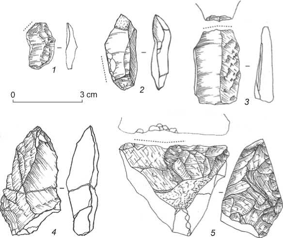
Fig. 5. Lithic artifacts from terrace area (layer 4).
1–3 – flakes with utilization retouch; 4 – retouched flake (point ?); 5 – shutter with utilization retouch.
Artifacts of mammoth tusk
A fragment of mammoth tusk (29.2 × 6.1 to 5.1 × × 5.0 cm), bearing traces of longitudinal splitting (“breaking” in G.A. Khlopachev’s and E.Y. Giria’s terminology (2010: 29)), was found in situ in layer 4 in the terrace area. Its surface shows a partially preserved cement layer, negative scars of longitudinal flaking, and a zone of severely cracked dentin. The ends of the tusk fragment are broken off. The cement layer is associated with two planes of longitudinal splitting, which are oriented tangentially to the structure of the tusk and extend over the entire length of the fragment. The negative scars partially overlap one another, indicating the sequence of operations. The rest of the tusk’s surface shows growth cones delaminated and cracked to various depths. This fragment can be interpreted as a core for producing tusk rods or blades (Pitulko, Pavlova, Nikolsky, 2015).
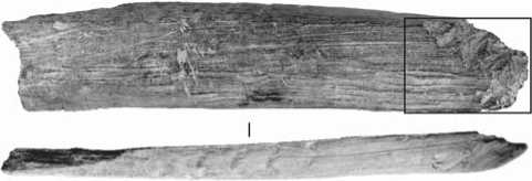
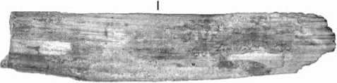
A spatula (or shaft) made from a mammoth tusk (80.7 × 17.6 × 5.0 mm) (Fig. 6, 1) was collected from the floodplain. It is rectangular in shape, with a slightly concave ventral surface, a curved dorsal surface, and a slightly twisted (propeller-like) profile. One end was truncated; the opposite end had been sharpened with several cuts. The concave surface of the blade is natural, with traces of stratification of dentin, while the convex surface bears numerous long, shallow, and subparallel scratches. One lateral side is pointed, the other is flatter and resembles an artificially fashioned back. The back shows six parallel notches located at approximately the same distance from each other.
Discussion
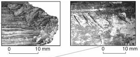
Komudvany occupies almost the entire mouth area of the Manya River, but the bones are concentrated mainly in the floodplain along the right bank, in the immediate vicinity of the terrace area. The proximity of the upper bone-bearing level to the edge of the terrace-like ledge, as well as a significant number of paleontological finds in the adjacent floodplain area, suggest the destruction of a greater part of the original site as a result of erosion. Distinctions revealed in the anatomical composition of paleontological surface collections and those deposited in situ may indicate also the anthropogenic factor in the formation of the upper bone-bearing level. The predominance of bones with a low nutritional value index (distal parts of the limbs and ribs) (Kasparov, Nekhoroshev, 2018) allows us to consider the studied part of the upper bone-bearing layer as a possible butchering zone. Several subparallel cut marks noted on the rib (Fig. 6, 2 ), as well as the in situ co-occurrence of stone flakes and faunal remains, support this assumption.
5 cm
Fig. 6. Faunal remains with traces of anthropogenic impact.
1 – bladelet of mammoth tusk (floodplain area, surface collection); 2 – rib-fragment with cut marks (terrace area, layer 4).
Lithic artifacts are not numerous at the site; the collection does not contain cores; formal tools are extremely rare. Spalls are represented exclusively by flakes, one of which is bladed. Four specimens have traces of use-wear retouch, suggesting their use as situational tools. All the spalls are <5 cm in length, which can be explained by the rarity of high-quality raw materials in the area of the site and by the use of small pebbles of quartz and quartzite from the Ob towpath in the immediate vicinity of the site, which are unsuitable for knapping.
Fragments of mammoth tusks from Komudvany, with traces of working, are common finds for many Late Paleolithic sites (Anikovich, 1992; Khlopachev, Girya, 2010: 7; Pitulko, Pavlova, Nikolsky, 2015), including the sites in the West Siberian Plain (Petrin, 1986: 102–109; Derevianko et al., 2003: 132–136; Seuru et al., 2017). Solitary tools, the presence of a series of spalls with utilization retouch and the small size of the artifacts, along with the association to the mammoth fauna, make the Komudvany complex close to the majority of Paleolithic sites in Western Siberia: Lugovskoye, Gary, Shikaevka-2, Volchya Griva, Shestakovo, Krasnoyarskaya Kurya, the Tomskaya site, etc. (Kashchenko, 1901: 28–30; Petrin, 1986: 21–99; Derevianko et al., 2000; Zenin et al., 2006; Serikov, 2007: 96–106; Seuru et al., 2017; Leshchinskiy, Zenin, Bukharova, 2021); however, a more accurate attribution of finds is still difficult.
Conclusions
The Komudvany site is situated at the megafaunal locality dominated by the mammoth remains. The excavations have shown that the deposits in the terrace area (probably, fluvial terrace I) began to accumulate prior to 20 cal ka BP, and ~14 cal ka BP the sedimentation was subaerial. Radiocarbon dating of fossil faunal remains indicates the formation of a paleontological locality during several thousand years.
The site includes three areas: the terrace area yielding three levels of in situ occurrence of bones, with lithic artifacts in the upper level; the promontory area yielding one bone-bearing level with archaeological finds; and the floodplain area with the surface occurrence of paleontological and archaeological materials. Eolian, deluvial, and erosional processes had an effect on the formation of deposits containing archaeological finds.
The available data suggest at least one episode of human habitation between 15 and 14 cal ka BP. The people were likely attracted by a large number of faunal remains providing local, easily accessible supply. Animal bones and tusks could have been an additional valuable resource used in production of tools or nonutilitarian items. The composition of the bones and cut marks on their surfaces, as well as lithic artifacts, indicate the anthropogenic factor in the formation of the upper bone-bearing level, which allows us to interpret the Komudvany site tentatively as a temporary camp associated with the mammoth faunal locality, where bone and tusk raw materials could be collected and animal carcasses could be butchered.
Though the collection of lithic artifacts was small, the site is important. It is the northernmost archaeological site of the terminal Late Paleolithic in the West Siberian Plain. A representative series of radiocarbon dates and in situ occurrences of archaeological and paleontological materials make it possible to consider Komudvany, along with the
Lugovskoye site, as a reference object for studying the processes of early human habitation in the northern regions of Asia.
Acknowledgements
The study was supported by the Russian Science Foundation (Project No. 19-78-20002). Special thanks go to the participants of the research at the Komudvany site and especially to S.N. Telegina, a Chief Researcher at the Paleontological Department of the Museum of Nature and Man, for her assistance in the organization of the field studies.
References Komudvany—a Final Paleolithic Site in the Lower Ob Valley: Geomorphology, Paleontology, Archaeology
- Anikovich M.V. 1992 K opredeleniyu ponyatiya “arkheologicheskaya epokha”. Sovetskaya arkheologiya, No. 1: 85-94.
- Arkhipov S.A., Volkova V.S. 1994 Geologicheskaya istoriya, landshafty i klimat pleistotsena Zapadnoy Sibiri. Novosibirsk: OIGGM SO RAN.
- Astakhov V.I., Nazarov D.V. 2010 Stratigrafi ya verkhnego neopleistotsena severa Zapadnoy Sibiri i eye geokhronometricheskoye obosnovaniye. Regionalnaya geologiya i metallogeniya, No. 43: 35-37.
- Derevianko A.P., Molodin V.I., Zenin V.N., Leshchinskiy S.V., Mashchenko E.N. 2003 Pozdnepaleoliticheskoye mestonakhozhdeniye Shestakovo. Novosibirsk: Izd. IAET SO RAN.
- Derevianko A.P., Zenin V.N., Leshchinskiy S.V., Mashchenko E.N. 2000 Peculiarities of mammoth accumulation at Shestakovo site in West Siberia. Archaeology, Ethnology and Anthropology of Eurasia, No. 3: 42-55.
- Fu Q., Li H., Moorjani P., Jay F., Slepchenko S.M., Bondarev A.A., Johnson P.L.F., Aximu-Petri A., Prüfer K., De Filippo C., Meyer M., Zwyns N., Salazar-García D.C., Kuzmin Y.V., Keates S.G., Kosintsev P.A., Razhev D.I., Richards M.P., Peristov N.V., Lachmann M., Douka K., Higham T.F.G., Slatkin M., Hublin J.-J., Reich D., Kelso J., Viola B., Pääbo S. 2014 Genome sequence of a 45,000-year-old modern human from Western Siberia. Nature, vol. 514: 445-450.
- Kashchenko N.F. 1901 Skelet mamonta so sledami upotrebleniya nekotorykh chastey tela etogo zhivotnogo v pishchu sovremennym emu chelovekom. St. Petersburg: [Tip. Imp. Akad. nauk]. (Zap. Imp. Akademii nauk po fi z.-mat. otd-niyu; vol. XI, No. 7).
- Kasparov A.K., Nekhoroshev P.E. 2018 K voprosu o vozraste i tipe verkhnepaleoliticheskikh pamyatnikov Beryozovskiy razrez 1 i 2. Zapiski IIMK RAN, No. 19: 20-35.
- Khlopachev G.A., Girya E.Y. 2010 Sekrety drevnikh kostorezov Vostochnoy Yevropy i Sibiri: Priyemy obrabotki bivnya mamonta i roga severnogo olenya v kamennom veke (po arkheologicheskim i eksperimentalnym dannym). St. Petersburg: Nauka.
- Leshchinskiy S.V., Zenin V.N., Bukharova O.V. 2021 The Volchia Griva mammoth site as a key area for geoarchaeological research of human movements in the Late Paleolithic of the West Siberian Plain. Quaternary International, vol. 587/588: 368-383.
- Makarov S.S., Rezvyi A.S., Gorelik V.I. 2018 Mestonakhozhdeniye Komudvany - noviy paleontologoarkheologicheskiy pamyatnik Zapadno-Sibirskoy ravniny. In Evolyutsiya zhizni na zemle: Materialy V Mezhdunar. symp., 12-15 November 2018 g. Tomsk: Izd. Tom. Gos. Univ., pp. 215-217.
- Muscheler R., Adolphi F., Heaton T.J., Ramsey C.B., Svensson A., Plicht J., van der, Reimer P.J. 2020 Testing and improving the IntCal20 calibration curve with independent records. Radiocarbon, vol. 62 (4): 1079-1094.
- Pavlov A.F., Mashchenko E.N. 2001 Osobennosti tafonomii i sostava fauny mlekopitayushchikh pozdnepleistotsenovogo mestonakhozhdeniya Lugovskoye. In Evolyutsiya zhizni na Zemle: Materialy II Mezhdunar. simp., 12-15 noyab. 2001 g. Tomsk: Izd. nauch.-tekhn. lit., pp. 522-524.
- Pavlov P.Y. 2016 O pervonachalnom zaselenii severa Urala. Uralskiy istoricheskiy vestnik, No. 2: 50-60.
- Petrin V.T. 1986 Paleoliticheskiye pamyatniki Zapadno-Sibirskoy ravniny. Novosibirsk: Nauka.
- Pitulko V.V. 2016 Svidetelstva rannego rasseleniya cheloveka v Arkticheskoy oblasti Yevrazii: Noviye nakhodki i perspektivy issledovaniy. In Arkheologia Arktiki, iss. 3. Kaliningrad: ROS-DOAFK, pp. 91-116.
- Pitulko V.V., Nikolskiy P.A., Girya E.Y., Basilyan A.E., Tumskoy V.E., Koulakov S.A., Astakhov S.N., Pavlova E.Y., Anisimov M.A. 2004 The Yana RHS site: Humans in the Arctic before the last glaciation. Science, vol. 303: 52-56.
- Pitulko V.V., Pavlova E.Y., Nikolsky P.A. 2015 Obrabotka bivnya mamonta v verkhnem paleolite Arkticheskoy Sibiri (po materialam Yanskoy stoyanki). Stratum Plus, No. 1: 223-283.
- Serikov Y.B. 2007 Garinskaya paleoliticheskaya stoyanka i nekotoriye voprosy uralskogo paleolitovedeniya. Nizhniy Tagil: Izd. Nizhnetagil. Gos. Sots.-Ped. Akademii. Seuru S., Leshchinskiy S., Auguste P., Fedyaev N. 2017 Woolly mammoth and man at Krasnoyarskaya kurya site, West Siberian plain, Russia (excavation results of 2014). Bulletin de la Société Géologique de France, vol. 188 (1/2):1-13.
- Svendsen J.I., Alexanderson H., Astakhov V.I., Demidov I., Dowdeswell J.A., Funder S., Gataullin V., Henriksena M., Hjorti C., Houmark-Nielsenj M., Hubberten H.W., Ingolfsson O., Jakobsson M., Kjaer K.H., Larsen E., Lokrantz H., Lunkka J.P., Lys A., Mangerud J., Matiouchkov A., Murrayr A., Moller P., Niessen F., Nikolskaya O., Polyak L., Saarnisto M., Siegert C., Siegert M.J., Spielhagen R.F., Stein R. 2004 Late Quaternary ice sheet history of Northern Eurasia. Quaternary Science Reviews, vol. 23: 1229-1271.
- Svendsen J.I., Pavlov P. 2003 Mamontovaya Kurya: An enigmatic, nearly 40 000 years old Paleolithic site in the Russian Arctic. In The Chronology of the Aurignacian and of the Transitional Technocomplexes: Dating, Stratigraphies, Cultural Implications: proceedings of Symposium 6.1 of the XIVth Congress of the UISPP (University of Liege, Belgium, September 2-8, 2001). Lisboa: Instituto Português de Arqueologia, pp. 109-120.
- Velichko A.A., Vasiliev S.A., Gribchenko Y.N., Kurenkova E.I. 2014 Etapy pervichnogo osvoyeniya chelovekom Arktiki i Subarktiki. In Pervonachalnoye zaseleniye Arktiki chelovekom v usloviyakh menyayushcheisya prirodnoy sredy. Moscow: Geos, pp. 422-446.
- Zenin V.N., Leshchinskiy S.V., Zolotarev K.V., Grootes P.M., Nadeau M.-J. 2006 Lugovskoe: Geoarcheology and culture of a Paleolithic site. Archaeology, Ethnology and Anthropology of Eurasia, vol. 25 (1): 41-53.
- Zolnikov I.D., Anoikin A.A., Filatov E.A., Vybornov A.V., Vasiliev A.V., Postnov A.V., Zotkina L.V. 2021 New evidence of the Late Neopleistocene peopling of the Lower Ob Valley. Archaeology, Ethnology and Anthropology of Eurasia, vol. 49 (1): 9-20.
- Zolnikov I.D., Anoikin A.A., Makarov S.S., Postnov A.V., Rezvyi A.S., Glushkova N.V., Bychkov D.A., Tupakhin D.S., Vybornov A.V. 2020 O vozmozhnykh putyakh migratsii cheloveka na territoriyu Nizhnego Priobya v kamennom veke. Stratum Plus, No. 1:137-146.
