Location of Tatar settlements in the Middle and Lower Tara region according to 18th century maps

Author: Tikhomirov K.N., Tikhomirova M.N.
Journal: Archaeology, Ethnology & Anthropology of Eurasia @journal-aeae-en
Section: Ethnology
Article in issue: 3 т.49, 2021.
Free access
Тhis article discusses the location of Tatar settlements in the lower and middle reaches of the Tara on maps of the Tarsky Uyezd (1784 and 1798) and on topographic plan of the Kartashevskago and Bergamotskaya districts of the Tarsky Uyezd (1798). These maps had not been previously used for reconstructing the history of the region. To test their accuracy, other sources are used, including the Inventory Book of the Tarsky Uyezd, Gerhard Miller’s itineraries, etc., as well as the results of archaeological and ethnographic studies. Based on the analysis of maps, patterns in the locations of Tatar settlements are reconstructed. They were situated between the mouth of Tara and its confl uence with the Chertalinka River on the right bank, and between the Chertalinka and Kalinka rivers on the left bank. The reliability of the late 18th century maps as sources of information about the winter and summer settlements of the Tatars of the Middle and Lower Tara is assessed. These maps do not suggest that the settlements were still seasonal rather than permanent at that time. The winter camps were situated on the Tara high terrace, away from the valley, and summer camps were on the fl ood plain, close to the villages. The general pattern was that people settled along the river, often close to the places where the Tara tributaries fl owed into it. Place names are suggestive of seasonal settlements. Comparison with modern maps suggests that the current settlements pattern on the Lower and Middle Tara emerged in the late 18th century.
Western Siberia, Middle and Lower Tara, 18th century maps, Tatar settlements, ethnography, archaeology
Short address: https://sciup.org/145146302
IDR: 145146302 | DOI: 10.17746/1563-0110.2021.49.3.093-100
Text of the article Location of Tatar settlements in the Middle and Lower Tara region according to 18th century maps
This work is devoted to the analysis and comparison of cartographic materials of the 18th century that were not previously used in the research associated with the locations of the Tatars’ settlements. Nowadays, there is a significant bias in the study of the early history of the Tatars and their ancestors who lived in the territory of the Omsk Region. Almost all the studied archaeological complexes that are associated with the Tatar population of the Middle Irtysh region are located on the Tara River. They belong to the 16th–18th centuries—the beginning of the formation of the modern cultural appearance of the Tatars. The rest of the territory of their settlement remains unexplored. Notably, the largest part of the sites that have been studied are flat-grave burial grounds. Thus, we have only a onesided knowledge of the cultural history of this population. The settlements of the Tatars, and the huge layer of culture associated with them, remain practically unknown. The main reason for this situation is the difficulty of detecting and researching such objects. This is due, for the most part, to the lack of cartographic materials in circulation.
The sources for the study of the early history of the Tatars living on the banks of the Tara River were the maps of the territory of the Tarsky Uyezd from 1780, 1784, and 1798, which contain information about the
location of Russian and Tatar villages. These documents, differing in the degree of reliability, are not as accurate nor as informatively rich as modern maps. Nevertheless, they make it possible to obtain new information about the places of Tatar settlements, hydronyms, the locations of watermills, the boundaries of districts, etc.
The present study concerns the extant abandoned settlements located on the banks of the Tara River, in the area including the mouth (Tarsky District), the middle course of the river (Muromtsevsky District of the Omsk Region), and the village of Almenevo on the border of the middle and upper reaches of the Tara (Kyshtovsky District, Novosibirsk Region). The choice for the study of this zone was determined by the fact that, according to the documents of the 17th–18th centuries, it was the territory of the Ayalynskaya Volost (district), compactly inhabited by a group of Tatars. As a result of many years of research by ethnographers and archaeologists, a large source base was formed on the history of the population of this region in the 17th–20th centuries (Korusenko M.A., Zdor, Gerasimov, 2015; Korusenko S.N., 2006; Titov, 2007; Tomilov, 1996; Etnografo-arkheologicheskiye kompleksy…, 2014, 2016; and others).
This study was based on previously unused published and unpublished cartographic materials of the 18th century: “Map of the Tarsky Uyezd… 1784” (hereafter—Map of 1784) (Karta Tarskogo uyezda…, 1784) from the “Geographic Atlas of the Tobolsk Vicegerency”, “Map of the Tarsky Uyezd… 1798” (hereafter—Map of 1798) on a scale of 1 inch : 15 versts *, and the “Topographic Plan of the Kartashevskago Village (on River Irtysh) District and Bergamotskaya Sloboda (on the Tara River, without the mouth area) District of the Tarsky Uyezd” (hereafter—Topographic Plan of 1798) on a scale of 1 inch : 3 versts from the “Atlas of the Tobolsk Governorate” (Atlas…, 1798; Konovalova, Popov, 2010). The Topographic Plan of 1798 contains information on the exact location of Tatar settlements along the Tara, from the Bergamotskaya yurts to the Almenevo yurts, as well as the number of lands (and their types) allocated to each settlement, the names of small rivers and lakes. It should be noted that some data on the Map and the Topographic Plan of 1798, compiled by land surveyor Vasily Filimonov, diverge. The main sources also include the map “Tabula Exhibens Cursum…” (hereafter— Map of 1780), created in 1780 by I.I. Islenyev (Tabula Exhibens Cursum…, 1780)**.
Additional sources were used for the analysis: the “Drafting Book Compiled by the Tobolsk Boyar’s Son Semyon Remezov in 1701” (hereafter—Drafting Book) (Chertezhnaya kniga…, 1701), the “Chorographic
Drafting Book of Siberia by S.U. Remezov” (hereafter— Chorographic Drafting Book) (Khorograficheskaya chertezhnaya kniga…, 2011), the “Inventory Book of the Tarsky Uyezd of 1701” (hereafter—Inventory Book of 1701), published in part in the monograph by S.N. Korusenko (2006), and records by G.F. Miller (Sibir XVIII veka…, 1996). Unfortunately, these sources do not indicate the exact location of the settlements.
When conducting a study, cartographic materials of the 18th century were compared to the modern maps. For this, the atlas of the Omsk Region 1 : 100,000 (Omskaya oblast, 2010) and satellite images posted on the open Internet resource Bestmaps (Bestmaps, (s.a.)) were used.
The information recorded in the indicated sources was corrected during the expeditions. One of the authors examined a large number of settlement sites and cemeteries of the Tara Tatars, took photographs of the objects, performed preliminary excavation of the cultural layer and surface collection, and created site plans. This made it possible to make new assumptions about the specific location of the settlements.
The names of the settlements in the above-mentioned cartographic materials of the 18th century differ; therefore, in the illustrations and in the text the names are given indicated in the sources.
The history of mapping the region in the 18th century, archaeological and ethnographic research of the Tatars settlements
For the first time, the settlements of the Tatars in the Middle and Lower Tara region in the 18th century were recorded on the maps of the Chorographic Book created in 1697–1711 (Khorograficheskaya chertezhnaya kniga…, 2011: 93), and of the Drafting Book compiled in 1699–1701 (Chertezhnaya kniga…, 1701). These are valuable resources on the topic at hand, but should not be idealized, as they are full of inaccuracies; in some places, they contradict each other and later cartographic materials. For example, the maps of the area of interest to us, on fol. 93 and on the insert on fol. 93, are more reminiscent of very rough schemes, and the data on them differ. Unfortunately, the settlements are marked on them without precision. These are tied only to rivers locations (Khorograficheskaya chertezhnaya kniga…, 2011: Fol. 93, ins. on fol. 93; Chertezhnaya kniga…, 1701).
Twenty-three years after the completion of works on the production of the “Chorographic Drafting Book of Siberia”, G.F. Miller wrote travel notes that significantly clarified and supplemented the Chorographic Book’s data. These indicate not only the geographical objects located near the settlement (lake, etc.), but also the distance between them in versts (Sibir XVIII veka…, 1996: 92–93).
In 1768, I.I. Islenyev made an instrumental-mathematical determination of the coordinates of Siberian towns, and in 1780, he made a map of the Irtysh River in the section from Omsk to Tobolsk, which includes the territory of interest in our study (Gnucheva, 1946: 250; Tabula Exhibens Cursum…, 1780).
In 1782, instead of the Siberian Governorate, the Tobolsk Vicegerency was formed, with the Tobolsk and Tomsk regions; therefore, in 1784, the “Geographical Atlas of the Tobolsk Vicegerency, Consisting of XVI Uyezds” was created. The administrative reform of 1796 led to the formation of a Tobolsk Governorate. This required new cartographic work. As a result, the “Topographic Atlas of the Tobolsk Governorate” was developed (Konovalova, Popov, 2010: 126).
Atlases of the late 18th century include the first detailed, professionally compiled maps, which reliably reflect the location of the Tara Tatars’ settlements.
Targeted search for the locations of the Tara Tatars settlements were not carried out until the end of the 20th century. The most significant contribution to the study of the Tatars’ settlements on Tara was made by S.N. Korusenko, N.A. Tomilov, and E.V. Titov. Their research was based on documents from archives, materials from ethnographic expeditions, published results of scientific research, official statistics, and local history works (Tomilov, 1981, 1996, 2011; Korusenko S.N., 2006; Korusenko S.N., Tomilov, 2011; Korusenko M.A., Korusenko S.N., 2019). However, the works of these researchers contain no data on locations of settlements; an exception is the article by M.A. Korusenko and S.N. Korusenko that reflects an attempt to identify the location of the village of Guzenevo in the past (2019).
The question of the location of the settlements of the Tara Tatars was researched by S.S. Tikhonov (2004, 2009). His research was based on the fragments of the Drafting Book and the Chorographic Drafting Book by S.U. Remezov, diary entries of G.F. Miller, and materials of archaeological excavations. Some of his conclusions are not sufficiently substantiated.
The locations of Tatars settlements in the Middle and Lower Tara in the 18th century
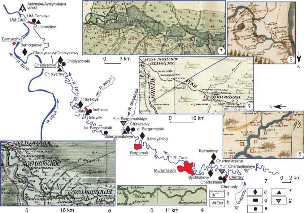
At the mouth of the Tara, the Inventory Book indicates “the village of Ust-Tarskaya (aka Tartamak)” (Korusenko S.N., 2006: 114). The Chorographic Drafting Book in this area also indicates the Ust Tarska / Usttarskaya (Khorograficheskaya chertezhnaya kniga…, 2011: Fol. ins. on fol. 93) (Fig. 1, 2, 5). According to G.F. Miller, there was “Tar-tamak-aul or the village of Ust-Tarskaya” here, with a mixed population: “Inhabited partly by Russians, partly by Yasak Tatars” (Sibir XVIII veka…, 1996: 92). The same was reported in 1772 by J.P. Falk (1824: 384–385). At present, the village of Ust-Tara is located in this place (Fig. 1, 7). On the Map of 1784, the Russian village Ust Tarskoye is marked on the right bank, and next to it (above) Tatar settlements “Ust Tarskiye”. It should be noted that it is here that the sign of the district with the inscription “Aelynska volost” stands (Fig. 1, 3). On the Map of 1798, the villages of Ustarskoye and Ustarskiye are recorded to be in the same locations. It also bears the sign of the district with the inscription “Ayalynskaya” (Fig. 1, 6). The western border of the Ayaly district was probably here. Its eastern border ran along the corresponding border of the Tarsky Uyezd. The territory of the next district located on the Tara, Tunuyska (judging by the corresponding sign), began at the Tatar settlement Chokovski (modern Chekiaul? – Author). On the Map of 1798, the border of the Tunuyska district is marked in the same location. Materials of the burial ground of the Tatar ancestors of the 17th–18th centuries discovered in the village of Ust-Tara (Tikhomirov, 2016: 115) point to the fact that Tatars had already been established in this area during the indicated period.
In the Drafting Book, upstream of the Tara, on its right bank, opposite the lake Beloye, a Tatar settlement is indicated (Chertezhnaya kniga…, 1701). According to the Chorographic Drafting Book, in this place, the Chaplyasovy (Khorograficheskaya chertezhnaya kniga…, 2011: Fol. 93) (Fig. 1, 5 ) / Cheplyakovy (Ibid.: Ins. on fol. 93) (Fig. 1, 2 ) was located. In the Inventory Book, there is a mention of the location of the “village of Chiplyarovy yurts” in this area (Korusenko S.N., 2006: 119). G.F. Miller recorded Tschupljar-aul on the right bank of the Irtysh, “2 versts distance from Loginov village”. The researcher noted that this was a former summer village, “winter dwellings… under the same name are located on the Tara River, 10 versts from… the river’s mouth. But a few years ago, they (Yasak Tatars. – Author ) also built summer dwellings opposite the winter village (modern Cheplyarovo village. – Author ), and left this older place” (Sibir XVIII veka…, 1996: 93). On the Map of 1784, on the right bank of the Tara, in this area, the Chiplyarovski are marked (Fig. 1, 3 ). On the Map of 1798, opposite this place, on the left bank of the Tara, the Chiplyarovy is indicated (Fig. 1, 6 ). At present, the village of Cheplyarovo is located on the low left bank of the river (Fig. 1, 7) , but, according to local residents, earlier it was located opposite—on the high right bank. In the same place, archaeologists have discovered a flat-grave burial ground of the 17th–18th centuries, Cheplyarovo XXVII (Korusenko M.A., 2013), and the contemporaneous settlement of Cheplyarovo XXVIII (Arkheologicheskaya karta…, 2000: 86).
In the Chorographic Drafting Book, on the right bank of the Tara, below the mouth of the Intsis River, the Intsis yurts are indicated (Khorograficheskaya chertezhnaya kniga…, 2011: Fol. 93, ins. on fol. 93) (Fig. 1, 2 , 5) . The
Ustarskiye
-Chaplyasovy/Cheplyakovy
3 km
Chiplyarovski
Chepiyarovo
Chiplyarovy
Intsyskiye
Intsyski
16 km let Bergamatski
Bergamatskiye'
Bakisyakovy
Kalmakovy
Bergamak
R Tara
Muromtsevo
75ТЙ
f
а
g
b
Chertanlinskiye у Yur Chertanlinskiye
Aelynska/Ayalynskaya volost
0 2 km
Bernyazhka ' x~
Bemogulovy
d[ e
Yur Bergamatskiye Chirkasovy ^Аф zi: Bergamatski lntsisWlnchinskl
V\ Ust-Tarskiye
Ust-Tагат A
Sychkakovyv Chertaly
ChertailinskiV \<
I Chertanly Y
16 km
11 km
Fig. 1 . Tatar settlements in the area from the mouth of the Tara River to Yulgonka River on maps of the 18th century.
1 – Topographic Plan of 1798; 2 , 5 – Chorographic Drafting Book; 3 – Map of 1784; 4 – Map of 1780; 6 – Map of 1798; 7 – a diagram of the location of settlements (the modern ones and those indicated in the cartographic materials of the 18th century) in the Middle and Lower Tara region: a – the names of the districts on the Maps of 1784 and 1798; b – modern names of settlements; c – in the Chorographic Drafting Book; d – on the Map of 1780; e – on the Map of 1784; f – on the Map of 1798; g – on the Topographic Plan of 1798.
Inventory Book notes “the village of Intsis yurts (aka Abaytomak Seitkulova)” (Korusenko S.N., 2006: 120). G.F. Miller mentions the village of Inzis (Intsis) on the Tara as a winter settlement of Tatars who lived in Isuk-aul (on the Lake Izyuk, in the Irtysh valley). He notes the seasonal nature of the settlement: “Only in the summer (Isuk-aul) is inhabited by Yasak people who in winter live in the village of Inzis on the Tara River” (Sibir XVIII veka…, 1996: 93). On the Map of 1784, on the right bank of the Tara, above the mouth of the Intsis River, the Inchinski are marked (Fig. 1, 3 ); at present, the village of Intsiss is located here (Fig. 1, 7 ). On the Map of 1798, on the right bank of the Tara, above the mouth of the abovementioned river, the Intsyski are shown (Fig. 1, 6 ).
Upstream of the Tara, on the right bank, at the mouth of the Bergamak River, the Chorographic Drafting Book indicates the Chirkasovy yurts (Khorograficheskaya chertezhnaya kniga…, 2011: Ins. on fol. 93) (Fig. 1, 2). The Inventory Book mentions “the village of Birgamatsky yurts” (Korusenko S.N., 2006: 121). On the Map of 1784, on the right bank of the Tara, below Bergamak, Let: (Letniye) (‘summer’) Bergamatski is indicated (Fig. 1, 3). Now, in this place, there is a locality called Staryie Yurty— the settlement of Bergamak XXIII (Arkheologicheskaya karta…, 2000: 46). Upstream of the Tara, from the mouth of the Bergamak River, Zi: (Zimniye) (‘winter’) Bergamatski are indicated (Fig. 1, 3). Perhaps this is a settlement known today as the archaeological complex Bergamak III, containing materials from the Late Middle Ages (Ibid.: 34; Tikhomirov, Nikonova, 2016). On the Map of 1798, on the right bank of the Tara, below the mouth of the Bergamak, only one of them is indicated: Bergamatskiye (Fig. 1, 6). On the Topographic Plan of 1798, Yur: (yurts) Bergamatskiye are indicated on the right bank of the Tara River, on the right bank of the Bergamak River, above its mouth, in the area where the now abandoned village of Kordon Bergamak was located (Fig. 1, 1).
In the Chorographic Drafting Book, above the village of Chirkasovy, on the right bank of the Tara, the Bakisyakovy is indicated (Khorograficheskaya chertezhnaya kniga…, 2011: Ins. on fol. 93) (Fig. 1, 2). Such a village is currently unknown. Even higher on the right bank of the Tara, above the mouth of the Tunuska River (this is probably a mistake, since the present-day Tunuska River is located much farther to the east. – Author) the Sabancheevy is indicated (Fig. 1, 2). Above the modern village of Muromtsevo, on the right bank of the Tara, opposite the mouth of the Sychkakova River, the settlement of Sychkakovy is indicated (Fig. 1, 2).
On the left bank of the Tara, above the indicated settlement, the Chorographic Drafting Book mentions the Chertanly (Khorograficheskaya chertezhnaya kniga…, 2011: Ins. on fol. 93) (Fig. 1, 2 ). Opposite it, on the right bank, the Kalmakovy is indicated (Ibid.) (Fig. 1, 2 ). According to the Inventory Book, the “Kozhbakhta Sarybaeva (aka Chertanlinskaya)” was located in this area (Korusenko S.N., 2006: 122). On the Map of 1784, the Chertailinski settlement is shown on the left bank of the Tara (Fig. 1, 3 ). On the Map of 1798, on the right bank of the Tara, above the Shaitanka river
(at present, its middle and lower reaches are called the Berezovka River) ChertanlinskiYe is indicated (Fig. 1, 6 ). Perhaps, this is an 18th century settlement Chertaly I, which, together with the contemporaneous burial ground Chertaly III-IV, was identified and studied by B.V. Melnikov (Arkheologicheskaya karta…, 2000: 19); later, excavations were carried out there by M.А. Korusenko and M.Y. Zdor (Korusenko M.A., Zdor, Gerasimov, 2015). On the Topographic Plan of 1798, opposite this place, on the left bank in the floodplain of the Tara, below the mouth of the Chertalinka, Yur: (yurts) Chertanlinskiye is indicated (Fig. 1, 1 ). The modern village is located to the southeast of this place, on the terrace (Fig. 1, 7 ). Above it, on the left bank of the Tara, below the mouth, the Map of 1784 marks the Saunchiny (Fig. 2, 3 ). On the Map of 1798, on the right bank of the river, opposite this settlement, below the village of Samokhvalovo, the Suyunchiny is shown (Fig. 2, 5 ). On the Topographic plan of 1798, this settlement is indicated on the left bank of Lake Chernoye (Fig. 2, 1 ).
Ясатни-
Lake Urmannoye
M Kuzenevy.
Sabacheevy
11 km
Mangashevy
e
f
d
b
Taslarskiye aka I. Mangashevy
Yur: Mangashevy aka Itaslarskiye
0 2 km v^ko^ f/f/at*
fkozenevy
В Kuzenevy W
0 3 km
16 km шара.
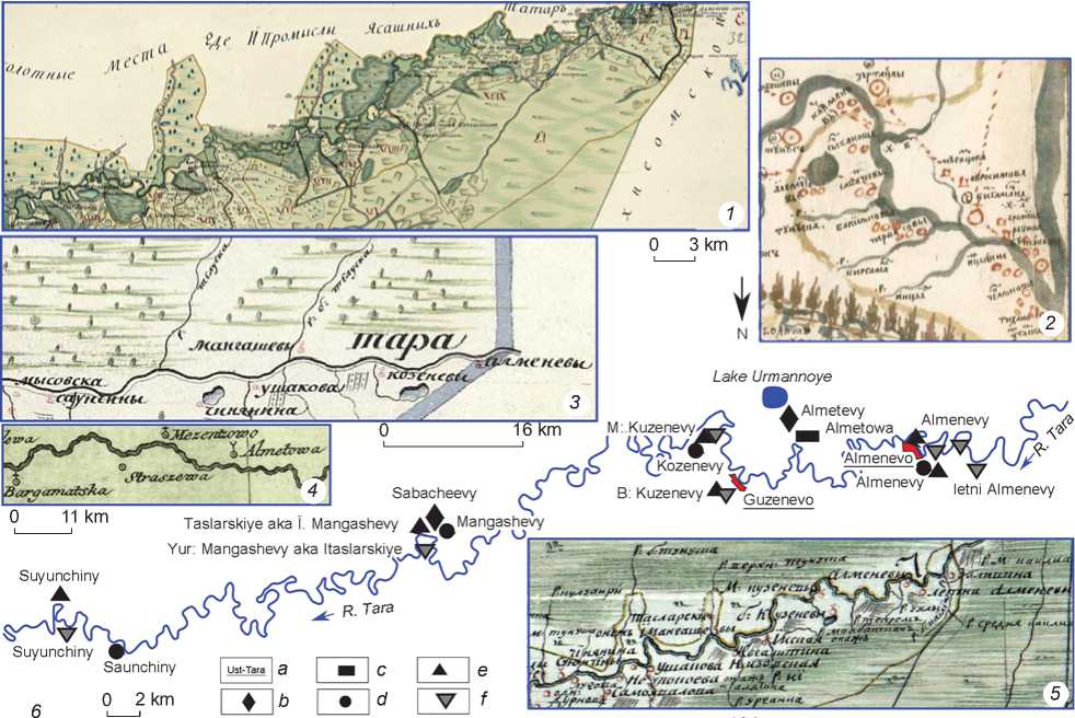
Fig. 2 . Tatar settlements in the area from the mouth of the Yulgonka River to the mouth of the Kalinka River on the maps of the 18th century.
1 – Topographic plan of 1798; 2 – Chorographic Drafting Book; 3 – Map of 1784; 4 – Map of 1780; 5 – Map of 1798; 6 – a diagram of the location of settlements (the modern ones and those indicated in the cartographic materials of the 18th century) in the Middle and Lower Tara region: a – modern names of settlements; b – in the Chorographic Drafting book; c – on the Map of 1780; d – on the Map of 1784; e – on the Map of 1798; f – on the Topographic Plan of 1798.
The Inventory Book indicates the “Temshenyakova (aka Mantabarova Kukunova)”, which was probably located higher upstream of the Tara (Korusenko S.N., 2006: 123). On the Map of 1784, at the mouth of the Bolshaya Teluska River (present-day Verkhnyaya Tunuska), on the right bank of the Tara River, upstream of the Tara River, the Mangashevy is marked (Fig. 2, 3 ). On the Map of 1798, on the right bank of the Tara, upstream from the mouth of the Verkhnyaya Tunuska, the Taslarskiye is shown, also known as Ï. Mangashevy (Fig. 2, 5 ). At present, the village of Lnozavod of the Muromtsevsky District, Omsk Region, is located here (Fig. 2, 6 ). On the Topographic Plan of 1798, the Taslarskye is indicated on the left bank of the Tara, in the area of Lake Sagartly, but with the name of Yur: (yurts) Mangashevy, also known as Itaslarskiye (Fig. 2, 1 ). A.F. Palashenkov marked the site of Nizovoye I in this place, pertaining to the Middle Ages. In his opinion, the Tatar town of Tunus was located here, in the Tatarsky Ostrov locality (Arkheologicheskaya karta…, 2000: 17; Korusenko M.A., 2002).
On the Map of 1784, the settlement of Kozenevy is indicated on the left bank of the Tara, upstream, near the drain of the lake that is now called Lebyazhye (Fig. 2, 3 ). On the Map of 1798, in the same area, the M: (Malyie) (‘small’) Kuzenevy is indicated, and on the northeastern shore of the same lake B: (Bolshiye) (‘big’) Kuzenevy (Fig. 2, 5 ). The Topographic Plan of 1798 gives the second name “Yur: B: Kuzevevy – aka Itaslarskiye” and indicates the exact location of these settlements (Fig. 2, 1 ). The fact that in the 20th century local residents were finding ceramics, bones, and arrowheads on arable land near the lake, suggests that the Bolshiye Kuzenevy yurts were located here (Korusenko M.A., Korusenko S.N., 2019: 218). The modern village of Guzenevo, Muromtsevsky District, Omsk Region, is located away from the mentioned lake, on the Tara River. (Fig. 2, 6 ).
The next settlement on the right bank of the Tara River, near a large lake, in the Chorographic Drafting Book is the settlement of Alemetevy (Fig. 2, 2 ) (Khorograficheskaya chertezhnaya kniga…, 2011: Ins. on fol. 93). Currently, there is only one large lake between the Tunuska and Cheka rivers, Urmannoye, which is located near the village of Malaya Skirla (Kyshtovsky District of the Novosibirsk Region) (Fig. 2, 6 ). It was probably on this lake that this settlement was indicated. In the Inventory Book, in this area, the “Sabancheyeva (aka the village of Almeneva)” is indicated (Korusenko S.N., 2006: 123). On the Map of 1780, the settlement of Almetowa is shown on the right bank of the Tara (Fig. 2, 4 ), and on the Map of 1784, on the left bank of the river called Almenevy (Fig. 2, 3 ). On the Map of 1798, on the right bank in this area, at the confluence of the Uyaly River in Tara, the Almenevy is marked; upstream of the Tara River, there is Letni Almenevy (Fig. 2, 5 ). On the Topographic Plan of 1798, from the mouth of the right Tara tributary
Bol. Uyaly River to the mouth of the Kailiairi (Kalinka) River, the following settlements are indicated: Yur: (yurts) Almenevy, Yur: (‘yurts’) M: (‘small’) Almenevy Letniye, Yur: (yurts) Verkhni Almenevy Letniye. Today, in this area, there is the village of Almenevo (Kyshtovsky District of the Novosibirsk Region) (Fig. 2, 6 ).
The next Tatar village upstream of the Tara River in the 18th century was located on the territory of the Tunusskaya district.
Findings
As a result of the analysis of cartographic materials, some patterns were revealed in the location of the Tatar settlements in the Middle and Lower Tara region in the 18th century:
-
1. The settlements were located on the right bank of the Tara, in the area from its mouth to the Chertalinka River. All known flat-grave burial grounds are also located on the right bank: Ust-Tara LXX, Cheplyarovo XXVII, Bergamak II, Chertalinsky burial ground, etc. (with the exception of Okunevo VII) and settlement complexes: Bergamak XXIII, Bergamak III, Chertaly I, which, according to researchers, belonged to the ancestors of the Tara Tatars (Etnografo-arkheologicheskiye kompleksy…, 2014; and others). In the section from Chertalinka to the mouth of the Kalinka, Tatar settlements are concentrated on the Tara’s left bank.
-
2. On the maps of the late 18th century, summer and winter settlements of the Tatars in the Middle and Lower Tara region are indicated. However, based on these materials, we cannot be sure that at the time the maps were created, these settlements were still seasonal in nature, and were not permanently inhabited. Information gathered by G.F. Miller about the winter aul Inzis (Intsis) and the summer settlement Isuk-aul (Izyuk-aul), the summer and winter settlements Tschupljar-aul allow us to speak confidently of the existence of the seasonal settlements in the first half of the 18th century (Sibir XVIII veka…, 1996: 93).
-
3. According to cartographic sources, winter settlements were located on a high terrace away from the Tara valley, and summer settlements were located in the floodplain on the river bank, near other villages. Moreover, as follows from the Topographic Plan of 1798, arable land was located on terraces.
Cartographic materials can be used to reconstruct the history of relocation of settlements. For example, the location of the village of Intsiss is marked at some point above the mouth of the homonymous river (modern location), and at other times below the river mouth; the village of Chertaly is indicated sometimes on the right, then on the left bank of the Tara, where it is located today. In the Chorographic Drafting Book, the Alemetevy settlement is recorded on the right bank of the Tara, near the lake, and at present, the modern village of Almenevo is located on the left bank, etc. The Tatar settlement of Yurt-Bergamak changed its location several times (from the Bergamak River to the left bank of the Tara River, in the area of the Okunevo village) (Landik (Tikhomirova), 1998).
Conclusions
Analysis of cartographic materials from the end of the 18th century and comparison of them with other sources has made it possible to reveal the unique informational potential of the Map of 1784, the Map of 1798, and the Topographic Plan of 1798. The data recorded in them fairly reliably reflect the historical situation in the Lower and Middle Tara by the end of the 18th century (administrative division, location of Tatar and Russian settlements, types of settlements: seasonal, single-yard, etc.).
When comparing the maps of the indicated period and modern maps, supplemented by archaeological research data, one can draw conclusions about the settlement system at the end of the 18th century: the Tatar settlements were located according to the riverine type. Some of their settlements gravitated towards the estuarine sections of the Tara tributaries; names on maps, such as Zimniye Bergamatski and Letniye Bergamatski yurts, Malye Almenevy Letniye, and Verkhni Almenevy Letni yurts, correspond to seasonal settlements.
A comparison of the maps of the period under consideration to modern ones allows us to conclude that the modern system of settlement of the Tatars of the Lower and Middle Tara region was mostly formed in the 18th century (changes in the location of settlements were insignificant and were carried out within the same district). Based on the data obtained, it is possible to find the locations of specific settlements more effectively and explore the early history of the Tatars on the banks of the Tara River.
Acknowledgements
References Location of Tatar settlements in the Middle and Lower Tara region according to 18th century maps
- Arkheologicheskaya karta Muromtsevskogo rayona Omskoy oblasti. 2000 M.Y. Zdor, S.F. Tataurov, K.N. Tikhomirov. Omsk: Omsk. Gos. Univ.
- Atlas. Tobolskaya Guberniya. 1798 RGIA. F. 1350, Inv. 312, D. 43-44.
- Bestmaps. (s.a.) URL: https://bestmaps.ru (Accessed April 24, 2021).
- Chertezhnaya kniga, sostavlennaya tobolskim synom boyarskim Semenom Remezovym v 1701 g. 1701 URL: https://archive.org/details/RemezovCHertezhnayaKnigaSibiri (Accessed February 15, 2021).
- Etnografo-arkheologicheskiye kompleksy narodov Tarskogo Priirtyshya: Prirodnaya sreda, etnosy, istochniki. 2014 M.L. Berezhnova, S.N. Korusenko, A.V. Matveev, S.F. Tataurov, L.V. Tataurova, K.N. Tikhomirov, S.S. Tikhonov, N.A. Tomilov. Omsk: Izdat. dom “Nauka”. (Etnografoarkheologicheskiye kompleksy: Problemy kultury i sotsiuma; vol. 13).
- Etnografo-arkheologicheskiye kompleksy narodov Tarskogo Priirtyshya: Mogily, mogilniki, pogrebalniy obryad i mir mertvykh v svete etnoarkheologicheskikh rabot. 2016 M.L. Berezhnova, M.A. Korusenko, A.V. Polevodov, L.V. Tataurova, K.N. Tikhomirov, S.S. Tikhonov. Omsk: Izdat. dom “Nauka”. (Etnografo-arkheologicheskiye kompleksy: Problemy kultury i sotsiuma; vol. 14).
- Falk I.P. 1824 Polnoye sobraniye uchenykh puteshestviy po Rossii, izdavayemoye Imperatorskoy Akademiyey Nauk, po predlozheniyu yeyo prezidenta, s pril., izyasn. i dopoln. Vol. 6: Zapiski puteshestviya akademika Falka. St. Petersburg: Pri Imp. AN.
- Gnucheva V.F. 1946 Geografi cheskiy departament akademii nauk XVIII veka. Moscow, Leningrad: Izd. AN SSSR. (Trudy Arkhiva AN SSSR; iss. 6).
- Karta Tarskogo uyezda s polozheniyem mest s okrugoy i s obyasneniyem vsekh seleniy bolshikh i malykh dereven i zhivykh urochishch s razdeleniyem volostey po novomu obrazu poryadka ustanovlennykh na pokazanii obrochnykh statey i drugikh kazennykh imushchestv, sochinennaya po opisaniyu 1784 goda uyezdnym zemlemerom podporuchikom Kammerom. 1784 In Geograficheskiy atlas Tobolskogo namestnichestva, sostoyashchiy iz XVI uyezdov [Atlas]: Sochinen po opisaniyu uyezdnykh zemlemerov. Tobolsk: Tobolskaya Chertezhnya, p. 16.
- Khorografi cheskaya chertezhnaya kniga Sibiri S.U. Remezova. 2011 Tobolsk: Obshchestv. blagotvorit. fond “Vozrozhdeniye Tobolska”.
- Konovalova E.N., Popov V.A. 2010 Atlasy Tobolskoy gubernii vo vtoroy polovine XVIII-XIX v. Geo-Sibir, vol. 6: 125-130.
- Korusenko M.A. 2002 Otchet ob arkheologicheskoy razvedke uchastkov srednego techeniya r. Tara (Muromtsevskiy rayon Omskoy oblast) v 2001 g. Omsk, 2002, 23 s. Arkhiv Muzeya arkheologii i etnografii Omskogo gosudarstvennogo universiteta im. F.M. Dostoyevskogo. F. II, D. 165-1.
- Korusenko M.A. 2013 Raboty v nizovyakh r. Tara na mogilnike Cheplyarovo XXVII. In Arkheologicheskiye otkrytiya 2009 goda. Moscow: IA RAN, pp. 295-296.
- Korusenko M.A., Korusenko S.N. 2019 Ayaly ili Baraba: Istoriya poseleniya na granitse grupp. Vestnik Omskogo gosudarstvennogo universiteta. Ser. Istoricheskiye nauki, No. 2 (22): 214-221.
- Korusenko S.N. 2006 Etnosotsialnaya istoriya i mezhetnicheskiye svyazi tyurkskogo naseleniya Tarskogo Priirtyshya v XVIII- XX vekakh. Omsk: Izdat. dom “Nauka”.
- Korusenko S.N., Tomilov N.A. 2011 Tatary Sibiri v XVIII - nachale XX v.: Rasseleniye, chislennost i sotsialnaya struktura. Vestnik arkheologii, antropologii i etnografi i, No. 2 (15): 177-185.
- Korusenko M.A., Zdor M.Y., Gerasimov Y.V. 2015 Poleviye raboty na poselenii Chertaly I (2010-2011 gg.) i mogilnike Chertaly III/IV (2010-2013 gg.). In Arkheologicheskiye otkrytiya 2010-2013 godov. Moscow: IA RAN, pp. 664-665.
- Landik (Tikhomirova) M.N. 1998 “Kochuyushchaya” derevnya Yurt-Bergamak. In Sibirskaya derevnya: Istoriya, sovremennoye sostoyaniye, perspektivy razvitiya: Materialy Vtoroy Vseros. nauch.-praktich, konf. Omsk: Izd. Om. Gos. Agrar. Univ., pp. 105-107.
- Omskaya oblast. 2010 [Atlas]. Omsk: Om. kartogr. fabrika. (Regiony Rossii).
- Sibir XVIII veka v putevykh opisaniyakh G.F. Millera. 1996 Novosibirsk: Sibirskiy khronograf. (Istoriya Sibiri. Pervoistochniki; iss. VI).
- Tabula Exhibens Cursum Fluvii Irtisch ab Omskaja Krepost usque ad Tobolsk. Composita a Iohanne Islenieff, anno 1780. 1780 URL: https://uralica.kansalliskirjasto.fi/Record/fuhub-GOTPPN352799242 (Accessed March 5, 2021).
- Tikhomirov K.N. 2016 Vizualniy analiz kladbishch tyurkoyazychnogo naseleniya Srednego Priirtyshya i arkheologicheskiye materialy iz mogilnikov XVI-XVIII vekov v nizovyakh r. Tary. In Etnografo-arkheologicheskiye kompleksy narodov Tarskogo Priirtyshya: Mogilniki, pogrebalniy obryad i mir mertvykh v svete etnoarkheologicheskikh rabot. Omsk: Izdat. dom “Nauka”, pp. 66-147. (Etnografo-arkheologicheskiye kompleksy: Problemy kultury i sotsiuma; vol. 14).
- Tikhomirov K.N., Nikonova V.G. 2016 Nekotoriye ekologicheskiye i ekonomicheskiye aspekty zhizni tyurkizirovannogo naseleniya nizovyev r. Tara XVII- XVIII vekov (po materialam issledovaiya proizvodstvennoy ploshchadki poseleniya Bergamak III). In Ekologiya drevnikh i traditsionnykh obshchestv: Sbornik dokl. konf., iss. 5 (2). Tyumen: pp. 158-160.
- Tikhonov S.S. 2004 Rasseleniye sibirskikh tatar i russkikh v Srednem Priirtyshye v pervoy treti XVIII v. (po materialam G.F. Millera). In Etnografo-arkheologicheskiye kompleksy: Problemy kultury i sotsiuma, vol. 8. Omsk: Izdat. dom “Nauka”, pp. 200-233.
- Tikhonov S.S. 2009 Yugo-vostochnaya okraina Sibirskogo khanstva Kuchuma (interpretatsiya istochnikov po ekonomike i sotsialnomu razvitiyu tarskikh tatar). In Srednevekoviye tyurko-tatarskiye gosudarstva. Kazan: Inst. Istorii im. S. Mardzhani AN RT, pp. 162-171.
- Titov E.V. 2007 Zhilishcha tatar tarskogo Priirtyshya v kontse XIX - XX v. Omskiy nauchniy vestnik, No. 4 (58): 22-25.
- Tomilov N.A. 1981 Tyurkoyazychnoye naseleniye Zapadno-Sibirskoy ravniny v kontse XVI - pervoy chetverti XIX v. Tomsk: Izd. Tom. Gos. Univ.
- Tomilov N.A. 1996 Poseleniya tarskikh tatar basseina Tary. In Etnografoarkheologicheskiye kompleksy: Problemy kultury i sotsiuma. Vol. 1: Kultura tarskikh tatar. Novosibirsk: Nauka, pp. 188-197.
- Tomilov N.A. 2011 Etnokulturniye protsessy u tatar Zapadnoy Sibiri v XVIII- XIX vekakh. Omsk: Izdat. dom. “Nauka”.
