On the history of Asian Bosporus in the early Byzantine times: excavations at Verkhnegostagaevskoye

Author: Malyshev A.A., Dryga D.O., Klemeshov A.S., Smekalova T.N.
Journal: Archaeology, Ethnology & Anthropology of Eurasia @journal-aeae-en
Section: The metal ages and medieval period
Article in issue: 4 т.45, 2017.
Free access
Short address: https://sciup.org/145145340
IDR: 145145340 | DOI: 10.17746/1563-0110.2017.45.4.034-044
Text of the article On the history of Asian Bosporus in the early Byzantine times: excavations at Verkhnegostagaevskoye
Archaeological records of the Northern Black Sea region and the ancient Bosporus state (Blavatsky, 1985; Frolova, 1998: 249), which was located there at the turn of the Late Antiquity and Early Byzantine period (3rd–6th centuries), are of particular importance for research into the history of the region mentioned by ancient authors in insufficient detail. Processes that led to the desolation and decline of the economic and political system (Gaidukevich, 1949: 439–484; Blavatsky, 1985; Kruglikova, 1966: 9–24) occurred at that time over large areas of the
Northern Black Sea region, including the Asian part of the Bosporus. Written sources scarcely report about the movement of the Barbarian tribes, for example, the Goths, over the territory of the Asian Bosporus. The “Anonymous Periplus”, which is traditionally dated to the 5th century, albeit including the fragments of earlier works (Agbunov, 1987: 13–15), mentions the center of the Eudusians (the Goths-Tetraxites), associated with the former ancient Gorgippia-Eudusia (Ibid.: 15). The Byzantine historian of the 6th century Procopius of Caesarea mentioned that the Goths-Tetraxites were in close proximity to the place of Eulysia or on its territory (Prokopiy Kesariyskiy, 1950: IV. 4, 7), which is identified with Eudusia of the “Anonymous Periplus” (Medvedev, 2011).
This information has no archaeological support: sites associated with everyday life of the Late Antiquity– Early Middle Ages in this region are almost unknown (Kovalevskaya, 1981: Fig. 57; Gavritukhin, Pyankov, 2003: Fig. 12). Therefore, dating the ancient fortress with powerful fortifications, which was discovered there in 2013, to the Migration Period (4th–7th centuries) became a notable event.
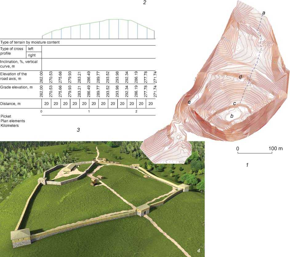
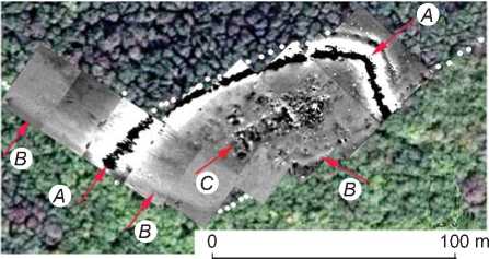
A topographic survey carried out at the fortress has clarified the available cartographic materials (1 : 10,000 scale) (Fig. 1). The series of GPS-points was correlated with the aerial photographs of 1943 from the collection of the National Archives of the U.S., and satellite images (Fig. 2, 1 , 2 ). A comparative analysis of these materials has allowed us to obtain the dimensional characteristics of the fortress and to evaluate its fortification and communication capacities, as well as the economic feasibility of its creation. Judging by the traces of roads and open spaces, in the mid-20th century the site was used for economic needs more intensely than in ancient times, although the landscape did not undergo any significant changes.
In 2013 and 2015, works for identifying and studying the building remains of the ancient fortress using nondestructive methods (magnetic survey) were carried out on the upper fortified ground, or citadel, and in the adjacent defensive structures (Fig. 2, 3, 4). This research method is a proven effective way of studying settlement structures, in particular, fortifications (Smekalova et al., 2016). During the excavations of the fortress, which lasted for four years, the cultural layer and the elements of the most important objects of the fortification system and everyday life of the monument were studied. Laboratory studies of the obtained materials (establishing the content of the phosphorus compounds in the deposits of the fortress and analyzing paleobotanical samples)* made it possible to establish specific features of the cultural layer at various parts of the site, to clarify the range of building materials used, and to obtain new data on the chronology of the monumental citadel structure.
The study of the fortress was carried out using nondestructive and destructive methods; thus, these studies can be described as comprehensive. The article summarizes the results of the above works, which have made it possible to clarify the topography, stratigraphy, and chronology of this cultural heritage site discovered in 2013.
Fortificationof the Verkhnegostagaevskoye settlement
The fortress is located on the northern slope of the watershed ridge between the Kotlama and Gostagaika rivers, which belong to the Black Sea basin. The structures of the fortress occupy almost the entire area (2.7 ha) of the promontory, which has an irregular shape close to quadrangular. The terrain of the promontory is very sophisticated: its territory comprises absolute marks ranging from 280 to 294 m; the inclination angle of the slopes reaches 40° in the eastern and northeastern directions and 25–30° in the western and northwest directions (see Fig. 1, 2 , 3 ). On the southeast, west, and northwest, the promontory is bounded by deep ravines connected with the basin of the Gostagaika River. An elongated, large (about 0.8 km) isthmus adjoins the base of the promontory on the northern side. An important feature for the system of fortification and communication is the crest of the ridge, which cuts through the territory of the fortress and isthmus in the meridional direction (hereafter referred to as “the meridional ridge”) (see Fig. 1, 1 , a ).
The strength and inclined bedding of rocks ensure the stability of the northeastern and eastern slopes of the promontory, which fosters the erection of monumental structures in the area even despite the great inclination of the slope. The fortress had two lines of stone defensive structures: a wall around the perimeter of the entire settlement and an additional wall that fenced the citadel from the main part of the fortress.
Citadel
The upper ground of the promontory covering an area of 0.5 hectares, where the citadel of the fortress is located, is of subrectangular shape and is stretched along the NE-SW axis. The boundary of the citadel is a rampart-like embankment, which can be well seen on both topographic plans and aerial images (see Fig. 2). Magnetic survey has revealed an interesting feature of the citadel fortification:

Type of terrain by moisture content
Picket
Plan elements
Kilometers
у – 81°28ʹ24ʹʹ у – 61°13ʹ50ʹʹ у – 72°31ʹ60ʹʹ у – 22°33ʹ24ʹʹ у – 35°28ʹ13ʹʹ
R – 6.93 R – 6.05 R – 6.05 R – 6.05 R – 6.05
у – 83°20ʹ03ʹʹ у – 10°28ʹ25ʹʹ у – 96°33ʹ26ʹʹ
R – 4.41 R – 4.41 R – 4.41
а
Type of terrain by moisture content left right
Grade elevation, m
Distance, m
b
100 m
Elevation of the road axis, m
Type of cross profile
Picket
Plan elements Kilometers
Inclination, %, vertical curve, m
Fig. 1 . Verkhnegostagaevskoye fortress and its environs.
1 – topographic map: a – “the meridional ridge”, b – location of the monumental structure on the citadel, c – hypothetical location of the entrance structure of the citadel, d – entrance structure at the fortress, e – excavation at the outer defensive wall; 2 – cross-section of the fortress along the W-E axis; 3 – cross-section of the fortress along the N-S axis; 4 – 3D reconstruction of buildings at Verkhnegostagaevskoye fortress (by V.V. Moor).
Fig. 2 . Materials of aerial photography of the fortress in 1943 ( 1 ); a satellite image taken on February 24, 2011 ( 2 ); magnetic field map superimposed on the satellite image (made by T.N. Smekalova and A.V. Chudin) ( 3 , 4 ): A – intense positive magnetic anomaly from the inner wall of the citadel; B – weak negative anomaly from the outer wall of the fortress; C – anomalies from the rectangular monumental structure inside the citadel.
the inner wall fencing the “acropolis” was built of stone and heavily burned clay-wattled or adobe structures. They appeared in the magnetic field in the form of a rectilinear negative anomaly (the wall material was nonmagnetic stone) (see Fig. 2, 4 ). This observation was made as a result of the strong positive magnetic anomaly above the wall, the same anomaly as the one over the walls of the Rayevskaya and Krasnaya Batareya fortified settlements. During a fire, the clay underwent high-temperature impact, which caused its burning, slagging, and magnetization.
For building the rampart-like embankment, the slope of the watershed ridge was made into an escarp by the creators of the citadel to the northwest and northeast. Since these ramparts were joined at the crest of “the meridional ridge”, taking into account the irregularities of the terrain, their contour does not have a regular geometric shape.
The outlines of a road on the inside of the embankment and a noticeable “dip” in the terrain suggest that the entrance to the citadel was located at the northern part of the embankment. The height of the embankment on the western side is over 3 m, and on the northern and northeastern side it is over 2 m. The southwestern, southern, and eastern corners of the citadel are distinctly outlined. Judging by the terrain, the walls on the southeastern side were built on a small earth embankment, and to the southwest simply on the layer of rock.
The issue remains as to whether tower structures were located in the southwestern, southern, and northern parts of the fortification at the turning points of the rampart- like embankment. A rectangular area of about 6 × 6 m can be found only at the junction of the northeastern and southeastern sections of the rampart-like embankment. The strategic need for a tower in this area for controlling access to the citadel gates is obvious.
The interior of the citadel is characterized by a complex relief with height difference reaching 9 m. In the southwestern part, there is a steep slope approximately 26 m wide, which ends at the edge of an even steeper cliff. It cannot be excluded that it was possible to enter the citadel from the side, from the junction of the rampart-like embankment and the southern precipitous promontory slope of the fortress.
Most of the citadel area is a natural plateau of oval shape measuring 26 × 47 m (and about 294 m high) on the top of the promontory, oriented just like the entire citadel along the NE-SW axis. If we do not take into account the significant difference in height on the southwestern slope, the height difference does not generally exceed 1.0–1.5 m. The terrain of the adjacent territory, judging by the folds which are also visible behind the rampartlike embankment, corresponds to the natural relief of the plateau.
Monumental structure
The magnetic survey conducted in 2013–2015 on the plateau mentioned above, revealed a rectangular structure (with the approximate dimensions of 10 × 30 m), oriented along the axis of the plateau. Judging by the negative magnetic anomalies, the foundations of the walls of the structure were made of stone. The eastern and western walls of the structure are additionally marked by strong positive anomalies. It is possible that adobe bricks, which became magnetized in a large fire, were used for erecting these walls. An extensive alternating anomaly of a mosaic structure corresponding to the collapsed burned adobe walls and possibly the tiled roof can be observed to the east of the rectangular structure.
In 2014–2016, the main part of the monumental structure was explored by excavations (Fig. 3, 4); the masonry of three walls was cleared for a width of about 1.2 m; the longitudinal walls were traced for approximately 17 m, and the transverse wall was traced for approximately 10 m.
The facades of the walls have been preserved up to the height of 0.6–0.7 m (three to four rows of stonework). Despite the impact of slope deformation, especially noticeable on the longitudinal northeastern wall, the masonry retained its distinct row structure (Fig. 4, 3 , 4 , 6 ). The external facades of the walls that form the northern corner of the building facing the entry gates of the citadel, were built of large, 0.15–0.20 m high, quadrels of polished shell limestone (Fig. 4, 6 ). The internal facades were made of stones usually of smaller size; local limestone occurs more frequently.
Doorways approximately 1.6 m wide were made for entering the building. In the longitudinal walls they are arranged in pairs. The bases of the thresholds are composed of three rows of objects of short cylindrical shape (probably, column shaft drums) made of shell limestone, and are paved on top with thin limestone slabs (see Fig. 3). The pavement on the outside of entrances 1 and 4 marks the ancient day surface and indicates a slight deepening of the building walls using one foundation row of masonry at approximately 0.2 m. Drums of column shafts made of shell limestone with a diameter of about 0.4 m have also been found in the lower foundation row of stonework.
Piles of collapsed stonework were found everywhere in the filling of the room. Cleared piles of building stone make it possible to reconstruct the height of the outer wall which might have reached 1 m. The remains of longitudinally burned oak slabs interspersed with the fragments of roofing tiles and accompanied by layers of ash and adobe mortar were found within the building. This layer, in our opinion, was formed by the remains of the roofing which collapsed during the fire. According to the building tradition of Antiquity, the roof was tiled (see Fig. 4, 6 ).
Most of the fragments belong to flat roof tiles (keramides) with upstands along two longitudinal sides. The overall dimensions (different widths) and, most importantly, the design features of the lateral upstands which are associated with a placement technique not typical of the Hellenistic period, make it possible to date the finds to the Roman period (Zeest, 1966: 59–60). Approximately half of the fragments belonged to roof tiles which were made of a red-brown clay mixture typical of the production of ancient Gorgippia in the Roman period. The material of the roof tiles is characterized by a porous structure, coarse-grained impurities of grog, sand, and white grains (lime) (Kruglikova, 1966: 148).
External defensive line
The space between the citadel embankments and the outer line of defensive structures is extensive; its area exceeds 2 hectares. The significant inclination of the surface was important for fortification purposes, but created many problems for economic activities. Traces of economic use of this area (terracing, presence of a cultural layer) on the slope are absent, and traces of re-planning (escarps or upfilling) have been found only along the outer perimeter of the fortress.
Intensive economic activity was also hampered by the shortage of water: it was practically impossible to obtain water from the wells on the territory of the fortress. The availability of a system for collecting and storing rainwater has not yet been confirmed by archaeological research.
The building of the external defensive contour with a total length of about 675 m required significant efforts during the construction of the fortress. The shortest westnorthwestern section approximately 140 m long was inscribed into the slope, which had an internal bend in the form of an amphitheater (see Fig. 1). The natural fracture of the slope was made into an escarp, and the break of the isolines on the topographic plan makes it possible to establish the width of the resulting terrace, reaching about 20 m. The soil was most likely used for constructing a rampart-like embankment on the field (northern) side of the fortress.
A barely noticeable elevation can be presently observed along the outer edge of the terrace around the entire external perimeter of the fortress. As excavations have shown, a layer of dark gray dense loam, which are probably disintegrated adobe bricks, covered the foundations within 1 m of the two-faced defensive wall 1.0–1.1 m wide (see Fig. 1, 1 , e ), composed mainly of large slabs of local rocks—limestone and sandstone. Judging by a sharp break in the isolines, a patrol trail or road up to 3 m wide used to pass along the external defensive wall. Almost half of the south-southwestern and east-southeastern sections of the outer perimeter are associated with the fortification of the citadel.
The entrance to the fortress, flanked by rampart-like embankments, was located in the southeastern corner. The embankment of the road leading to the entrance was made
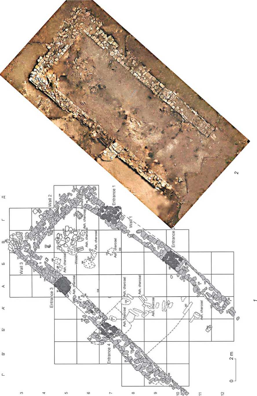
Fig. 3 . Consolidated plan ( 1 ) and aerial photograph ( 2 ) of the monumental structure on the territory of the citadel.
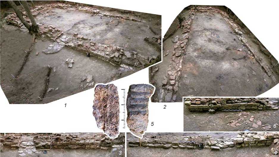
Fig. 4 . Monumental structure on the territory of the citadel.
1 – view from the southwest; 2 – view from the south; 3 – opening of entrance 4 with a ramp, external facade of wall 3; 4 – opening of entrance 1, the base of the external facade of wall 1 built of sections of column shafts; 5 – fragment of an object of shell limestone; 6 – external “frontal” facade of wall 3, with piles of roofing tiles in the foreground.
through a deep ravine. A small cape-like protuberance measuring 5 × 10 m on the slope of the fortress suggests that originally it was possible to enter the fortress by a bridge. Judging by the route of the access road on the aerial photograph taken in 1943 (see Fig. 2, 1 ), the situation in that area has practically not changed since the time of the photograph.
The most important and labor-consuming task was to build the fortification system in the field (northern) side. This complexity was conditioned by the considerable length of about 230 m, as well as height differences up to 10 m in the latitudinal direction. Currently, the access to the settlement is covered by a rampart-like embankment whose height from east to west doubles, to 4 m. The absence of traces of the outer ditch confirms the assumption that soil obtained from terracing the slopes during the construction of structures of the external defensive line and communications inside the fortress was used for making the embankment. Extensive areas of tower structures have been found in the places where the embankment joined other sections of the external defensive contour.
The above mentioned “meridional ridge” played a crucial role in the topographic situation in the northern part of the settlement. The northern rampart-like embankment “leans” on it in its middle part and thus acquires a convex outline in plan. In addition, this ridge determined the location of the access road from the valley of the Gostagaika River and the entrance to the fortress.
The entrance structure was discovered due to a saddle-shaped depression in the northern rampart-like embankment; the excavations revealed stonework of a monumental structure over 2 m high built in the lightgray loam of the native soil (see Fig. 1, 1 , d ). A filling in the form of burned light beige or pinkish clay with coarse-grained structure has been observed above the stonework. This filling resulted from disintegrated adobe bricks, which confirms the assumption of the use of the combined adobe-and-stone building tradition of Antiquity in the fortification.
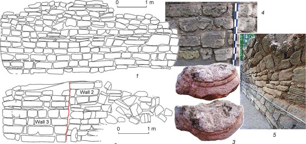
Wall 3, oriented along the axis of the rampartlike embankment, constitutes the basis of the entrance structure. Clearing the southern (interior) facade made it possible to establish the heterogeneous nature of masonry over its entire height (over 2.6 m) (Fig. 5, 1 ). The lowest row, constituting the foundation, is built of stones which vary in height in order to reduce the unevenness of the ancient day surface. The next four rows consist of standard blocks of shell limestone of regular shape measuring 0.15–0.2 × 0.2 × 0.5 m. The quadrels bear the traces of saws and tools of primary processing (Fig. 5, 4 ) (cf. (Wright, 2005: Ill. 90)). The majority of the blocks, which are of dark gray color, are permeated with humus. This, along with the indices of the content of specific
0 30 cm
Fig. 5 . Entrance structure, wall 3.
1 – internal surface; 2 – surface of the internal space of the entrance structure; 3 – fragment of a capital of a column of Doric order from the masonry of wall 3; 4 , 5 – traces of processing on masonry blocks.
phosphorus in the soil, indicates that the masonry was covered by the cultural layer up to a height of 0.8 m.
The upper rows underwent a strong longitudinal deformation, which caused the tilt of the upper rows of the masonry and even their noticeable horizontal shift (Fig. 5, 5 ). The variation in the sizes of stone blocks increases noticeably in the upper levels, and unprocessed plates made of local rocks (limestone and sandstone) start to appear. Careless masonry in the upper rows might have resulted from hasty or unprofessional repairs after the collapse of the structure due to slope deformation or enemy attack.
The eastern end of wall 3 (2 m wide) forms the surface of the inner part of the entrance structure (Fig. 5, 2 ; 6). A buttress consisting of three walls (No. 2, 4, 5) was added to the outside of wall 3 for compensating for the impact of slope deformation. The joining of walls 2 and 3 end-to-end indicates that the external structure appeared at a later time. The elements of a similar structure were also traced on the opposite side of the entrance structure.
The stonework on the surfaces of the walls forming the internal space of the gates is strongly burned and shows a significant tilt inwards. We may assume that during a siege, the oak gates were burned; the design of the part of the building above the gates collapsed and blocked the passage with building stones mixed with charcoal and adobe debris. During the excavation, the internal space of the entrance structure was cleared about 6.5 m in length; the laying of a stone threshold was found in the entrance at a width of 3 m (Fig. 6).
Dating
Materials obtained through archaeological excavations have allowed us to establish the period when the fortress existed in the systems of relative and absolute dating. The lower border (the early 4th century BC) is given by a single coin, a bronze Bosporus stater of Radamsad (318/319 BC (309/310–322/323))* (Frolova, 1997: Pl. LXXXIV, 27–29 , pp. 319–321) (Fig. 7, 2 ). More numerous pottery finds include the fragments of red-glazed tableware and amphorae, typical of the cultural layers of the Black Sea sites of the late 4th–5th century**. Red-glazed pottery, which is represented both by the imported forms of LRC (Late Roman Ceramics) 3C (Fig. 7, 4–6 ) (Hayes, 2008: Fig. 39, 1269, 1270, 1272, 1273), LRC 3B (Fig. 7, 7 ) (Ibid.: Fig. 38, 1262), PRSW (Pontic Red Slip Ware) 1 (Fig. 7, 12 ) (Sazanov, 2012b: Fig. 1, 6 , pp. 135–138), and local imitations PRSW 7 (imitation of Hayes LRC 2) (Fig. 7, 9–11 ) (Sazanov, 2012a: Fig. VII.3, 1 , p. 213), goes back to the period from the late 4th to the third quarter of the 5th century.
The objects from the not very numerous amphora collection do not contradict that chronological framework and show the chronological indicators typical of the Northern Black Sea coast of Late Antiquity: profile parts of narrow-necked amphorae of light-colored clay of types E and F (Fig. 7, 1 , 3 ) (Sazanov, 2012b: 125–133),
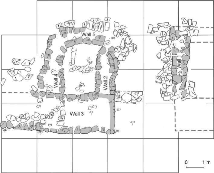
Fig. 6 . Consolidated plan for the excavation of the entrance structure.
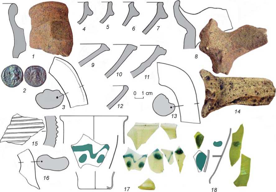
Fig. 7 . Materials used for dating.
1 , 3 , 8 , 13–16 – fragments of amphorae; 2 – Bosporus stater of King Radamsad; 4–7 , 9–12 – fragments of tableware pottery, red glaze; 17 , 18 – fragments of glass vessels.
as well as the handles and walls of the LRA (Late Roman Amphora) forms 1A (Fig. 7, 8 , 13 , 14 ) (Sazanov, 2007: 803–804), LRA 2 (Fig, 7, 15 ) (Ibid.: 804), and LRA 3 (Fig. 7, 16 ) (Ibid.: 804–806, fig. 4, 8, 9, 20, 32, 33).
The fragments of two glass vessels of transparent olive color with drops of blue glass on the body, which were found on the territory of the citadel, are also typical of the Late Antiquity of the Northern Black Sea coast of the late 4th–second half of the 5th century. One of the fragments is decorated with an ornamented belt of festoons, drops of blue glass, and bands; the other fragment has drops and polished bands (Fig. 7, 17 , 18 ). The contours of the vessels make it possible to reconstruct a conical body; one fragment retained a part of a narrow flattened base (Isings, 1957: Form 109; Sorokina, 1971: 90, type II; Sazanov, 2012b: 140–142).
The materials of the absolute dating and the results of the 14C analysis of two charcoal samples from the filling of the monumental structure reveal dates corresponding to the final stage of the existence of this complex in the Late Antiquity–Early Byzantine period: from the second half of the 5th (472 (430 ± 60)) to the 6th centuries (598 (590 ± 60))*.
Discussion
The remoteness from the main transportation arteries on the sea and on land (20 km from the lower reaches of the Anapka River (Gorgippia, the Black Sea) and the Gostagaika River (fortress near the villages of Kapustin and Vityazevsky Liman)) allows us to view this monument as a refuge fortress of very high rank. The minimum content of specific phosphorus and the scarcity of mass materials in the cultural layer of the fortress (Golyeva, Malyshev, 2003) indicate a low intensity of economic activity and a low population density.
There is no doubt that the fortress occupied an advantageous geographical and strategic position. It was erected in the area of the axis of the last significant spur on the northwestern tip of the Main Caucasus Range. In ancient times, just as now, this ridge divided the territory into various natural zones and at the same time served as a bridge that from olden times connected two regions: the northern with steppe dominating, and the southern, covered with the forests of the foothills.
The territory with terrain more favorable for communications is located to the north of the fortress. The fairly wide and low-sloped crest of the above “meridional ridge” extends in the latitudinal direction and leads to the upper reaches of the Gostagaika River. The active use
*The analyses were carried out by E.P. Zazovskaya at the Radiocarbon Dating Laboratory of the Institute of Geography of the Russian Academy of Sciences.
of this zone is evidenced by the abundance of building material of shell limestone. It is known that the area of buildings made of this type of stone gravitates towards the lower reaches of the Kuban River. Judging by the elements of columns discovered here, which include a capital of a Doric column dated by the very flat echinus to the Late Hellenistic–Roman period*, the remains of a destroyed public building were reused as construction materials (see Fig. 5, 3 ). The presence of roof tiles made of clay similar to the Gorgippian clay mixture, as well as entranceways facing the Anapa Valley, confirms the assumption that the construction material could have been delivered from the west.
The scale of building activities testifies to considerable administrative resources possessed by the rulers of this center. Highly professional specialists who knew the specific features of the microrelief and local construction materials were engaged in the construction work. It is possible to draw a conclusion about a differentiated approach to the building materials: shell limestone, which was brought from afar, was used for creating the main structures, while local sandstone and limestone were used for building peripheral defensive structures. The delivery of construction materials and building of the fortress might have been a long-term servile obligation of the population of the Asian Bosporus.
Conclusions
Recently, it has been suggested that the beginning of the systemic crisis was triggered by the population of the region that is known in the scholarly literature as the Abrau Peninsula (Sazanov, 2011). It is no accident that many scholars locate there the political entity associated with the minting of the famous imitations of the Roman denarii (Kruglikova, 1966: 203; Shelov, 1973). These imitations mark the movement along one of the oldest routes connecting the Black Sea coast through the Kuban region with the Central Ciscaucasia (Shelov, 1973: 193).
Comprehensive studies of the Verkhnegostagaevskoye fortress, which was fortified in the traditions of Antiquity, provide new information about one of the least studied periods in the history of the Asian Bosporus.
Acknowledgements
Field research using nondestructive methods (archival aerial photographs, satellite images, and magnetic survey) and analysis of the materials obtained were carried out by Dr. T.N. Smekalova as a part of the Public Contract No. 33.1470.2017/ПЧ of the Ministry of Education and Science of the Russian Federation;
the geodetic survey and aerial survey of the objects, which were performed by D.O. Dryga, were supported by the Russian Foundation for Basic Research (Project No. 16-06-00564).
