Petroglyphs from northeast China: new sites and interpretations

Author: Zabiyako A.P., Jianlin W.
Journal: Archaeology, Ethnology & Anthropology of Eurasia @journal-aeae-en
Section: Art. The stone age and the metal ages
Article in issue: 3 т.45, 2017.
Free access
Short address: https://sciup.org/145145328
IDR: 145145328 | DOI: 10.17746/1563-0110.2017.45.3.069-078
Text of the article Petroglyphs from northeast China: new sites and interpretations
Northeast China or Dongbei is a geographically relatively isolated and historically distinctive region of East Asia, which was previously also known as Manchuria. It is surrounded by fairly high mountain systems almost on all sides. The ridge of the Greater Khingan, which forms the northwestern border separating Dongbei from Mongolia and accordingly Central Asia from East Asia, stretches for 1200 km from north to south. The highlands of Liaoxi (Rehe) are in the south. The northeastern boundary is the mountain massif of the Lesser Khingan; the highlands of Laoeling (Laoling) and the Manchu-Korean Mountains are in the southeast. The great Manchurian Plain (Songliao) of about 300,000 km2 is surrounded by these mountain systems. Two large corridors, formed by the floodplains of the large rivers Liao and Sungari, open the plain to the Yellow Sea in the south and to the Amur River in the east.
This integral region, which is diverse in terms of landscape and climate, provided a wide range of opportunities for the life and development of humans who practiced an appropriating economy of hunting, fishing, and gathering, as well as a producing economy of agriculture and cattle breeding. For tens of thousands of years, the Northeast of China was one of the most important centers of anthropogenesis and the emergence of ancient cultures and human populations. During the Early Iron Age and the Middle Ages, tribal associations and state entities, which played an
important role in the history of East and Central Asia, were formed here.
The importance of this region for the history of East Asia has long been recognized by archaeologists and anthropologists. Already in the first third of the 20th century, Russian archaeologists from the Society for the Study of the Manchurian Region, as well as Chinese, Japanese, and Western European scholars, conducted field research there. Despite the outstanding discoveries made in the last century, the study of this region was still on the periphery of the main studies, partly determined by the idea of the monocentric origin of the Chinese civilization, and primarily focused on the sites of North China and the Yellow River basin. For a long time, the access of Russian and other foreign scholars to Dongbei was hindered due to political reasons.
In recent decades, the situation has changed significantly. On the one hand, the concept that the Chinese civilization was formed on the basis of integrating cultures which emerged relatively autonomously in different adjacent regions of China, started to dominate. Scholars have recognized that the Paleolithic and Neolithic cultures of the Northeast played a paramount role in the genesis of the Chinese civilization, and this approach fostered the study of the Dongbei cultures. On the other hand, Chinese and international scholars have gained new opportunities for studying the history of the region and for sharing their knowledge. Nevertheless, the study of ancient and medieval cultures, including the rock art of Northeast China, is at an early stage.
Dongbei petroglyphs in publications by Chinese scholars
Dongbei rock art is still an understudied phenomenon. Owing to historical issues (political instability, military conflicts, etc.), inaccessibility of many sites in this vast region, and other factors, the study of petroglyphs in Manchuria has been slow. The results of studying rock paintings of Dongbei by Chinese scholars are presented in books and articles by Wang Yulang (2011), Liu Wuyi (2010), Zhang Xirong (2010), Yasha Zheng (2014), Chen Zhaofu (2009), etc. The works of Dong Wanlun (1998) and Ge Shanlin (2004) are distinguished among the Chinese publications by the completeness of the description of the petroglyphs.
Some rock representations (such as Jiaolaohedao, Qunli, Daheishan) have been thoroughly analyzed, dated, and placed into historical context in the studies by Chinese authors; some drawings have been compared with rock art of the adjacent territories (primarily Inner Mongolia and the Lower Amur region). The publications have reproduced, as a rule, in black and white, the compositions and individual representations of the Dongbei petroglyphs.
A summarized overview and brief interpretations of several sites of the region were published in 2014 by the Chinese scholar Yasha Zheng (2014).
With all due respect to the studies of Chinese scholars, we should however note that most publications typically contain only very approximate geographical coordinates of the sites, show high degree of conventionality in image reconstruction, and often provide inaccurate and incomplete descriptions of the compositions. Almost all the works lack information about archaeological finds which as a rule accompany the petroglyphic complexes. Obviously, the authors did not attach importance to collecting surface materials and did not conduct systematic archaeological research at the sites. They limited themselves to reproducing the images, and in the interpretation of images only relied upon written sources. The date when the rock representations were created was neither reliably confirmed by archaeological sources or by the results of comparative studies of the petroglyphs originating from the adjacent territories—the Amur region, Korea, Trans-Baikal region, and Mongolia. The map of rock representations of China in the region of Dongbei, which appeared in the article by Zhang Yasha, is far from reality. The works by Chinese scholars published before 2012, mention only eight or nine sites with rock representations, and the publications of Russian and international western scholars contain practically no information about them.
Field studiesof the Dongbei petroglyphs 2012–2014
It is known that significant petroglyphic complexes in terms of quantity and quality are located on the territories adjacent to Northeast China. Hundreds of sites have long been discovered in the Amur region, Yakutia, the TransBaikal region, and Mongolia. In the 1970s, petroglyphs were discovered in Korea; at the present time, about sixteen sites have been found on the peninsula. In this context, at the beginning of our field research, the map of petroglyphs of Northeast China looked almost like a complete blank spot.
The starting point of our study into the petroglyphs of Northeast China was an examination of the publications of Chinese scholars (Wang Jianlin, Zabiyako, 2012). During the search for information about the locations of petroglyphs, we studied information of local administrations, regional newspapers, Chinese Internet sites, and some other sources along with scholarly publications.
In 2012–2014, we organized several expeditions to the territory of Northeast China. In 2012, field studies were conducted on the Liaodong Peninsula near the city of Anshan and adjacent areas. The main results were obtained during field surveys in April–May and July– August, 2013. At this stage, the survey covered all three provinces of Northeast China and the northern part of Inner Mongolia. Particular attention was paid to the Greater Khingan. It was studied along its entire length from north to south, from the taiga town of Mohe in the hills to the village of Hujiha sumu located on the border of the Mongolian sands and the mountains of Liaoxi. The village of Qunli, located on the slopes of the Laoeling Ridge not far from the Russian Primorye, and the Xianrendong Cave on the Liaodong Peninsula were chosen as the points of the survey route in the east, and Mount Dongmazongshan in Inner Mongolia was chosen in the western part of the area. In 2014, our route ran along the western part of Dongbei in Inner Mongolia, and a number of sites, primarily Daheishan, were re-examined.
During the field research, the previously discovered sites of rock art were examined and new sites were discovered. The study of the already known sites revealed new data concerning both rock representations and the context of the petroglyphic complexes. It turned out that, unfortunately, many Chinese publications contained minor and even significant inaccuracies. We could not find the site of Jiaolaohedao located in the very north of the area because of the lack of even approximate geographical coordinates in the Chinese sources; neither the local residents nor authorities had any information about that site. However, we do not doubt that this monument did exist and was on the most part correctly described by the Chinese scholars. The lines on the rocks in the Qianshan Mountains, which in the Chinese publications were interpreted as rock representations, were not petroglyphs, but resulted from natural processes. Thus, we excluded that site from the monuments under investigation. We were able to discover new rock representations through preliminary systematic research of local mass media (newspapers, websites), gathering information from local historians and residents who had good knowledge of the neighboring areas, and by surveying the most promising locations on the terrain. We collected information on eighteen rock art locations; more than half of them were previously unknown to specialists. We have managed to substantially refine and supplement the materials on the previously published sites (with the exception of Jiaolaohedao) with new empirical data and theoretical interpretations. New compositions and representations were discovered at each of the previously published sites; for example, over 140 new representations were found in Aniangni.
Our field work on the territory of China was regulated by the legislation of the country and was limited to searching, determining the geographical coordinates, as well as mapping and photographing rock representations. The archaeological finds from the territories adjacent to the monuments were available to us only in the collections of universities (scientific centers) and museums of the provinces and cities of Dongbei. In a number of cases, it was possible to gather surface finds near the representations. The collected empirical data have been analyzed and published (Zabiyako, Wang Jianlin, 2015). In this article, we summarize the main results of our research and suggest some new interpretations of rock representations and compositions of Dongbei.
Geographical coordinates of the sites
The scope of this article does not allow us to give a detailed description of the locations of sites with rock art. Thus, we only provide their geographic coordinates recorded by the GPS receiver:
Aniangni – 51.816782° N, 121.436722° E, 672.5 m above sea level; Lumingshan – 51.5587996° N, 122.331.68° E, 732.7 m above sea level; Gaxiandong – 50.624854° N, 123.608758° E, 501.5 m above sea level; Tianshuling – 50.701232° N, 123.788514° E, 714.9 m above sea level; Shenzhifeng – 49.956888° N, 122.975492° E, 806.2 m above sea level; Longtoushan – 50.584676° N, 123.746682° E, 432.5 m above sea level; Shenxiandong – 50.253202° N, 119.587686° E, 674.8 m above sea level; Duxiufeng – 47.5257.036° N, 121.15524556° E, 702 m above sea level; Dongmazongshan – 43.537581° N, 119.907776° E, 448.3 m above sea level; Qunli – 44.54223128° N, 129.39266364° E, 213.6 m above sea level; Yushan – 41.100833° N, 123.039695° E, 122 m above sea level; Yagou – 45.4816° N, 127.136094° E, 307.4 m above sea level; Shijiangshan – 41.387671° N, 120.410908° E, 336 m above sea level; Xianglushan – 41.089676° N, 120.59283° E, 500.6 m above sea level; Yufoshan – 41.100833° N, 123.039695° E, 122 m above sea level; Xianrendong – 40.185634° N, 122.165095° E, 57.2 m above sea level; Daheishan – 44.11062808° N, 120.52489972° E, 332 m above sea level.
Main features of the Dongbei petroglyphs
All petroglyphs of Northeast China are located on open vertical or horizontal rock surfaces. Some compositions are associated with caves (Gaxiandong, Xianrendong) or grottoes (Tianshuling 1), but all of these representations were made on rock walls just outside of the cave entrances or inside the cavity near the entrance. Even in the large cave of Gaxiandong with a natural length reaching about 60 m, which was populated by humans as early as the Stone Age, the drawings were located next to the entrance. This type of placement is an important feature of all rock representations of Dongbei, which shows similarity to the huge world of non-cave petroglyphs in the east of Eurasia.
A.P. Okladnikov observed a similar placement of rock representations in the Trans-Baikal region. He noted that the drawings associated with caves were located near the entrances to the cavity, “not in the darkness, but in the light. <…> Therefore, all these are not cave drawings in a real sense of the word, but ordinary rock representations” (Okladnikov, Zaporozhskaya, 1970: 65). This conclusion is fully applicable to the Dongbei petroglyphs: “The people who drew these images clearly did not try to hide them from someone else’s eyes (from the uninitiated) in the dark depths of the underworld, as was the case with the cave art of the Paleolithic. On the contrary, for their drawings they chose the most picturesque rocks visible from afar and attracting the attention of everyone who would appear in this valley” (Ibid.).
The rock representations of Dongbei were created using two main techniques: applying a layer of paint, and pecking and incising. The sites with images made with paint include eleven locations: Jiaolaohedao, Aniangni, Lumingshan, Gaxiandong, Tianshuling, Shenzhifeng, Longtoushan, Shenxiandong, Duxiufeng, Dongmazongshan, and Qunli. Ten sites are located in the mountain taiga area on the slopes of the Greater Khingan; all of them tend to be concentrated in the north, and only one (Dongmazongshan) is far beyond the taiga zone at the southern extremity of the ridge. At the location of Qunli, the drawings were made on one of the cliffs of the Laoeling Mountains, which flank the Lesser Khingan to the south.
Mostly ocher of various shades—from red-brown and maroon to bright orange—was used as a pigment. In rare cases, black paint was applied. The images on the greatest part of rock compositions were created with lines, spots, and contours. The figures which were drawn in the technique of complete filling, dominate only at one site, that of Qunli. Notably, Qunli is located far to the east of the main group of sites with painted representations. The figures relating to different compositions or planes differ significantly at some sites (for example, Aniangni) in terms of color, thickness of line, and size, which indicates the gradual creation of drawings and rock paintings. There are no palimpsests; most likely, the formation of rock compositions by alternating generations or cultures occurred in a conflict-free environment.
The sites with rock representations made in the technique of pecking and incising belong to seven locations: Yushan, Yagou, Shijiangshan, Xianglushan, Yufoshan, Xianrendong, and Daheishan. They all tend to be concentrated in the south of Dongbei, in the mountain steppe and coastal mountain landscapes. Only the site of Yagou (a composition pecked on the rock) is located far to the northeast in the mountain taiga area near the Lesser Khingan; its emergence is associated with the migrations of the Mongols and their allies in the 13th century. Most of the representations of this group were created using groove pecking. A stone chisel with worn-out striking surfaces was found on the mountain of Xianglushan near a rock wall with pecked representations. It probably served as a tool for making drawings. Petroglyphs made in the techniques of grooved pecking (plane 1) and abrading (plane 2) coexist at the Daheishan site. This indicates that the compositions were created at different times and represent different cultural traditions. Notable are the representations incised by thin contour lines and carving at the Shijiangshan site, as well as cup-like holes which were pecked on large flat boulders and form different configurations, at the sites of Yufoshan and Xianrendong.
Almost all the rock representations made in the technique of applying a layer of paint, do not show signs of using other techniques (for example, pecking or incising), and vice versa. This indicates that the petroglyphs resulting from different techniques belonged to different cultural traditions. In addition, we may speak about the differences in the geographical location of these traditions which must have been associated with different ethnic communities, and also about the coexistence of different cultures bordering each other but retaining their distinctive identities in Dongbei.
Localization of types of rock representations makes it possible to establish with a certain degree of accuracy the boundaries of ethnic and cultural communities historically located within the region and to determine their relations with the groups which settled in the adjacent territories. It is obvious that in terms of their technique, stylistic features, and content, the painted rock representations tend to show similarities to painted petroglyphs from the adjacent mountain taiga territories, while the pecked rock representations look similar to the drawings typical of the mountain-steppe landscapes to the south and west of the Greater Khingan. According to archaeological and ethnographic sources, different ethnic and cultural communities historically existed in different natural conditions. At this stage of research, we will refrain from reconstructing a comprehensive picture of ethnic and cultural static and dynamic processes where the areas of petroglyphs belonging to various types emerged.
Several distinctive figures are depicted at the sites of Yushan and Yagou. A large (about 110 × × 60 cm) figure with quite realistically rendered details of face and clothing was incised on a separately lying boulder on Mount Yushan near a burial structure of the 4th century AD. Relatively large (about 185 × 105 cm) male and female figures, whose clothing dates back to the Yuan dynasty, were pecked on the rock of Yagou in a different technique but also in a realistic manner.
A special group consists of pecked and polished rock drawings of Daheishan with the predominant representations of anthropomorphic face-masks.
The figurative images that constitute a smaller group in quantitative terms are zoomorphic representations. The images of elk and deer prevail; both can be found on painted and pecked petroglyphs. All the drawings are relatively small, varying from 10 to 25 cm in length. At all the sites except Qunli, animal figures are rendered by contour lines without filling.
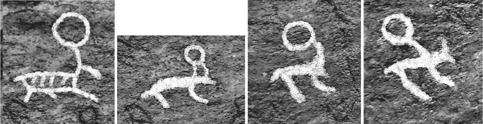
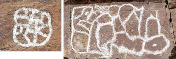
Special attention should be given to the images of jumping deer with circles on the antlers, pecked on Mount Xianglushan (Fig. 2). It is generally
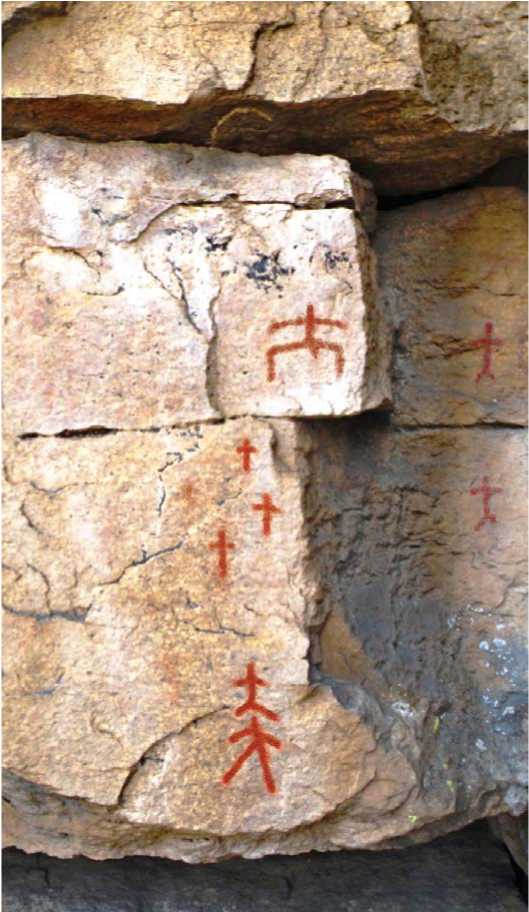
Fig. 1 . Composition of anthropomorphic figures and representation of a woman giving birth (above). Tianshuling 2.
5 cm
Fig. 2 . Deer with circles on their antlers. Xianglushan.
accepted that figures in the form of a circle are a symbolic representation of the sun which the celestial deer carries on its antlers. The image of the celestial deer-sun is common for ancient religious and mythological traditions. “The deer and a little later the horse as symbols of the sun, as animals dedicated to the solar deity, played an important role in the solar cults of many peoples of the steppes of Europe and Asia in the first millennium BC. However, the cult of the solar deity is even more ancient. In North Asia and Europe, symbols of the sun are already found among the Neolithic drawings in petroglyphic complexes” (Okladnikov, Martynov, 1972: 225). Images of the cosmic deer or elk, the animal-sun, are often found among the petroglyphs of Eurasia. Such images on the Kamennye Islands on the Angara River, on the rocks in Mongolia, stone massifs on the Tom River, and other locations are interpreted precisely as symbols of the zoomorphic sun.
The image of the deer-sun was the main focus of publications by Okladnikov, who found local modifications of the Golden-Antlered Deer not only on the rocks of Eurasia, but also on the “deer stones” of the Trans-Baikal region and Tuva. “Animals on deer stones are also solar symbols. Not only do they fly through the air; they are also equipped with the symbols of the sun: circles depicted above, in front of the muzzles of the animals. The deer fly upward, as if following a solar disk” (Ibid.). A vivid example of such symbolism according to the interpretation of Okladnikov was the composition pecked on the Ivolga Stele. In the article “Deer Stone from the Ivolga River”, Okladnikov focused on the circles, discs, pecked above the heads of the deer, and wrote, “… On the obverse of our stone, a circle grows immediately and directly from the antlers of the deer; in addition, a rod on which it is depicted, resembles the side handle of a mirror which commonly occurs among the antiquities of our Black Sea region” (Okladnikov, 1954: 215). In the subsequent publications, while interpreting the circle as a mirror, Okladnikov emphasized the paramount importance of solar symbolism which is the key to the semantics of the symbol. In the book, The Golden-Antlered Deer , Okladnikov thus noted, “Since old times, the shining mirror served as a counterpart and a symbol of the solar disk in the mythology of various ancient peoples. In turn, even in the Stone Age, the sun was conceived as a living cosmic being, a deer with golden antlers shining with unbearable brilliance, who runs across the entire sky from day to day, from east to west. And that is why, so that there were no doubts, the artist of the Bronze Age pecked not just a deer on the stone, but a deer with the solar disk above the antlers—the Golden-Antlered Deer” (Okladnikov, 1989: 132). The deer with discs on the antlers, pecked at the top of Mount Xianglushan, are a local version of the image of the deer-sun: a zoomorphic deity or heavenly companion of the sun-god.
Some figures on the rocks of Xianglushan can be interpreted as images of goats. According to the publications of Chinese scholars, the drawings of Jiaolaohedao might have represented dogs (Chen Zhaofu, 2009: 42).
Red-orange ocher images of two large animals, most likely boars, appear on Mount Tianshuling, on a rock plane measuring 30 × 40 cm. We should note that even today many wild boars which are dangerous for people live in these areas. The animals were drawn in a vertical projection one above the other and almost touch each other with their heads. The creator of the composition apparently wanted to depict the scene of a fight between two wild boars and used the vertical projection of the representations to emphasize the unusual nature of the clash. One of the animals is attacking from above, and the other one is approaching it from below. We can assume that the composition conveys a mythological subject with the motive of a struggle between magical animals. Such motives are typical for cosmogonist, eschatological, etiological, shamanistic, and some other types of mythological narratives. It is known that wild boars are characterized by enormous strength, fury, and courage, and play an important role in the religious and mythological beliefs of many peoples.
The composition on Mount Shijiangshan is distinguished by a great variety of zoomorphic imagery. According to the publication of Chinese scholars, in 1986–1987 there were figures of deer, horses, cows, tigers, and other animals depicted on a rock wall covering an area of about 80 m2 (Liaoning…, 2004). They were incised with fine lines in an elegant and realistic manner, far from the archaic style. When surveyed in 2013, the area of rock surface with representations was already about 20 m2. Most of the drawings were lost due to the destruction of the rock during the extraction of building stone. By now, only two images of deer have survived.
A naturalistic image of a bird is also depicted on Mount Shijiangshan. We have found no other unmistakable ornithomorphic images among the Dongbei petroglyphs.
Teratomorphic images were created in the form of various monstrous creatures including dragons. Images of dragons (currently lost) were represented at the Shijiangshan site. A fragment of the composition on plane 1 at Shenzhifeng can be confidently interpreted as a serpentine horned creature.
Usually, figurative images on the planes represent independent characters which do not have an obvious connection with other creatures. On some surfaces, anthropomorphic and zoomorphic creatures are shown in interaction. Thus, among the petroglyphs of Shenzhifeng, Tianshuling, and Gaxiandong, anthropomorphic figures form chains and other compositions which can be interpreted as ritual dance, collective prayer, or as social, family bonding. The image of a woman giving birth and surrounded by anthropomorphic figures manifests the relationship of birth and kinship, originating from the woman. An anthropomorphic creature pulling a deer is depicted at the site of Qunli and must have represented the scene of domestication of deer. The two boars, depicted at the site of Tianshuling, represent the mythological subject of the clash between two adversaries. A sophisticated composition of anthropomorphic figures enclosed in a rectangle at the Longtoushan site, some of which were drawn upside down, possibly shows the connection between the living and the dead: the dual structure of the community consisting of people living in this world and their relatives, ancestors, who reside in the other world.
The most common abstract imagery of Northeast China includes dots, lines (vertical, horizontal, or slanting), crosses (straight and slanting), circles, arrowshaped and V-shaped signs, “goose paws” (“tridents”), or cup-shaped depressions (concavities). The semantics of these signs, individually or in combination, are ambiguous and controversial. Since this has been analyzed with varying degrees of conclusiveness by many authors, we will not offer our own interpretations.
Another group of abstract images are structurally complex signs and compositions combining geometric figures, straight and curved lines, dots, etc. The semantics of abstract compositions is as ambiguous as the semantics of simple abstract signs. The reconstructions of their meaning and function highly vary. From our point of view, several types of complex symbolic compositions can be distinguished among the petroglyphs of Dongbei.
On the petroglyphs of Aniangni, Gaxiandong, Shenzhifeng, and Dongmazongshan, some signs formed by the combinations of geometric figures and lines are tamgas .
Some rock compositions at the sites of Longtoushan and Tianshuling represent stylized images of important fragments of the worldview or the image of the society. As we have already noted, a rectangle is depicted with ocher paint on the rock at Longtoushan; anthropomorphic creatures are drawn inside, some upside down. It is possible that the rectangle represents one of the versions of “fences”, representations of which can often be found on petroglyphs. Thus, rock representations of the Selenga type are widespread in the north of Mongolia and in the Trans-Baikal region. “The most typical subjects of these representations are ‘fences’ with oval or round spots…” (Okladnikov, 1981: 68). Other objects, such as anthropomorphic figures, are often shown inside the “fence”. Okladnikov suggested that the “fences” recreated the image of the universe, and symbolized “simultaneously the community-family clan or tribe, while small human figures or spots placed within them signify the members of that community” (Okladnikov, Zaporozhskaya, 1970: 91). Some “fences”
are divided into two halves. Such a structure “reminds us of the division into two halves, typical of the nomadic societies in Siberia and Central Asia” (Ibid.). According to Okladnikov, this “reveals the dual organization of the primitive community, a universal, global phenomenon”. From this perspective, the double “fences” acted as “a symbolic image of a community consisting of two exogamous halves” (Ibid.: 92).
We should consider the petroglyphs from the site of Longtoushan in light of this idea of Okladnikov. The composition at Longtoushan is a rectangle with anthropomorphic figures inside. It depicts the community, family clan, or tribe. The dual structure of the composition, consisting of anthropomorphic figures, shown in the upper part in the normal position and in the lower part with their heads down, reflects the division of the archaic community into two halves: those living in this world and those dwelling in the other world. Beliefs concerning the dual structure of a community as consisting of two parts (the living relatives and deceased relatives) are typical of archaic cultures. Being a symbol of the community’s unity and the link between the generations, the petroglyphs of Longtoushan might serve as markers of the zone where the rituals of the ancestors’ cult or community rituals with similar meaning were performed for strengthening the cohesion of the tribal collective and its self-identity.
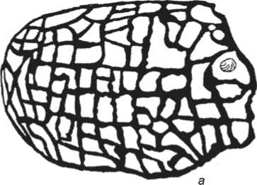
Two representations of a labyrinth were pecked on the rocks on Mount Xianglushan. Similar images have been found on the rocks in the Trans-Baikal region, Mongolia, and North America (for example, in the Grapevine Canyon). In the study of the petroglyphs of the Mongolian Altai (Zagaan-Salaa and Baga-Oyuogura), V.D. Kubarev, D. Tseveendorj, and E. Yakobson interpreted figures visually similar to compositions of Xianglushan as “mazes”, “networks”, or as “indeterminate” or “unidentifiable” representations (Kubarev, Tseveendorj, Yakobson, 2005: 605) (Fig. 3). Clearly, labyrinths are one of the most difficult symbols for study. Graphic visualizations of labyrinths are devoid of ethnic and cultural details, which makes it difficult to carry out their identification, date them, and determine their function. Judging by the materials of Paleolithic cave art, analyzed by A. Leroi-Gourhan, the image of the labyrinth was not typical of the Paleolithic, therefore, the graphic representations of labyrinths must have not appeared until the Neolithic (Leroi-Gourhan, 2009). The initial enigmatic nature of the labyrinths complicates their semantic interpretation (Zabiyako, 2015).
Determining the time of creation and functioning of petroglyphs is usually problematic. This fully applies to the images at the sites known from the Chinese publications and the sites which we have discovered.
The date for the Paleolithic petroglyphs of Dongbei is controversial. Relying on the studies on Chinese
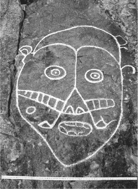
Fig. 4 . Face. Daheishan.
b
Fig. 3 . Representation of a net or labyrinth. Mongolian Altai ( a ), Xianglushan ( b ).
petroglyphs, Zhang Xirong suggested that images in the form of cup-shaped depressions in Liaoning Province (Heicheng, Anshan, Yufoshan, etc.) were created in the Late Paleolithic–Bronze Age. Zhang Xirong cited the data of Chinese scholars that, for example, the petroglyphs of Tamedi (the Ningxia Hui Autonomous District) were created in 13,000 BP; the petroglyphs of Lianyungang (Shandong Province) in 8000 BP; the petroglyphs of Daishan (Shandong Province) in 6500 BP; the petroglyphs of Jucishan (Henan Province) in 4000 BP, and the petroglyphs of Daheishan (Inner Mongolia) in 5500–4200 BP (Zhang Xirong, 2010: 95–98). According to Zhang Xirong, the petroglyphs of the Anshan-Heicheng region appeared before many of the above-mentioned rock representations were made. An important argument in favor of such a conclusion is that the Heicheng site is located 10 km from the Paleolithic site of Xiaogushan, the cave where humans of the Upper Paleolithic Age lived (ca. 19,000 BP). According to Zhang Xirong, it was precisely the inhabitants of the cave that were the first creators of the petroglyphic representations (2010). We have studied rock representations of this region. Indeed, there are man-made cup-shaped cavities on large boulders mentioned by Zhang Xirong in the Anshan and Yufoshan areas, as well as on the boulders at the Xianrendong site in the same region, which were discovered by us. However, the presence of such cavities at the locations near the Xiaogushan site does not give us sufficient grounds for dating the object to the Paleolithic. Cup-shaped cavities widely occur in different regions of the world and belong to different periods from the Paleolithic to the Middle Ages. From our point of view, none of the petroglyphic complexes on the Liaodong Peninsula and in Northeast China as a whole, which we examined, can yet be reliably dated to the Paleolithic.
In our opinion, some compositions from Aniangni, Gaxiandong, Tianshuling, Shenzhifeng, Shenxiandong, Dongmazongshan, Xianglushan, Yufoshan, and Xianrendong belong to the Late Neolithic. Some compositions and images from Aniangni, Gaxiandong, Tianshuling, Shenzhifeng, Shenxiandong, Longtoushan, Dongmazongshan, Xianglushan, Yufoshan, and Xianrendong belong to the Paleometal. The petroglyphs of Yagou, Shijiangshan, Yushan, Daheishan, and Qunli were created in the Middle Ages.
The proposed dates are preliminary. At present, the dates of rock representations of Northeast China and Inner Mongolia remain controversial. Thus, the Chinese scholars consider the faces represented on the rocks of Daheishan, as well as some other geographically close representations, as belonging to the Neolithic. Drawing upon the historical reconstruction of shamanism practiced by the peoples of Northeast China and Inner Mongolia, and the ideas of the role of shaman masks in the genesis of the petroglyphs, Ge Shanlin and Ge Zhihao came to the conclusion that the petroglyph-masks of Inner Mongolia were pecked following the images of masks of ancient shamans (2002: 347). The scholars believe that the tradition of creating petroglyph-masks “begins in the Neolithic, flourishes in the Bronze Age, and gradually fades in the New Era by the Tang Dynasty”; in the period of decline, “there was a tendency towards an increase in the number of images in the form of square petroglyphmasks, in which the facial features were rendered in an abstract manner” (Ibid.: 358). The end of the Tang Dynasty (616–907) was the time when the Khitan people created the Great Liao State on the territory where the face-masks of Daheishan were found. The practice of creating rock representations and using shamanic masks, including burial masks, might have continued to exist in the Daheishan area in the Tang period and could have been associated with the Khitan culture (Fig. 4).
The faces of Daheishan show similarities to the faces of Inner Mongolia, primarily to rock representations of Yinshan, Denkou, Alpas, Hoyarbogda, and some other locations. Russian archaeologists have proposed their own dating for the petroglyphs of this type. Thus, E.G. Devlet and M.A. Devlet noted the difficulties of dating the images of the faces from Inner Mongolia, since these images were created at different times. At the same time, they believed that the earliest of the above representations dated back to the Chalcolithic, while the latest went back to the Late Bronze Age– Early Iron Age and could be dated to the late second– early first millennium BC. E.G. Devlet and M.A. Devlet did not exclude the possibility that individual images could have been represented on the rocks at a later time (Devlet E.G., Devlet M.A., 2005: 289–290). Obviously, this chronological framework offered by E.G. Devlet and M.A. Devlet significantly differs from the dates proposed by the Chinese scholars, especially from the definitions of the late stages of the functioning of the masks from Inner Mongolia.
The dates suggested by the Russian and Chinese scholars result from studying the imagery, semantic content, and stylistics of the Dongbei petroglyphs, as well as their comparison on these grounds with the rock representations of the adjacent territories (Mongolia, Trans-Baikal region, Amur region, etc.), which have a generally accepted periodization. It is clear that these methodologies are not sufficient for considering the conclusions on the dates, ethnic and cultural attribution, and functioning of petroglyphic complexes to be fully substantiated. Our study has shown that the petroglyphic complexes of Manchuria require further research.
Conclusions
The petroglyphs of Northeast China are very rich in historical, cultural, and religious terms. First, they serve as a source for reconstructing the way of life and spiritual culture of the population living on a huge and extremely important territory from a historical point of view. Some of the original ethnic and cultural traditions which originated in Manchuria, evolved and merged with the traditions of the neighboring populations, and spread outward, influencing the cultures not only of the nomadic peoples of East Asia, but also of the population of China. Second, the rock art of Dongbei is a part of the numerous petroglyphs of Eurasia, and is closely associated with the rock art of Mongolia, the Trans-Baikal region, Amur region, and Korea. The study of the petroglyphs of Manchuria is a necessary stage in the formation of a comprehensive idea of chronology, styles, meanings, functions, and other aspects of rock representations in the Northeast of Eurasia, as well as the history and culture of this part of the Eurasian continent.
Acknowledgements
This study was supported by the Russian Science Foundation (Project No. 14-18-00308).
